January 7th 2022 Snowstorm Threat
+41
WeatherBob
skinsfan1177
SENJsnowman
brownie
Scullybutcher
Radz
frank 638
crippo84
algae888
bluebythec
2004blackwrx
bobjohnsonforthehall
weatherwatchermom
dkodgis
Irish
emokid51783
Dunnzoo
mmanisca
Math23x7
essexcountypete
rb924119
obsessedwithweather
docstox12
mikeypizano
hyde345
Snow88
Sanchize06
jmanley32
nutleyblizzard
GreyBeard
billg315
sroc4
CPcantmeasuresnow
MattyICE
aiannone
phil155
SoulSingMG
amugs
heehaw453
dsix85
Frank_Wx
45 posters
Page 4 of 15
Page 4 of 15 •  1, 2, 3, 4, 5 ... 9 ... 15
 Re: January 7th 2022 Snowstorm Threat
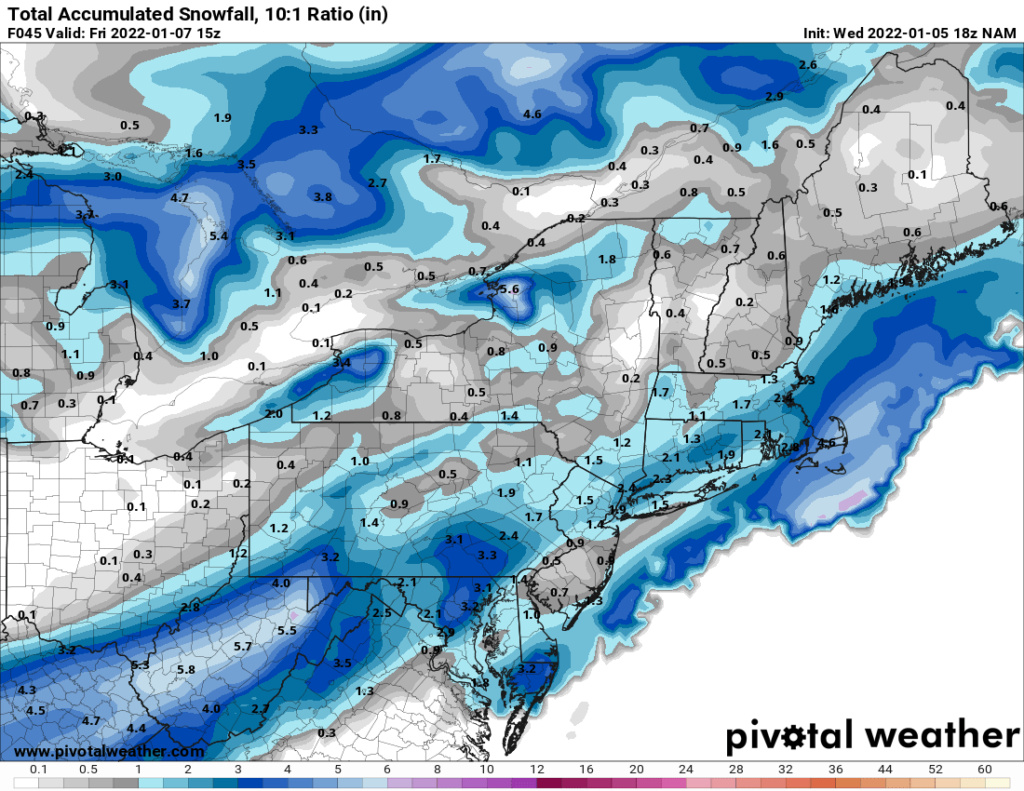
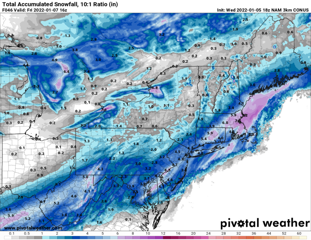
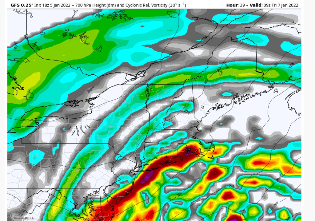
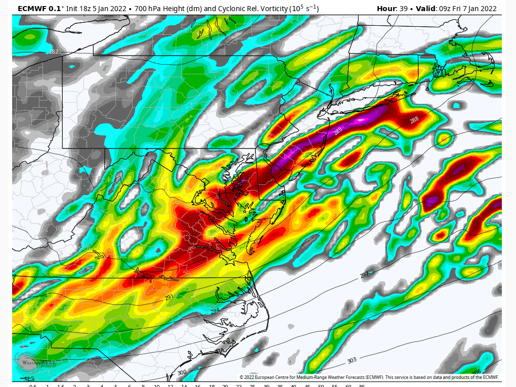
Looks like from that map the same for NYC on north into my neck of the woods, just been watching the forum as been busy with work. Reel this one in guys! Looking more or less or the same in terms of seeing 6+ somewhere?amugs wrote:Globals are starting to resolve the meso and ingredients set up I would assume but the mess have the physics and algorithms to pick this up.
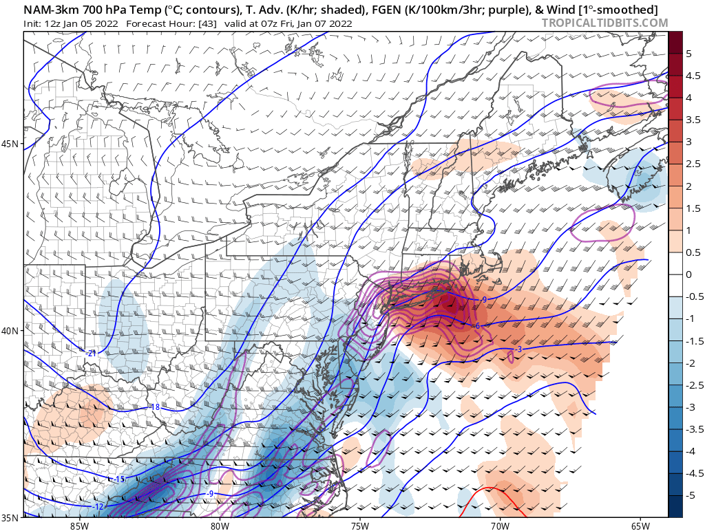
SROC pointed it out before with the 3K NAM and the HRRR and HREFs have it as well as the RGEM. Very interesting for sure.
Where and if this PVA sets up can be the difference between 2" and 4".
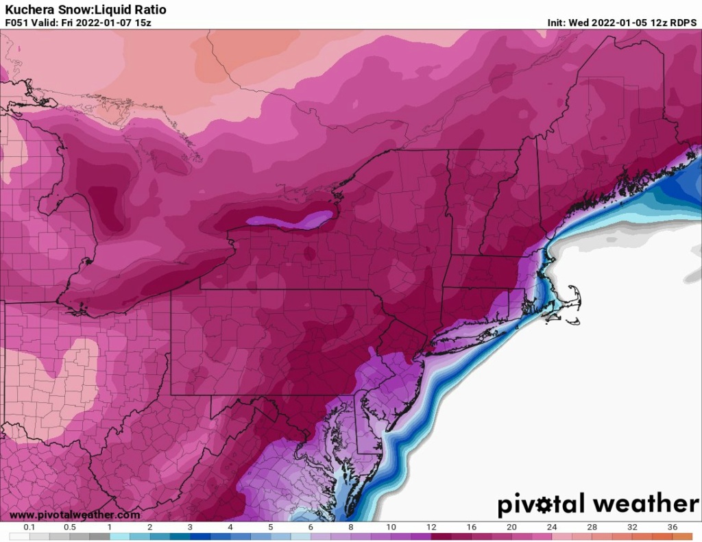
Also ratios will be 12:15-1 in NNJ on North.
jmanley32- Senior Enthusiast

- Posts : 20535
Join date : 2013-12-12
aiannone- Senior Enthusiast - Mod

- Posts : 4815
Join date : 2013-01-07

aiannone- Senior Enthusiast - Mod

- Posts : 4815
Reputation : 92
Join date : 2013-01-07
Location : Saint James, LI (Northwest Suffolk Co.)
phil155 likes this post
 Re: January 7th 2022 Snowstorm Threat
Hazardous Weather Outlook
National Weather Service New York NY
333 PM EST Wed Jan 5 2022
ANZ345-CTZ005>012-NYZ078>081-177-179-062045-
South Shore Bays from Jones Inlet through Shinnecock Bay-
Northern Fairfield-Northern New Haven-Northern Middlesex-
Northern New London-Southern Fairfield-Southern New Haven-
Southern Middlesex-Southern New London-Northwest Suffolk-
Northeast Suffolk-Southwest Suffolk-Southeast Suffolk-
Northern Nassau-Southern Nassau-
333 PM EST Wed Jan 5 2022
This Hazardous Weather Outlook is for Atlantic coastal waters,
southern Connecticut and southeast New York.
.DAY ONE...Tonight.
Hazardous weather is not expected at this time.
.DAYS TWO THROUGH SEVEN...Thursday through Tuesday.
Low pressure is expected to produce a round of snow late Thursday
night into Friday. Although there is still some certainty regarding
the exact track, timing, and intensity of the system, a general 2 to
4 inch snowfall is expected across the area. The snowfall is
expected to impact the Friday morning commute.
_________________
-Alex Iannone-

aiannone- Senior Enthusiast - Mod

- Posts : 4815
Reputation : 92
Join date : 2013-01-07
Location : Saint James, LI (Northwest Suffolk Co.)
phil155- Pro Enthusiast

- Posts : 483
Reputation : 4
Join date : 2019-12-16

mikeypizano- Pro Enthusiast

- Posts : 1118
Reputation : 66
Join date : 2017-01-05
Age : 35
Location : Wilkes-Barre/Scranton, PA
RJB8525 likes this post
 Re: January 7th 2022 Snowstorm Threat
Interesting difference from Accuweather saying 3 to 6 and NWS saying 1 to 2 in my area. I would be happy with 3 at this point.24 hours to nowcast anyway.

docstox12- Wx Statistician Guru

- Posts : 8530
Reputation : 222
Join date : 2013-01-07
Age : 73
Location : Monroe NY
heehaw453- Advanced Forecaster

- Posts : 3906
Reputation : 86
Join date : 2014-01-20
Location : Bedminster Township, PA Elevation 600' ASL
heehaw453- Advanced Forecaster

- Posts : 3906
Reputation : 86
Join date : 2014-01-20
Location : Bedminster Township, PA Elevation 600' ASL
 Re: January 7th 2022 Snowstorm Threat
_________________
Mugs
AKA:King: Snow Weenie
Self Proclaimed
WINTER 2014-15 : 55.12" +.02 for 6 coatings (avg. 35")
WINTER 2015-16 Total - 29.8" (Avg 35")
WINTER 2016-17 : 39.5" so far

amugs- Advanced Forecaster - Mod

- Posts : 15095
Reputation : 213
Join date : 2013-01-07
Age : 54
Location : Hillsdale,NJ
 Re: January 7th 2022 Snowstorm Threat
_________________
Mugs
AKA:King: Snow Weenie
Self Proclaimed
WINTER 2014-15 : 55.12" +.02 for 6 coatings (avg. 35")
WINTER 2015-16 Total - 29.8" (Avg 35")
WINTER 2016-17 : 39.5" so far

amugs- Advanced Forecaster - Mod

- Posts : 15095
Reputation : 213
Join date : 2013-01-07
Age : 54
Location : Hillsdale,NJ
Judy Margolis and phil155 like this post
 Re: January 7th 2022 Snowstorm Threat
Upton Disco... 
The 12Z NAM, GFS, and ECMWF are all in good agreement with the track
and timing of low pres tracking se of the benchmark Thu ngt into
Fri. This would produce a 1-3 inch snowfall west and 2-4 inches
east. The fcst follows this thinking.
The overall model trend has been east with the sys, so it would not
be surprising to see a further ewd trend in future model runs. Any
trend w would produce more snow. Because of the trend, and current
snow totals blw advy criteria in many places, will not issue an advy
with this fcst. The snowfall potential will continue to be
highlighted in the hwo and idss briefing products.
Most of the snow will occur late Thu ngt into Fri mrng, which will
impact the mrng commute.
_________________
-Alex Iannone-

aiannone- Senior Enthusiast - Mod

- Posts : 4815
Reputation : 92
Join date : 2013-01-07
Location : Saint James, LI (Northwest Suffolk Co.)
 Re: January 7th 2022 Snowstorm Threat
I’m pretty much in the same camp as Upton.
Snow is snow! From what I see in the medium to long range there is going to be ample opportunities to go
Snow is snow! From what I see in the medium to long range there is going to be ample opportunities to go
_________________
_______________________________________________________________________________________________________
CLICK HERE to view NJ Strong Snowstorm Classifications
rb924119 and SENJsnowman like this post
 Re: January 7th 2022 Snowstorm Threat
At this stage if I get enough to completely cover the grass I suppose I’ll take it. I won’t necessarily be happy about it but.......

CPcantmeasuresnow- Wx Statistician Guru

- Posts : 7274
Reputation : 230
Join date : 2013-01-07
Age : 103
Location : Eastern Orange County, NY
rb924119 and dkodgis like this post
 Re: January 7th 2022 Snowstorm Threat
NWS own blended model. In total disagreement with Upton LOL!


_________________
Mugs
AKA:King: Snow Weenie
Self Proclaimed
WINTER 2014-15 : 55.12" +.02 for 6 coatings (avg. 35")
WINTER 2015-16 Total - 29.8" (Avg 35")
WINTER 2016-17 : 39.5" so far

amugs- Advanced Forecaster - Mod

- Posts : 15095
Reputation : 213
Join date : 2013-01-07
Age : 54
Location : Hillsdale,NJ
 Re: January 7th 2022 Snowstorm Threat
amugs wrote:NWS own blended model. In total disagreement with Upton LOL!
Maybe we can pull the last minute NW shift haha
_________________
-Alex Iannone-

aiannone- Senior Enthusiast - Mod

- Posts : 4815
Reputation : 92
Join date : 2013-01-07
Location : Saint James, LI (Northwest Suffolk Co.)
heehaw453- Advanced Forecaster

- Posts : 3906
Reputation : 86
Join date : 2014-01-20
Location : Bedminster Township, PA Elevation 600' ASL
amugs, phil155 and Bwtr like this post
 Re: January 7th 2022 Snowstorm Threat
_________________
-Alex Iannone-

aiannone- Senior Enthusiast - Mod

- Posts : 4815
Reputation : 92
Join date : 2013-01-07
Location : Saint James, LI (Northwest Suffolk Co.)
SENJsnowman likes this post
 Re: January 7th 2022 Snowstorm Threat
GEFS come West. The gyrations continue.


_________________
Mugs
AKA:King: Snow Weenie
Self Proclaimed
WINTER 2014-15 : 55.12" +.02 for 6 coatings (avg. 35")
WINTER 2015-16 Total - 29.8" (Avg 35")
WINTER 2016-17 : 39.5" so far

amugs- Advanced Forecaster - Mod

- Posts : 15095
Reputation : 213
Join date : 2013-01-07
Age : 54
Location : Hillsdale,NJ
 Re: January 7th 2022 Snowstorm Threat
0Z will be telling and hopefully the WC sharpens a tad allowing for the energy to consolidate and we need the confluence to weaken and move a tad N to get this to move NW.
_________________
Mugs
AKA:King: Snow Weenie
Self Proclaimed
WINTER 2014-15 : 55.12" +.02 for 6 coatings (avg. 35")
WINTER 2015-16 Total - 29.8" (Avg 35")
WINTER 2016-17 : 39.5" so far

amugs- Advanced Forecaster - Mod

- Posts : 15095
Reputation : 213
Join date : 2013-01-07
Age : 54
Location : Hillsdale,NJ
 Re: January 7th 2022 Snowstorm Threat
Good read from DT
https://dtwxrisk.medium.com/1st-call-snowfall-map-jan-6-7-event-for-tn-se-ky-wvava-md-del-se-third-of-pa-nj-southeast-third-of-d4789c9c3e87
https://dtwxrisk.medium.com/1st-call-snowfall-map-jan-6-7-event-for-tn-se-ky-wvava-md-del-se-third-of-pa-nj-southeast-third-of-d4789c9c3e87
_________________
-Alex Iannone-

aiannone- Senior Enthusiast - Mod

- Posts : 4815
Reputation : 92
Join date : 2013-01-07
Location : Saint James, LI (Northwest Suffolk Co.)
 Re: January 7th 2022 Snowstorm Threat
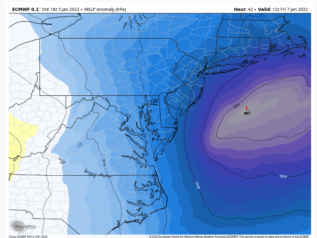
Euro is west. H5 looks much better. Good precip into NJ and NYC along with SNE

Snow88- Senior Enthusiast

- Posts : 2193
Reputation : 4
Join date : 2013-01-09
Age : 35
Location : Brooklyn, NY
heehaw453- Advanced Forecaster

- Posts : 3906
Reputation : 86
Join date : 2014-01-20
Location : Bedminster Township, PA Elevation 600' ASL
 Re: January 7th 2022 Snowstorm Threat
If you look at the models now, there seems to be pretty broad agreement on this as a 2-4" event, with areas south and east more likely to hit the 4" and areas to north and west more likely to get the 2". I could see if things developed a little more favorably (last Euro had some positives at the upper levels) it could become a 4-6" storm, but really I think we're locking in on the former. At this point I'll take my 2 or 3" of white landscape decoration and turn my eyes to the third week of January for the whole megillah.

billg315- Advanced Forecaster - Mod

- Posts : 4483
Reputation : 185
Join date : 2015-01-24
Age : 50
Location : Flemington, NJ
heehaw453- Advanced Forecaster

- Posts : 3906
Reputation : 86
Join date : 2014-01-20
Location : Bedminster Township, PA Elevation 600' ASL
Bwtr likes this post

billg315- Advanced Forecaster - Mod

- Posts : 4483
Reputation : 185
Join date : 2015-01-24
Age : 50
Location : Flemington, NJ
 Re: January 7th 2022 Snowstorm Threat
billg315 wrote:
All the models seem to have this energy across SNJ presently (the Canadian a little further north). Would be ironic if they got the best action out of this again -- two times in one week.
I was thinking the same billg when looking at this. Seems almost a carbon copy of what happened a few days ago.

docstox12- Wx Statistician Guru

- Posts : 8530
Reputation : 222
Join date : 2013-01-07
Age : 73
Location : Monroe NY
billg315 likes this post
Page 4 of 15 •  1, 2, 3, 4, 5 ... 9 ... 15
Page 4 of 15
Permissions in this forum:
You cannot reply to topics in this forum
 Home
Home