Tracking JAN 29th 2022 'The Phase'
+51
DWay
Bwtr
Quietace
Joe Snow
Sanchize06
JT33
Zhukov1945
uanswer2me
gigs68
billg315
freezerburn
dolphins222
rb924119
hurrysundown23
dsix85
docstox12
crippo84
lglickman1
SoulSingMG
mikeypizano
TheAresian
moleson
Fededle22
skinsfan1177
Wheezer
Artechmetals
Irish
weatherwatchermom
Dunnzoo
bloc1357
Scullybutcher
hyde345
SNOW MAN
richb521
RJB8525
Carvin
essexcountypete
nutleyblizzard
CPcantmeasuresnow
phil155
MattyICE
amugs
mmanisca
bobjohnsonforthehall
aiannone
sroc4
SENJsnowman
jmanley32
frank 638
heehaw453
Frank_Wx
55 posters
Page 9 of 31
Page 9 of 31 •  1 ... 6 ... 8, 9, 10 ... 20 ... 31
 Re: Tracking JAN 29th 2022 'The Phase'
Frank_Wx wrote:None of us should look nor care about the 18z GFS, but you damn well know we will.
Of course we will. And if it shows a miss we will say "it's an off hour run" and if it buries us we will say "the trend west is back and just because it's an off hour run doesn't mean we cant trust it!"
aiannone- Senior Enthusiast - Mod

- Posts : 4822
Join date : 2013-01-07
crippo84 and agorr1188 like this post
 Re: Tracking JAN 29th 2022 'The Phase'
18z GFS northern vort a bit stronger through 48
aiannone- Senior Enthusiast - Mod

- Posts : 4822
Join date : 2013-01-07
 Re: Tracking JAN 29th 2022 'The Phase'
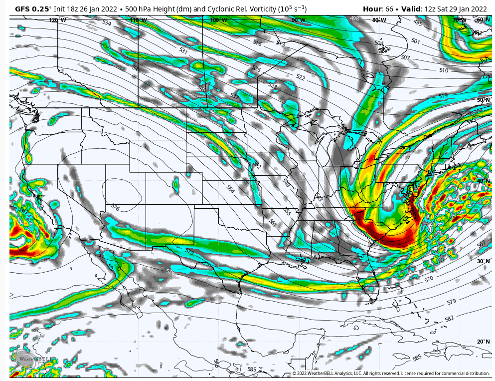
GFS is better. More meridional with the northern heights and more southern energy is bring phased into the trough

_________________
_______________________________________________________________________________________________________
CLICK HERE to view NJ Strong Snowstorm Classifications
 Re: Tracking JAN 29th 2022 'The Phase'
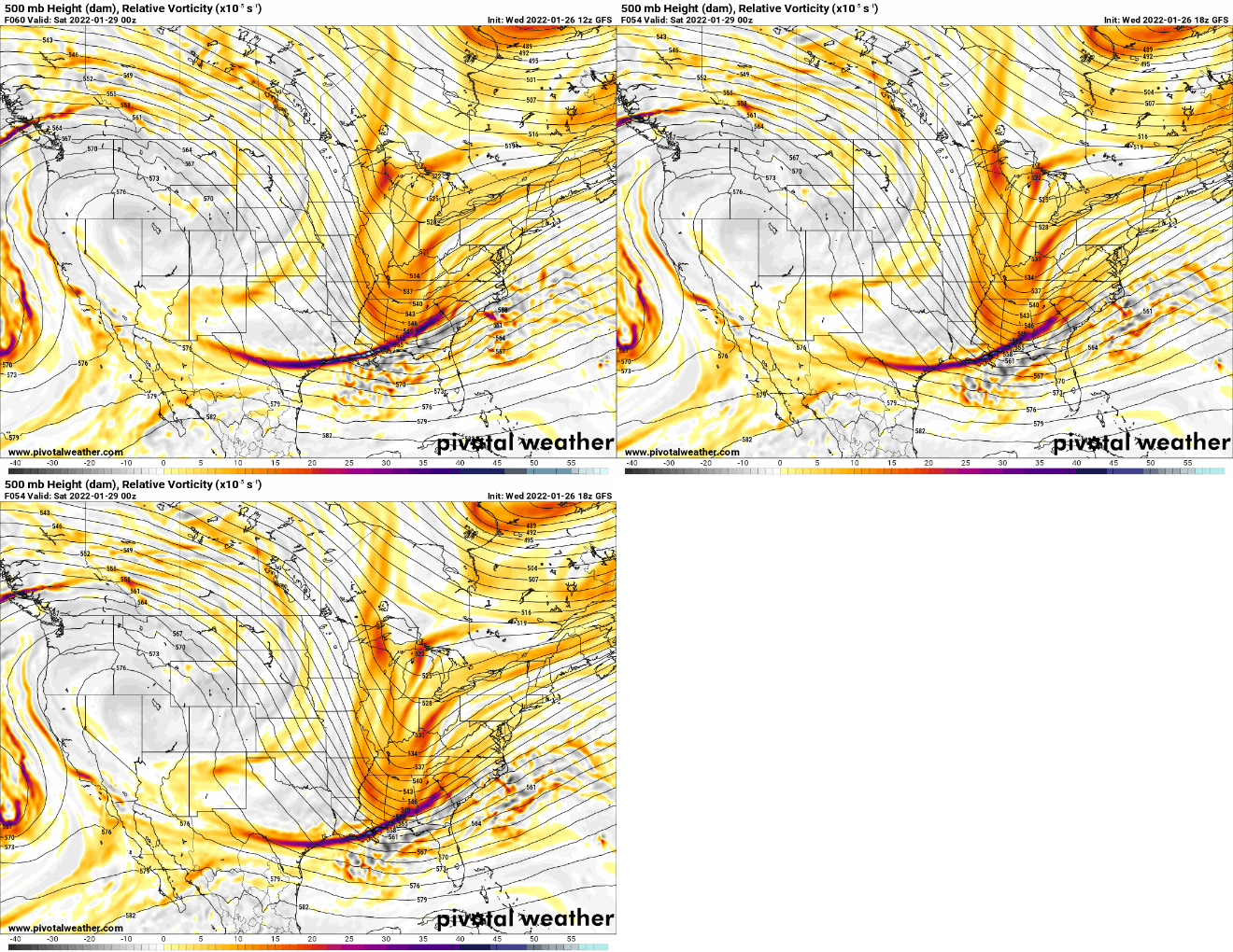
What a BIG change at 500mb

_________________
_______________________________________________________________________________________________________
CLICK HERE to view NJ Strong Snowstorm Classifications
 Re: Tracking JAN 29th 2022 'The Phase'
Dont think its going to translate to the surface, cause you know, that would be too easy
_________________
_______________________________________________________________________________________________________
CLICK HERE to view NJ Strong Snowstorm Classifications
 Re: Tracking JAN 29th 2022 'The Phase'
Frank_Wx wrote:What a BIG change at 500mb
Good changes or bad changes?
I can not view what was posted
phil155- Pro Enthusiast

- Posts : 494
Reputation : 4
Join date : 2019-12-16
 Re: Tracking JAN 29th 2022 'The Phase'
I know this has probably been explained before but if there are big improvements in the upper levels why does the surface maps not reflect that? 18z was basically a miss but I know if you say upper levels are good thats what we want.Frank_Wx wrote:Dont think its going to translate to the surface, cause you know, that would be too easy

jmanley32- Senior Enthusiast

- Posts : 20635
Reputation : 108
Join date : 2013-12-12
Age : 43
Location : Yonkers, NY
 Re: Tracking JAN 29th 2022 'The Phase'
GFS closes off late yet again. It has not closed off in time even for NYC in many runs. Clearly we are in a bad model cycle w.r.t. a faster developing storm. We have some time, but I think we got to start seeing it 00Z tonight OR 12Z latest tomorrow otherwise this one probably gone.
heehaw453- Advanced Forecaster

- Posts : 3908
Reputation : 86
Join date : 2014-01-20
Location : Bedminster Township, PA Elevation 600' ASL
 Re: Tracking JAN 29th 2022 'The Phase'
phil155 wrote:Frank_Wx wrote:What a BIG change at 500mb
Good changes or bad changes?
I can not view what was posted
That is odd. Anyone else having an issue?
Positive change, as in more phasing and a trough going neutral a lot faster. The reason why surface did not translate is because too much upper air energy fled the base of the trough despite the better phasing. We need the trough to close off. I thought it was a run in the right direction. Maybe 00z's surprise us.
jmanley32 wrote:I know this has probably been explained before but if there are big improvements in the upper levels why does the surface maps not reflect that? 18z was basically a miss but I know if you say upper levels are good thats what we want.Frank_Wx wrote:Dont think its going to translate to the surface, cause you know, that would be too easy
Could be trying to correct. We'll know soon enough..
_________________
_______________________________________________________________________________________________________
CLICK HERE to view NJ Strong Snowstorm Classifications
 Re: Tracking JAN 29th 2022 'The Phase'
Frank_Wx wrote:What a BIG change at 500mb
Don't pay attention to the surface but it goes neutral earlier BIG dhange. 500 isbhwere it's at for now.
_________________
Mugs
AKA:King: Snow Weenie
Self Proclaimed
WINTER 2014-15 : 55.12" +.02 for 6 coatings (avg. 35")
WINTER 2015-16 Total - 29.8" (Avg 35")
WINTER 2016-17 : 39.5" so far

amugs- Advanced Forecaster - Mod

- Posts : 15130
Reputation : 213
Join date : 2013-01-07
Age : 54
Location : Hillsdale,NJ
SENJsnowman likes this post
 Re: Tracking JAN 29th 2022 'The Phase'
There is no doubt in my mind that we should hav seen a better outcome on the GFS leading up to this image right here. If 500closes off literally no more than 3-6 hrs earlier this is a different result on the surface. Based on the amount of eenergy rounding the base of this trough, the depth of the trough and the axis of the trough in this position right here it should have cont to tilt neg and close off S of us rather than E of us IMO, but I am concerned that once again the lack of anything slowing the mean trough down in the Atlantic side prevents the energy to the west that is flattening the NE side of the ridge from pushing the entire mean trough off the coast just a few hours too fast.
Its still 48hrs out so still trends for better...or worse.
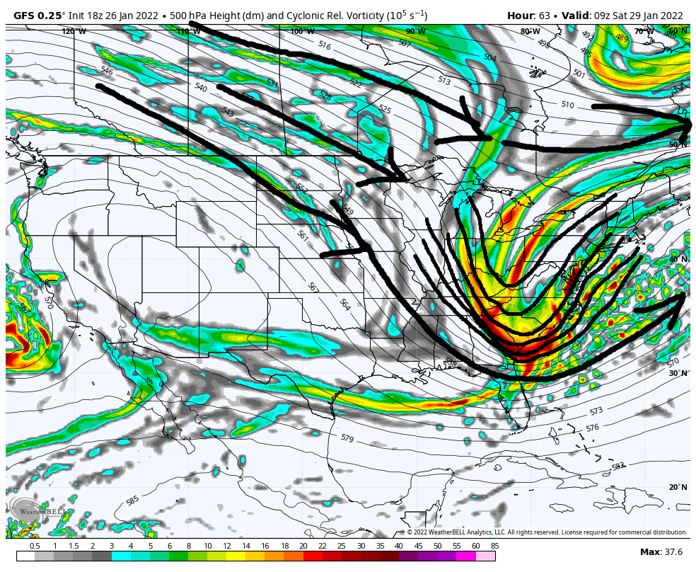
Its still 48hrs out so still trends for better...or worse.

Last edited by sroc4 on Wed Jan 26, 2022 5:11 pm; edited 1 time in total
_________________
"In weather and in life, there's no winning and losing; there's only winning and learning."
WINTER 2012/2013 TOTALS 43.65"WINTER 2017/2018 TOTALS 62.85" WINTER 2022/2023 TOTALS 4.9"
WINTER 2013/2014 TOTALS 64.85"WINTER 2018/2019 TOTALS 14.25" WINTER 2023/2024 TOTALS 13.1"
WINTER 2014/2015 TOTALS 71.20"WINTER 2019/2020 TOTALS 6.35"
WINTER 2015/2016 TOTALS 35.00"WINTER 2020/2021 TOTALS 37.75"
WINTER 2016/2017 TOTALS 42.25"WINTER 2021/2022 TOTALS 31.65"

sroc4- Admin

- Posts : 8442
Reputation : 302
Join date : 2013-01-07
Location : Wading River, LI
Frank_Wx likes this post
 Re: Tracking JAN 29th 2022 'The Phase'
Is there any chance we go back to the heavy hits we saw and it happening or is that completely off the table and now just focusing on getting a 6 inch storm maybe for NYC? Seems there has just been too much model changes for that to be completely off the table yet, IMO.

jmanley32- Senior Enthusiast

- Posts : 20635
Reputation : 108
Join date : 2013-12-12
Age : 43
Location : Yonkers, NY
 Re: Tracking JAN 29th 2022 'The Phase'
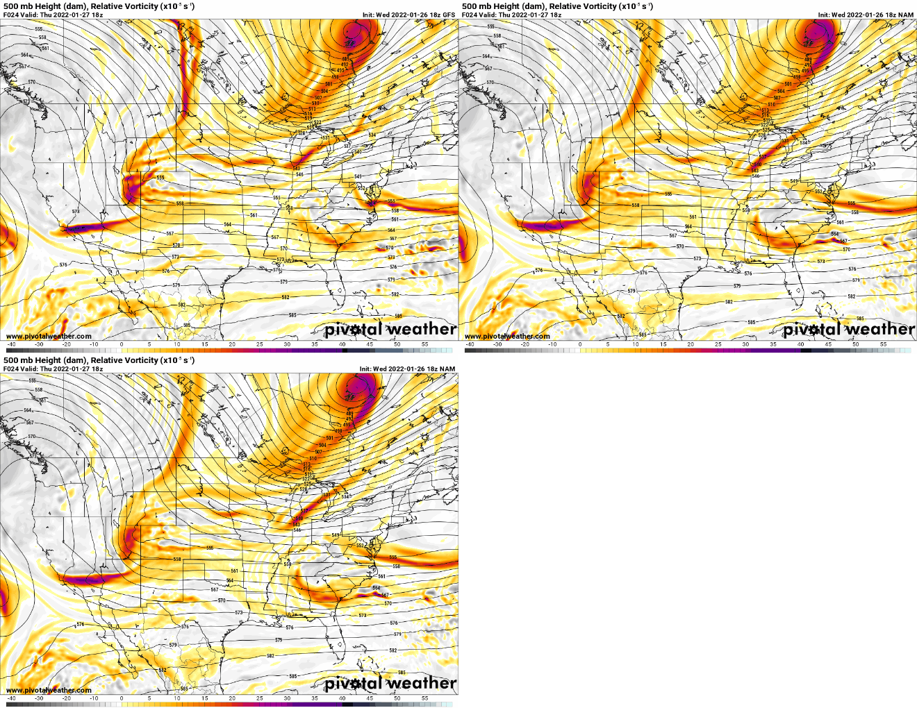
As mentioned this primarily comes down to the handling of the northern energy. Massive differences between the 18z NAM and GFS. To be honest, you can tell by the success or failure of this storm just by looking at the northern energy valid Thursday afternoon. We will be able to see early on in the 00z runs what they're doing with it.

_________________
_______________________________________________________________________________________________________
CLICK HERE to view NJ Strong Snowstorm Classifications
 Re: Tracking JAN 29th 2022 'The Phase'
amugs wrote:Frank_Wx wrote:What a BIG change at 500mb
Don't pay attention to the surface but it goes neutral earlier BIG dhange. 500 isbhwere it's at for now.
It's positive on the H5 that's for sure and the storm is deeper because of that, but GFS refuses to close off the ULL until past BM. It has been stubborn as a mule with regard to that close off. And that is the most important thing for sig snowfall chances unfortunately. It must close off close the coast around Ocean City.
heehaw453- Advanced Forecaster

- Posts : 3908
Reputation : 86
Join date : 2014-01-20
Location : Bedminster Township, PA Elevation 600' ASL
 Re: Tracking JAN 29th 2022 'The Phase'
Frank_Wx wrote:As mentioned this primarily comes down to the handling of the northern energy. Massive differences between the 18z NAM and GFS. To be honest, you can tell by the success or failure of this storm just by looking at the northern energy valid Thursday afternoon. We will be able to see early on in the 00z runs what they're doing with it.
This still has big dog potential for the I95. When you have a 519 dam closed off ULL anywhere near the BM it must be watched at very least. It's just the GFS is very stubborn on closing it off. Very workable at this range, but I would sure love to see the GFS show the money.
heehaw453- Advanced Forecaster

- Posts : 3908
Reputation : 86
Join date : 2014-01-20
Location : Bedminster Township, PA Elevation 600' ASL
Frank_Wx likes this post
 Re: Tracking JAN 29th 2022 'The Phase'
Even Upton is scratching their heads in the latest discussion. Are we watching weather model changes or the Bills v Chiefs divisional all over again? Will this come down to a coin toss? Who ya got?

crippo84- Posts : 383
Reputation : 20
Join date : 2013-11-07
Age : 40
Location : East Village, NYC
 Re: Tracking JAN 29th 2022 'The Phase'
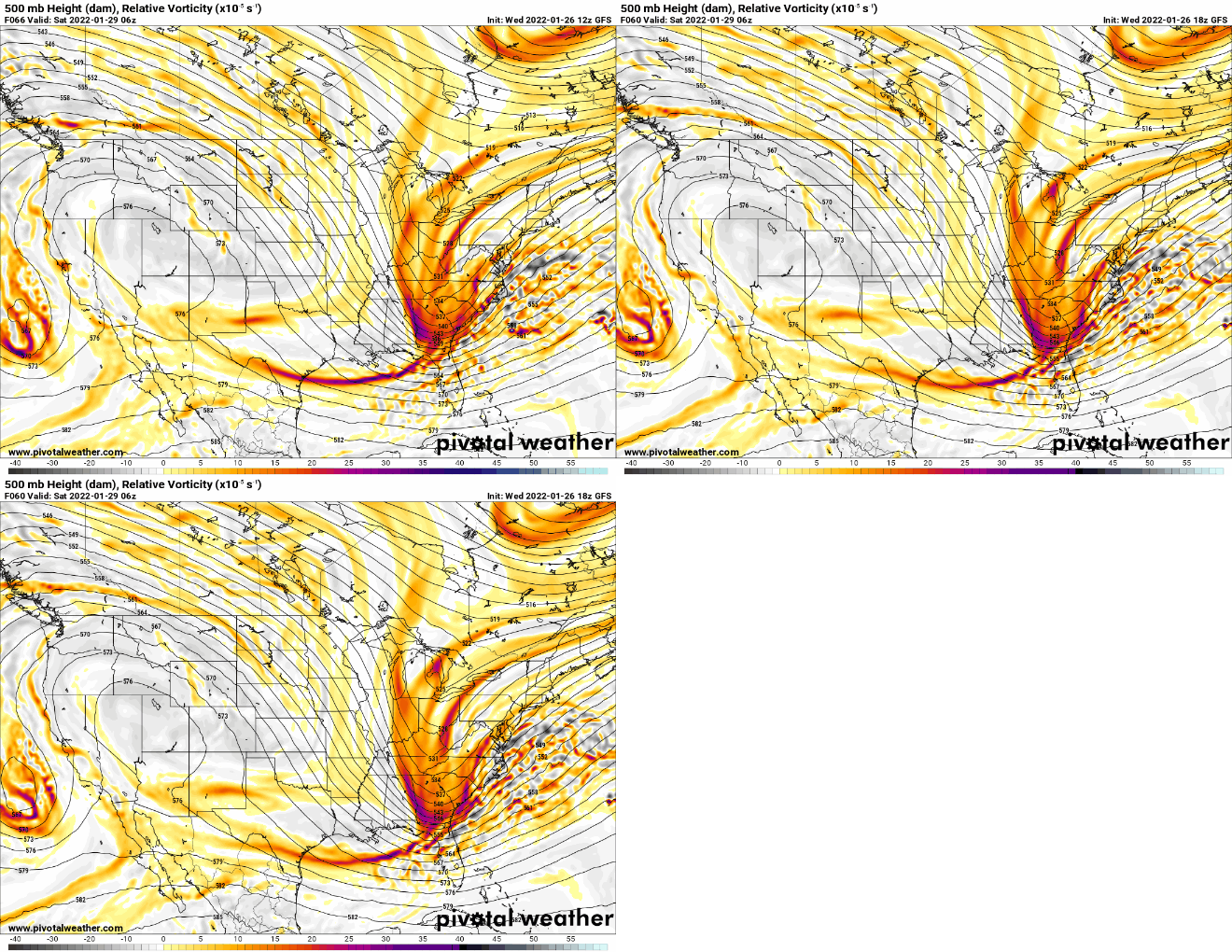
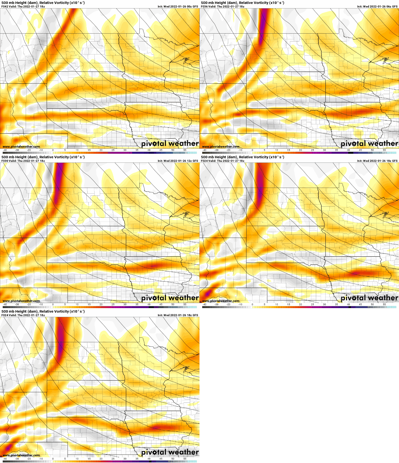
GFS last 4 run trend with the northern vort. Notice how it's getting sharper and sharper, pointing more south. Hmmmmmmm

_________________
_______________________________________________________________________________________________________
CLICK HERE to view NJ Strong Snowstorm Classifications
sroc4, heehaw453 and JT33 like this post
 Re: Tracking JAN 29th 2022 'The Phase'
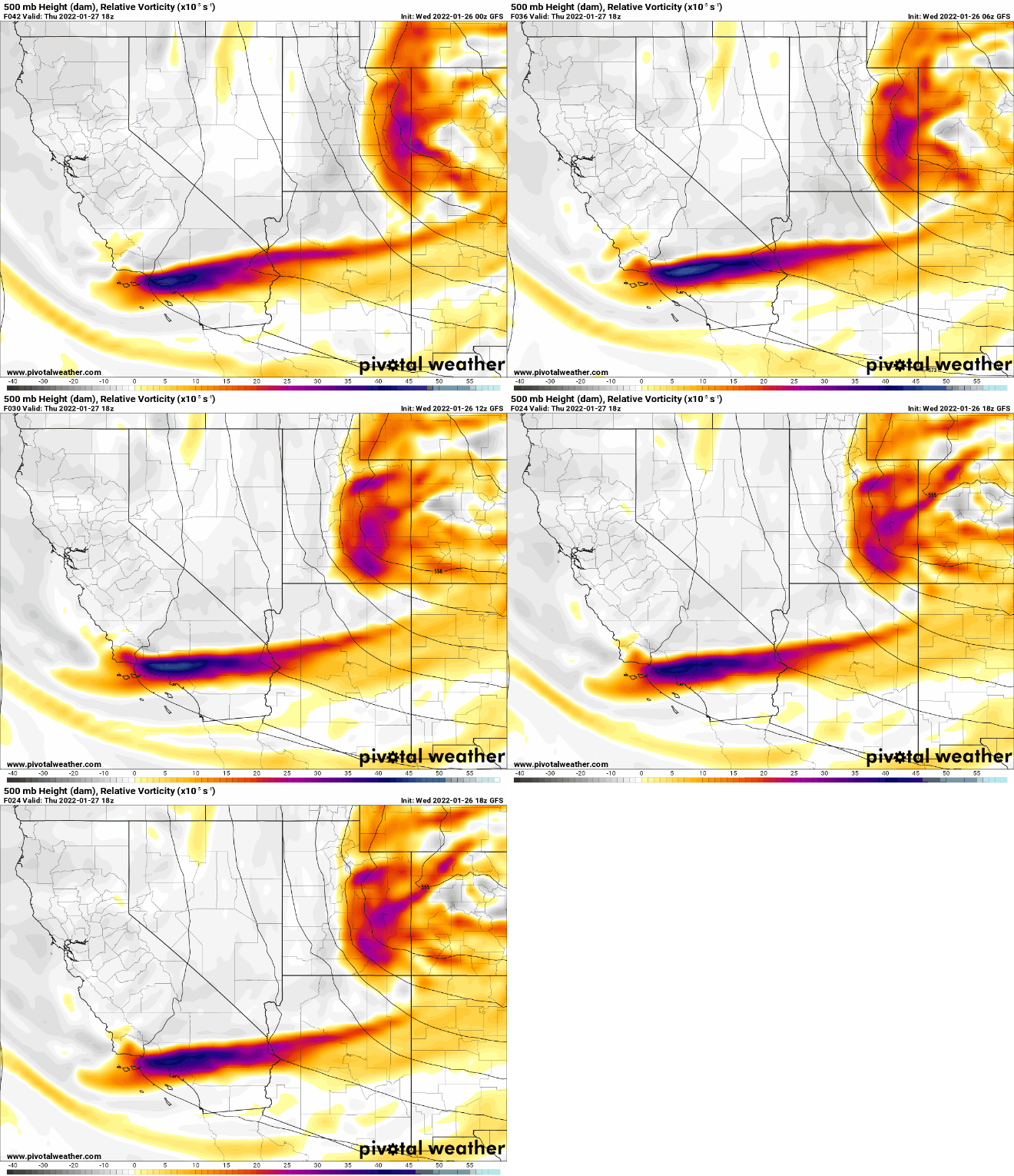
If we zoom in closer on the initial energy...looks like 18z GFS is trying to shift slightly east with it too. Not quite where 00z GFS was last night but at least we stopped it from going even more west.

_________________
_______________________________________________________________________________________________________
CLICK HERE to view NJ Strong Snowstorm Classifications
 Re: Tracking JAN 29th 2022 'The Phase'
I’ve not chimed in much because even though I’ve been following, I’ve not been intently studying. But from what I’ve seen of the pattern over and near North America, I cannot see this missing east. I honestly just can’t. Quite perplexing to say the least.
rb924119- Meteorologist

- Posts : 7033
Reputation : 195
Join date : 2013-02-06
Age : 32
Location : Greentown, Pa
SoulSingMG, jmanley32 and Irish like this post
 Re: Tracking JAN 29th 2022 'The Phase'
_________________
_______________________________________________________________________________________________________
CLICK HERE to view NJ Strong Snowstorm Classifications
Dunnzoo, essexcountypete, jmanley32, heehaw453, weatherwatchermom, Irish, phil155 and like this post
 Re: Tracking JAN 29th 2022 'The Phase'
rb924119 wrote:I’ve not chimed in much because even though I’ve been following, I’ve not been intently studying. But from what I’ve seen of the pattern over and near North America, I cannot see this missing east. I honestly just can’t. Quite perplexing to say the least.
I agree with that based on the ridge/trough axis. However, the closing off part is a wild card.
heehaw453- Advanced Forecaster

- Posts : 3908
Reputation : 86
Join date : 2014-01-20
Location : Bedminster Township, PA Elevation 600' ASL
 Re: Tracking JAN 29th 2022 'The Phase'
jmanley32 wrote:Is there any chance we go back to the heavy hits we saw and it happening or is that completely off the table and now just focusing on getting a 6 inch storm maybe for NYC? Seems there has just been too much model changes for that to be completely off the table yet, IMO.
For NYC IMO anywhere from 2" - 12"+ with this kind of setup. It's that reliant on this storm developing well.
heehaw453- Advanced Forecaster

- Posts : 3908
Reputation : 86
Join date : 2014-01-20
Location : Bedminster Township, PA Elevation 600' ASL
 Re: Tracking JAN 29th 2022 'The Phase'
Well then lol, so the two extremes are still plausible, crazy this is less than 48 hrs away. People are go be caught off guard if this gets reeled back in.heehaw453 wrote:jmanley32 wrote:Is there any chance we go back to the heavy hits we saw and it happening or is that completely off the table and now just focusing on getting a 6 inch storm maybe for NYC? Seems there has just been too much model changes for that to be completely off the table yet, IMO.
For NYC IMO anywhere from 2" - 12"+ with this kind of setup. It's that reliant on this storm developing well.

jmanley32- Senior Enthusiast

- Posts : 20635
Reputation : 108
Join date : 2013-12-12
Age : 43
Location : Yonkers, NY
heehaw453- Advanced Forecaster

- Posts : 3908
Reputation : 86
Join date : 2014-01-20
Location : Bedminster Township, PA Elevation 600' ASL
 Re: Tracking JAN 29th 2022 'The Phase'
When you say I 95 thats kinda confusing to me as it is right along the water, are you saying the general area like my area (NNJ, southern westchester NYC CT, RI etc? I have always wondered what ythe borderlines of _95 area exactly when it comes to weather.

jmanley32- Senior Enthusiast

- Posts : 20635
Reputation : 108
Join date : 2013-12-12
Age : 43
Location : Yonkers, NY
 Re: Tracking JAN 29th 2022 'The Phase'
That totally looks gorgeous, I can't see a miss with that either, too many times when I have seen that look we have had a blockbuster storm. lets hope the LR models just never got this and the 18z NAM was just a fluke and the other SR models which will really start to be in range tonight and tomorrow show the juju.

jmanley32- Senior Enthusiast

- Posts : 20635
Reputation : 108
Join date : 2013-12-12
Age : 43
Location : Yonkers, NY
 Re: Tracking JAN 29th 2022 'The Phase'
jmanley32 wrote:When you say I 95 thats kinda confusing to me as it is right along the water, are you saying the general area like my area (NNJ, southern westchester NYC CT, RI etc? I have always wondered what ythe borderlines of _95 area exactly when it comes to weather.
I'm saying from PHL-NYC points east that looks like a major snowfall.
heehaw453- Advanced Forecaster

- Posts : 3908
Reputation : 86
Join date : 2014-01-20
Location : Bedminster Township, PA Elevation 600' ASL
Page 9 of 31 •  1 ... 6 ... 8, 9, 10 ... 20 ... 31
Page 9 of 31
Permissions in this forum:
You cannot reply to topics in this forum|
|
|

 Home
Home