Long Range Thread 28.0
Page 5 of 18 •  1, 2, 3, 4, 5, 6 ... 11 ... 18
 Re: Long Range Thread 28.0
As Damien said" Can't catch a break!!"
3.4
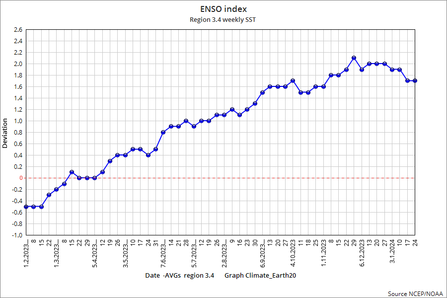
1.2 All but gone
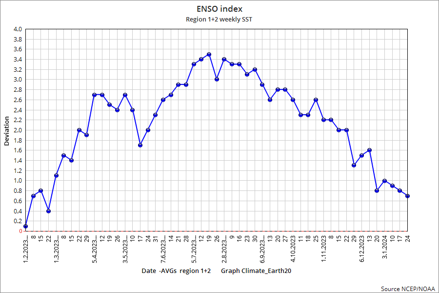
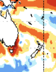
This is very interesting and what screwed up (kind language here) our winter in January!!! The massive warming of the Pac off the East Coast of Australia that promoted the phase of the MJO going to 4,5,6 - ARGGHH! - AGAIN CAN'T FRIGGING WIN....NOT ONE , ONE MODEL SAW THIS OR HAD THIS EVEN THORUGH DEC!!!!!
Predictions in Nov by Euro Seasonal Forecast SST
.png)
Close Up
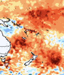
What happened - REALLY?? One explanation is the uptick in underwater, submarine level volcanoes as JB points out
.png)
CLOSE UP
amugs- Advanced Forecaster - Mod

- Posts : 15095
Join date : 2013-01-07
sroc4 likes this post
 Re: Long Range Thread 28.0
dkodgis- Senior Enthusiast

- Posts : 2560
Join date : 2013-12-29
Frank_Wx, sroc4, docstox12, CPcantmeasuresnow, Grselig and billg315 like this post
 Re: Long Range Thread 28.0
I will say though - the period after Feb 10th looks exciting. There is a lot to like on long range guidance right now. I couldn’t say the same this time last week.
The emergence of the -EPO and -NAO should lead to at least 2 if not 3 storm chances in the mid Feb time frame. Maybe with El Niño weakening - as Mugs pointed out - we will find more natural phasing between the northern and southern branches. One can hope!
_________________
_______________________________________________________________________________________________________
CLICK HERE to view NJ Strong Snowstorm Classifications
docstox12, amugs, kalleg, Grselig, crippo84, billg315, SENJsnowman and like this post
 Re: Long Range Thread 28.0
heehaw453- Advanced Forecaster

- Posts : 3906
Reputation : 86
Join date : 2014-01-20
Location : Bedminster Township, PA Elevation 600' ASL
 Re: Long Range Thread 28.0
heehaw453- Advanced Forecaster

- Posts : 3906
Reputation : 86
Join date : 2014-01-20
Location : Bedminster Township, PA Elevation 600' ASL
 Re: Long Range Thread 28.0
Since Heehaw mentioned Cape Cod…
https://youtu.be/nLClv1i_SLc?feature=shared

dkodgis- Senior Enthusiast

- Posts : 2560
Reputation : 98
Join date : 2013-12-29
docstox12 and heehaw453 like this post
 Re: Long Range Thread 28.0
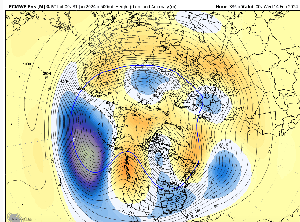
If the EURO Ensembles are anywhere near accurate - this will be the most prolific western ridging we have seen YET this winter (+PNA/-EPO). It's pointed polewards, the axis is favorably positioned, and it disrupts the PV (-AO) to force a trough over the eastern CONUS. Madonne, this is gorgeous gorgeous gorgeous look.

_________________
_______________________________________________________________________________________________________
CLICK HERE to view NJ Strong Snowstorm Classifications
sroc4, amugs, nancy-j-s, dolphins222, MattyICE and phil155 like this post
 Re: Long Range Thread 28.0
Frank_Wx wrote:Models are beginning to hone in on our next real chance for snow. February 12th-15th.
If the EURO Ensembles are anywhere near accurate - this will be the most prolific western ridging we have seen YET this winter (+PNA/-EPO). It's pointed polewards, the axis is favorably positioned, and it disrupts the PV (-AO) to force a trough over the eastern CONUS. Madonne, this is gorgeous gorgeous gorgeous look.
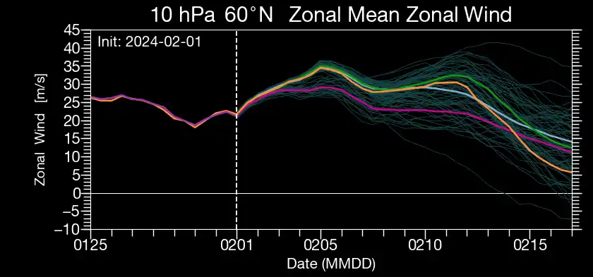
Couldn't agree more Frank. It's what winter weather weenie's dreams are made out of. GEFS have the same idea. As of now it's in fantasy/dream land, BUT I will say there is a lot to like between the SOI, MJO progression, Strat changes (both current and forecasted changes), weakening El Nino etc that support this look to develop. Cautious optimism needed for sure.

Last edited by sroc4 on Thu Feb 01, 2024 11:08 am; edited 1 time in total
_________________
"In weather and in life, there's no winning and losing; there's only winning and learning."
WINTER 2012/2013 TOTALS 43.65"WINTER 2017/2018 TOTALS 62.85" WINTER 2022/2023 TOTALS 4.9"
WINTER 2013/2014 TOTALS 64.85"WINTER 2018/2019 TOTALS 14.25" WINTER 2023/2024 TOTALS 13.1"
WINTER 2014/2015 TOTALS 71.20"WINTER 2019/2020 TOTALS 6.35"
WINTER 2015/2016 TOTALS 35.00"WINTER 2020/2021 TOTALS 37.75"
WINTER 2016/2017 TOTALS 42.25"WINTER 2021/2022 TOTALS 31.65"

sroc4- Admin

- Posts : 8354
Reputation : 302
Join date : 2013-01-07
Location : Wading River, LI
Frank_Wx and nancy-j-s like this post
 Re: Long Range Thread 28.0

billg315- Advanced Forecaster - Mod

- Posts : 4483
Reputation : 185
Join date : 2015-01-24
Age : 50
Location : Flemington, NJ
sroc4 likes this post
 Re: Long Range Thread 28.0
Koroptim- Posts : 29
Reputation : 0
Join date : 2013-01-16
sroc4 and SENJsnowman like this post
 Re: Long Range Thread 28.0
Koroptim wrote:I’ve followed Joe B for a long time. He takes a lot of heat for being snow biased, but I think that is overdone. Anyway, I’ve rarely seen him as bullish and excited as he is about the Feb15-Mar15 timeframe.
Same exact thing with NorEasterNick who covers Southern Jersey and the Philly metro area. Well, actually, he usually downplays snow potential for his coverage area but he said two months ago he liked the potential of the second half of this winter A LOT more than the first half. And now he is beyond excited for the same time frame, Feb 15-March 15.
And all week he has been saying to be patient…and I quote to “trust the process”. Hmmm…that sounds familiar! lol. Speaking of which, what say you RB-wan-Kenobe?
SENJsnowman- Senior Enthusiast

- Posts : 1189
Reputation : 61
Join date : 2017-01-06
Age : 51
Location : Bayville, NJ
Koroptim and phil155 like this post
 Re: Long Range Thread 28.0
SENJsnowman wrote:Koroptim wrote:I’ve followed Joe B for a long time. He takes a lot of heat for being snow biased, but I think that is overdone. Anyway, I’ve rarely seen him as bullish and excited as he is about the Feb15-Mar15 timeframe.
Same exact thing with NorEasterNick who covers Southern Jersey and the Philly metro area. Well, actually, he usually downplays snow potential for his coverage area but he said two months ago he liked the potential of the second half of this winter A LOT more than the first half. And now he is beyond excited for the same time frame, Feb 15-March 15.
And all week he has been saying to be patient…and I quote to “trust the process”. Hmmm…that sounds familiar! lol. Speaking of which, what say you RB-wan-Kenobe?
Bobby at EPWA is more bullish on this time period as well and has been for a while. Granted most of us are pretty far behind in terms of snow bur it would really only take one good storm and from the sounds of what these folks are saying we are Bout 2 weeks from go time.
phil155- Pro Enthusiast

- Posts : 483
Reputation : 4
Join date : 2019-12-16
SENJsnowman likes this post
 Re: Long Range Thread 28.0
One of the most notable features appearing on consecutive ECMWF Weeklies runs is the presence of a retrograding Greenland block in tandem with ridging into the Arctic Ocean. These two features coexisting can lead to prolonged periods of cold, stormy weather in the US and Europe. pic.twitter.com/nztTllZhhg
— John Homenuk (@jhomenuk) February 2, 2024
_________________
Mugs
AKA:King: Snow Weenie
Self Proclaimed
WINTER 2014-15 : 55.12" +.02 for 6 coatings (avg. 35")
WINTER 2015-16 Total - 29.8" (Avg 35")
WINTER 2016-17 : 39.5" so far

amugs- Advanced Forecaster - Mod

- Posts : 15095
Reputation : 213
Join date : 2013-01-07
Age : 54
Location : Hillsdale,NJ
 Re: Long Range Thread 28.0
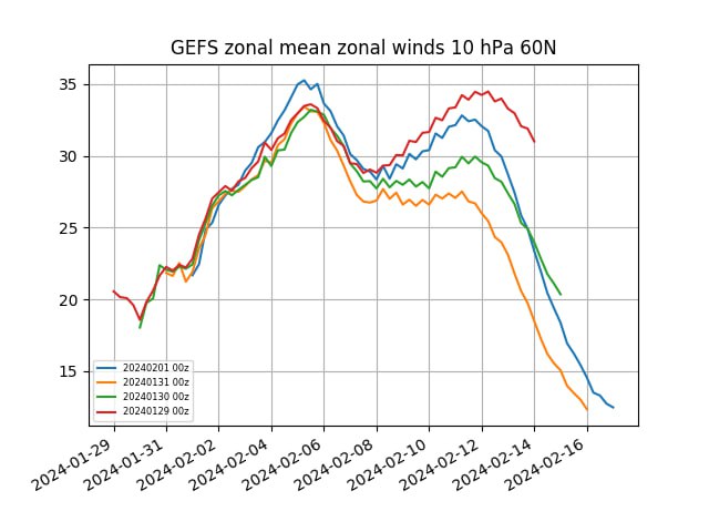
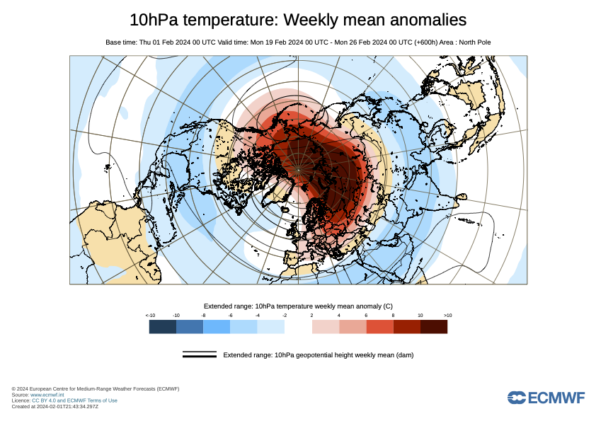
BIGLY strat warming
_________________
Mugs
AKA:King: Snow Weenie
Self Proclaimed
WINTER 2014-15 : 55.12" +.02 for 6 coatings (avg. 35")
WINTER 2015-16 Total - 29.8" (Avg 35")
WINTER 2016-17 : 39.5" so far

amugs- Advanced Forecaster - Mod

- Posts : 15095
Reputation : 213
Join date : 2013-01-07
Age : 54
Location : Hillsdale,NJ
Grselig likes this post
 Re: Long Range Thread 28.0
frank 638- Senior Enthusiast

- Posts : 2843
Reputation : 37
Join date : 2016-01-01
Age : 40
Location : bronx ny
 Re: Long Range Thread 28.0
The Greatest SOI crash in Feb since 1978 is evolving A sign the MJO is on the move. The positive helped return us to a La Nina base state for a couple of weeks and there is a delay. But now here comes the crash. Here is the temp for these years with such and Mod to Strong El Nino.
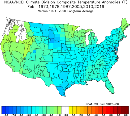
I have to say if this doesn't pan out in the next two weeks pattern wise this winter goes down up there with last winter. Time will tell.
_________________
Mugs
AKA:King: Snow Weenie
Self Proclaimed
WINTER 2014-15 : 55.12" +.02 for 6 coatings (avg. 35")
WINTER 2015-16 Total - 29.8" (Avg 35")
WINTER 2016-17 : 39.5" so far

amugs- Advanced Forecaster - Mod

- Posts : 15095
Reputation : 213
Join date : 2013-01-07
Age : 54
Location : Hillsdale,NJ
 Re: Long Range Thread 28.0
frank 638 wrote:Amugs last night Lee Goldberg was saying a pattern change is coming from Feb 15 to march 15 th to a colder and possibly of a snowy pattern ! What do you think of this
From what I am seeing on Chi200 Velocity maps and Strat maps he stole exactly what we've said here for the past few days LOL!
IF it doesn't happen we blame him and the rest of the pro mets who MUSH every storm since 2011
_________________
Mugs
AKA:King: Snow Weenie
Self Proclaimed
WINTER 2014-15 : 55.12" +.02 for 6 coatings (avg. 35")
WINTER 2015-16 Total - 29.8" (Avg 35")
WINTER 2016-17 : 39.5" so far

amugs- Advanced Forecaster - Mod

- Posts : 15095
Reputation : 213
Join date : 2013-01-07
Age : 54
Location : Hillsdale,NJ
 Re: Long Range Thread 28.0
https://youtu.be/SdhAfMor9BM?feature=shared

dkodgis- Senior Enthusiast

- Posts : 2560
Reputation : 98
Join date : 2013-12-29
Frank_Wx likes this post
 Re: Long Range Thread 28.0
The long wave pattern has been consistently advertised and has great consensus. It's coming. Before that though the Omega block is going to hurt snowfall twice 1/it suppresses a major snow storm on the 5th, 2/its corresponding ridge will pass over the area next weekend and cause a warm air mass.
Now how long does it take the airmass to get suitable for snow? Interior is favored until that happens. My guess after 2/17ish coastal plain is in the game. I think 2/12-16 interior is favored. Next is how long does the great long wave pattern last? I wouldn't go anymore than 10 days for starters. It could be more and spill into March, but that call is bold right now. We don't have enough data to suggest blocking sets up shop a la March 2018.
I would expect in the next week models start picking up on this and you start to see some interesting digital snowfall maps.

heehaw453- Advanced Forecaster

- Posts : 3906
Reputation : 86
Join date : 2014-01-20
Location : Bedminster Township, PA Elevation 600' ASL
 Re: Long Range Thread 28.0
AO & NAO goes N which allows cold air to filter down


PNA goes Positive again around the 12th - coincide with Hee Sweatheart Storm??

EPO goes N around the 12/13th which when it does it can drill the cold polar flow in from Siberia aka the Siberian Express.

Time will tell ......only 10 days away as per the usual!
VERY LR - Hcane season maybe one the worst, active since 2017, 2005 as per analog charts, maps and SST forecasts.
One thing to note from just listening to JB and dawned on me that is staring us right in the face, the PAC SST are and have been since the Godzilla El Nino in 2015-16 on Fire and have had very little let up. Even going back to the 97-98 EL Nino the oceans have warmed greatly. SO when we get the PAC JET extension going this has been MUCH warmer than in the past due to the SST being AN. Food for thought. This coincide nicely with the Solar Max over the last 40 years so far
_________________
Mugs
AKA:King: Snow Weenie
Self Proclaimed
WINTER 2014-15 : 55.12" +.02 for 6 coatings (avg. 35")
WINTER 2015-16 Total - 29.8" (Avg 35")
WINTER 2016-17 : 39.5" so far

amugs- Advanced Forecaster - Mod

- Posts : 15095
Reputation : 213
Join date : 2013-01-07
Age : 54
Location : Hillsdale,NJ
heehaw453 likes this post
 Re: Long Range Thread 28.0

heehaw453- Advanced Forecaster

- Posts : 3906
Reputation : 86
Join date : 2014-01-20
Location : Bedminster Township, PA Elevation 600' ASL
JT33 likes this post
 Re: Long Range Thread 28.0
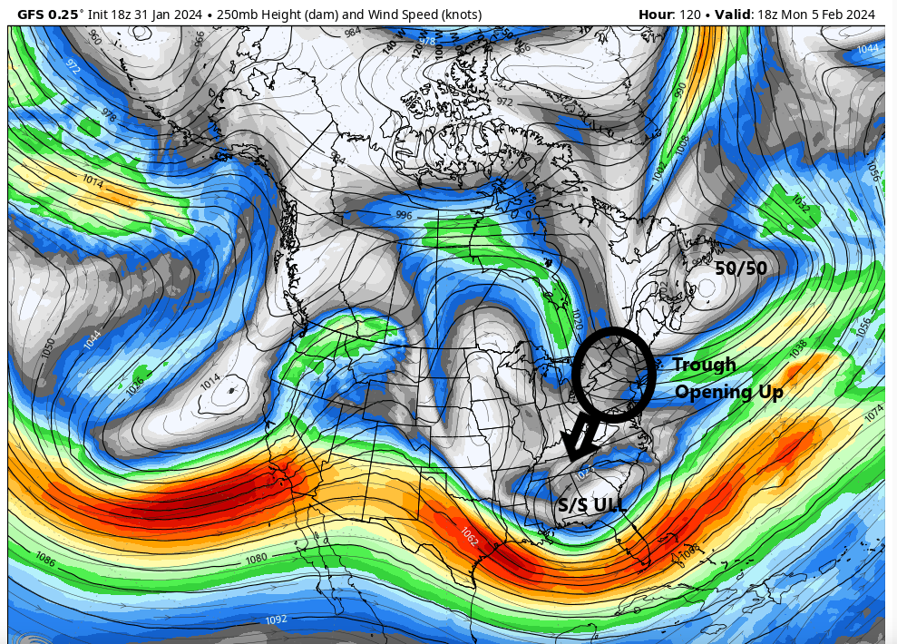
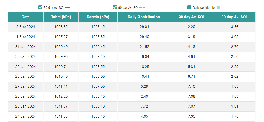
heehaw453 wrote:Looking at the upper jet stream and I start to see it buckle in Southern CA that tells me abundant moisture is going to be pumped into the EC via STJ and colder air will spill into the lower 48 as the jet is far enough south. It makes sense if you look at the southern oscillation index values too. The split flow shown can allow for n/s enhancement to a developing storm. As I stated before there will be parts of the EC that are sig AN snowfall this month. Cannot imagine this gets anywhere near 2010, but folks hoping for double digits second half of February would seem reasonable based on what I see at least. Yes that's normal for many but "normal" varies quite a bit year to year.
Wow. Look at that textbook split flow out west. Beautiful.
MattyICE- Advanced Forecaster

- Posts : 249
Reputation : 6
Join date : 2017-11-10
Age : 38
Location : Clifton, NJ (Eastern Passaic County)
nancy-j-s and heehaw453 like this post
 Re: Long Range Thread 28.0
If it comes through to full fruition you see something like this maybe once in ten years. Maybe. Also of note is the EPS and other guidance is throwing a strong signal for intense HL blocking. That kind of blocking as it links with Scandy ridge doesn't go anywhere fast. It sits and grows and retrogrades. 10 days minimum if that block swells like that.
I still am keeping my expectations at normal monthly snowfall due to losing half the month and the chaos of weather. But if this does align then believe you me that will bust low.


heehaw453- Advanced Forecaster

- Posts : 3906
Reputation : 86
Join date : 2014-01-20
Location : Bedminster Township, PA Elevation 600' ASL
weatherwatchermom, SENJsnowman, MattyICE and Irish like this post
 Re: Long Range Thread 28.0
_________________
"In weather and in life, there's no winning and losing; there's only winning and learning."
WINTER 2012/2013 TOTALS 43.65"WINTER 2017/2018 TOTALS 62.85" WINTER 2022/2023 TOTALS 4.9"
WINTER 2013/2014 TOTALS 64.85"WINTER 2018/2019 TOTALS 14.25" WINTER 2023/2024 TOTALS 13.1"
WINTER 2014/2015 TOTALS 71.20"WINTER 2019/2020 TOTALS 6.35"
WINTER 2015/2016 TOTALS 35.00"WINTER 2020/2021 TOTALS 37.75"
WINTER 2016/2017 TOTALS 42.25"WINTER 2021/2022 TOTALS 31.65"

sroc4- Admin

- Posts : 8354
Reputation : 302
Join date : 2013-01-07
Location : Wading River, LI
heehaw453 and MattyICE like this post
 Re: Long Range Thread 28.0
I am very pleasantly surprised that everywhere I look, meteorologists and avid weather birds seem to be universally agreeing that mid-Feb into mid-March the stars are aligned for big changes, cold temps, and snow.
Even Fidel Castro couldn’t get these pluralities.

dkodgis- Senior Enthusiast

- Posts : 2560
Reputation : 98
Join date : 2013-12-29
docstox12, CPcantmeasuresnow, weatherwatchermom and phil155 like this post
 Re: Long Range Thread 28.0
I've noticed the same thing with these 2 week in the future pattern changes. When everyone's all in the pattern never seems to change or if it does it's transient, a week or less. Just a weather hardened skeptics view.
As always I'd love to be proven wrong.

CPcantmeasuresnow- Wx Statistician Guru

- Posts : 7274
Reputation : 230
Join date : 2013-01-07
Age : 103
Location : Eastern Orange County, NY
docstox12, dkodgis, Sparky Sparticles and GreyBeard like this post
 Re: Long Range Thread 28.0
Well said. We can't predict what a storm that's 36-48 hours out will do. How the hell can we expect to believe in overhaul changes in the pattern that are 2 weeks out?CPcantmeasuresnow wrote:The stock market always crashes when everyone is all in on buying.
I've noticed the same thing with these 2 week in the future pattern changes. When everyone's all in the pattern never seems to change or if it does it's transient, a week or less. Just a weather hardened skeptics view.
As always I'd love to be proven wrong.

Irish- Pro Enthusiast

- Posts : 788
Reputation : 19
Join date : 2019-01-16
Age : 45
Location : Old Bridge, NJ
docstox12, dkodgis and GreyBeard like this post
Page 5 of 18 •  1, 2, 3, 4, 5, 6 ... 11 ... 18
|
|
|

 Home
Home