February 12th-13th 2024 Pre-Valentines Day Storm Potential
+31
richb521
brownie
Carvin
silentwreck
dkodgis
NJBear
essexcountypete
amugs
tomsriversnowstorm
aiannone
SENJsnowman
jmanley32
nutleyblizzard
dsix85
docstox12
toople
Irish
Dunnzoo
Koroptim
phil155
Frank_Wx
MattyICE
billg315
frank 638
hyde345
SNOW MAN
Artechmetals
CPcantmeasuresnow
heehaw453
JT33
sroc4
35 posters
Page 4 of 13
Page 4 of 13 •  1, 2, 3, 4, 5 ... 11, 12, 13
 Re: February 12th-13th 2024 Pre-Valentines Day Storm Potential
This n/s wild card has sucked me back in. 
heehaw453- Advanced Forecaster

- Posts : 3906
Join date : 2014-01-20
weatherwatchermom and SENJsnowman like this post
 Re: February 12th-13th 2024 Pre-Valentines Day Storm Potential
know its impossible to know where ccb sets up but does it have any chsnce to be nj to nyc and ne?heehaw453 wrote:sroc4 wrote:There is clearly a tick south with all of the 12z runs. GEFS as well. Will be interesting to see if overnight we cont to tick south vs windshield wiper back north. Yeah. With the depth of cold to our north a colder soln wouldn’t surprise me. But with trends this winter neither would the warmer soln.
Agree 100%. I see a CCB feature developing on this. There's evidence of an h5 close off too before it gets to the coast. That consolidation would further support a colder scenario. Going to be close. Expectations in check.
jmanley32- Senior Enthusiast

- Posts : 20535
Join date : 2013-12-12
 Re: February 12th-13th 2024 Pre-Valentines Day Storm Potential
i can see that u were stead fast on it not work out for coastal areas like my area now if nam is right ill see a wsw if i can get a high end wwa ill b okay with it. Honestly its pretty to watch but getting over 6 is when the real shoveling and street parking sucks. I must be getting old to be talking myself down from a big snowstorm lolheehaw453 wrote:This n/s wild card has sucked me back in.

jmanley32- Senior Enthusiast

- Posts : 20535
Reputation : 108
Join date : 2013-12-12
Age : 43
Location : Yonkers, NY
billg315 likes this post
 Re: February 12th-13th 2024 Pre-Valentines Day Storm Potential
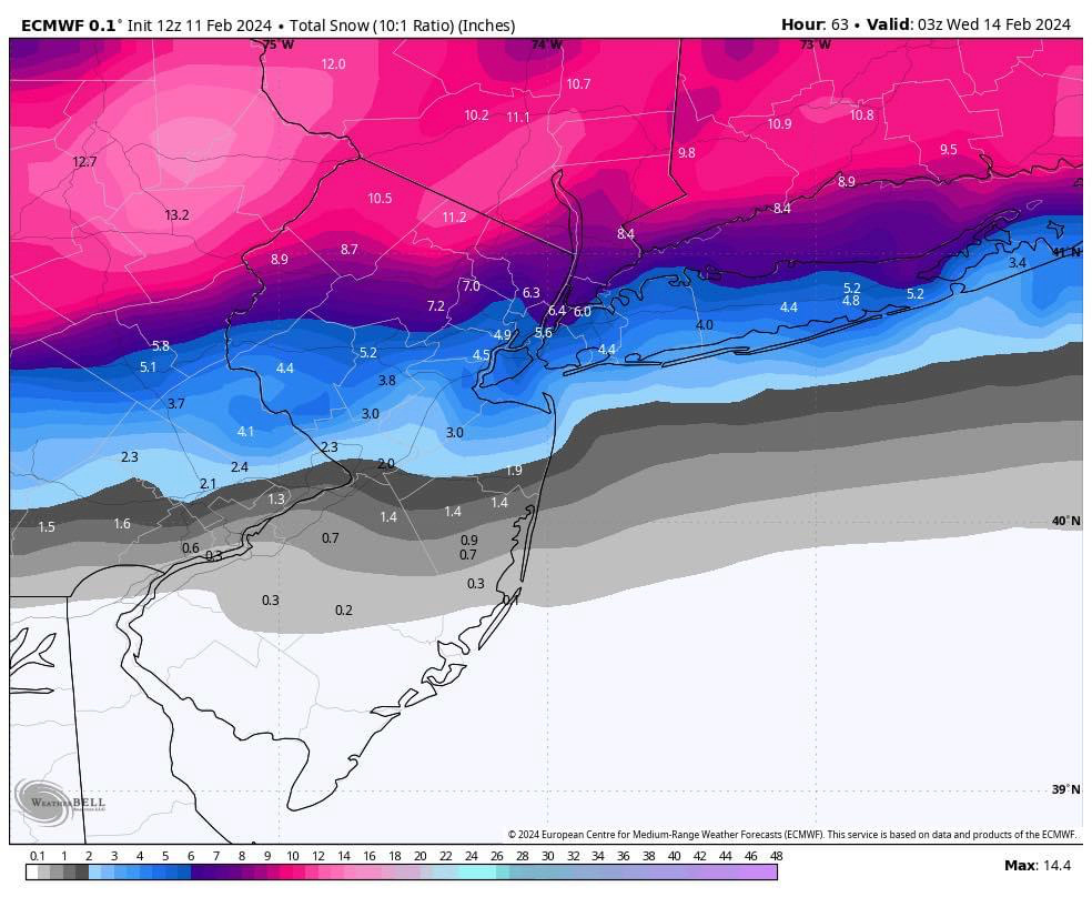
12z Euro rolling. Looks like this might be a positive trender as well - also a tick south? Let’s see.

billg315- Advanced Forecaster - Mod

- Posts : 4483
Reputation : 185
Join date : 2015-01-24
Age : 50
Location : Flemington, NJ
silentwreck likes this post
 Re: February 12th-13th 2024 Pre-Valentines Day Storm Potential
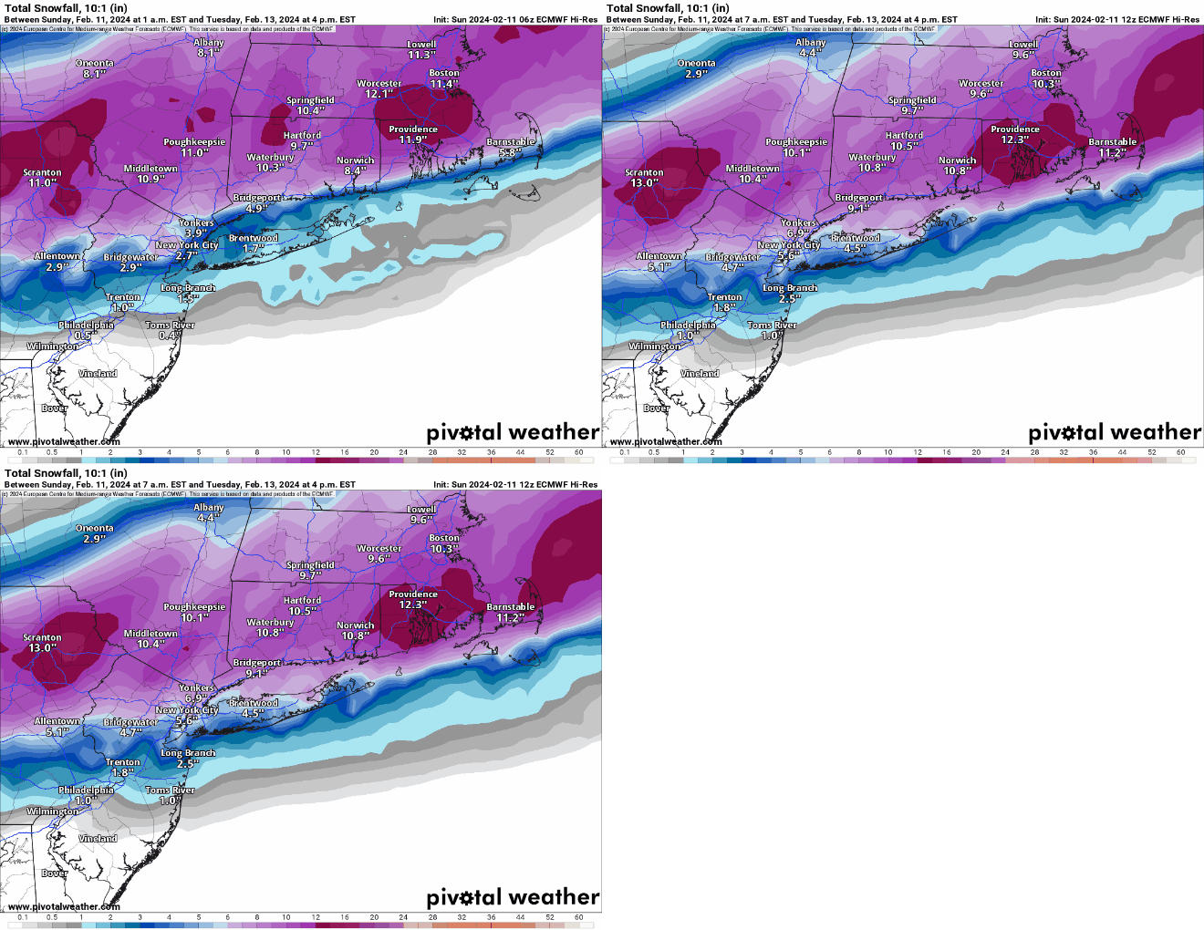
12z Euro is a positive trend also. Not a big difference but noticeable improvement on southern cutoff location for measurable snow. I’ll take it. Especially since it is now joining positive trends on the other 12z models.

billg315- Advanced Forecaster - Mod

- Posts : 4483
Reputation : 185
Join date : 2015-01-24
Age : 50
Location : Flemington, NJ
 Re: February 12th-13th 2024 Pre-Valentines Day Storm Potential
Quite a jump south in the 12z suite. Euro is most notable
_________________
-Alex Iannone-

aiannone- Senior Enthusiast - Mod

- Posts : 4815
Reputation : 92
Join date : 2013-01-07
Location : Saint James, LI (Northwest Suffolk Co.)

aiannone- Senior Enthusiast - Mod

- Posts : 4815
Reputation : 92
Join date : 2013-01-07
Location : Saint James, LI (Northwest Suffolk Co.)
jmanley32 and silentwreck like this post
 Re: February 12th-13th 2024 Pre-Valentines Day Storm Potential
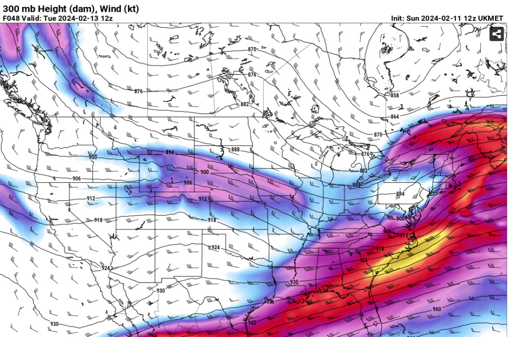
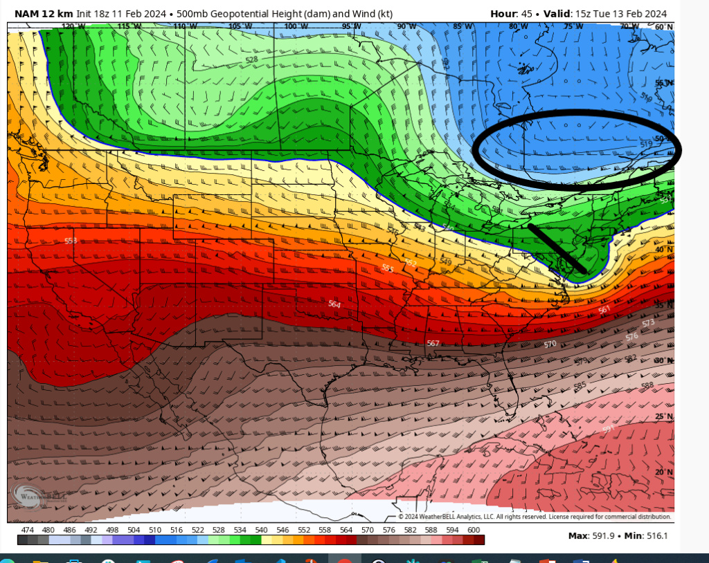
12Z Euro has this n/s piece even more pronounced (1st pic).
How quickly does this n/s piece move east? It will intensify the storm rapidly and cool the mid-levels. Note the progression of the 850's (second pic) is more toward Mason Dixon Line. Would love to see it south of there. 45 hours folks nothing is set in stone.

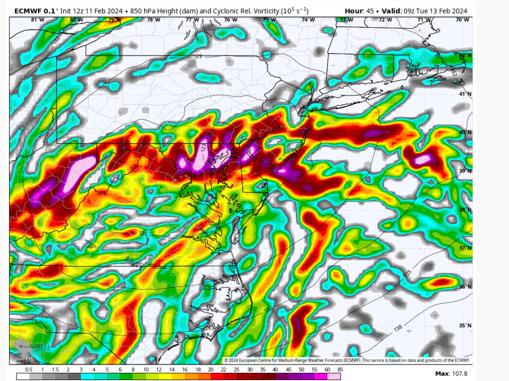
How quickly does this n/s piece move east? It will intensify the storm rapidly and cool the mid-levels. Note the progression of the 850's (second pic) is more toward Mason Dixon Line. Would love to see it south of there. 45 hours folks nothing is set in stone.


heehaw453- Advanced Forecaster

- Posts : 3906
Reputation : 86
Join date : 2014-01-20
Location : Bedminster Township, PA Elevation 600' ASL
silentwreck likes this post
 Re: February 12th-13th 2024 Pre-Valentines Day Storm Potential
jmanley32 wrote:i can see that u were stead fast on it not work out for coastal areas like my area now if nam is right ill see a wsw if i can get a high end wwa ill b okay with it. Honestly its pretty to watch but getting over 6 is when the real shoveling and street parking sucks. I must be getting old to be talking myself down from a big snowstorm lolheehaw453 wrote:This n/s wild card has sucked me back in.
If it bombs and stays far enough south your area will be 4-6" with possibly more.
heehaw453- Advanced Forecaster

- Posts : 3906
Reputation : 86
Join date : 2014-01-20
Location : Bedminster Township, PA Elevation 600' ASL
jmanley32 and MattyICE like this post

nutleyblizzard- Senior Enthusiast

- Posts : 1954
Reputation : 41
Join date : 2014-01-30
Age : 58
Location : Nutley, new jersey
 Re: February 12th-13th 2024 Pre-Valentines Day Storm Potential
jmanley32 wrote:what do you think are the chances southern westchester, which is due east across the hudson from NE NJ is able to get a warning level snow? Rn like zoo said not even a hwo. Shes prolly right that nws isnt sure but its odd that there isnt even a hwo suggesting snow is even a possibility. Verbatim that nsm run gives me 6 to 8 but is there any confidence on that at all. Hate these razor shap cut off storms. Os it possible it slips further south?nutleyblizzard wrote:12zNam looks great for northern half of NJ. Widespread warning criteria snows.MattyICE wrote:NE NJ certainly not likely to be in any more than an advisory unless there are shifts.
Per Bernie Rayno a few minutes ago...
"One consistent theme I have seem by looking at the soundings is how tricky this from southern RI/ CT to the northern suburbs of NYC. temps from 850 mb to near the surface is right along the freezing line into Tue am resulting in mixing. North of there, cold enough for just snow."
_________________
Janet
Snowfall winter of 2023-2024 17.5"
Snowfall winter of 2022-2023 6.0"
Snowfall winter of 2021-2022 17.6" 1" sleet 2/25/22
Snowfall winter of 2020-2021 51.1"
Snowfall winter of 2019-2020 8.5"
Snowfall winter of 2018-2019 25.1"
Snowfall winter of 2017-2018 51.9"
Snowfall winter of 2016-2017 45.6"
Snowfall winter of 2015-2016 29.5"
Snowfall winter of 2014-2015 50.55"
Snowfall winter of 2013-2014 66.5"
Dunnzoo- Senior Enthusiast - Mod

- Posts : 4905
Reputation : 68
Join date : 2013-01-11
Age : 62
Location : Westwood, NJ
heehaw453- Advanced Forecaster

- Posts : 3906
Reputation : 86
Join date : 2014-01-20
Location : Bedminster Township, PA Elevation 600' ASL
MattyICE- Advanced Forecaster

- Posts : 249
Reputation : 6
Join date : 2017-11-10
Age : 38
Location : Clifton, NJ (Eastern Passaic County)
kalleg likes this post

nutleyblizzard- Senior Enthusiast

- Posts : 1954
Reputation : 41
Join date : 2014-01-30
Age : 58
Location : Nutley, new jersey
 Re: February 12th-13th 2024 Pre-Valentines Day Storm Potential
_________________
-Alex Iannone-

aiannone- Senior Enthusiast - Mod

- Posts : 4815
Reputation : 92
Join date : 2013-01-07
Location : Saint James, LI (Northwest Suffolk Co.)
silentwreck likes this post
 Re: February 12th-13th 2024 Pre-Valentines Day Storm Potential
_________________
-Alex Iannone-

aiannone- Senior Enthusiast - Mod

- Posts : 4815
Reputation : 92
Join date : 2013-01-07
Location : Saint James, LI (Northwest Suffolk Co.)
kalleg, jmanley32 and silentwreck like this post
 Re: February 12th-13th 2024 Pre-Valentines Day Storm Potential
Still looking at 18z NAM as it comes in, but the map Alex posted is consistent with what I'm seeing. Another move south with the snow for the second straight run.

billg315- Advanced Forecaster - Mod

- Posts : 4483
Reputation : 185
Join date : 2015-01-24
Age : 50
Location : Flemington, NJ

aiannone- Senior Enthusiast - Mod

- Posts : 4815
Reputation : 92
Join date : 2013-01-07
Location : Saint James, LI (Northwest Suffolk Co.)
heehaw453- Advanced Forecaster

- Posts : 3906
Reputation : 86
Join date : 2014-01-20
Location : Bedminster Township, PA Elevation 600' ASL
 Re: February 12th-13th 2024 Pre-Valentines Day Storm Potential
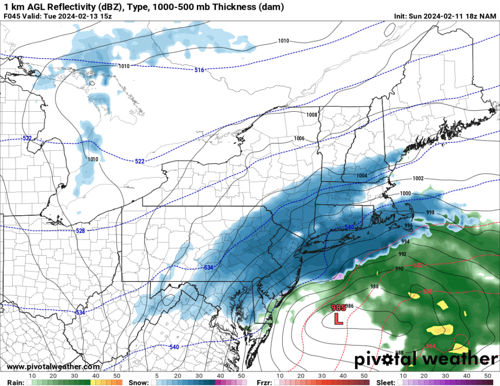
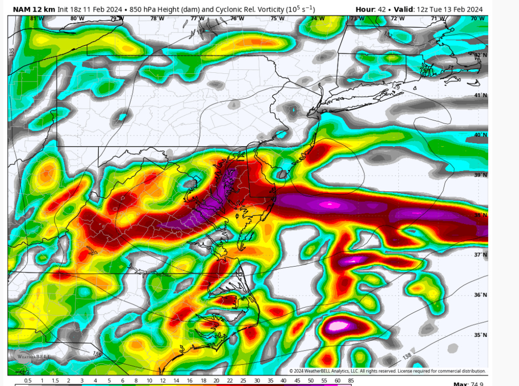
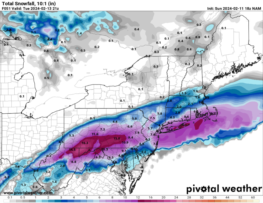
18z NAM: Cold press to the North is more stout; Storm is further south coming out of the Tennessee Valley; 850s are colder further south; 850s below 0*C all the way down to the South Jersey coast early Tuesday AM; H5 energy is further south and comes off the coast at southern tip of Delmarva (last run was off Delaware proper near Cape May).
This run would move axis of heavy snow south of last couple runs for sure.
This run would move axis of heavy snow south of last couple runs for sure.

billg315- Advanced Forecaster - Mod

- Posts : 4483
Reputation : 185
Join date : 2015-01-24
Age : 50
Location : Flemington, NJ

aiannone- Senior Enthusiast - Mod

- Posts : 4815
Reputation : 92
Join date : 2013-01-07
Location : Saint James, LI (Northwest Suffolk Co.)
heehaw453- Advanced Forecaster

- Posts : 3906
Reputation : 86
Join date : 2014-01-20
Location : Bedminster Township, PA Elevation 600' ASL

billg315- Advanced Forecaster - Mod

- Posts : 4483
Reputation : 185
Join date : 2015-01-24
Age : 50
Location : Flemington, NJ
 Re: February 12th-13th 2024 Pre-Valentines Day Storm Potential
Can we trust the nam model? Especially with the euro and gfs being different? Is the nam usually correct or incorrect?
tomsriversnowstorm- Posts : 90
Reputation : 0
Join date : 2021-02-06
 Re: February 12th-13th 2024 Pre-Valentines Day Storm Potential
I would not read too much into the 18z NAM snow map verbatim. What's more important is that the dynamics are going colder, stronger and further south. And none of that is inconsistent with the shifts we saw in the other models at 12z.

billg315- Advanced Forecaster - Mod

- Posts : 4483
Reputation : 185
Join date : 2015-01-24
Age : 50
Location : Flemington, NJ
sroc4 and jmanley32 like this post
 Re: February 12th-13th 2024 Pre-Valentines Day Storm Potential
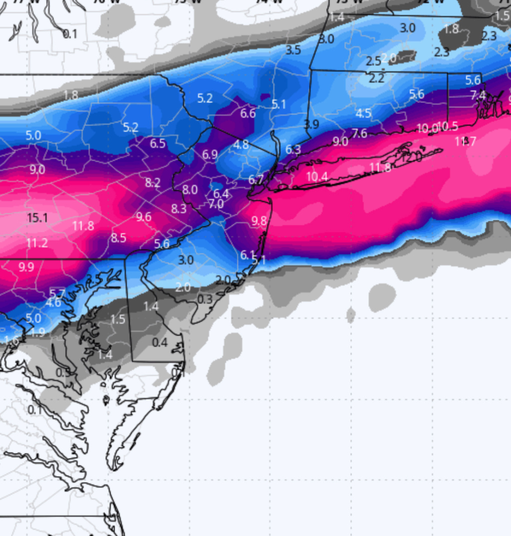
3K NAM is MUCH Colder and has more confluence the N with a Northern Vort that has just swung down.
Snow map is drool worthy for the region

Snow map is drool worthy for the region

_________________
Mugs
AKA:King: Snow Weenie
Self Proclaimed
WINTER 2014-15 : 55.12" +.02 for 6 coatings (avg. 35")
WINTER 2015-16 Total - 29.8" (Avg 35")
WINTER 2016-17 : 39.5" so far

amugs- Advanced Forecaster - Mod

- Posts : 15095
Reputation : 213
Join date : 2013-01-07
Age : 54
Location : Hillsdale,NJ
jmanley32 likes this post
 Re: February 12th-13th 2024 Pre-Valentines Day Storm Potential
tomsriversnowstorm wrote:Can we trust the nam model? Especially with the euro and gfs being different? Is the nam usually correct or incorrect?
I'd say a couple things. One: I don't think there is a dominant model anymore that is more correct than the others. They all seem to have their good moments and bad moments. I've alternatively in any give storm recently heard people say the Euro, GFS, and NAM are rubish. So have to just really be careful about buying into any of them verbatim and can't really throw any model out or bank entirely on any model. Two: The GFS and Euro both trended south/colder on their last runs (12z) so they're not as far out of step with the NAM as you might think. Although clearly this particular NAM run is a big shift so I'd want to see more agreement from other models in the next couple runs before buying in completely.

billg315- Advanced Forecaster - Mod

- Posts : 4483
Reputation : 185
Join date : 2015-01-24
Age : 50
Location : Flemington, NJ
Page 4 of 13 •  1, 2, 3, 4, 5 ... 11, 12, 13
Page 4 of 13
Permissions in this forum:
You cannot reply to topics in this forum|
|
|

 Home
Home