
 Search
Official Long Range Thread 3.0
Page 11 of 32 •  1 ... 7 ... 10, 11, 12 ... 21 ... 32
 ![]()
Re: Official Long Range Thread 3.0
![]() by Frank_Wx Wed Aug 27, 2014 12:10 pm
by Frank_Wx Wed Aug 27, 2014 12:10 pm
Frank_Wx- Godzilla Seeker

- Posts : 21305
Join date : 2013-01-05 -

Re: Official Long Range Thread 3.0
![]() by mako460 Wed Aug 27, 2014 12:54 pm
by mako460 Wed Aug 27, 2014 12:54 pm
mako460- Pro Enthusiast

- Posts : 346
Join date : 2013-01-09
Re: Official Long Range Thread 3.0
![]() by amugs Sun Aug 31, 2014 9:18 am
by amugs Sun Aug 31, 2014 9:18 am
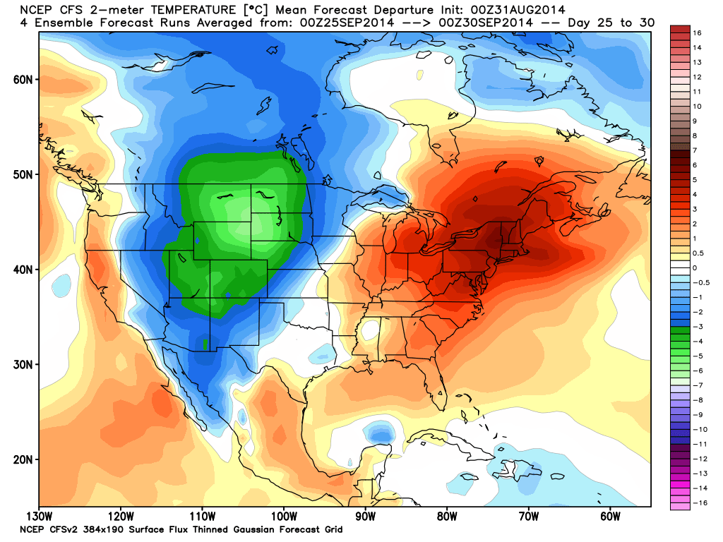
mako460 wrote:Go figure, lol. Fortunately for me i just put a pool in for my kids and this heat only helps to warm up the water.
Looks like you will be getting some use out of that pool next month:
_________________
Mugs
AKA:King: Snow Weenie
Self Proclaimed
WINTER 2014-15 : 55.12" +.02 for 6 coatings (avg. 35")
WINTER 2015-16 Total - 29.8" (Avg 35")
WINTER 2016-17 : 39.5" so far

amugs- Advanced Forecaster - Mod

- Posts : 15093
Reputation : 213
Join date : 2013-01-07
Age : 54
Location : Hillsdale,NJ
Re: Official Long Range Thread 3.0
![]() by algae888 Sun Aug 31, 2014 10:31 am
by algae888 Sun Aug 31, 2014 10:31 am

algae888- Advanced Forecaster

- Posts : 5311
Reputation : 46
Join date : 2013-02-05
Age : 61
Location : mt. vernon, new york
Re: Official Long Range Thread 3.0
![]() by amugs Sun Aug 31, 2014 12:30 pm
by amugs Sun Aug 31, 2014 12:30 pm
algae888 wrote:mugs next week (9th-16) looks to be very cool with highs in the 60's and several chances for rain. as for the end of the month into October, even though that map looks hot, temps probably in upper 70,s to low 80,s.
Al, I see that and things will be interesting as you have so pointed out - is it the lack of data due to the holiday weekend? Could be and if so I think come Tuesday's 12z runs we have a better picture going forward. I hear you on the map I showed not 90's due to climo and longer nights shorter days but 80's and Indian Summer - maybe.
70's/80's would be above normal by about 10*+ for this time of year since the average is 70* if it gets to 80 or higher.
_________________
Mugs
AKA:King: Snow Weenie
Self Proclaimed
WINTER 2014-15 : 55.12" +.02 for 6 coatings (avg. 35")
WINTER 2015-16 Total - 29.8" (Avg 35")
WINTER 2016-17 : 39.5" so far
amugs- Advanced Forecaster - Mod
- Posts : 15093
Reputation : 213
Join date : 2013-01-07
Age : 54
Location : Hillsdale,NJ
Re: Official Long Range Thread 3.0
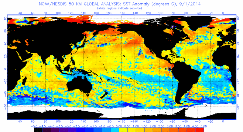
![]() by Isotherm Mon Sep 01, 2014 5:57 pm
by Isotherm Mon Sep 01, 2014 5:57 pm
There's an enormous amount of heat contained in the SST's across the nern hemisphere right now. These will likely cool as we head toward winter as is climo, but I expect the PDO and AMO will remain positive. Definite implications for the winter regime but that's awhile down the road.
For the shorter/medium term, I'm going +2 to +3 for temperature departures in the Northeast DCA-BOS corridor for September. If it's not in that range I'd expect the bust to be warmer not cooler than +2 to +3. The next week or so should rack up positive departures on the order of +5 to +10 when we couple the torrid days with the elevated minima/overnight lows. Second half of September will get cooler - duh - climo begins to plummet, but relative to normal I think the mean ridge stays near the East Coast for most of the next few weeks.
Isotherm- Advanced Forecaster
- Posts : 231
Reputation : 4
Join date : 2014-09-01
Age : 33
Location : Monmouth County, NJ -
Re: Official Long Range Thread 3.0
![]() by Dunnzoo Mon Sep 01, 2014 6:18 pm
by Dunnzoo Mon Sep 01, 2014 6:18 pm
Isotherm wrote:Hey guys - what's up. Some of you might know me from American or Usawx.
There's an enormous amount of heat contained in the SST's across the nern hemisphere right now. These will likely cool as we head toward winter as is climo, but I expect the PDO and AMO will remain positive. Definite implications for the winter regime but that's awhile down the road.
For the shorter/medium term, I'm going +2 to +3 for temperature departures in the Northeast DCA-BOS corridor for September. If it's not in that range I'd expect the bust to be warmer not cooler than +2 to +3. The next week or so should rack up positive departures on the order of +5 to +10 when we couple the torrid days with the elevated minima/overnight lows. Second half of September will get cooler - duh - climo begins to plummet, but relative to normal I think the mean ridge stays near the East Coast for most of the next few weeks.
Welcome! When you get a chance, would you mind adding your location to your profile? It helps when we all start posting obs, especially snow
Nice write-up....things are trending warmer.....
_________________
Janet
Snowfall winter of 2023-2024 17.5"
Snowfall winter of 2022-2023 6.0"
Snowfall winter of 2021-2022 17.6" 1" sleet 2/25/22
Snowfall winter of 2020-2021 51.1"
Snowfall winter of 2019-2020 8.5"
Snowfall winter of 2018-2019 25.1"
Snowfall winter of 2017-2018 51.9"
Snowfall winter of 2016-2017 45.6"
Snowfall winter of 2015-2016 29.5"
Snowfall winter of 2014-2015 50.55"
Snowfall winter of 2013-2014 66.5"

Dunnzoo- Senior Enthusiast - Mod
- Posts : 4892
Reputation : 68
Join date : 2013-01-11
Age : 62
Location : Westwood, NJ
Re: Official Long Range Thread 3.0
![]() by amugs Mon Sep 01, 2014 9:06 pm
by amugs Mon Sep 01, 2014 9:06 pm
Isotherm wrote:Hey guys - what's up. Some of you might know me from American or Usawx.
There's an enormous amount of heat contained in the SST's across the nern hemisphere right now. These will likely cool as we head toward winter as is climo, but I expect the PDO and AMO will remain positive. Definite implications for the winter regime but that's awhile down the road.
For the shorter/medium term, I'm going +2 to +3 for temperature departures in the Northeast DCA-BOS corridor for September. If it's not in that range I'd expect the bust to be warmer not cooler than +2 to +3. The next week or so should rack up positive departures on the order of +5 to +10 when we couple the torrid days with the elevated minima/overnight lows. Second half of September will get cooler - duh - climo begins to plummet, but relative to normal I think the mean ridge stays near the East Coast for most of the next few weeks.
WELCOME ABOARD Tom!!!
I hope you enjoy and share many tremendously informative w rite ups and predictions/analysis on this board as well.
I ver much look forward to your posts.
I believe you will really like the folks on this board, very family oriented and many passionate weather weenie's!!
A wonderfully great group of people on here.
Again, welcome.
Mugs ( aka Self Proclaimed - King Snow Weenie)
_________________
Mugs
AKA:King: Snow Weenie
Self Proclaimed
WINTER 2014-15 : 55.12" +.02 for 6 coatings (avg. 35")
WINTER 2015-16 Total - 29.8" (Avg 35")
WINTER 2016-17 : 39.5" so far
amugs- Advanced Forecaster - Mod
- Posts : 15093
Reputation : 213
Join date : 2013-01-07
Age : 54
Location : Hillsdale,NJ
Re: Official Long Range Thread 3.0
![]() by amugs Mon Sep 01, 2014 9:32 pm
by amugs Mon Sep 01, 2014 9:32 pm

Looks like a hot one tomorrow like low to mid 90's then mid to upper 80's on we'd maybe 90 then we rebound to
the heat for fri and sat then a cold front moves through sat night into sun and we cool down and the above normal temps look to
try and return middle of next week - we shall see.
_________________
Mugs
AKA:King: Snow Weenie
Self Proclaimed
WINTER 2014-15 : 55.12" +.02 for 6 coatings (avg. 35")
WINTER 2015-16 Total - 29.8" (Avg 35")
WINTER 2016-17 : 39.5" so far
amugs- Advanced Forecaster - Mod
- Posts : 15093
Reputation : 213
Join date : 2013-01-07
Age : 54
Location : Hillsdale,NJ
Re: Official Long Range Thread 3.0
![]() by Isotherm Mon Sep 01, 2014 11:14 pm
by Isotherm Mon Sep 01, 2014 11:14 pm
Isotherm- Advanced Forecaster
- Posts : 231
Reputation : 4
Join date : 2014-09-01
Age : 33
Location : Monmouth County, NJ -
Re: Official Long Range Thread 3.0
![]() by Frank_Wx Mon Sep 01, 2014 11:46 pm
by Frank_Wx Mon Sep 01, 2014 11:46 pm
This week continues to look warm with the -PNA in the west leading to ridging in the east. Definitely one of, if not the warmest, week of the summer for some folks.
I do think by the weekend temps return back to normal. That's pretty consistent on guidance right now.
_________________
_______________________________________________________________________________________________________
CLICK HERE to view NJ Strong Snowstorm Classifications

Frank_Wx- Godzilla Seeker
- Posts : 21305
Reputation : 328
Join date : 2013-01-05
Age : 31
Location : Jersey City, NJ -
Re: Official Long Range Thread 3.0
![]() by HectorO Tue Sep 02, 2014 9:16 am
by HectorO Tue Sep 02, 2014 9:16 am
Frank_Wx wrote:Welcome aboard Tom! I think many people on here will appreciate your insight / knowledge / intelligence in regards to the weather, specifically long range.
This week continues to look warm with the -PNA in the west leading to ridging in the east. Definitely one of, if not the warmest, week of the summer for some folks.
I do think by the weekend temps return back to normal. That's pretty consistent on guidance right now.
Yea, looks like late weekend. By starting Sunday and Monday the trend changes a little, still might be some low 80s next week maybe even mid 80s, but not like this week.

HectorO- Pro Enthusiast
- Posts : 959
Reputation : 27
Join date : 2013-01-11
Re: Official Long Range Thread 3.0
![]() by Isotherm Tue Sep 02, 2014 9:55 am
by Isotherm Tue Sep 02, 2014 9:55 am
Frank_Wx wrote:Welcome aboard Tom! I think many people on here will appreciate your insight / knowledge / intelligence in regards to the weather, specifically long range.
This week continues to look warm with the -PNA in the west leading to ridging in the east. Definitely one of, if not the warmest, week of the summer for some folks.
I do think by the weekend temps return back to normal. That's pretty consistent on guidance right now.
Thanks Frank! It seems like you have some great people on this board. I agree about this coming week. As everyone heads back to work/school, now summer actually begins.
Isotherm- Advanced Forecaster
- Posts : 231
Reputation : 4
Join date : 2014-09-01
Age : 33
Location : Monmouth County, NJ -
Re: Official Long Range Thread 3.0
![]() by nutleyblizzard Tue Sep 02, 2014 1:53 pm
by nutleyblizzard Tue Sep 02, 2014 1:53 pm
Good to see you on this weatherboard, Tom. American WX can get a little testy at times with all the bickering going around. With the upcoming winter coming up, you will be a great addition to this site.Isotherm wrote:Hey guys - what's up. Some of you might know me from American or Usawx.
There's an enormous amount of heat contained in the SST's across the nern hemisphere right now. These will likely cool as we head toward winter as is climo, but I expect the PDO and AMO will remain positive. Definite implications for the winter regime but that's awhile down the road.
For the shorter/medium term, I'm going +2 to +3 for temperature departures in the Northeast DCA-BOS corridor for September. If it's not in that range I'd expect the bust to be warmer not cooler than +2 to +3. The next week or so should rack up positive departures on the order of +5 to +10 when we couple the torrid days with the elevated minima/overnight lows. Second half of September will get cooler - duh - climo begins to plummet, but relative to normal I think the mean ridge stays near the East Coast for most of the next few weeks.

nutleyblizzard- Senior Enthusiast

- Posts : 1952
Reputation : 41
Join date : 2014-01-30
Age : 58
Location : Nutley, new jersey
Re: Official Long Range Thread 3.0
![]() by Vinnydula Tue Sep 02, 2014 2:18 pm
by Vinnydula Tue Sep 02, 2014 2:18 pm

Vinnydula- Pro Enthusiast
- Posts : 778
Reputation : 8
Join date : 2013-12-12
Location : Dobbs ferry
Re: Official Long Range Thread 3.0
![]() by Dunnzoo Tue Sep 02, 2014 2:33 pm
by Dunnzoo Tue Sep 02, 2014 2:33 pm
_________________
Janet
Snowfall winter of 2023-2024 17.5"
Snowfall winter of 2022-2023 6.0"
Snowfall winter of 2021-2022 17.6" 1" sleet 2/25/22
Snowfall winter of 2020-2021 51.1"
Snowfall winter of 2019-2020 8.5"
Snowfall winter of 2018-2019 25.1"
Snowfall winter of 2017-2018 51.9"
Snowfall winter of 2016-2017 45.6"
Snowfall winter of 2015-2016 29.5"
Snowfall winter of 2014-2015 50.55"
Snowfall winter of 2013-2014 66.5"
Dunnzoo- Senior Enthusiast - Mod
- Posts : 4892
Reputation : 68
Join date : 2013-01-11
Age : 62
Location : Westwood, NJ
Re: Official Long Range Thread 3.0
![]() by algae888 Tue Sep 02, 2014 7:13 pm
by algae888 Tue Sep 02, 2014 7:13 pm
A CONTINENTAL POLAR
AIRMASS BUILDS IN BEHIND THE FRONT. COLD AIR ADVECTION WILL KEEP
TEMPERATURES AT OR BELOW NORMAL SUNDAY THROUGH TUESDAY...IN THE
70S...WHILE DEWPOINTS WILL BE WELL IN THE 50S.
algae888- Advanced Forecaster
- Posts : 5311
Reputation : 46
Join date : 2013-02-05
Age : 61
Location : mt. vernon, new york
Re: Official Long Range Thread 3.0
![]() by Frank_Wx Tue Sep 02, 2014 7:42 pm
by Frank_Wx Tue Sep 02, 2014 7:42 pm
algae888 wrote:we just have to get through these next 3-4 days and then we have a nice cool down. here is nws disco for early next week.
A CONTINENTAL POLAR
AIRMASS BUILDS IN BEHIND THE FRONT. COLD AIR ADVECTION WILL KEEP
TEMPERATURES AT OR BELOW NORMAL SUNDAY THROUGH TUESDAY...IN THE
70S...WHILE DEWPOINTS WILL BE WELL IN THE 50S.
Not sure I agree with them just yet. It depends how entrenched the trough gets over the northeast. There could be quite a bit of moderation before it gets here. We'll see how things look in a couple of days.
_________________
_______________________________________________________________________________________________________
CLICK HERE to view NJ Strong Snowstorm Classifications
Frank_Wx- Godzilla Seeker
- Posts : 21305
Reputation : 328
Join date : 2013-01-05
Age : 31
Location : Jersey City, NJ -
Re: Official Long Range Thread 3.0
![]() by Frank_Wx Tue Sep 02, 2014 7:43 pm
by Frank_Wx Tue Sep 02, 2014 7:43 pm
_________________
_______________________________________________________________________________________________________
CLICK HERE to view NJ Strong Snowstorm Classifications
Frank_Wx- Godzilla Seeker
- Posts : 21305
Reputation : 328
Join date : 2013-01-05
Age : 31
Location : Jersey City, NJ -
Re: Official Long Range Thread 3.0
![]() by Frank_Wx Tue Sep 02, 2014 7:50 pm
by Frank_Wx Tue Sep 02, 2014 7:50 pm

The Canadian model says that once this warm regime moves out, the -EPO returns and a broad-scale trough invades the Great Lakes and Ohio Valley regions, while the coast remains around average. If the trough gets to the coast (or even if it comes to fruition at all), will depend on the -EPO and +PNA.
_________________
_______________________________________________________________________________________________________
CLICK HERE to view NJ Strong Snowstorm Classifications
Frank_Wx- Godzilla Seeker
- Posts : 21305
Reputation : 328
Join date : 2013-01-05
Age : 31
Location : Jersey City, NJ -
Re: Official Long Range Thread 3.0
![]() by Frank_Wx Tue Sep 02, 2014 7:51 pm
by Frank_Wx Tue Sep 02, 2014 7:51 pm
Vinnydula wrote:Heavy rain for about ten minutes. Tamp went from 94 to 78?
After it rains in a very humid / muggy atmosphere it is not uncommon to see temps take a tumble like that. It may even warm up again depending on the time of day. Nice to see you post, Vinny.
_________________
_______________________________________________________________________________________________________
CLICK HERE to view NJ Strong Snowstorm Classifications
Frank_Wx- Godzilla Seeker
- Posts : 21305
Reputation : 328
Join date : 2013-01-05
Age : 31
Location : Jersey City, NJ -
Re: Official Long Range Thread 3.0
![]() by HectorO Tue Sep 02, 2014 7:52 pm
by HectorO Tue Sep 02, 2014 7:52 pm
HectorO- Pro Enthusiast
- Posts : 959
Reputation : 27
Join date : 2013-01-11
Re: Official Long Range Thread 3.0
![]() by Frank_Wx Tue Sep 02, 2014 7:54 pm
by Frank_Wx Tue Sep 02, 2014 7:54 pm
HectorO wrote:I agree, as I said above. Next week, starting Sunday, temps will be cooler and we'll see 70s but I think we'll still see some mid 80s even high 80s for another few days. Today was hot, but is it weird that I was expecting it to feel worse? Maybe it's just my Caribbean blood.

I thought today sucked.
Maybe it is, haha
_________________
_______________________________________________________________________________________________________
CLICK HERE to view NJ Strong Snowstorm Classifications
Frank_Wx- Godzilla Seeker
- Posts : 21305
Reputation : 328
Join date : 2013-01-05
Age : 31
Location : Jersey City, NJ -
Re: Official Long Range Thread 3.0
![]() by Dunnzoo Tue Sep 02, 2014 7:57 pm
by Dunnzoo Tue Sep 02, 2014 7:57 pm
_________________
Janet
Snowfall winter of 2023-2024 17.5"
Snowfall winter of 2022-2023 6.0"
Snowfall winter of 2021-2022 17.6" 1" sleet 2/25/22
Snowfall winter of 2020-2021 51.1"
Snowfall winter of 2019-2020 8.5"
Snowfall winter of 2018-2019 25.1"
Snowfall winter of 2017-2018 51.9"
Snowfall winter of 2016-2017 45.6"
Snowfall winter of 2015-2016 29.5"
Snowfall winter of 2014-2015 50.55"
Snowfall winter of 2013-2014 66.5"
Dunnzoo- Senior Enthusiast - Mod
- Posts : 4892
Reputation : 68
Join date : 2013-01-11
Age : 62
Location : Westwood, NJ
Re: Official Long Range Thread 3.0
![]() by Frank_Wx Tue Sep 02, 2014 8:03 pm
by Frank_Wx Tue Sep 02, 2014 8:03 pm
Dunnzoo wrote:This morning was worse....after the downpour we had, it didn't seem as oppressive, much more tolerable.... I have to laugh at the media, saying 85*- 88* is hot....I don't consider it hot until it is at least 90*, we have been so spoiled with the temps this summer, hi 80's is not hot!
Some areas did see low 90's today. I think Newark hit it.
_________________
_______________________________________________________________________________________________________
CLICK HERE to view NJ Strong Snowstorm Classifications
Frank_Wx- Godzilla Seeker
- Posts : 21305
Reputation : 328
Join date : 2013-01-05
Age : 31
Location : Jersey City, NJ -
Re: Official Long Range Thread 3.0
![]() by jmanley32 Tue Sep 02, 2014 8:12 pm
by jmanley32 Tue Sep 02, 2014 8:12 pm

jmanley32- Senior Enthusiast
- Posts : 20517
Reputation : 108
Join date : 2013-12-12
Age : 42
Location : Yonkers, NY
Re: Official Long Range Thread 3.0
![]() by amugs Tue Sep 02, 2014 9:02 pm
by amugs Tue Sep 02, 2014 9:02 pm
We hit it 91.4* in Hillsdale todayFrank_Wx wrote:Dunnzoo wrote:This morning was worse....after the downpour we had, it didn't seem as oppressive, much more tolerable.... I have to laugh at the media, saying 85*- 88* is hot....I don't consider it hot until it is at least 90*, we have been so spoiled with the temps this summer, hi 80's is not hot!
Some areas did see low 90's today. I think Newark hit it.
Janet temps wise no but with the dew pt and humidity in the 70's it was gross out today.
_________________
Mugs
AKA:King: Snow Weenie
Self Proclaimed
WINTER 2014-15 : 55.12" +.02 for 6 coatings (avg. 35")
WINTER 2015-16 Total - 29.8" (Avg 35")
WINTER 2016-17 : 39.5" so far
amugs- Advanced Forecaster - Mod
- Posts : 15093
Reputation : 213
Join date : 2013-01-07
Age : 54
Location : Hillsdale,NJ
Page 11 of 32 • 1 ... 7 ... 10, 11, 12 ... 21 ... 32 ![]()
|
|
|