
 Search
Official Long Range Thread 3.0
Page 24 of 32 •  1 ... 13 ... 23, 24, 25 ... 28 ... 32
 ![]()
Re: Official Long Range Thread 3.0
![]() by Math23x7 Thu Oct 16, 2014 3:53 pm
by Math23x7 Thu Oct 16, 2014 3:53 pm
Math23x7- Wx Statistician Guru

- Posts : 2379
Join date : 2013-01-08
Re: Official Long Range Thread 3.0
![]() by sroc4 Thu Oct 16, 2014 3:53 pm
by sroc4 Thu Oct 16, 2014 3:53 pm
jmanley32 wrote:OMG sroc you make me laugh so hard I made myself chock LOLOLOLOL my coworkers came running because I have never laughed like that at work before. Yes I agree, that was awesome! One of my fav movies too. CMC is known for its crazy runs but its not as far off in time as some crazy runs usually are, as frank said its a def threat but a weak low at this time. IMO itsd always best to be prepared for the worst and home for the best but I guess Frank likes to start easy and then if worse comes he will point it out. Still laughing inside.
LOL I have to be honest I laughed at myself while I was fining that you tube video.
sroc4- Admin

- Posts : 8331
Join date : 2013-01-07
Re: Official Long Range Thread 3.0
![]() by Quietace Thu Oct 16, 2014 3:56 pm
by Quietace Thu Oct 16, 2014 3:56 pm
Agree, Not exactly what we are looking for a strong EC low...though if its given time to organize over the Atlantic, by a slower ULL in the Pacific things could develop. Well just wait and see how the pattern materializes over the next day or so.Frank_Wx wrote:Yea, im looking into next week right now. Time frame looks to be Tuesday into Wednesday. My problem with this storm is that the ridge axis is over the Midwest. Usually we like to see it in the western US. Theres also a kicker entering the Pacific NW which might speed the flow up to much for any organized storm to form. Right now im thinking theres a real threat, but some things have to change in order for it to be an impactful storm. Not sure it happens. Im thinking weak coastal for now.


Quietace- Meteorologist - Mod

- Posts : 3687
Reputation : 33
Join date : 2013-01-07
Age : 27
Location : Point Pleasant, NJ
Re: Official Long Range Thread 3.0
![]() by jmanley32 Thu Oct 16, 2014 4:03 pm
by jmanley32 Thu Oct 16, 2014 4:03 pm
Last edited by jmanley32 on Thu Oct 16, 2014 4:27 pm; edited 1 time in total

jmanley32- Senior Enthusiast

- Posts : 20513
Reputation : 108
Join date : 2013-12-12
Age : 42
Location : Yonkers, NY
Quietace- Meteorologist - Mod
- Posts : 3687
Reputation : 33
Join date : 2013-01-07
Age : 27
Location : Point Pleasant, NJ
Re: Official Long Range Thread 3.0
![]() by jmanley32 Thu Oct 16, 2014 4:51 pm
by jmanley32 Thu Oct 16, 2014 4:51 pm
jmanley32- Senior Enthusiast
- Posts : 20513
Reputation : 108
Join date : 2013-12-12
Age : 42
Location : Yonkers, NY
Re: Official Long Range Thread 3.0
![]() by amugs Thu Oct 16, 2014 5:50 pm
by amugs Thu Oct 16, 2014 5:50 pm


_________________
Mugs
AKA:King: Snow Weenie
Self Proclaimed
WINTER 2014-15 : 55.12" +.02 for 6 coatings (avg. 35")
WINTER 2015-16 Total - 29.8" (Avg 35")
WINTER 2016-17 : 39.5" so far

amugs- Advanced Forecaster - Mod

- Posts : 15093
Reputation : 213
Join date : 2013-01-07
Age : 54
Location : Hillsdale,NJ
Re: Official Long Range Thread 3.0
![]() by amugs Thu Oct 16, 2014 5:51 pm
by amugs Thu Oct 16, 2014 5:51 pm

_________________
Mugs
AKA:King: Snow Weenie
Self Proclaimed
WINTER 2014-15 : 55.12" +.02 for 6 coatings (avg. 35")
WINTER 2015-16 Total - 29.8" (Avg 35")
WINTER 2016-17 : 39.5" so far
amugs- Advanced Forecaster - Mod
- Posts : 15093
Reputation : 213
Join date : 2013-01-07
Age : 54
Location : Hillsdale,NJ
Re: Official Long Range Thread 3.0
![]() by jmanley32 Thu Oct 16, 2014 7:10 pm
by jmanley32 Thu Oct 16, 2014 7:10 pm
Last edited by jmanley32 on Thu Oct 16, 2014 7:23 pm; edited 1 time in total
jmanley32- Senior Enthusiast
- Posts : 20513
Reputation : 108
Join date : 2013-12-12
Age : 42
Location : Yonkers, NY
Re: Official Long Range Thread 3.0
![]() by jmanley32 Thu Oct 16, 2014 7:16 pm
by jmanley32 Thu Oct 16, 2014 7:16 pm
jmanley32- Senior Enthusiast
- Posts : 20513
Reputation : 108
Join date : 2013-12-12
Age : 42
Location : Yonkers, NY
Re: Official Long Range Thread 3.0
![]() by sroc4 Thu Oct 16, 2014 7:37 pm
by sroc4 Thu Oct 16, 2014 7:37 pm
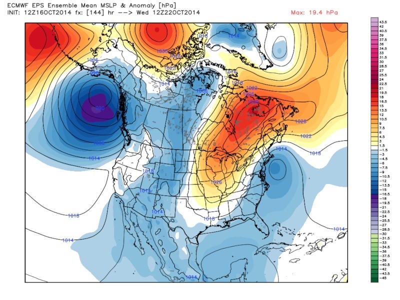
jmanley32 wrote:Dayummm, many of the Euro ensembles (50 stamp) show this system stalling or looping for damn near 3 days! Starts around day 5 and some of then don't get it completely out of the area until day 8 or so, thats crazy. That would be nuts. What would be dring this system to do that, I am sorry to keep asking but thats over my head on how that would happen or is it just doing its thing on the models?
Jman the reason we are seeing this on the surface is because another huge upper level low cuts off from the main flow. I am at work right now other wise Id post the image. But its in the 500mb charts that answers your question. Ill be home in about 45 mins and I will post an image. Go to the Euro and look at hr 168. A HUGE ULL that is completely cutoff from the main flow. The cuttoff ULL meanders until as series of short wave energy digs in from northern canada to open up the ULL and move things along.
_________________
"In weather and in life, there's no winning and losing; there's only winning and learning."
WINTER 2012/2013 TOTALS 43.65"WINTER 2017/2018 TOTALS 62.85" WINTER 2022/2023 TOTALS 4.9"
WINTER 2013/2014 TOTALS 64.85"WINTER 2018/2019 TOTALS 14.25" WINTER 2023/2024 TOTALS 13.1"
WINTER 2014/2015 TOTALS 71.20"WINTER 2019/2020 TOTALS 6.35"
WINTER 2015/2016 TOTALS 35.00"WINTER 2020/2021 TOTALS 37.75"
WINTER 2016/2017 TOTALS 42.25"WINTER 2021/2022 TOTALS 31.65"

sroc4- Admin
- Posts : 8331
Reputation : 301
Join date : 2013-01-07
Location : Wading River, LI
Re: Official Long Range Thread 3.0
![]() by sroc4 Thu Oct 16, 2014 7:38 pm
by sroc4 Thu Oct 16, 2014 7:38 pm
[img]
 [/img]
_________________
"In weather and in life, there's no winning and losing; there's only winning and learning."
WINTER 2012/2013 TOTALS 43.65"WINTER 2017/2018 TOTALS 62.85" WINTER 2022/2023 TOTALS 4.9"
WINTER 2013/2014 TOTALS 64.85"WINTER 2018/2019 TOTALS 14.25" WINTER 2023/2024 TOTALS 13.1"
WINTER 2014/2015 TOTALS 71.20"WINTER 2019/2020 TOTALS 6.35"
WINTER 2015/2016 TOTALS 35.00"WINTER 2020/2021 TOTALS 37.75"
WINTER 2016/2017 TOTALS 42.25"WINTER 2021/2022 TOTALS 31.65"
sroc4- Admin
- Posts : 8331
Reputation : 301
Join date : 2013-01-07
Location : Wading River, LI
Re: Official Long Range Thread 3.0
![]() by jmanley32 Thu Oct 16, 2014 7:43 pm
by jmanley32 Thu Oct 16, 2014 7:43 pm
jmanley32- Senior Enthusiast
- Posts : 20513
Reputation : 108
Join date : 2013-12-12
Age : 42
Location : Yonkers, NY
Re: Official Long Range Thread 3.0
![]() by jmanley32 Thu Oct 16, 2014 7:49 pm
by jmanley32 Thu Oct 16, 2014 7:49 pm
Update: I found the 500 maps, wow that ULL sticks around a LONG time, if this were to play out could be quite a situation, IMO.
jmanley32- Senior Enthusiast
- Posts : 20513
Reputation : 108
Join date : 2013-12-12
Age : 42
Location : Yonkers, NY
Re: Official Long Range Thread 3.0
![]() by sroc4 Thu Oct 16, 2014 7:55 pm
by sroc4 Thu Oct 16, 2014 7:55 pm
jmanley32 wrote:Its tiny but you can open it up, so let me see if I get this right, thats sitting over the area and the other low is meandering around being pushed by that ULL thats stuck there? Are the 500mb maps are above or below the other maps that show the system looping, I assume thats the surface and this one you show is higher up and pushing that one around? Is this a possibility, would be first time I remember seeing something like that, would be a very prolonged period of high winds as the passes are made and CMC shows a ton of wet (9-12 inches for southern MA (OMG if that was snow, yes I know it won't but if it was winter I think you would hear all of us all over the tri-state, especially in 3-4 days if it showed the same thing, lol)! I highly doubt that amount of rain but multiple passes of a low could do a lot of rain), although the Euro does not show the rain but shows a lot of wind.
The energy embedded in the spin of an ULL is what generates the surface low pressure. So when the ULL moves the center of the surface LP moves accordingly. Open this link. Save this link to your favorites. It has a ton of great info.
http://www.theweatherprediction.com/habyhints/2/
_________________
"In weather and in life, there's no winning and losing; there's only winning and learning."
WINTER 2012/2013 TOTALS 43.65"WINTER 2017/2018 TOTALS 62.85" WINTER 2022/2023 TOTALS 4.9"
WINTER 2013/2014 TOTALS 64.85"WINTER 2018/2019 TOTALS 14.25" WINTER 2023/2024 TOTALS 13.1"
WINTER 2014/2015 TOTALS 71.20"WINTER 2019/2020 TOTALS 6.35"
WINTER 2015/2016 TOTALS 35.00"WINTER 2020/2021 TOTALS 37.75"
WINTER 2016/2017 TOTALS 42.25"WINTER 2021/2022 TOTALS 31.65"
sroc4- Admin
- Posts : 8331
Reputation : 301
Join date : 2013-01-07
Location : Wading River, LI
Re: Official Long Range Thread 3.0
![]() by jmanley32 Thu Oct 16, 2014 7:57 pm
by jmanley32 Thu Oct 16, 2014 7:57 pm
jmanley32- Senior Enthusiast
- Posts : 20513
Reputation : 108
Join date : 2013-12-12
Age : 42
Location : Yonkers, NY
Re: Official Long Range Thread 3.0
![]() by jmanley32 Thu Oct 16, 2014 7:58 pm
by jmanley32 Thu Oct 16, 2014 7:58 pm
jmanley32- Senior Enthusiast
- Posts : 20513
Reputation : 108
Join date : 2013-12-12
Age : 42
Location : Yonkers, NY
Re: Official Long Range Thread 3.0
![]() by sroc4 Thu Oct 16, 2014 8:22 pm
by sroc4 Thu Oct 16, 2014 8:22 pm
_________________
"In weather and in life, there's no winning and losing; there's only winning and learning."
WINTER 2012/2013 TOTALS 43.65"WINTER 2017/2018 TOTALS 62.85" WINTER 2022/2023 TOTALS 4.9"
WINTER 2013/2014 TOTALS 64.85"WINTER 2018/2019 TOTALS 14.25" WINTER 2023/2024 TOTALS 13.1"
WINTER 2014/2015 TOTALS 71.20"WINTER 2019/2020 TOTALS 6.35"
WINTER 2015/2016 TOTALS 35.00"WINTER 2020/2021 TOTALS 37.75"
WINTER 2016/2017 TOTALS 42.25"WINTER 2021/2022 TOTALS 31.65"
sroc4- Admin
- Posts : 8331
Reputation : 301
Join date : 2013-01-07
Location : Wading River, LI
Re: Official Long Range Thread 3.0
![]() by jmanley32 Thu Oct 16, 2014 9:04 pm
by jmanley32 Thu Oct 16, 2014 9:04 pm
jmanley32- Senior Enthusiast
- Posts : 20513
Reputation : 108
Join date : 2013-12-12
Age : 42
Location : Yonkers, NY
Re: Official Long Range Thread 3.0
![]() by Frank_Wx Thu Oct 16, 2014 9:09 pm
by Frank_Wx Thu Oct 16, 2014 9:09 pm
Euro ensemble members have this storm all over the place with varying degrees of intensity. I may do a blog on this. Would be my first blog since August.., wow
_________________
_______________________________________________________________________________________________________
CLICK HERE to view NJ Strong Snowstorm Classifications

Frank_Wx- Godzilla Seeker
- Posts : 21305
Reputation : 328
Join date : 2013-01-05
Age : 31
Location : Jersey City, NJ -

Re: Official Long Range Thread 3.0
![]() by jmanley32 Thu Oct 16, 2014 9:31 pm
by jmanley32 Thu Oct 16, 2014 9:31 pm
jmanley32- Senior Enthusiast
- Posts : 20513
Reputation : 108
Join date : 2013-12-12
Age : 42
Location : Yonkers, NY
Re: Official Long Range Thread 3.0
![]() by Frank_Wx Thu Oct 16, 2014 9:44 pm
by Frank_Wx Thu Oct 16, 2014 9:44 pm
jmanley32 wrote:Yeah that was posted a page or so back, seems to be a bit of a train of then from Jersey shore up to LI, thats the only place I really see any consolidation, otherwise like you said ALLLL over the place. But generally in the area. A blog would be cool, will wait to see if you do so, I would imagine in a few days though when it gets closer right?
Maybe tomorrow night or Saturday morning
_________________
_______________________________________________________________________________________________________
CLICK HERE to view NJ Strong Snowstorm Classifications
Frank_Wx- Godzilla Seeker
- Posts : 21305
Reputation : 328
Join date : 2013-01-05
Age : 31
Location : Jersey City, NJ -
Re: Official Long Range Thread 3.0
![]() by amugs Fri Oct 17, 2014 8:39 am
by amugs Fri Oct 17, 2014 8:39 am
Details to work out and we'll see what it does but for the love of god things are starting to pick up and make this boring dry pattern come to an end I hope for the next 5 months at least we have this.

_________________
Mugs
AKA:King: Snow Weenie
Self Proclaimed
WINTER 2014-15 : 55.12" +.02 for 6 coatings (avg. 35")
WINTER 2015-16 Total - 29.8" (Avg 35")
WINTER 2016-17 : 39.5" so far
amugs- Advanced Forecaster - Mod
- Posts : 15093
Reputation : 213
Join date : 2013-01-07
Age : 54
Location : Hillsdale,NJ
Re: Official Long Range Thread 3.0
![]() by jmanley32 Fri Oct 17, 2014 9:43 am
by jmanley32 Fri Oct 17, 2014 9:43 am
jmanley32- Senior Enthusiast
- Posts : 20513
Reputation : 108
Join date : 2013-12-12
Age : 42
Location : Yonkers, NY
Re: Official Long Range Thread 3.0
![]() by amugs Fri Oct 17, 2014 10:50 am
by amugs Fri Oct 17, 2014 10:50 am
Just pooped one up on the GFS as usual but that is not the concern for at least I think now - this is interesting but we'll have to see what the 500mb show if they support this - interesting.

_________________
Mugs
AKA:King: Snow Weenie
Self Proclaimed
WINTER 2014-15 : 55.12" +.02 for 6 coatings (avg. 35")
WINTER 2015-16 Total - 29.8" (Avg 35")
WINTER 2016-17 : 39.5" so far
amugs- Advanced Forecaster - Mod
- Posts : 15093
Reputation : 213
Join date : 2013-01-07
Age : 54
Location : Hillsdale,NJ
Re: Official Long Range Thread 3.0
![]() by jmanley32 Fri Oct 17, 2014 12:34 pm
by jmanley32 Fri Oct 17, 2014 12:34 pm
jmanley32- Senior Enthusiast
- Posts : 20513
Reputation : 108
Join date : 2013-12-12
Age : 42
Location : Yonkers, NY
Re: Official Long Range Thread 3.0
![]() by Frank_Wx Fri Oct 17, 2014 12:36 pm
by Frank_Wx Fri Oct 17, 2014 12:36 pm
The EURO Weeklies suggest the end of this month into the 1st half of November is going to feature above normal temps. When I create a winter outlook, I look back at what the Meteorological Fall upper level pattern featured and see if any of those characteristics could carry over into the winter. So far, I am not impressed. Though there are some positives, which include NH Snow Cover and Pacific SST's, that outweigh the Oct/Nov H5 anomalies. So all of this is taken into consideration. It is not so early anymore. November will be here before we know it.
Here are the EURO Weeklies, which by the way, I am not taking seriously until other guidances' hop on board.
Week of Oct. 27th:

Week of Nov. 2nd:

Week of Nov. 9th:

_________________
_______________________________________________________________________________________________________
CLICK HERE to view NJ Strong Snowstorm Classifications
Frank_Wx- Godzilla Seeker
- Posts : 21305
Reputation : 328
Join date : 2013-01-05
Age : 31
Location : Jersey City, NJ -
Page 24 of 32 • 1 ... 13 ... 23, 24, 25 ... 28 ... 32 ![]()
|
|
|