
 Search
Possible Nor'easter Dec. 9th-10th
Page 4 of 20 •  1, 2, 3, 4, 5 ... 12 ... 20
 ![]()
Re: Possible Nor'easter Dec. 9th-10th
![]() by NjWeatherGuy Fri Dec 05, 2014 12:39 pm
by NjWeatherGuy Fri Dec 05, 2014 12:39 pm
Lol, it just cant compute these types of situations, was showing Sandy OTS for a while until it finally realized it was wrong but it did that whole storm wrong as it was happening...sroc4 wrote:amugs wrote:Snow88 wrote:GFS is always the last model to come on board
Goo Fu S - SUCKS - when are we going to realize this with these complex phased type storms - I am sorry but even last winter I had these sentiments and the Euro kicked its but when are we getting the update on this going? 2015? Is the para replacing this - i forget but I read it is being delayed - what else is new.
I saw someone post this on FB describing the GFS. Pretty funny:
Gfs is like a crack head living in the projects trying to stay clean. Living in a halfway house by day, tempted for the rock by night. Trying to do right, gets wrapped back up into it's b.s, and sh-ts the bed. You never know what's going through its mind.....
NjWeatherGuy- Advanced Forecaster

- Posts : 4100
Join date : 2013-01-06
Re: Possible Nor'easter Dec. 9th-10th
![]() by rb924119 Fri Dec 05, 2014 12:44 pm
by rb924119 Fri Dec 05, 2014 12:44 pm
rb924119- Meteorologist

- Posts : 6889
Join date : 2013-02-06
Re: Possible Nor'easter Dec. 9th-10th
![]() by rb924119 Fri Dec 05, 2014 12:50 pm
by rb924119 Fri Dec 05, 2014 12:50 pm
rb924119- Meteorologist
- Posts : 6889
Reputation : 194
Join date : 2013-02-06
Age : 32
Location : Greentown, Pa
Re: Possible Nor'easter Dec. 9th-10th
![]() by SoulSingMG Fri Dec 05, 2014 1:07 pm
by SoulSingMG Fri Dec 05, 2014 1:07 pm

SoulSingMG- Senior Enthusiast

- Posts : 2853
Reputation : 74
Join date : 2013-12-11
Location : Long Island City, NY
Re: Possible Nor'easter Dec. 9th-10th
![]() by algae888 Fri Dec 05, 2014 1:31 pm
by algae888 Fri Dec 05, 2014 1:31 pm


algae888- Advanced Forecaster
- Posts : 5311
Reputation : 46
Join date : 2013-02-05
Age : 61
Location : mt. vernon, new york
Re: Possible Nor'easter Dec. 9th-10th
![]() by rb924119 Fri Dec 05, 2014 1:48 pm
by rb924119 Fri Dec 05, 2014 1:48 pm
rb924119- Meteorologist
- Posts : 6889
Reputation : 194
Join date : 2013-02-06
Age : 32
Location : Greentown, Pa
Re: Possible Nor'easter Dec. 9th-10th
![]() by algae888 Fri Dec 05, 2014 1:53 pm
by algae888 Fri Dec 05, 2014 1:53 pm
rb it is slower than other models. is this what you were saying in previous post that you wanted to see happen.rb924119 wrote:12z EURO OP=GORGEOUSSSSSSSSSSS RUN.......How I wish this was Monday morning ahahaha I will say, though, notice the lack of the binary mid-level lows. In my opinion, this is much more reasonable than the previous run; not that it will happen this way, but it certainly is more feasible.
algae888- Advanced Forecaster
- Posts : 5311
Reputation : 46
Join date : 2013-02-05
Age : 61
Location : mt. vernon, new york
Re: Possible Nor'easter Dec. 9th-10th
![]() by rb924119 Fri Dec 05, 2014 2:02 pm
by rb924119 Fri Dec 05, 2014 2:02 pm
Last edited by rb924119 on Fri Dec 05, 2014 2:12 pm; edited 2 times in total
rb924119- Meteorologist
- Posts : 6889
Reputation : 194
Join date : 2013-02-06
Age : 32
Location : Greentown, Pa
Re: Possible Nor'easter Dec. 9th-10th
![]() by SoulSingMG Fri Dec 05, 2014 2:07 pm
by SoulSingMG Fri Dec 05, 2014 2:07 pm
SoulSingMG- Senior Enthusiast
- Posts : 2853
Reputation : 74
Join date : 2013-12-11
Location : Long Island City, NY
Re: Possible Nor'easter Dec. 9th-10th
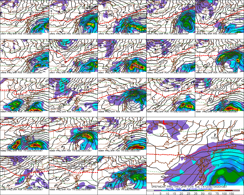
![]() by Frank_Wx Fri Dec 05, 2014 2:38 pm
by Frank_Wx Fri Dec 05, 2014 2:38 pm


Stalls over the area.
_________________
_______________________________________________________________________________________________________
CLICK HERE to view NJ Strong Snowstorm Classifications

Frank_Wx- Godzilla Seeker

- Posts : 21305
Reputation : 328
Join date : 2013-01-05
Age : 31
Location : Jersey City, NJ -

Re: Possible Nor'easter Dec. 9th-10th
![]() by jmanley32 Fri Dec 05, 2014 3:12 pm
by jmanley32 Fri Dec 05, 2014 3:12 pm

jmanley32- Senior Enthusiast
- Posts : 20513
Reputation : 108
Join date : 2013-12-12
Age : 42
Location : Yonkers, NY
Re: Possible Nor'easter Dec. 9th-10th
![]() by jmanley32 Fri Dec 05, 2014 3:42 pm
by jmanley32 Fri Dec 05, 2014 3:42 pm

jmanley32- Senior Enthusiast
- Posts : 20513
Reputation : 108
Join date : 2013-12-12
Age : 42
Location : Yonkers, NY
Re: Possible Nor'easter Dec. 9th-10th
![]() by NjWeatherGuy Fri Dec 05, 2014 3:52 pm
by NjWeatherGuy Fri Dec 05, 2014 3:52 pm

NjWeatherGuy- Advanced Forecaster
- Posts : 4100
Reputation : 28
Join date : 2013-01-06
Location : Belle Mead, NJ
Re: Possible Nor'easter Dec. 9th-10th
![]() by jmanley32 Fri Dec 05, 2014 4:06 pm
by jmanley32 Fri Dec 05, 2014 4:06 pm
jmanley32- Senior Enthusiast
- Posts : 20513
Reputation : 108
Join date : 2013-12-12
Age : 42
Location : Yonkers, NY
Re: Possible Nor'easter Dec. 9th-10th
![]() by amugs Fri Dec 05, 2014 4:51 pm
by amugs Fri Dec 05, 2014 4:51 pm
IN TERMS OF SENSIBLE WX...AN INITIAL SHOT OF WAA PRECIP MON
NIGHT-TUE MORNING...WITH WARMING TEMPS ALOFT BUT REMAINING COLD AT
THE SFC AS THE ARCTIC HIGH DEPARTS...COULD YIELD A PD OF SNOW
CHANGING TO MIXED PRECIP INLAND...WITH MAINLY RAIN AT THE COAST.
THEN AS THE COASTAL LOW WINDS UP...THINK PRECIP LATE TUE MORNING
INTO TUE AFTERNOON SHOULD BE ALL RAIN...WHICH COULD BE HEAVY AT
TIMES GIVEN STRENGTHENING ATLANTIC INFLOW AND COUPLED JET ENERGY.
AS THE LOW REACHES PEAK INTENSITY...WOULD EXPECT DYNAMIC COOLING
WITH DEVELOPING COMMA HEAD PRECIP TO THE NORTH/WEST OF THE SFC LOW
TO QUICKLY CHANGE PRECIP BACK TO ACCUMULATING SNOW NORTH/WEST OF NYC
TUE EVENING AND CONTINUE INTO WED MORNING...WITH SOME POTENTIAL FOR
SIGNIFICANT SNOWFALL. FARTHER SOUTH/EAST...A MORE GRADUAL CHANGE TO
MIXED PRECIP AND THEN LIGHT SNOW FOR NYC METRO...COASTAL SECTIONS
AND SE CT FOR LATE TUE NIGHT INTO WED MORNING APPEARS MORE LIKELY.
EXACT SFC LOW TRACK AND INTENSITY ARE UNCERTAIN... BUT THERE IS ALSO
POTENTIAL FOR A PD OF STRONG E-NE WINDS SOME TIME TUE NIGHT THAT
COULD IMPACT COASTAL SECTIONS IF THE LOW TRACKS JUST TO THE SOUTH.
_________________
Mugs
AKA:King: Snow Weenie
Self Proclaimed
WINTER 2014-15 : 55.12" +.02 for 6 coatings (avg. 35")
WINTER 2015-16 Total - 29.8" (Avg 35")
WINTER 2016-17 : 39.5" so far

amugs- Advanced Forecaster - Mod

- Posts : 15093
Reputation : 213
Join date : 2013-01-07
Age : 54
Location : Hillsdale,NJ
Re: Possible Nor'easter Dec. 9th-10th
![]() by amugs Fri Dec 05, 2014 4:52 pm
by amugs Fri Dec 05, 2014 4:52 pm
amugs wrote:Upton going with the cranking CCB idea with everyone changing to snow with significant accumulations, especially north and west
HOLY SMOKES BY UPTON AT THIS POINT IN TIME -

IN TERMS OF SENSIBLE WX...AN INITIAL SHOT OF WAA PRECIP MON
NIGHT-TUE MORNING...WITH WARMING TEMPS ALOFT BUT REMAINING COLD AT
THE SFC AS THE ARCTIC HIGH DEPARTS...COULD YIELD A PD OF SNOW
CHANGING TO MIXED PRECIP INLAND...WITH MAINLY RAIN AT THE COAST.
THEN AS THE COASTAL LOW WINDS UP...THINK PRECIP LATE TUE MORNING
INTO TUE AFTERNOON SHOULD BE ALL RAIN...WHICH COULD BE HEAVY AT
TIMES GIVEN STRENGTHENING ATLANTIC INFLOW AND COUPLED JET ENERGY.
AS THE LOW REACHES PEAK INTENSITY...WOULD EXPECT DYNAMIC COOLING
WITH DEVELOPING COMMA HEAD PRECIP TO THE NORTH/WEST OF THE SFC LOW
TO QUICKLY CHANGE PRECIP BACK TO ACCUMULATING SNOW NORTH/WEST OF NYC
TUE EVENING AND CONTINUE INTO WED MORNING...WITH SOME POTENTIAL FOR
SIGNIFICANT SNOWFALL. FARTHER SOUTH/EAST...A MORE GRADUAL CHANGE TO
MIXED PRECIP AND THEN LIGHT SNOW FOR NYC METRO...COASTAL SECTIONS
AND SE CT FOR LATE TUE NIGHT INTO WED MORNING APPEARS MORE LIKELY.
EXACT SFC LOW TRACK AND INTENSITY ARE UNCERTAIN... BUT THERE IS ALSO
POTENTIAL FOR A PD OF STRONG E-NE WINDS SOME TIME TUE NIGHT THAT
COULD IMPACT COASTAL SECTIONS IF THE LOW TRACKS JUST TO THE SOUTH.
_________________
Mugs
AKA:King: Snow Weenie
Self Proclaimed
WINTER 2014-15 : 55.12" +.02 for 6 coatings (avg. 35")
WINTER 2015-16 Total - 29.8" (Avg 35")
WINTER 2016-17 : 39.5" so far
amugs- Advanced Forecaster - Mod
- Posts : 15093
Reputation : 213
Join date : 2013-01-07
Age : 54
Location : Hillsdale,NJ
Re: Possible Nor'easter Dec. 9th-10th
![]() by jmanley32 Fri Dec 05, 2014 4:54 pm
by jmanley32 Fri Dec 05, 2014 4:54 pm
jmanley32- Senior Enthusiast
- Posts : 20513
Reputation : 108
Join date : 2013-12-12
Age : 42
Location : Yonkers, NY
Re: Possible Nor'easter Dec. 9th-10th
![]() by jmanley32 Fri Dec 05, 2014 5:02 pm
by jmanley32 Fri Dec 05, 2014 5:02 pm
jmanley32- Senior Enthusiast
- Posts : 20513
Reputation : 108
Join date : 2013-12-12
Age : 42
Location : Yonkers, NY
Re: Possible Nor'easter Dec. 9th-10th
![]() by SoulSingMG Fri Dec 05, 2014 5:32 pm
by SoulSingMG Fri Dec 05, 2014 5:32 pm
amugs wrote:amugs wrote:Upton going with the cranking CCB idea with everyone changing to snow with significant accumulations, especially north and west
HOLY SMOKES BY UPTON AT THIS POINT IN TIME -
IN TERMS OF SENSIBLE WX...AN INITIAL SHOT OF WAA PRECIP MON
NIGHT-TUE MORNING...WITH WARMING TEMPS ALOFT BUT REMAINING COLD AT
THE SFC AS THE ARCTIC HIGH DEPARTS...COULD YIELD A PD OF SNOW
CHANGING TO MIXED PRECIP INLAND...WITH MAINLY RAIN AT THE COAST.
THEN AS THE COASTAL LOW WINDS UP...THINK PRECIP LATE TUE MORNING
INTO TUE AFTERNOON SHOULD BE ALL RAIN...WHICH COULD BE HEAVY AT
TIMES GIVEN STRENGTHENING ATLANTIC INFLOW AND COUPLED JET ENERGY.
AS THE LOW REACHES PEAK INTENSITY...WOULD EXPECT DYNAMIC COOLING
WITH DEVELOPING COMMA HEAD PRECIP TO THE NORTH/WEST OF THE SFC LOW
TO QUICKLY CHANGE PRECIP BACK TO ACCUMULATING SNOW NORTH/WEST OF NYC
TUE EVENING AND CONTINUE INTO WED MORNING...WITH SOME POTENTIAL FOR
SIGNIFICANT SNOWFALL. FARTHER SOUTH/EAST...A MORE GRADUAL CHANGE TO
MIXED PRECIP AND THEN LIGHT SNOW FOR NYC METRO...COASTAL SECTIONS
AND SE CT FOR LATE TUE NIGHT INTO WED MORNING APPEARS MORE LIKELY.
EXACT SFC LOW TRACK AND INTENSITY ARE UNCERTAIN... BUT THERE IS ALSO
POTENTIAL FOR A PD OF STRONG E-NE WINDS SOME TIME TUE NIGHT THAT
COULD IMPACT COASTAL SECTIONS IF THE LOW TRACKS JUST TO THE SOUTH.
Wellllll, not really lol. They are saying mix in NYC for changeover with 'light snow'. This will be a far north and and west biggie IMO.
SoulSingMG- Senior Enthusiast
- Posts : 2853
Reputation : 74
Join date : 2013-12-11
Location : Long Island City, NY
Re: Possible Nor'easter Dec. 9th-10th
![]() by NjWeatherGuy Fri Dec 05, 2014 5:36 pm
by NjWeatherGuy Fri Dec 05, 2014 5:36 pm
NjWeatherGuy- Advanced Forecaster
- Posts : 4100
Reputation : 28
Join date : 2013-01-06
Location : Belle Mead, NJ
Re: Possible Nor'easter Dec. 9th-10th
![]() by amugs Fri Dec 05, 2014 5:37 pm
by amugs Fri Dec 05, 2014 5:37 pm
You folk in these areas will get a deluge unless something changes with the HP, strength of lp or more importantly track of the slp.
_________________
Mugs
AKA:King: Snow Weenie
Self Proclaimed
WINTER 2014-15 : 55.12" +.02 for 6 coatings (avg. 35")
WINTER 2015-16 Total - 29.8" (Avg 35")
WINTER 2016-17 : 39.5" so far
amugs- Advanced Forecaster - Mod
- Posts : 15093
Reputation : 213
Join date : 2013-01-07
Age : 54
Location : Hillsdale,NJ
Re: Possible Nor'easter Dec. 9th-10th
![]() by jmanley32 Fri Dec 05, 2014 5:55 pm
by jmanley32 Fri Dec 05, 2014 5:55 pm
jmanley32- Senior Enthusiast
- Posts : 20513
Reputation : 108
Join date : 2013-12-12
Age : 42
Location : Yonkers, NY
Re: Possible Nor'easter Dec. 9th-10th
![]() by SoulSingMG Fri Dec 05, 2014 6:00 pm
by SoulSingMG Fri Dec 05, 2014 6:00 pm
jmanley32 wrote:What about about southern westchester mugs? Any possibility of frozen precip?
There's no way to know exactly where what who yet my friend. This is a crazy complex phasing setup and none of the models agree 4 days out.
SoulSingMG- Senior Enthusiast
- Posts : 2853
Reputation : 74
Join date : 2013-12-11
Location : Long Island City, NY
Re: Possible Nor'easter Dec. 9th-10th
![]() by jmanley32 Fri Dec 05, 2014 6:02 pm
by jmanley32 Fri Dec 05, 2014 6:02 pm
jmanley32- Senior Enthusiast
- Posts : 20513
Reputation : 108
Join date : 2013-12-12
Age : 42
Location : Yonkers, NY
Re: Possible Nor'easter Dec. 9th-10th
![]() by jmanley32 Fri Dec 05, 2014 6:34 pm
by jmanley32 Fri Dec 05, 2014 6:34 pm
NORTHERN FAIRFIELD-WESTERN PASSAIC-EASTERN PASSAIC-WESTERN BERGEN-
PUTNAM-ROCKLAND-NORTHERN WESTCHESTER-
424 PM EST FRI DEC 5 2014
THIS HAZARDOUS WEATHER OUTLOOK IS FOR SOUTHERN
CONNECTICUT...NORTHEAST NEW JERSEY AND SOUTHEAST NEW YORK.
.DAY ONE...TONIGHT.
HAZARDOUS WEATHER NOT EXPECTED AT THIS TIME.
.DAYS TWO THROUGH SEVEN...SATURDAY THROUGH THURSDAY.
A COASTAL STORM HAS POTENTIAL TO PRODUCE SIGNIFICANT SNOWFALL
TUESDAY NIGHT INTO WEDNESDAY MORNING.
jmanley32- Senior Enthusiast
- Posts : 20513
Reputation : 108
Join date : 2013-12-12
Age : 42
Location : Yonkers, NY
Re: Possible Nor'easter Dec. 9th-10th
![]() by Frank_Wx Fri Dec 05, 2014 7:00 pm
by Frank_Wx Fri Dec 05, 2014 7:00 pm
_________________
_______________________________________________________________________________________________________
CLICK HERE to view NJ Strong Snowstorm Classifications
Frank_Wx- Godzilla Seeker
- Posts : 21305
Reputation : 328
Join date : 2013-01-05
Age : 31
Location : Jersey City, NJ -
Re: Possible Nor'easter Dec. 9th-10th
![]() by jmanley32 Fri Dec 05, 2014 9:02 pm
by jmanley32 Fri Dec 05, 2014 9:02 pm

jmanley32- Senior Enthusiast
- Posts : 20513
Reputation : 108
Join date : 2013-12-12
Age : 42
Location : Yonkers, NY
Page 4 of 20 • 1, 2, 3, 4, 5 ... 12 ... 20 ![]()
|
|
|