
 Search
12/9-12/10 Coastal Storm Observations
Page 6 of 10 •  1, 2, 3, 4, 5, 6, 7, 8, 9, 10
 ![]()
Re: 12/9-12/10 Coastal Storm Observations
![]() by jmanley32 Tue Dec 09, 2014 4:48 pm
by jmanley32 Tue Dec 09, 2014 4:48 pm
jmanley32- Senior Enthusiast

- Posts : 20513
Join date : 2013-12-12
Re: 12/9-12/10 Coastal Storm Observations
![]() by SoulSingMG Tue Dec 09, 2014 5:16 pm
by SoulSingMG Tue Dec 09, 2014 5:16 pm
SoulSingMG- Senior Enthusiast
- Posts : 2853
Join date : 2013-12-11
Re: 12/9-12/10 Coastal Storm Observations
![]() by jmanley32 Tue Dec 09, 2014 5:21 pm
by jmanley32 Tue Dec 09, 2014 5:21 pm

jmanley32- Senior Enthusiast
- Posts : 20513
Reputation : 108
Join date : 2013-12-12
Age : 42
Location : Yonkers, NY
Re: 12/9-12/10 Coastal Storm Observations
![]() by HeresL Tue Dec 09, 2014 6:06 pm
by HeresL Tue Dec 09, 2014 6:06 pm

HeresL- Posts : 122
Reputation : 0
Join date : 2013-01-20
Location : West Milford, NJ
Re: 12/9-12/10 Coastal Storm Observations
![]() by NjWeatherGuy Tue Dec 09, 2014 6:18 pm
by NjWeatherGuy Tue Dec 09, 2014 6:18 pm
HeresL wrote:TWC is saying 1-3 inches of snow for West Milford tomorrow. What are all of your thoughts on that?
Its possible but its tough to say, its really gonna be a nowcast and we need to see if the storm doed indeed retrograde as modeled and throw precio back into the region when the cold air is here tomorrow. If so, we could pick up some snow but i would just have to say for the greater area of N half of NJ C-4" possible high voliatility and maybe a coating possible along the immediate coast.

NjWeatherGuy- Advanced Forecaster

- Posts : 4100
Reputation : 28
Join date : 2013-01-06
Location : Belle Mead, NJ
Re: 12/9-12/10 Coastal Storm Observations
![]() by Guest Tue Dec 09, 2014 7:24 pm
by Guest Tue Dec 09, 2014 7:24 pm
Frank_Wx wrote:On my phone...storm seems to be done? Impressive wind reports on Long Island. Now let's see what part 2 brings tonight into tomorrow
I NEED!!!! a Frank snow map for part 2 beginning tomorrow thru Thursday. Hoping for a couple of inches here on LI to break the doldrums. WHAT DO YOU THINK BUDDY???
Guest- Guest
Re: 12/9-12/10 Coastal Storm Observations
![]() by aiannone Tue Dec 09, 2014 8:29 pm
by aiannone Tue Dec 09, 2014 8:29 pm
_________________
-Alex Iannone-

aiannone- Senior Enthusiast - Mod

- Posts : 4813
Reputation : 92
Join date : 2013-01-07
Location : Saint James, LI (Northwest Suffolk Co.)
Re: 12/9-12/10 Coastal Storm Observations
![]() by aiannone Tue Dec 09, 2014 8:47 pm
by aiannone Tue Dec 09, 2014 8:47 pm
_________________
-Alex Iannone-
aiannone- Senior Enthusiast - Mod
- Posts : 4813
Reputation : 92
Join date : 2013-01-07
Location : Saint James, LI (Northwest Suffolk Co.)
Re: 12/9-12/10 Coastal Storm Observations
![]() by sroc4 Tue Dec 09, 2014 8:48 pm
by sroc4 Tue Dec 09, 2014 8:48 pm
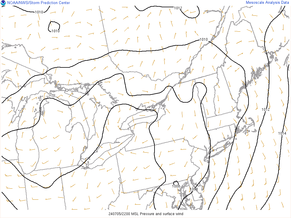

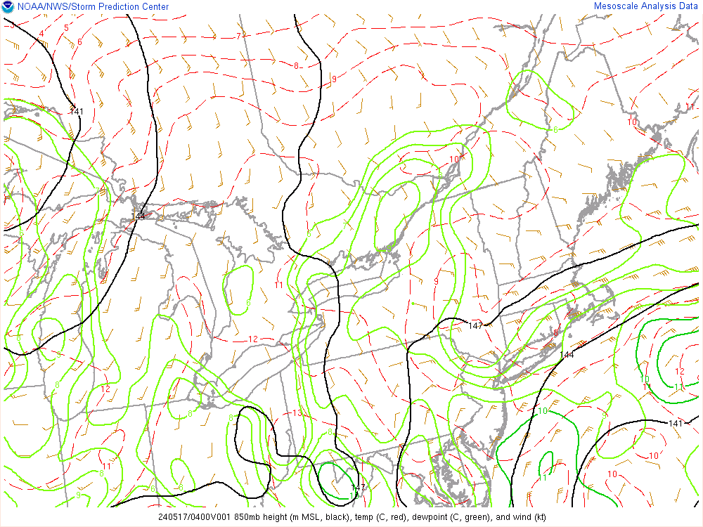
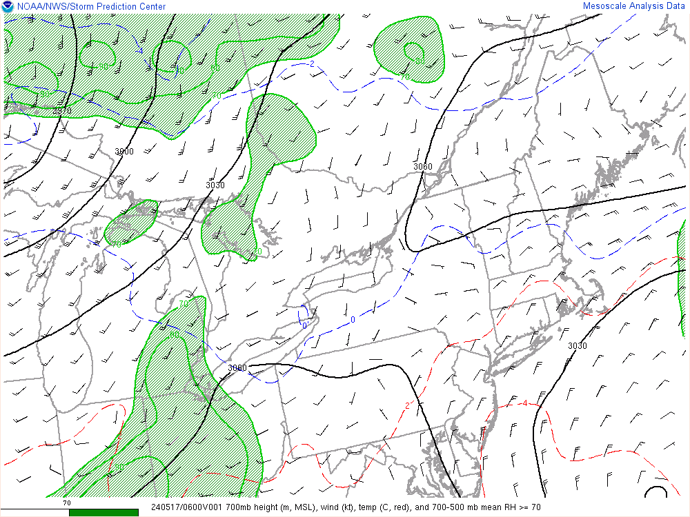
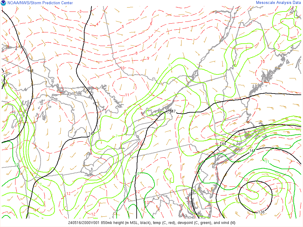
The reason for this is that the deformation band sets up shop to the NW of the 850mb and 700mb closed circulation. If I am not mistaken if those levels of the atmosphere were open the precip would be much further towards the coast right now. Here is the 850mb and 700mb closed Low position respectively. Notice they are not quite vertically stacked but rather each successive layer in the atmosphere, from surface to 850mb to 700mb, the closed circulation centers are layered from E/SE to W/NW. Notice where the def band is with respect to the 700mb low (NW Quadrant)
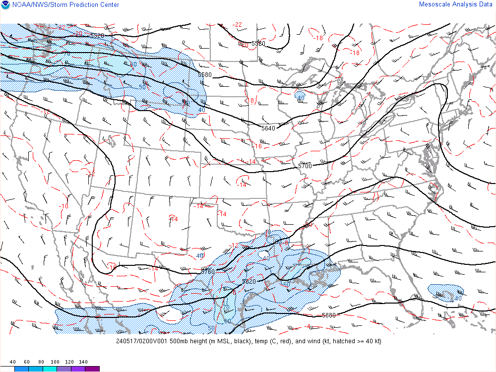
Now the million dollar question is when or if the 500mb layer closes off. Here is the current analysis at 500mb
Notice this little area of convection firing up around the Va/NC border. Here is the link for the loop:
http://mapmaker.aos.wisc.edu/scr3/sat/g8/g8wvflash.html
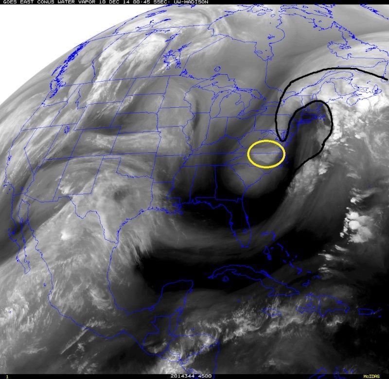 " />
" />This could be an indication that 500mb is trying to close off. If it does it should start to tug at the system and begin all sorts of craziness to the track that the Euro has been showing over the last few days. Def a now cast for crashing 850's and precip (notice in the image above the slow movement of the 0*C line is headed towards the coast again.) going into Wed and wed night
_________________
"In weather and in life, there's no winning and losing; there's only winning and learning."
WINTER 2012/2013 TOTALS 43.65"WINTER 2017/2018 TOTALS 62.85" WINTER 2022/2023 TOTALS 4.9"
WINTER 2013/2014 TOTALS 64.85"WINTER 2018/2019 TOTALS 14.25" WINTER 2023/2024 TOTALS 13.1"
WINTER 2014/2015 TOTALS 71.20"WINTER 2019/2020 TOTALS 6.35"
WINTER 2015/2016 TOTALS 35.00"WINTER 2020/2021 TOTALS 37.75"
WINTER 2016/2017 TOTALS 42.25"WINTER 2021/2022 TOTALS 31.65"

sroc4- Admin

- Posts : 8331
Reputation : 301
Join date : 2013-01-07
Location : Wading River, LI
Re: 12/9-12/10 Coastal Storm Observations
![]() by LB3147 Tue Dec 09, 2014 8:55 pm
by LB3147 Tue Dec 09, 2014 8:55 pm
LB3147- Posts : 31
Reputation : 0
Join date : 2014-11-11
Re: 12/9-12/10 Coastal Storm Observations
![]() by algae888 Tue Dec 09, 2014 9:05 pm
by algae888 Tue Dec 09, 2014 9:05 pm

algae888- Advanced Forecaster
- Posts : 5311
Reputation : 46
Join date : 2013-02-05
Age : 61
Location : mt. vernon, new york
Re: 12/9-12/10 Coastal Storm Observations
![]() by Frank_Wx Tue Dec 09, 2014 9:46 pm
by Frank_Wx Tue Dec 09, 2014 9:46 pm
_________________
_______________________________________________________________________________________________________
CLICK HERE to view NJ Strong Snowstorm Classifications

Frank_Wx- Godzilla Seeker
- Posts : 21305
Reputation : 328
Join date : 2013-01-05
Age : 31
Location : Jersey City, NJ -

Re: 12/9-12/10 Coastal Storm Observations
![]() by Dunnzoo Tue Dec 09, 2014 9:52 pm
by Dunnzoo Tue Dec 09, 2014 9:52 pm
_________________
Janet
Snowfall winter of 2023-2024 17.5"
Snowfall winter of 2022-2023 6.0"
Snowfall winter of 2021-2022 17.6" 1" sleet 2/25/22
Snowfall winter of 2020-2021 51.1"
Snowfall winter of 2019-2020 8.5"
Snowfall winter of 2018-2019 25.1"
Snowfall winter of 2017-2018 51.9"
Snowfall winter of 2016-2017 45.6"
Snowfall winter of 2015-2016 29.5"
Snowfall winter of 2014-2015 50.55"
Snowfall winter of 2013-2014 66.5"

Dunnzoo- Senior Enthusiast - Mod
- Posts : 4886
Reputation : 68
Join date : 2013-01-11
Age : 62
Location : Westwood, NJ
Re: 12/9-12/10 Coastal Storm Observations
![]() by essexcountypete Tue Dec 09, 2014 9:54 pm
by essexcountypete Tue Dec 09, 2014 9:54 pm
DON`T HAVE REALLY HIGH CONFIDENCE IN WHAT FORM OF PRECIP OR WHERE IT MAY OCCUR OVER THE FCST AREA TONIGHT.

essexcountypete- Pro Enthusiast

- Posts : 783
Reputation : 12
Join date : 2013-12-09
Location : Bloomfield, NJ
Re: 12/9-12/10 Coastal Storm Observations
![]() by Frank_Wx Tue Dec 09, 2014 9:56 pm
by Frank_Wx Tue Dec 09, 2014 9:56 pm
essexcountypete wrote:I think Mt Holly sums it up well...
DON`T HAVE REALLY HIGH CONFIDENCE IN WHAT FORM OF PRECIP OR WHERE IT MAY OCCUR OVER THE FCST AREA TONIGHT.
This storm was a nightmare for every forecaster known to man. Seriously.
_________________
_______________________________________________________________________________________________________
CLICK HERE to view NJ Strong Snowstorm Classifications
Frank_Wx- Godzilla Seeker
- Posts : 21305
Reputation : 328
Join date : 2013-01-05
Age : 31
Location : Jersey City, NJ -
Re: 12/9-12/10 Coastal Storm Observations
![]() by sroc4 Tue Dec 09, 2014 10:04 pm
by sroc4 Tue Dec 09, 2014 10:04 pm
LB3147 wrote:sroc great heads up.....wuts ur take? cud snowweenies be looking at sumthing similar the euro was showing a couple of days ago and maybe NYC/coast gets sum unexpected snow accumulations?
Honestly I have no idea how it all shakes out. This is an extremely complex set up and I am relying on observations at this point. I def think that areas along the NJ Coast, NYC and western LI have a chance to see some light accum, but I think its more isolated vs widespread from Wed afternoon into the evening. We are just going to have to watch closely.
@ Al. Im not sure what to make of that little area that is trying to close off at 500mb over S Dakota. We will see if it has any influence at all. There is so much going on at all levels of the atmosphere that it goes beyond my level of expertise. Like I said before I am looking at current observations and trying to predict how it shakes out. Watch the 850mb freezing line over the next 12 hrs; watch to see if the 500mb closes off. and watch to see what happens to the tracks of the closed circulations from the surface to 700mb if it does and hence where I believe unexpected bands of precip will form(squalls) in a relatively short periods of time. A true nowcast!
_________________
"In weather and in life, there's no winning and losing; there's only winning and learning."
WINTER 2012/2013 TOTALS 43.65"WINTER 2017/2018 TOTALS 62.85" WINTER 2022/2023 TOTALS 4.9"
WINTER 2013/2014 TOTALS 64.85"WINTER 2018/2019 TOTALS 14.25" WINTER 2023/2024 TOTALS 13.1"
WINTER 2014/2015 TOTALS 71.20"WINTER 2019/2020 TOTALS 6.35"
WINTER 2015/2016 TOTALS 35.00"WINTER 2020/2021 TOTALS 37.75"
WINTER 2016/2017 TOTALS 42.25"WINTER 2021/2022 TOTALS 31.65"
sroc4- Admin
- Posts : 8331
Reputation : 301
Join date : 2013-01-07
Location : Wading River, LI
Re: 12/9-12/10 Coastal Storm Observations
![]() by sroc4 Tue Dec 09, 2014 10:08 pm
by sroc4 Tue Dec 09, 2014 10:08 pm
essexcountypete wrote:I think Mt Holly sums it up well...
DON`T HAVE REALLY HIGH CONFIDENCE IN WHAT FORM OF PRECIP OR WHERE IT MAY OCCUR OVER THE FCST AREA TONIGHT.
That's awesome! Makes me feel better for saying I have no clue..lol
_________________
"In weather and in life, there's no winning and losing; there's only winning and learning."
WINTER 2012/2013 TOTALS 43.65"WINTER 2017/2018 TOTALS 62.85" WINTER 2022/2023 TOTALS 4.9"
WINTER 2013/2014 TOTALS 64.85"WINTER 2018/2019 TOTALS 14.25" WINTER 2023/2024 TOTALS 13.1"
WINTER 2014/2015 TOTALS 71.20"WINTER 2019/2020 TOTALS 6.35"
WINTER 2015/2016 TOTALS 35.00"WINTER 2020/2021 TOTALS 37.75"
WINTER 2016/2017 TOTALS 42.25"WINTER 2021/2022 TOTALS 31.65"
sroc4- Admin
- Posts : 8331
Reputation : 301
Join date : 2013-01-07
Location : Wading River, LI
Re: 12/9-12/10 Coastal Storm Observations
![]() by sroc4 Tue Dec 09, 2014 10:11 pm
by sroc4 Tue Dec 09, 2014 10:11 pm
_________________
"In weather and in life, there's no winning and losing; there's only winning and learning."
WINTER 2012/2013 TOTALS 43.65"WINTER 2017/2018 TOTALS 62.85" WINTER 2022/2023 TOTALS 4.9"
WINTER 2013/2014 TOTALS 64.85"WINTER 2018/2019 TOTALS 14.25" WINTER 2023/2024 TOTALS 13.1"
WINTER 2014/2015 TOTALS 71.20"WINTER 2019/2020 TOTALS 6.35"
WINTER 2015/2016 TOTALS 35.00"WINTER 2020/2021 TOTALS 37.75"
WINTER 2016/2017 TOTALS 42.25"WINTER 2021/2022 TOTALS 31.65"
sroc4- Admin
- Posts : 8331
Reputation : 301
Join date : 2013-01-07
Location : Wading River, LI
Re: 12/9-12/10 Coastal Storm Observations
![]() by amugs Tue Dec 09, 2014 10:14 pm
by amugs Tue Dec 09, 2014 10:14 pm
http://kamala.cod.edu/nj/latest.fxus61.KOKX.html
Cliff notes saying dusting/ snow showers coastal plain, NYC
N and W 2-4"
_________________
Mugs
AKA:King: Snow Weenie
Self Proclaimed
WINTER 2014-15 : 55.12" +.02 for 6 coatings (avg. 35")
WINTER 2015-16 Total - 29.8" (Avg 35")
WINTER 2016-17 : 39.5" so far

amugs- Advanced Forecaster - Mod
- Posts : 15093
Reputation : 213
Join date : 2013-01-07
Age : 54
Location : Hillsdale,NJ
Re: 12/9-12/10 Coastal Storm Observations
![]() by Frank_Wx Tue Dec 09, 2014 10:18 pm
by Frank_Wx Tue Dec 09, 2014 10:18 pm


_________________
_______________________________________________________________________________________________________
CLICK HERE to view NJ Strong Snowstorm Classifications
Frank_Wx- Godzilla Seeker
- Posts : 21305
Reputation : 328
Join date : 2013-01-05
Age : 31
Location : Jersey City, NJ -
Re: 12/9-12/10 Coastal Storm Observations
![]() by Frank_Wx Tue Dec 09, 2014 10:18 pm
by Frank_Wx Tue Dec 09, 2014 10:18 pm
_________________
_______________________________________________________________________________________________________
CLICK HERE to view NJ Strong Snowstorm Classifications
Frank_Wx- Godzilla Seeker
- Posts : 21305
Reputation : 328
Join date : 2013-01-05
Age : 31
Location : Jersey City, NJ -
Re: 12/9-12/10 Coastal Storm Observations
![]() by essexcountypete Tue Dec 09, 2014 10:19 pm
by essexcountypete Tue Dec 09, 2014 10:19 pm
sroc4 wrote:essexcountypete wrote:I think Mt Holly sums it up well...
DON`T HAVE REALLY HIGH CONFIDENCE IN WHAT FORM OF PRECIP OR WHERE IT MAY OCCUR OVER THE FCST AREA TONIGHT.
That's awesome! Makes me feel better for saying I have no clue..lol
Yeah, nice to know that with all the knowledge even the experts can always make sense of it all, and I give them credit for admitting it. As Frank said, this one was tough.
essexcountypete- Pro Enthusiast
- Posts : 783
Reputation : 12
Join date : 2013-12-09
Location : Bloomfield, NJ
Re: 12/9-12/10 Coastal Storm Observations
![]() by Frank_Wx Tue Dec 09, 2014 10:34 pm
by Frank_Wx Tue Dec 09, 2014 10:34 pm

_________________
_______________________________________________________________________________________________________
CLICK HERE to view NJ Strong Snowstorm Classifications
Frank_Wx- Godzilla Seeker
- Posts : 21305
Reputation : 328
Join date : 2013-01-05
Age : 31
Location : Jersey City, NJ -
Re: 12/9-12/10 Coastal Storm Observations
![]() by NjWeatherGuy Tue Dec 09, 2014 10:47 pm
by NjWeatherGuy Tue Dec 09, 2014 10:47 pm
Frank_Wx wrote:00z GFS still popping some snow showers in NW NJ and NEPA tomorrow afternoon
Rotates down and chances for snow showers thru about hr 54 if im reading the GFS right.
NjWeatherGuy- Advanced Forecaster
- Posts : 4100
Reputation : 28
Join date : 2013-01-06
Location : Belle Mead, NJ
Re: 12/9-12/10 Coastal Storm Observations
![]() by Frank_Wx Tue Dec 09, 2014 10:52 pm
by Frank_Wx Tue Dec 09, 2014 10:52 pm
_________________
_______________________________________________________________________________________________________
CLICK HERE to view NJ Strong Snowstorm Classifications
Frank_Wx- Godzilla Seeker
- Posts : 21305
Reputation : 328
Join date : 2013-01-05
Age : 31
Location : Jersey City, NJ -
Re: 12/9-12/10 Coastal Storm Observations
![]() by rb924119 Tue Dec 09, 2014 11:31 pm
by rb924119 Tue Dec 09, 2014 11:31 pm
rb924119- Meteorologist

- Posts : 6889
Reputation : 194
Join date : 2013-02-06
Age : 32
Location : Greentown, Pa
Re: 12/9-12/10 Coastal Storm Observations
![]() by rb924119 Tue Dec 09, 2014 11:36 pm
by rb924119 Tue Dec 09, 2014 11:36 pm
rb924119- Meteorologist
- Posts : 6889
Reputation : 194
Join date : 2013-02-06
Age : 32
Location : Greentown, Pa
Page 6 of 10 • 1, 2, 3, 4, 5, 6, 7, 8, 9, 10 ![]()
|
|
|