
 Search
Official Long Range Thread 5.0
Page 5 of 40 •  1, 2, 3, 4, 5, 6 ... 22 ... 40
 ![]()
Re: Official Long Range Thread 5.0
![]() by Dunnzoo Tue Dec 16, 2014 12:38 am
by Dunnzoo Tue Dec 16, 2014 12:38 am
Dunnzoo- Senior Enthusiast - Mod

- Posts : 4892
Join date : 2013-01-11
Re: Official Long Range Thread 5.0
![]() by Frank_Wx Tue Dec 16, 2014 11:03 am
by Frank_Wx Tue Dec 16, 2014 11:03 am
Frank_Wx- Godzilla Seeker

- Posts : 21305
Join date : 2013-01-05 -

Re: Official Long Range Thread 5.0
![]() by Frank_Wx Tue Dec 16, 2014 1:44 pm
by Frank_Wx Tue Dec 16, 2014 1:44 pm
_________________
_______________________________________________________________________________________________________
CLICK HERE to view NJ Strong Snowstorm Classifications

Frank_Wx- Godzilla Seeker
- Posts : 21305
Reputation : 328
Join date : 2013-01-05
Age : 31
Location : Jersey City, NJ -
Re: Official Long Range Thread 5.0
![]() by nutleyblizzard Tue Dec 16, 2014 1:59 pm
by nutleyblizzard Tue Dec 16, 2014 1:59 pm
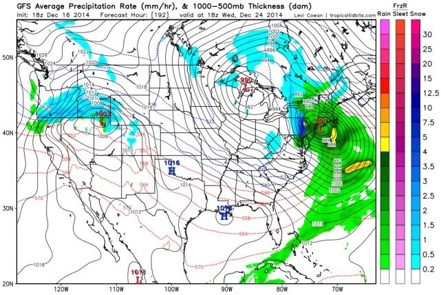
It's a cutter. We need that pattern change to have these storms produce good snows down to the coast. Until that happens, I fear we will have continued heartbreaks with these systems.Frank_Wx wrote:EURO still showing a large storm around X-mas Eve. Signal is there.

nutleyblizzard- Senior Enthusiast

- Posts : 1952
Reputation : 41
Join date : 2014-01-30
Age : 58
Location : Nutley, new jersey
Re: Official Long Range Thread 5.0
![]() by skinsfan1177 Tue Dec 16, 2014 2:53 pm
by skinsfan1177 Tue Dec 16, 2014 2:53 pm

skinsfan1177- Senior Enthusiast
- Posts : 4485
Reputation : 35
Join date : 2013-01-07
Age : 46
Location : Point Pleasant Boro
Re: Official Long Range Thread 5.0
![]() by Frank_Wx Tue Dec 16, 2014 3:07 pm
by Frank_Wx Tue Dec 16, 2014 3:07 pm
skinsfan1177 wrote:I thought in the long range models where showing the trough in the east and ridge out west and the signal where going in the right direction.
They are, but the transition period (18th-24th) has 2 storms that can go either way.
Anything after the 25th I think has a good chance of bring white than wet.
_________________
_______________________________________________________________________________________________________
CLICK HERE to view NJ Strong Snowstorm Classifications
Frank_Wx- Godzilla Seeker
- Posts : 21305
Reputation : 328
Join date : 2013-01-05
Age : 31
Location : Jersey City, NJ -
Re: Official Long Range Thread 5.0
![]() by skinsfan1177 Tue Dec 16, 2014 3:29 pm
by skinsfan1177 Tue Dec 16, 2014 3:29 pm
Frank_Wx wrote:skinsfan1177 wrote:I thought in the long range models where showing the trough in the east and ridge out west and the signal where going in the right direction.
They are, but the transition period (18th-24th) has 2 storms that can go either way.
Anything after the 25th I think has a good chance of bring white than wet.
That sounds good I hope we get into a white pattern
skinsfan1177- Senior Enthusiast
- Posts : 4485
Reputation : 35
Join date : 2013-01-07
Age : 46
Location : Point Pleasant Boro
Re: Official Long Range Thread 5.0
![]() by Frank_Wx Tue Dec 16, 2014 8:41 pm
by Frank_Wx Tue Dec 16, 2014 8:41 pm

_________________
_______________________________________________________________________________________________________
CLICK HERE to view NJ Strong Snowstorm Classifications
Frank_Wx- Godzilla Seeker
- Posts : 21305
Reputation : 328
Join date : 2013-01-05
Age : 31
Location : Jersey City, NJ -
Re: Official Long Range Thread 5.0
![]() by NjWeatherGuy Tue Dec 16, 2014 8:52 pm
by NjWeatherGuy Tue Dec 16, 2014 8:52 pm
Gotta love these fantasy storms.

NjWeatherGuy- Advanced Forecaster

- Posts : 4100
Reputation : 28
Join date : 2013-01-06
Location : Belle Mead, NJ
Re: Official Long Range Thread 5.0
![]() by Frank_Wx Tue Dec 16, 2014 9:00 pm
by Frank_Wx Tue Dec 16, 2014 9:00 pm
_________________
_______________________________________________________________________________________________________
CLICK HERE to view NJ Strong Snowstorm Classifications
Frank_Wx- Godzilla Seeker
- Posts : 21305
Reputation : 328
Join date : 2013-01-05
Age : 31
Location : Jersey City, NJ -
Re: Official Long Range Thread 5.0
![]() by amugs Tue Dec 16, 2014 9:36 pm
by amugs Tue Dec 16, 2014 9:36 pm
Frank_Wx wrote:I think I mentioned in here last week that we have gone through 2 failed SSWE. I also brought it up in my latest blog. If we look ahead to our next SSWE, I think this one finally has a chance to come to fruition by the end of this month. The 18z GFS, from 10 mb to 70 mb, is showing a classic split of the PV. I said in my blog that the Stratosphere is not letting up until a successful SSWE occurs. All the analogs that ive seen, especially the ones from my winter outlook, had a SSWE occur in late Decembee to mid January. The state of the SAI and QBO support one, and once it does, we could be in for quite a ride.
Here at the 70 mb level too

_________________
Mugs
AKA:King: Snow Weenie
Self Proclaimed
WINTER 2014-15 : 55.12" +.02 for 6 coatings (avg. 35")
WINTER 2015-16 Total - 29.8" (Avg 35")
WINTER 2016-17 : 39.5" so far

amugs- Advanced Forecaster - Mod
- Posts : 15093
Reputation : 213
Join date : 2013-01-07
Age : 54
Location : Hillsdale,NJ
Re: Official Long Range Thread 5.0
![]() by amugs Tue Dec 16, 2014 9:38 pm
by amugs Tue Dec 16, 2014 9:38 pm
_________________
Mugs
AKA:King: Snow Weenie
Self Proclaimed
WINTER 2014-15 : 55.12" +.02 for 6 coatings (avg. 35")
WINTER 2015-16 Total - 29.8" (Avg 35")
WINTER 2016-17 : 39.5" so far
amugs- Advanced Forecaster - Mod
- Posts : 15093
Reputation : 213
Join date : 2013-01-07
Age : 54
Location : Hillsdale,NJ
Re: Official Long Range Thread 5.0
![]() by CPcantmeasuresnow Tue Dec 16, 2014 10:01 pm
by CPcantmeasuresnow Tue Dec 16, 2014 10:01 pm
It makes me long for the days where Tex Antoine would draw a Big L in the Gulf of Mexico and I'd get all excited thinking it was gonna take a run up the east coast which of course in my limited thinking meant a big snow storm. Ignorance is sometimes bliss.

CPcantmeasuresnow- Wx Statistician Guru

- Posts : 7274
Reputation : 230
Join date : 2013-01-07
Age : 103
Location : Eastern Orange County, NY
Re: Official Long Range Thread 5.0
![]() by Frank_Wx Wed Dec 17, 2014 12:04 am
by Frank_Wx Wed Dec 17, 2014 12:04 am

At least the GEFS maintain a strong, favorable signal post Xmas
_________________
_______________________________________________________________________________________________________
CLICK HERE to view NJ Strong Snowstorm Classifications
Frank_Wx- Godzilla Seeker
- Posts : 21305
Reputation : 328
Join date : 2013-01-05
Age : 31
Location : Jersey City, NJ -
Re: Official Long Range Thread 5.0
![]() by Frank_Wx Wed Dec 17, 2014 12:13 am
by Frank_Wx Wed Dec 17, 2014 12:13 am

_________________
_______________________________________________________________________________________________________
CLICK HERE to view NJ Strong Snowstorm Classifications
Frank_Wx- Godzilla Seeker
- Posts : 21305
Reputation : 328
Join date : 2013-01-05
Age : 31
Location : Jersey City, NJ -
Re: Official Long Range Thread 5.0
![]() by sroc4 Wed Dec 17, 2014 6:10 am
by sroc4 Wed Dec 17, 2014 6:10 am
_________________
"In weather and in life, there's no winning and losing; there's only winning and learning."
WINTER 2012/2013 TOTALS 43.65"WINTER 2017/2018 TOTALS 62.85" WINTER 2022/2023 TOTALS 4.9"
WINTER 2013/2014 TOTALS 64.85"WINTER 2018/2019 TOTALS 14.25" WINTER 2023/2024 TOTALS 13.1"
WINTER 2014/2015 TOTALS 71.20"WINTER 2019/2020 TOTALS 6.35"
WINTER 2015/2016 TOTALS 35.00"WINTER 2020/2021 TOTALS 37.75"
WINTER 2016/2017 TOTALS 42.25"WINTER 2021/2022 TOTALS 31.65"

sroc4- Admin
- Posts : 8331
Reputation : 301
Join date : 2013-01-07
Location : Wading River, LI
Re: Official Long Range Thread 5.0
![]() by jmanley32 Wed Dec 17, 2014 6:27 am
by jmanley32 Wed Dec 17, 2014 6:27 am

jmanley32- Senior Enthusiast
- Posts : 20517
Reputation : 108
Join date : 2013-12-12
Age : 42
Location : Yonkers, NY
Re: Official Long Range Thread 5.0
![]() by sroc4 Wed Dec 17, 2014 6:27 am
by sroc4 Wed Dec 17, 2014 6:27 am
_________________
"In weather and in life, there's no winning and losing; there's only winning and learning."
WINTER 2012/2013 TOTALS 43.65"WINTER 2017/2018 TOTALS 62.85" WINTER 2022/2023 TOTALS 4.9"
WINTER 2013/2014 TOTALS 64.85"WINTER 2018/2019 TOTALS 14.25" WINTER 2023/2024 TOTALS 13.1"
WINTER 2014/2015 TOTALS 71.20"WINTER 2019/2020 TOTALS 6.35"
WINTER 2015/2016 TOTALS 35.00"WINTER 2020/2021 TOTALS 37.75"
WINTER 2016/2017 TOTALS 42.25"WINTER 2021/2022 TOTALS 31.65"
sroc4- Admin
- Posts : 8331
Reputation : 301
Join date : 2013-01-07
Location : Wading River, LI
Re: Official Long Range Thread 5.0
![]() by amugs Wed Dec 17, 2014 7:54 am
by amugs Wed Dec 17, 2014 7:54 am
CPcantmeasuresnow wrote:Pretty complex stuff Mugs.
It makes me long for the days where Tex Antoine would draw a Big L in the Gulf of Mexico and I'd get all excited thinking it was gonna take a run up the east coast which of course in my limited thinking meant a big snow storm. Ignorance is sometimes bliss.
Oh Tex what a great met and I to what get all excited when he did that - I know and then he would say after he drew it track up the coast 'folks this is going to be a rainmaker" POOOOOF!!!
_________________
Mugs
AKA:King: Snow Weenie
Self Proclaimed
WINTER 2014-15 : 55.12" +.02 for 6 coatings (avg. 35")
WINTER 2015-16 Total - 29.8" (Avg 35")
WINTER 2016-17 : 39.5" so far
amugs- Advanced Forecaster - Mod
- Posts : 15093
Reputation : 213
Join date : 2013-01-07
Age : 54
Location : Hillsdale,NJ
Re: Official Long Range Thread 5.0
![]() by sroc4 Wed Dec 17, 2014 8:06 am
by sroc4 Wed Dec 17, 2014 8:06 am
_________________
"In weather and in life, there's no winning and losing; there's only winning and learning."
WINTER 2012/2013 TOTALS 43.65"WINTER 2017/2018 TOTALS 62.85" WINTER 2022/2023 TOTALS 4.9"
WINTER 2013/2014 TOTALS 64.85"WINTER 2018/2019 TOTALS 14.25" WINTER 2023/2024 TOTALS 13.1"
WINTER 2014/2015 TOTALS 71.20"WINTER 2019/2020 TOTALS 6.35"
WINTER 2015/2016 TOTALS 35.00"WINTER 2020/2021 TOTALS 37.75"
WINTER 2016/2017 TOTALS 42.25"WINTER 2021/2022 TOTALS 31.65"
sroc4- Admin
- Posts : 8331
Reputation : 301
Join date : 2013-01-07
Location : Wading River, LI
Re: Official Long Range Thread 5.0
![]() by amugs Wed Dec 17, 2014 9:11 am
by amugs Wed Dec 17, 2014 9:11 am
sroc4 wrote:I know Frank Locked the Sunday storm thread but I have a hunch we will be reopening it by tomorrow morning. The system that will interact with the STJ looks very robust(the swirl headed S towards NW Cali. Notice the blue to the east and the black to the west side of it. If it comes ashore today and tonight a cont to be strong the models will adjust and we will see a stronger interaction along the EC. In theory of course. Again the timing is everything. My point is its not looking good on models, but current observations say give it till tomorrow 12z to lay it to rest officially. For the record I am still not looking at a blockbuster, but a colder minor snowy soln still has a chance.
Doc - I said this in Banter Thread wait until tomorrow to put this to rest - looking for minor event 1-3" possibly - must be the Itralian in both of us??
Check this out - two huge deep lows in the PAC - they are going to effect us one way or the other!
I am calling for a MECS/HECS Jan 7-10th - 1996 redux or comparable - these are the storms that may be it using the SOJ (Sea of Japan) theory 16-21 days to affect the east coast -more success in a nino year from some research I have read - storm wise and hey my Bearing Sea Rule call looks to happen as well for xmas timeframe
_________________
Mugs
AKA:King: Snow Weenie
Self Proclaimed
WINTER 2014-15 : 55.12" +.02 for 6 coatings (avg. 35")
WINTER 2015-16 Total - 29.8" (Avg 35")
WINTER 2016-17 : 39.5" so far
amugs- Advanced Forecaster - Mod
- Posts : 15093
Reputation : 213
Join date : 2013-01-07
Age : 54
Location : Hillsdale,NJ
Re: Official Long Range Thread 5.0
![]() by Snow88 Wed Dec 17, 2014 9:34 am
by Snow88 Wed Dec 17, 2014 9:34 am

Snow88- Senior Enthusiast
- Posts : 2193
Reputation : 4
Join date : 2013-01-09
Age : 35
Location : Brooklyn, NY
Re: Official Long Range Thread 5.0
![]() by sroc4 Wed Dec 17, 2014 9:42 am
by sroc4 Wed Dec 17, 2014 9:42 am
If the pre Xmas storm is stronger then what everyone thinks it just might. Could you imagine a 968mb low at the BM on Xmas eve? How would Santa make it in one night?Snow88 wrote:Imagine if the Christmas cutter becomes a coastal storm. Wowza.
_________________
"In weather and in life, there's no winning and losing; there's only winning and learning."
WINTER 2012/2013 TOTALS 43.65"WINTER 2017/2018 TOTALS 62.85" WINTER 2022/2023 TOTALS 4.9"
WINTER 2013/2014 TOTALS 64.85"WINTER 2018/2019 TOTALS 14.25" WINTER 2023/2024 TOTALS 13.1"
WINTER 2014/2015 TOTALS 71.20"WINTER 2019/2020 TOTALS 6.35"
WINTER 2015/2016 TOTALS 35.00"WINTER 2020/2021 TOTALS 37.75"
WINTER 2016/2017 TOTALS 42.25"WINTER 2021/2022 TOTALS 31.65"
sroc4- Admin
- Posts : 8331
Reputation : 301
Join date : 2013-01-07
Location : Wading River, LI
Re: Official Long Range Thread 5.0
![]() by Frank_Wx Wed Dec 17, 2014 10:08 am
by Frank_Wx Wed Dec 17, 2014 10:08 am
_________________
_______________________________________________________________________________________________________
CLICK HERE to view NJ Strong Snowstorm Classifications
Frank_Wx- Godzilla Seeker
- Posts : 21305
Reputation : 328
Join date : 2013-01-05
Age : 31
Location : Jersey City, NJ -
Re: Official Long Range Thread 5.0
![]() by jmanley32 Wed Dec 17, 2014 10:17 am
by jmanley32 Wed Dec 17, 2014 10:17 am
jmanley32- Senior Enthusiast
- Posts : 20517
Reputation : 108
Join date : 2013-12-12
Age : 42
Location : Yonkers, NY
Re: Official Long Range Thread 5.0
![]() by tigernumba1 Wed Dec 17, 2014 10:19 am
by tigernumba1 Wed Dec 17, 2014 10:19 am

tigernumba1- Posts : 298
Reputation : 1
Join date : 2013-11-22
Age : 29
Location : East Northport, NY, 11731
Re: Official Long Range Thread 5.0
![]() by Frank_Wx Wed Dec 17, 2014 10:26 am
by Frank_Wx Wed Dec 17, 2014 10:26 am
jmanley32 wrote:Is there a chance that the xmas storm moves that far east and becomes a coastal, it kinda confuses me on surface models as it looks like a drawn out bunch of LP all lumped together.
Doubt it. Transition storms tend not to favor the east coast. Right now my forecast for Xmas eve is rain. But worth watching for sure just because of the magnitude of the storm and of course the day its expected to come.
tigernumba1 wrote:The polar jet stream looks like its really going to deepen around christmas time, whereas its more flat for this weekends storm. Won't that help in bringing enough cold air to support snow?
Oh yea. The period after Xmas looks really good. In the Dec. 20th-Jan. 10th time frame I've been preaching since Thanksgiving, it's clear Dec. 20th-24th is the transition period to our winter pattern and Dec. 25th and beyond we should be ready to rock
_________________
_______________________________________________________________________________________________________
CLICK HERE to view NJ Strong Snowstorm Classifications
Frank_Wx- Godzilla Seeker
- Posts : 21305
Reputation : 328
Join date : 2013-01-05
Age : 31
Location : Jersey City, NJ -
Page 5 of 40 • 1, 2, 3, 4, 5, 6 ... 22 ... 40 ![]()
|
|
|