
 Search
Official Long Range Thread 5.0
Page 24 of 40 •  1 ... 13 ... 23, 24, 25 ... 32 ... 40
 ![]()
Re: Official Long Range Thread 5.0
![]() by Frank_Wx Wed Dec 31, 2014 1:42 am
by Frank_Wx Wed Dec 31, 2014 1:42 am

Frank_Wx- Godzilla Seeker

- Posts : 21305
Join date : 2013-01-05 -

Re: Official Long Range Thread 5.0
![]() by Artechmetals Wed Dec 31, 2014 2:17 am
by Artechmetals Wed Dec 31, 2014 2:17 am
Artechmetals- Pro Enthusiast

- Posts : 571
Join date : 2014-01-01
Re: Official Long Range Thread 5.0
![]() by algae888 Wed Dec 31, 2014 4:22 am
by algae888 Wed Dec 31, 2014 4:22 am
LATEST OPERATIONAL ECMWF/CMC/GFS/UKMET AND RESPECTIVE ENSEMBLE MEANS
IN GOOD AGREEMENT WITH A SOMEWHAT PHASED NORTHERN AND SOUTHERN
STREAM...WITH STRONG SHORTWAVE ENERGY EJECTING OUT OF THE SOUTHWEST
INTO THE NORTHEAST THIS WEEKEND...AS STRONG PAC ENERGY DIGS THE JET STREAM
DOWN INTO THE SOUTH CENTRAL US. SOME SUBTLE TIMING AND TRACK
DIFFERENCES EXIST IN THE EJECTING SHORTWAVE...WITH MORE DIFFERENCE
IN STRENGTH BASED ON DEGREE OF PHASING. THIS REFLECTS IN SIMILAR
DIFFERENCES IN SURFACE LOW PRESSURE.
SBU CSTAR SENSITIVITY ANALYSIS INDICATING THE ABOVE UNCERTAINTY
LIES MORE SO WITH THE STRENGTH OF PAC SHORTWAVE ENERGY RIDING OVER
EASTERN PACIFIC RIDGING...AND SECONDLY WITH SOUTHWESTERN SHORTWAVE
ENERGY. A STRONGER PAC SHORTWAVE ULTIMATELY LEADING TO MORE
PHASING OF ENERGIES AND A STRONGER LOW.
WITH THAT SAID...MEAN SYNOPTIC PATTERN INDICATING PRIMARY LOW
PRESSURE SYSTEM TRACKING UP THROUGH THE GREAT LAKES/WESTERN NY
INTO QUEBEC/NEW ENGLAND SAT NIGHT INTO SUN...WITH WEAKER SECONDARY
DEVELOPMENT ALONG THE COASTAL PLAIN. ALL WHILE ARCTIC HIGH
PRESSURE SLOWLY RETREATS. WITH PREVIOUS FORECAST ALREADY LEANING IN
THAT DIRECTION...HAVE CONTINUED TO TREND FORECAST TO ABOVE
THINKING.
THIS SCENARIO SHOULD BE FAVORABLE FOR SNOW/WINTRY MIX TRANSITIONING
TO FREEZING RAIN/RAIN (INTERIOR) AND RAIN(COAST)SAT NIGHT...BEFORE
PRECIP TAPERS OFF SUNDAY MORNING. A PERIOD OF HEAVY PRECIP POSSIBLE
SAT NIGHT WITH STRONG WAA AND GULF CONNECTION BRINGING IN PWATS OF
2 TO 3 STDS ABOVE NORMAL. SOME OF WHICH COULD BE HEAVY SNOW ACROSS
INTERIOR. WAA WOULD CHANGE ANY PRECIP TO LIQUID OVERNIGHT
SAT...BUT DEPENDING ON EVOLUTION OF COASTAL LOW...SURFACE COLD AIR
MAY BE TOUGH TO SCOUR OUT OF INTERIOR NW VALLEYS RESULTING IN SOME
ICING ISSUES.

algae888- Advanced Forecaster

- Posts : 5311
Reputation : 46
Join date : 2013-02-05
Age : 61
Location : mt. vernon, new york
Re: Official Long Range Thread 5.0
![]() by sroc4 Wed Dec 31, 2014 7:25 am
by sroc4 Wed Dec 31, 2014 7:25 am
HectorO wrote:Frank_Wx wrote:SoulSingMG wrote:Frank_Wx wrote:SoulSingMG wrote:This is how it works during El Niño.
Not at all. This has been far from a Nino pattern. It's closer to La Nina
I thought La Niña is when we see more snow and El Niño is less? Forgive me, I was living in LA during the last El Niño (when they received more rain in one month than in like 50 years)...Constant mudslides, flooding, was nuts.
Typically we see bigger storms during El Niño and more lighter events during la nina.
True, but we have seen quite a few good La Nina events also. More recent was 10/11
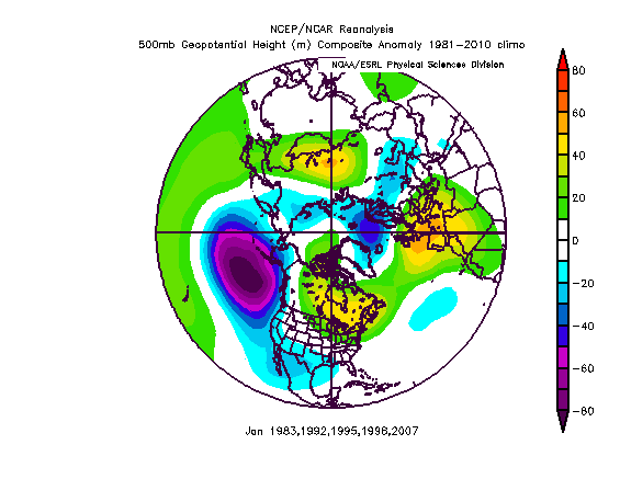
Lets make something very clear WE ARE NOT IN A La Nina Pattern. La nina is defined by cooler than normal Waters in the tropical Pac , which is NOT the case here. Just like a mod to strong El Nino a mod to strong La Nina tends to be a strong or primary driver to the overall pattern. That being said there is no questioning the fact that we have a weak El Nino in place, but clearly it has not been a major driver to the pattern; but rather a small part to the the sum of all the parts which has led to an anomalously cold Nov followed by a warm Dec. and the first 8-10 days are looking to be below normal temp wise. Here is a good post by Isotherm in another forum discussing some of the the El Nino analogues.
"The 500mb composite for warmer than normal El Nino Januarys since 1975 denotes a strong +EPO / +AO / +NAO pattern with the mean ridge located over SE Canada:
 " />
" />Progged pattern for the first 5 days of January at H5:
 " />
" />Progged pattern for the Jan 5-10th period at H5:
 " />
" />Temperature departures for the warm Nino year Januarys:
 " />
" />Point being, the first 10 days of January don't appear to be following the warm "camp" of analogs for El Nino years, with the most notable difference being the polar opposite NPAC/AK EPO signature.
For El Nino's, the time of divergence among years tends to occur in January, that is, we're entering a very telling period in terms of the ultimate fate of the winter. Warm El Ninos tended to continue to blowtorch from December through much of January. Cold El Ninos like 1976, 2002, and 2009, stayed cold for most of the DJF period. Transition El Nino's like 2004, 1986 and 1987 featured a warm Dec and much colder January and February
So this winter will be showing its cards shortly, and at least for the next 10 days, it doesn't appear to be moving toward the wire to wire warmth analog camp."
_________________
"In weather and in life, there's no winning and losing; there's only winning and learning."
WINTER 2012/2013 TOTALS 43.65"WINTER 2017/2018 TOTALS 62.85" WINTER 2022/2023 TOTALS 4.9"
WINTER 2013/2014 TOTALS 64.85"WINTER 2018/2019 TOTALS 14.25" WINTER 2023/2024 TOTALS 13.1"
WINTER 2014/2015 TOTALS 71.20"WINTER 2019/2020 TOTALS 6.35"
WINTER 2015/2016 TOTALS 35.00"WINTER 2020/2021 TOTALS 37.75"
WINTER 2016/2017 TOTALS 42.25"WINTER 2021/2022 TOTALS 31.65"

sroc4- Admin
- Posts : 8331
Reputation : 301
Join date : 2013-01-07
Location : Wading River, LI
Re: Official Long Range Thread 5.0
![]() by sroc4 Wed Dec 31, 2014 8:04 am
by sroc4 Wed Dec 31, 2014 8:04 am

Here is the stat line for snow fall totals for 2004-2005
2004-05 : Dec 3.0 Jan 15.3 Feb 15.8 March 6.9 Total = 41.0
CP as far as your Dec indicator it is right on the cusp with 3". Now I am sorry my friend but there are huge flaws in that statistic. You must break down for me some of the other major pattern drivers, and more importantly deciding which of those factors or combinations of were responsible for driving the overall pattern during all the years that were under your Dec snow criteria vs above. In addition we need to know the physical drivers that were responsible for the overall pattern during those years as well as the years that have bucked your trend (Ie: such as the state of the ENSO, MJO, EPO, AO, NAO, PDO, AMO, PNA, QBO, SOI, SST Pac/Atl Strat warming events, solar cycles, etc etc etc)
Until this is broken down for me as such this Dec prognosticator, esp for this year, has no statistical relevance to me. My analogy to this prognostic indicator would be this:
A dog with Cushings disease is one characterized by an excessive amount of a steroidal hormone circulating in the blood called cortisol. Cortisol is one of many stress hormones that goes up in the body when under stress. (All of our cortisol levels have prob been slightly higher than normal up to this point). One of the symptoms we see in dogs with cushings is minor tomod skin infections and thinning hair. The owner will often bring the dog in because he/she has been chewing himself all over because of the infection. The result of all this biting/chewing, and licking is almost always leading to a skin infection, sometimes minor, sometimes moderate. The intensity of the biting and chewing is our Dec snow prognosticator index. One can argue that its the biting and chewing and how much or little chewing is taking place is what leads to the skin infection most if not all of the time. However if you dig deeper its actually the cortisol levels as well as other hormone levels that are also thrown off balance because of this anomalous level of cortisol. The higher than normal cortisol levels leads to disruption in the hair follicle growth cyle as well as a dampening/weakening of the immune system. As a result you have a dog that will sometimes develop an infection in his skin much easier than a dog without cushings disease. So this infection in the skin which was driven by the hormone level imbalances has now induced an immune response in the skin which results in inflammatory mediators(chemicals) which cause the dog to be itchy. Now he/she starts to bite at himself sometimes agressively sometimes not so much and makes the infection much worse and its snowballs from there.
So in reality with a dog with cushings it can be argued that the hormone levels are what drove the infection and the chewing was a result of it. It just so happens that once there are inflammatory mediators inciting the itch the biting and chewing that ensues will invariably lead to worsening of the infection to the point where the owner takes notice. Not all dogs with cushings; however, come in with skin issues but many do. Its the sum of all the other factors that will govern if a dog with cushings comes in with bad skin not if the dog bites or scratches himself.
If you can show me multiple years with even half of the current drivers we have in place then maybe I buy into it for this year. Until then I will continue to buy all of your winter stocks for pennies.
_________________
"In weather and in life, there's no winning and losing; there's only winning and learning."
WINTER 2012/2013 TOTALS 43.65"WINTER 2017/2018 TOTALS 62.85" WINTER 2022/2023 TOTALS 4.9"
WINTER 2013/2014 TOTALS 64.85"WINTER 2018/2019 TOTALS 14.25" WINTER 2023/2024 TOTALS 13.1"
WINTER 2014/2015 TOTALS 71.20"WINTER 2019/2020 TOTALS 6.35"
WINTER 2015/2016 TOTALS 35.00"WINTER 2020/2021 TOTALS 37.75"
WINTER 2016/2017 TOTALS 42.25"WINTER 2021/2022 TOTALS 31.65"
sroc4- Admin
- Posts : 8331
Reputation : 301
Join date : 2013-01-07
Location : Wading River, LI
Re: Official Long Range Thread 5.0
![]() by skinsfan1177 Wed Dec 31, 2014 8:17 am
by skinsfan1177 Wed Dec 31, 2014 8:17 am

skinsfan1177- Senior Enthusiast

- Posts : 4485
Reputation : 35
Join date : 2013-01-07
Age : 46
Location : Point Pleasant Boro
Re: Official Long Range Thread 5.0
![]() by algae888 Wed Dec 31, 2014 8:28 am
by algae888 Wed Dec 31, 2014 8:28 am
skinsfan1177 wrote:So let me understand something here janruary will not warm up or will it. Thought I read we will torch the month of jan or is it still up in the air I know the first week is cold but after I thought the warm up comes
skins from what I have been hearing we will be below normal through jan 10th or so. then we should warm for a brief period to normal or above before heading back below to close out the month. I do not trust what will happen after jan. 10th but for now expect below normal temps. next week could end up well below normal. however this doesn't mean we will get any snow. that's always a crap shoot


Last edited by algae888 on Wed Dec 31, 2014 8:34 am; edited 1 time in total
algae888- Advanced Forecaster
- Posts : 5311
Reputation : 46
Join date : 2013-02-05
Age : 61
Location : mt. vernon, new york
Re: Official Long Range Thread 5.0
![]() by Guest Wed Dec 31, 2014 8:33 am
by Guest Wed Dec 31, 2014 8:33 am
Frank_Wx wrote:You can clearly see the phasing taking place on the CMC model in the Midwest when it comes to the storm early next week. Polar and southern jet meet up. It looks very likely the storm next week will cut to our west, bringing rain to our area. Some snow or wintry precip is possible at the start, especially north and west of NYC
YES!! Awesome.
Guest- Guest
Re: Official Long Range Thread 5.0
![]() by sroc4 Wed Dec 31, 2014 8:57 am
by sroc4 Wed Dec 31, 2014 8:57 am
The post above is showing that of years past when El Niño years torch Jan they tend do so strait through dec into Jan. The post point out that the EPO is typically in the positive phase when Dec and Jan torches which is exactly the opposite of what we have now. So the point is most likely the warm up advertised after jan 10 will prob be less pronounced and shorter than currently advertised.skinsfan1177 wrote:So let me understand something here janruary will not warm up or will it. Thought I read we will torch the month of jan or is it still up in the air I know the first week is cold but after I thought the warm up comes
_________________
"In weather and in life, there's no winning and losing; there's only winning and learning."
WINTER 2012/2013 TOTALS 43.65"WINTER 2017/2018 TOTALS 62.85" WINTER 2022/2023 TOTALS 4.9"
WINTER 2013/2014 TOTALS 64.85"WINTER 2018/2019 TOTALS 14.25" WINTER 2023/2024 TOTALS 13.1"
WINTER 2014/2015 TOTALS 71.20"WINTER 2019/2020 TOTALS 6.35"
WINTER 2015/2016 TOTALS 35.00"WINTER 2020/2021 TOTALS 37.75"
WINTER 2016/2017 TOTALS 42.25"WINTER 2021/2022 TOTALS 31.65"
sroc4- Admin
- Posts : 8331
Reputation : 301
Join date : 2013-01-07
Location : Wading River, LI
Re: Official Long Range Thread 5.0
![]() by Frank_Wx Wed Dec 31, 2014 9:38 am
by Frank_Wx Wed Dec 31, 2014 9:38 am

The 300+ hour maps are in the thread you started, but the process begins around the 9th and mild air probably reaches us by the 12th or so. Could this be trasnsient? Yea, but I don't see how right now.
_________________
_______________________________________________________________________________________________________
CLICK HERE to view NJ Strong Snowstorm Classifications

Frank_Wx- Godzilla Seeker
- Posts : 21305
Reputation : 328
Join date : 2013-01-05
Age : 31
Location : Jersey City, NJ -
Re: Official Long Range Thread 5.0
![]() by Frank_Wx Wed Dec 31, 2014 9:42 am
by Frank_Wx Wed Dec 31, 2014 9:42 am
Artechmetals wrote:Hi Frank , why is this happening this season ? Seems like when everyone hypes up winter ( everyones been saying this winter will be snowy ) it turnes out to be a bust very depressing !
There will probably be a case study done at the end of the season, especially if February also ends up snow-less, but my bet is the Stratosphere and the Sun. 2 anomalies that are very difficult to forecast, if not impossible (mainly the sun). Stratsophere can be forecasted but it's highly volatile. Those 2 features are vital drivers in our overall weather pattern.
_________________
_______________________________________________________________________________________________________
CLICK HERE to view NJ Strong Snowstorm Classifications
Frank_Wx- Godzilla Seeker
- Posts : 21305
Reputation : 328
Join date : 2013-01-05
Age : 31
Location : Jersey City, NJ -
Re: Official Long Range Thread 5.0
![]() by amugs Wed Dec 31, 2014 9:49 am
by amugs Wed Dec 31, 2014 9:49 am

_________________
Mugs
AKA:King: Snow Weenie
Self Proclaimed
WINTER 2014-15 : 55.12" +.02 for 6 coatings (avg. 35")
WINTER 2015-16 Total - 29.8" (Avg 35")
WINTER 2016-17 : 39.5" so far

amugs- Advanced Forecaster - Mod

- Posts : 15093
Reputation : 213
Join date : 2013-01-07
Age : 54
Location : Hillsdale,NJ
Re: Official Long Range Thread 5.0
![]() by Guest Wed Dec 31, 2014 10:13 am
by Guest Wed Dec 31, 2014 10:13 am
Guest- Guest
Re: Official Long Range Thread 5.0
![]() by algae888 Wed Dec 31, 2014 10:57 am
by algae888 Wed Dec 31, 2014 10:57 am

algae888- Advanced Forecaster
- Posts : 5311
Reputation : 46
Join date : 2013-02-05
Age : 61
Location : mt. vernon, new york
Re: Official Long Range Thread 5.0
![]() by algae888 Wed Dec 31, 2014 11:04 am
by algae888 Wed Dec 31, 2014 11:04 am

algae888- Advanced Forecaster
- Posts : 5311
Reputation : 46
Join date : 2013-02-05
Age : 61
Location : mt. vernon, new york
Re: Official Long Range Thread 5.0
![]() by Quietace Wed Dec 31, 2014 11:25 am
by Quietace Wed Dec 31, 2014 11:25 am

Quietace- Meteorologist - Mod

- Posts : 3687
Reputation : 33
Join date : 2013-01-07
Age : 27
Location : Point Pleasant, NJ
Re: Official Long Range Thread 5.0
![]() by Frank_Wx Wed Dec 31, 2014 11:32 am
by Frank_Wx Wed Dec 31, 2014 11:32 am
Quietace wrote:I dont feel the coast is at play for more than a very short period of non accumulating frozen precip if any. Though NW areas in Central PA and Poconos up into the HV(Maybe include extreme NWNJ) have to watch out for a solid 2-4" front end thump, and some ice. Coastal plain will warm to quickly with 10m winds out of East and SE after 18z Saturday IMO.
Exactly right.
I'll still make a thread though, maybe a map as well.
_________________
_______________________________________________________________________________________________________
CLICK HERE to view NJ Strong Snowstorm Classifications
Frank_Wx- Godzilla Seeker
- Posts : 21305
Reputation : 328
Join date : 2013-01-05
Age : 31
Location : Jersey City, NJ -
Re: Official Long Range Thread 5.0
![]() by sroc4 Wed Dec 31, 2014 12:21 pm
by sroc4 Wed Dec 31, 2014 12:21 pm
Frank_Wx wrote:Doc the problem is we lose the -EPO signal or it displaces west near the Aleutians. Once the western ridge collapses, the Pac. Jet is going to flood the country with mild air.
The 300+ hour maps are in the thread you started, but the process begins around the 9th and mild air probably reaches us by the 12th or so. Could this be trasnsient? Yea, but I don't see how right now.
Im not not sure I buy into how pronounced it is currently advertised. End of the P GFS shows Blocking redeveloping over Greenland while the EPO rises
_________________
"In weather and in life, there's no winning and losing; there's only winning and learning."
WINTER 2012/2013 TOTALS 43.65"WINTER 2017/2018 TOTALS 62.85" WINTER 2022/2023 TOTALS 4.9"
WINTER 2013/2014 TOTALS 64.85"WINTER 2018/2019 TOTALS 14.25" WINTER 2023/2024 TOTALS 13.1"
WINTER 2014/2015 TOTALS 71.20"WINTER 2019/2020 TOTALS 6.35"
WINTER 2015/2016 TOTALS 35.00"WINTER 2020/2021 TOTALS 37.75"
WINTER 2016/2017 TOTALS 42.25"WINTER 2021/2022 TOTALS 31.65"
sroc4- Admin
- Posts : 8331
Reputation : 301
Join date : 2013-01-07
Location : Wading River, LI
Re: Official Long Range Thread 5.0
![]() by Frank_Wx Wed Dec 31, 2014 2:50 pm
by Frank_Wx Wed Dec 31, 2014 2:50 pm
_________________
_______________________________________________________________________________________________________
CLICK HERE to view NJ Strong Snowstorm Classifications
Frank_Wx- Godzilla Seeker
- Posts : 21305
Reputation : 328
Join date : 2013-01-05
Age : 31
Location : Jersey City, NJ -
Re: Official Long Range Thread 5.0
![]() by skinsfan1177 Wed Dec 31, 2014 2:53 pm
by skinsfan1177 Wed Dec 31, 2014 2:53 pm
I don't think it's going to be great news as we are hearing the signals going in the wrong direction and a warm up after Jan 10thFrank_Wx wrote:Winter outlook update coming this Saturday
skinsfan1177- Senior Enthusiast
- Posts : 4485
Reputation : 35
Join date : 2013-01-07
Age : 46
Location : Point Pleasant Boro
Re: Official Long Range Thread 5.0
![]() by Frank_Wx Wed Dec 31, 2014 3:31 pm
by Frank_Wx Wed Dec 31, 2014 3:31 pm
skinsfan1177 wrote:I don't think it's going to be great news as we are hearing the signals going in the wrong direction and a warm up after Jan 10thFrank_Wx wrote:Winter outlook update coming this Saturday
Last season I didn't have to make an update because everything was going as planned. Anytime I have to make an update mid-winter, it means something about the original outlook is not going as planned.
_________________
_______________________________________________________________________________________________________
CLICK HERE to view NJ Strong Snowstorm Classifications
Frank_Wx- Godzilla Seeker
- Posts : 21305
Reputation : 328
Join date : 2013-01-05
Age : 31
Location : Jersey City, NJ -
Re: Official Long Range Thread 5.0
![]() by Guest Wed Dec 31, 2014 3:56 pm
by Guest Wed Dec 31, 2014 3:56 pm
Guest- Guest
Re: Official Long Range Thread 5.0
![]() by amugs Wed Dec 31, 2014 5:01 pm
by amugs Wed Dec 31, 2014 5:01 pm
skinsfan1177 wrote:I don't think it's going to be great news as we are hearing the signals going in the wrong direction and a warm up after Jan 10thFrank_Wx wrote:Winter outlook update coming this Saturday
Last season I didn't have to make an update because everything was going as planned. Anytime I have to make an update mid-winter, it means something about the original outlook is not going as planned.[/quote
Frank,
I hear you it is not going as really anyone called and I am out of my castle as of tonite. Sun activity is ]off the charts with the package jet killing us!
_________________
Mugs
AKA:King: Snow Weenie
Self Proclaimed
WINTER 2014-15 : 55.12" +.02 for 6 coatings (avg. 35")
WINTER 2015-16 Total - 29.8" (Avg 35")
WINTER 2016-17 : 39.5" so far
amugs- Advanced Forecaster - Mod
- Posts : 15093
Reputation : 213
Join date : 2013-01-07
Age : 54
Location : Hillsdale,NJ
Re: Official Long Range Thread 5.0
![]() by SoulSingMG Wed Dec 31, 2014 5:22 pm
by SoulSingMG Wed Dec 31, 2014 5:22 pm

SoulSingMG- Senior Enthusiast
- Posts : 2853
Reputation : 74
Join date : 2013-12-11
Location : Long Island City, NY
Re: Official Long Range Thread 5.0
![]() by aiannone Wed Dec 31, 2014 5:44 pm
by aiannone Wed Dec 31, 2014 5:44 pm
_________________
-Alex Iannone-

aiannone- Senior Enthusiast - Mod
- Posts : 4813
Reputation : 92
Join date : 2013-01-07
Location : Saint James, LI (Northwest Suffolk Co.)
Re: Official Long Range Thread 5.0
![]() by Math23x7 Wed Dec 31, 2014 8:33 pm
by Math23x7 Wed Dec 31, 2014 8:33 pm

Math23x7- Wx Statistician Guru

- Posts : 2379
Reputation : 68
Join date : 2013-01-08
Re: Official Long Range Thread 5.0
![]() by amugs Wed Dec 31, 2014 8:47 pm
by amugs Wed Dec 31, 2014 8:47 pm
Frank_Wx wrote:skinsfan1177 wrote:I don't think it's going to be great news as we are hearing the signals going in the wrong direction and a warm up after Jan 10thFrank_Wx wrote:Winter outlook update coming this Saturday
Last season I didn't have to make an update because everything was going as planned. Anytime I have to make an update mid-winter, it means something about the original outlook is not going as planned.
_________________
Mugs
AKA:King: Snow Weenie
Self Proclaimed
WINTER 2014-15 : 55.12" +.02 for 6 coatings (avg. 35")
WINTER 2015-16 Total - 29.8" (Avg 35")
WINTER 2016-17 : 39.5" so far
amugs- Advanced Forecaster - Mod
- Posts : 15093
Reputation : 213
Join date : 2013-01-07
Age : 54
Location : Hillsdale,NJ
Page 24 of 40 • 1 ... 13 ... 23, 24, 25 ... 32 ... 40 ![]()
|
|
|