
 Search
Official Long Range Thread 5.0
Page 20 of 40 •  1 ... 11 ... 19, 20, 21 ... 30 ... 40
 ![]()
Re: Official Long Range Thread 5.0
![]() by algae888 Sun Dec 28, 2014 12:32 pm
by algae888 Sun Dec 28, 2014 12:32 pm


before changing to rain. wouldn't even post this but with very cold air in place and a retreating HP we could see some overrunning snow esp inland. climo favors cold air damming and we will have a 1040+ HP just east of maine.
algae888- Advanced Forecaster

- Posts : 5311
Join date : 2013-02-05
Re: Official Long Range Thread 5.0
![]() by docstox12 Sun Dec 28, 2014 1:16 pm
by docstox12 Sun Dec 28, 2014 1:16 pm
docstox12- Wx Statistician Guru

- Posts : 8502
Join date : 2013-01-07
Re: Official Long Range Thread 5.0
![]() by Frank_Wx Sun Dec 28, 2014 1:44 pm
by Frank_Wx Sun Dec 28, 2014 1:44 pm
Attached Images


_________________
_______________________________________________________________________________________________________
CLICK HERE to view NJ Strong Snowstorm Classifications

Frank_Wx- Godzilla Seeker

- Posts : 21305
Reputation : 328
Join date : 2013-01-05
Age : 31
Location : Jersey City, NJ -

Re: Official Long Range Thread 5.0
![]() by Frank_Wx Sun Dec 28, 2014 1:45 pm
by Frank_Wx Sun Dec 28, 2014 1:45 pm
_________________
_______________________________________________________________________________________________________
CLICK HERE to view NJ Strong Snowstorm Classifications
Frank_Wx- Godzilla Seeker
- Posts : 21305
Reputation : 328
Join date : 2013-01-05
Age : 31
Location : Jersey City, NJ -
Guest- Guest
Re: Official Long Range Thread 5.0
![]() by Frank_Wx Sun Dec 28, 2014 5:06 pm
by Frank_Wx Sun Dec 28, 2014 5:06 pm
syosnow94 wrote:SWFE? Please translate..Thanks
Southwest flow event
A storm that ejects out of the southwest US and matures as it moves east-northeast
_________________
_______________________________________________________________________________________________________
CLICK HERE to view NJ Strong Snowstorm Classifications
Frank_Wx- Godzilla Seeker
- Posts : 21305
Reputation : 328
Join date : 2013-01-05
Age : 31
Location : Jersey City, NJ -
Re: Official Long Range Thread 5.0
![]() by Guest Sun Dec 28, 2014 5:10 pm
by Guest Sun Dec 28, 2014 5:10 pm
Guest- Guest
Re: Official Long Range Thread 5.0
![]() by Frank_Wx Sun Dec 28, 2014 5:13 pm
by Frank_Wx Sun Dec 28, 2014 5:13 pm
syosnow94 wrote:Miller b and SWFE I would guess mean snow for us at least to start, based on the available cold?
No, not always a slam dunk. Depends on track of the storm.
_________________
_______________________________________________________________________________________________________
CLICK HERE to view NJ Strong Snowstorm Classifications
Frank_Wx- Godzilla Seeker
- Posts : 21305
Reputation : 328
Join date : 2013-01-05
Age : 31
Location : Jersey City, NJ -
Re: Official Long Range Thread 5.0
![]() by Frank_Wx Sun Dec 28, 2014 5:15 pm
by Frank_Wx Sun Dec 28, 2014 5:15 pm
_________________
_______________________________________________________________________________________________________
CLICK HERE to view NJ Strong Snowstorm Classifications
Frank_Wx- Godzilla Seeker
- Posts : 21305
Reputation : 328
Join date : 2013-01-05
Age : 31
Location : Jersey City, NJ -
Re: Official Long Range Thread 5.0
![]() by Frank_Wx Sun Dec 28, 2014 5:35 pm
by Frank_Wx Sun Dec 28, 2014 5:35 pm
Some images
Attached Images


_________________
_______________________________________________________________________________________________________
CLICK HERE to view NJ Strong Snowstorm Classifications
Frank_Wx- Godzilla Seeker
- Posts : 21305
Reputation : 328
Join date : 2013-01-05
Age : 31
Location : Jersey City, NJ -
Re: Official Long Range Thread 5.0
![]() by Frank_Wx Sun Dec 28, 2014 5:54 pm
by Frank_Wx Sun Dec 28, 2014 5:54 pm
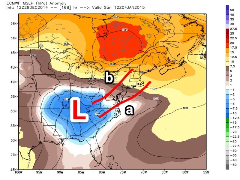
There's 3 tracks this storm can take. There's two shown above that I drew in. The third is a cutter, which I'm beginning to doubt
_________________
_______________________________________________________________________________________________________
CLICK HERE to view NJ Strong Snowstorm Classifications
Frank_Wx- Godzilla Seeker
- Posts : 21305
Reputation : 328
Join date : 2013-01-05
Age : 31
Location : Jersey City, NJ -
Re: Official Long Range Thread 5.0
![]() by NjWeatherGuy Sun Dec 28, 2014 6:16 pm
by NjWeatherGuy Sun Dec 28, 2014 6:16 pm

NjWeatherGuy- Advanced Forecaster
- Posts : 4100
Reputation : 28
Join date : 2013-01-06
Location : Belle Mead, NJ
Re: Official Long Range Thread 5.0
![]() by Frank_Wx Sun Dec 28, 2014 6:26 pm
by Frank_Wx Sun Dec 28, 2014 6:26 pm
_________________
_______________________________________________________________________________________________________
CLICK HERE to view NJ Strong Snowstorm Classifications
Frank_Wx- Godzilla Seeker
- Posts : 21305
Reputation : 328
Join date : 2013-01-05
Age : 31
Location : Jersey City, NJ -
Re: Official Long Range Thread 5.0
![]() by Guest Sun Dec 28, 2014 6:29 pm
by Guest Sun Dec 28, 2014 6:29 pm
Guest- Guest
Re: Official Long Range Thread 5.0
![]() by Guest Sun Dec 28, 2014 7:42 pm
by Guest Sun Dec 28, 2014 7:42 pm
Guest- Guest
Re: Official Long Range Thread 5.0
![]() by amugs Sun Dec 28, 2014 10:12 pm
by amugs Sun Dec 28, 2014 10:12 pm
If you are seeing weaker systems that a by product of the actual low level cold press with the PV getting established near Hudson Bay .
Jan 1 - 10 are colder than just a few days of below normal.
You have to take 2 weeks at a time.
You now have a NEG EPO and it's stays neg for the next 15 days. That matters in a big way. Need the pna to push positive showing nuetral to slight positive. As the models adjust to the cold air in the pattern so may the solutions. The way this does not cut is if the system is weaker ejecting out if the panhandle staying pos tilted and have it sneak E of the MISS. If the confluence is strong it will belly under. If the vortex ends up further N the ridge will pop and this will cut.
Patience.
Syo don't flip on the last phrase.
Lastly, the atmospheric changes that hopefully will be taking shape in our stratosphere will cause model mayhem and wild swings but they are taking place.
_________________
Mugs
AKA:King: Snow Weenie
Self Proclaimed
WINTER 2014-15 : 55.12" +.02 for 6 coatings (avg. 35")
WINTER 2015-16 Total - 29.8" (Avg 35")
WINTER 2016-17 : 39.5" so far

amugs- Advanced Forecaster - Mod

- Posts : 15093
Reputation : 213
Join date : 2013-01-07
Age : 54
Location : Hillsdale,NJ
Re: Official Long Range Thread 5.0
![]() by Guest Sun Dec 28, 2014 10:52 pm
by Guest Sun Dec 28, 2014 10:52 pm
Nice analysis Mugs. Thanks.amugs wrote:Here is the skinny going forward imo
If you are seeing weaker systems that a by product of the actual low level cold press with the PV getting established near Hudson Bay .
Jan 1 - 10 are colder than just a few days of below normal.
You have to take 2 weeks at a time.
You now have a NEG EPO and it's stays neg for the next 15 days. That matters in a big way. Need the pna to push positive showing nuetral to slight positive. As the models adjust to the cold air in the pattern so may the solutions. The way this does not cut is if the system is weaker ejecting out if the panhandle staying pos tilted and have it sneak E of the MISS. If the confluence is strong it will belly under. If the vortex ends up further N the ridge will pop and this will cut.
Patience.
Syo don't flip on the last phrase.
Lastly, the atmospheric changes that hopefully will be taking shape in our stratosphere will cause model mayhem and wild swings but they are taking place.
Guest- Guest
Re: Official Long Range Thread 5.0
![]() by amugs Sun Dec 28, 2014 11:12 pm
by amugs Sun Dec 28, 2014 11:12 pm
WOW

_________________
Mugs
AKA:King: Snow Weenie
Self Proclaimed
WINTER 2014-15 : 55.12" +.02 for 6 coatings (avg. 35")
WINTER 2015-16 Total - 29.8" (Avg 35")
WINTER 2016-17 : 39.5" so far
amugs- Advanced Forecaster - Mod
- Posts : 15093
Reputation : 213
Join date : 2013-01-07
Age : 54
Location : Hillsdale,NJ
Re: Official Long Range Thread 5.0
![]() by Frank_Wx Mon Dec 29, 2014 1:45 am
by Frank_Wx Mon Dec 29, 2014 1:45 am
GFS, CMC, EURO all bring the southern vort east and develop a coastal storm to bring light to moderate accumulations to the area (depending on which model you look at). There is no cutter.
Goodnight.
_________________
_______________________________________________________________________________________________________
CLICK HERE to view NJ Strong Snowstorm Classifications
Frank_Wx- Godzilla Seeker
- Posts : 21305
Reputation : 328
Join date : 2013-01-05
Age : 31
Location : Jersey City, NJ -
Re: Official Long Range Thread 5.0
![]() by SoulSingMG Mon Dec 29, 2014 1:54 am
by SoulSingMG Mon Dec 29, 2014 1:54 am
Frank_Wx wrote:00z model runs update for Jan 5th storm
GFS, CMC, EURO all bring the southern vort east and develop a coastal storm to bring light to moderate accumulations to the area (depending on which model you look at). There is no cutter.
Goodnight.
"There is no cutter. Goodnight." Lol
I love when Frank is frank. And I said closing that last storm thread would light a fire under this Winter. Now let is s____w.

SoulSingMG- Senior Enthusiast

- Posts : 2853
Reputation : 74
Join date : 2013-12-11
Location : Long Island City, NY
Re: Official Long Range Thread 5.0
![]() by docstox12 Mon Dec 29, 2014 5:27 am
by docstox12 Mon Dec 29, 2014 5:27 am

docstox12- Wx Statistician Guru
- Posts : 8502
Reputation : 222
Join date : 2013-01-07
Age : 73
Location : Monroe NY
Re: Official Long Range Thread 5.0
![]() by sroc4 Mon Dec 29, 2014 6:04 am
by sroc4 Mon Dec 29, 2014 6:04 am
amugs wrote:Here is the skinny going forward imo
If you are seeing weaker systems that a by product of the actual low level cold press with the PV getting established near Hudson Bay .
Jan 1 - 10 are colder than just a few days of below normal.
You have to take 2 weeks at a time.
You now have a NEG EPO and it's stays neg for the next 15 days. That matters in a big way. Need the pna to push positive showing nuetral to slight positive. As the models adjust to the cold air in the pattern so may the solutions. The way this does not cut is if the system is weaker ejecting out if the panhandle staying pos tilted and have it sneak E of the MISS. If the confluence is strong it will belly under. If the vortex ends up further N the ridge will pop and this will cut.
Patience.
Syo don't flip on the last phrase.
Lastly, the atmospheric changes that hopefully will be taking shape in our stratosphere will cause model mayhem and wild swings but they are taking place.
Preach on brotha!! Amen!!
https://www.youtube.com/watch?v=gjto02iDNZA
_________________
"In weather and in life, there's no winning and losing; there's only winning and learning."
WINTER 2012/2013 TOTALS 43.65"WINTER 2017/2018 TOTALS 62.85" WINTER 2022/2023 TOTALS 4.9"
WINTER 2013/2014 TOTALS 64.85"WINTER 2018/2019 TOTALS 14.25" WINTER 2023/2024 TOTALS 13.1"
WINTER 2014/2015 TOTALS 71.20"WINTER 2019/2020 TOTALS 6.35"
WINTER 2015/2016 TOTALS 35.00"WINTER 2020/2021 TOTALS 37.75"
WINTER 2016/2017 TOTALS 42.25"WINTER 2021/2022 TOTALS 31.65"

sroc4- Admin
- Posts : 8331
Reputation : 301
Join date : 2013-01-07
Location : Wading River, LI
Re: Official Long Range Thread 5.0
![]() by jmanley32 Mon Dec 29, 2014 7:57 am
by jmanley32 Mon Dec 29, 2014 7:57 am

jmanley32- Senior Enthusiast
- Posts : 20513
Reputation : 108
Join date : 2013-12-12
Age : 42
Location : Yonkers, NY
Re: Official Long Range Thread 5.0
![]() by Frank_Wx Mon Dec 29, 2014 9:22 am
by Frank_Wx Mon Dec 29, 2014 9:22 am
The storm system on thr 4th has trended from a cutter to a southern slider. Why? The polar jet is still very fast, so the short waves are having a tough time ejecting out of it to prompt a phase with the southern vort, the key player in our 4th-5th storm.
So without a phase, this becomes more of a SWFE (Southwest Flow Event) but how far north will determine how much snow we'll see. If the PV is too strong, everthing will be shunned south and we see nothing but cold temps. There also remains the chance this storm tracks to our west and we get rain or rain to snow, but the models haven't shown that yet.
Please refer to the graphic on the previous page to see both possible storm tracks.
_________________
_______________________________________________________________________________________________________
CLICK HERE to view NJ Strong Snowstorm Classifications
Frank_Wx- Godzilla Seeker
- Posts : 21305
Reputation : 328
Join date : 2013-01-05
Age : 31
Location : Jersey City, NJ -
Re: Official Long Range Thread 5.0
![]() by Frank_Wx Mon Dec 29, 2014 11:59 am
by Frank_Wx Mon Dec 29, 2014 11:59 am
_________________
_______________________________________________________________________________________________________
CLICK HERE to view NJ Strong Snowstorm Classifications
Frank_Wx- Godzilla Seeker
- Posts : 21305
Reputation : 328
Join date : 2013-01-05
Age : 31
Location : Jersey City, NJ -
Re: Official Long Range Thread 5.0
![]() by sroc4 Mon Dec 29, 2014 12:12 pm
by sroc4 Mon Dec 29, 2014 12:12 pm
Frank_Wx wrote:GFS at 12z today still insisting on a minor to moderate snowfall for the weekend.
Given the pattern establishing itself as we speak I am concerned with a southern slider soln as we get closer. Strong arctic HP is going to be a theme over the next 10-14days. This one should be an interesting one to follow though.
_________________
"In weather and in life, there's no winning and losing; there's only winning and learning."
WINTER 2012/2013 TOTALS 43.65"WINTER 2017/2018 TOTALS 62.85" WINTER 2022/2023 TOTALS 4.9"
WINTER 2013/2014 TOTALS 64.85"WINTER 2018/2019 TOTALS 14.25" WINTER 2023/2024 TOTALS 13.1"
WINTER 2014/2015 TOTALS 71.20"WINTER 2019/2020 TOTALS 6.35"
WINTER 2015/2016 TOTALS 35.00"WINTER 2020/2021 TOTALS 37.75"
WINTER 2016/2017 TOTALS 42.25"WINTER 2021/2022 TOTALS 31.65"
sroc4- Admin
- Posts : 8331
Reputation : 301
Join date : 2013-01-07
Location : Wading River, LI
Re: Official Long Range Thread 5.0
![]() by Frank_Wx Mon Dec 29, 2014 12:17 pm
by Frank_Wx Mon Dec 29, 2014 12:17 pm
_________________
_______________________________________________________________________________________________________
CLICK HERE to view NJ Strong Snowstorm Classifications
Frank_Wx- Godzilla Seeker
- Posts : 21305
Reputation : 328
Join date : 2013-01-05
Age : 31
Location : Jersey City, NJ -
Page 20 of 40 • 1 ... 11 ... 19, 20, 21 ... 30 ... 40 ![]()
|
|
|