
 Search
Official Long Range Thread 5.0
Page 22 of 40 •  1 ... 12 ... 21, 22, 23 ... 31 ... 40
 ![]()
jmanley32- Senior Enthusiast

- Posts : 20513
Join date : 2013-12-12
Re: Official Long Range Thread 5.0
![]() by Dunnzoo Mon Dec 29, 2014 11:35 pm
by Dunnzoo Mon Dec 29, 2014 11:35 pm
Dunnzoo- Senior Enthusiast - Mod

- Posts : 4887
Join date : 2013-01-11
Re: Official Long Range Thread 5.0
![]() by Frank_Wx Mon Dec 29, 2014 11:41 pm
by Frank_Wx Mon Dec 29, 2014 11:41 pm
Dunnzoo wrote:Navgem has precip as well, CMC is just south and east, channel 7 is watching it, thinking it stays south, but if it comes north we get a mix
I think if it's south we see snow. Obviously west is rain. There will be plenty of cold air around if it tries to come north. Another scenario is a Miller B rain to snow, but models don't show that as of now.
_________________
_______________________________________________________________________________________________________
CLICK HERE to view NJ Strong Snowstorm Classifications

Frank_Wx- Godzilla Seeker

- Posts : 21305
Reputation : 328
Join date : 2013-01-05
Age : 31
Location : Jersey City, NJ -

Re: Official Long Range Thread 5.0
![]() by jmanley32 Tue Dec 30, 2014 12:09 am
by jmanley32 Tue Dec 30, 2014 12:09 am

jmanley32- Senior Enthusiast
- Posts : 20513
Reputation : 108
Join date : 2013-12-12
Age : 42
Location : Yonkers, NY
Re: Official Long Range Thread 5.0
![]() by SoulSingMG Tue Dec 30, 2014 12:23 am
by SoulSingMG Tue Dec 30, 2014 12:23 am
Frank_Wx wrote:Dunnzoo wrote:Navgem has precip as well, CMC is just south and east, channel 7 is watching it, thinking it stays south, but if it comes north we get a mix
I think if it's south we see snow. Obviously west is rain. There will be plenty of cold air around if it tries to come north. Another scenario is a Miller B rain to snow, but models don't show that as of now.
None of this makes any sense to me. The two risks for this storm are:
1) inland runner with rain?
2) southern slider with a snow shower?
????????

SoulSingMG- Senior Enthusiast
- Posts : 2853
Reputation : 74
Join date : 2013-12-11
Location : Long Island City, NY
Re: Official Long Range Thread 5.0
![]() by Frank_Wx Tue Dec 30, 2014 12:27 am
by Frank_Wx Tue Dec 30, 2014 12:27 am
SoulSingMG wrote:Frank_Wx wrote:Dunnzoo wrote:Navgem has precip as well, CMC is just south and east, channel 7 is watching it, thinking it stays south, but if it comes north we get a mix
I think if it's south we see snow. Obviously west is rain. There will be plenty of cold air around if it tries to come north. Another scenario is a Miller B rain to snow, but models don't show that as of now.
None of this makes any sense to me. The two risks for this storm are:
1) inland runner with rain?
2) southern slider with a snow shower?
????????
If the storm tracks south we'll have to see how far north up the coast it can get. If the PV is too strong it will get shunned too far south for impact
_________________
_______________________________________________________________________________________________________
CLICK HERE to view NJ Strong Snowstorm Classifications
Frank_Wx- Godzilla Seeker
- Posts : 21305
Reputation : 328
Join date : 2013-01-05
Age : 31
Location : Jersey City, NJ -
Re: Official Long Range Thread 5.0
![]() by Frank_Wx Tue Dec 30, 2014 1:06 am
by Frank_Wx Tue Dec 30, 2014 1:06 am

That northern stream energy is your reason why the Para is cutting the storm. We either need the southern vort to hang back west a little longer or for there be no polar energy at all so there is no phase.
_________________
_______________________________________________________________________________________________________
CLICK HERE to view NJ Strong Snowstorm Classifications
Frank_Wx- Godzilla Seeker
- Posts : 21305
Reputation : 328
Join date : 2013-01-05
Age : 31
Location : Jersey City, NJ -
Re: Official Long Range Thread 5.0
![]() by Frank_Wx Tue Dec 30, 2014 1:26 am
by Frank_Wx Tue Dec 30, 2014 1:26 am
Frank_Wx wrote:This is how I would characterize January right as of now which is bound to change:
Jan 1st-2nd: Below normal temps.
Jan 3rd: Above normal temps with rain (maybe snow north and west of NYC)
Jan 4th-12th: Below normal temps. with 1-2 snow chances
Jan 14th-19th: Above normal temps.
Jan 20th-30th: Normal to below normal temps
Euro is back to the cutter idea. Unfortunately, this has been the solution I favored (post above made on 28th) since there is a cut-off low in the SW US, but just because the storm may cut does not mean it's the same pattern as before. This is leftover energy from the old pattern.
_________________
_______________________________________________________________________________________________________
CLICK HERE to view NJ Strong Snowstorm Classifications
Frank_Wx- Godzilla Seeker
- Posts : 21305
Reputation : 328
Join date : 2013-01-05
Age : 31
Location : Jersey City, NJ -
Re: Official Long Range Thread 5.0
![]() by Frank_Wx Tue Dec 30, 2014 1:27 am
by Frank_Wx Tue Dec 30, 2014 1:27 am
_________________
_______________________________________________________________________________________________________
CLICK HERE to view NJ Strong Snowstorm Classifications
Frank_Wx- Godzilla Seeker
- Posts : 21305
Reputation : 328
Join date : 2013-01-05
Age : 31
Location : Jersey City, NJ -
Re: Official Long Range Thread 5.0
![]() by algae888 Tue Dec 30, 2014 2:12 am
by algae888 Tue Dec 30, 2014 2:12 am


algae888- Advanced Forecaster

- Posts : 5311
Reputation : 46
Join date : 2013-02-05
Age : 61
Location : mt. vernon, new york
Re: Official Long Range Thread 5.0
![]() by SoulSingMG Tue Dec 30, 2014 3:16 am
by SoulSingMG Tue Dec 30, 2014 3:16 am
algae888 wrote:horrible runs tonight. models are all in agreement with this storm cutting. what's more concerning is it looks like more energy will be digging into sw again after this storm passes and while it gets cold right after storm warm up to follow. mjo now looks like it will be slowing down and hanging in phase 5 instead of moving towards 6,7,and 8. it really looks bad for us into mid month and this new pattern is not any better for us except for some cold shots that move through quickly. with pacific clearly not in our favor, if the atlantic doesn't change we could be in for a long winter.
I wonder if we've ever seen a year since records were kept without any major snowstorm in the area...?
SoulSingMG- Senior Enthusiast
- Posts : 2853
Reputation : 74
Join date : 2013-12-11
Location : Long Island City, NY
Re: Official Long Range Thread 5.0
![]() by sroc4 Tue Dec 30, 2014 8:47 am
by sroc4 Tue Dec 30, 2014 8:47 am
 " />
" />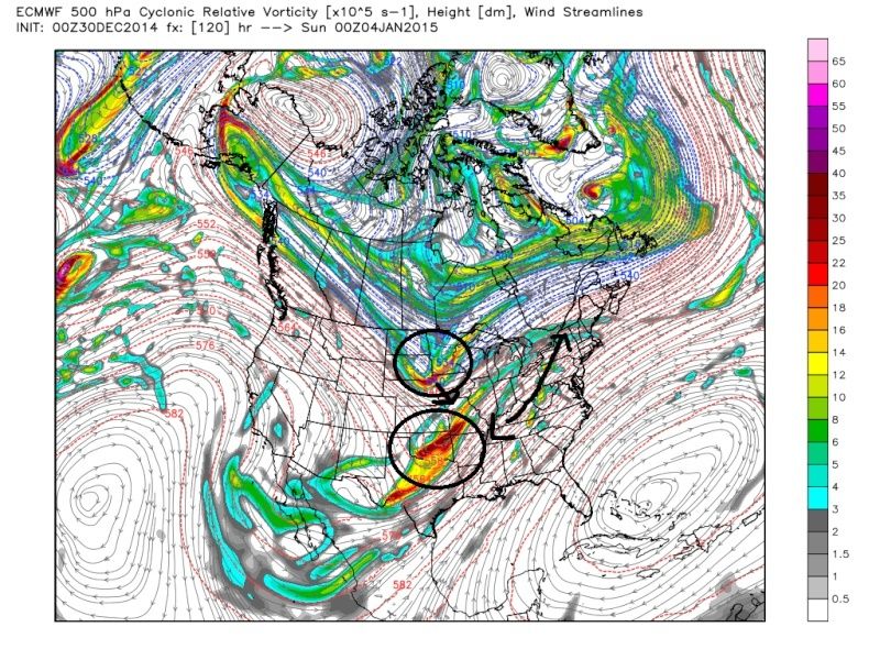 " />
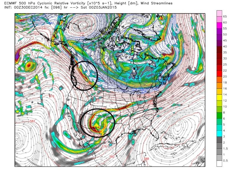
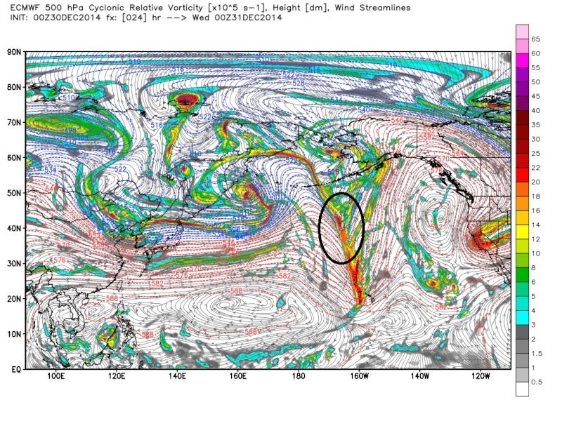
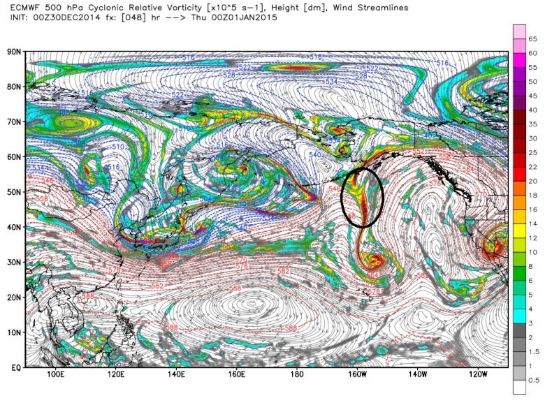
" />HOWEVER:This is the current position of our Northern stream energy
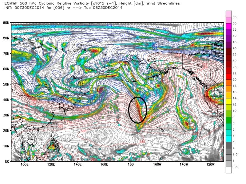 " />
" />This is the Northern stream energy 24, 48, then 72 hrs from now.
 " />
" /> " />
" /> " />
" /> At this point in the blog if you are saying to yourself "WOW the northern stream energy is still currently way the F out in the Pac where there is very little if any data to go into the models, and this energy doesn't even arrive to the Southern shores of Alaska where models will receive better data about this energy for at least 60-72hrs" then you are with me. In addition......
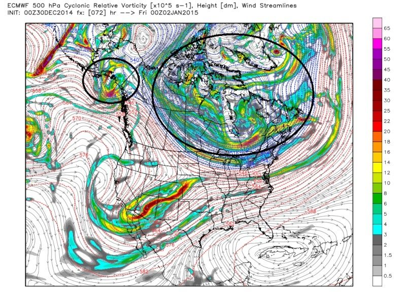 " />
" />If you are thinking to yourself "about 50-75% of the swirling twirly energy that is rotating around what is our PV over the Hudson bay region by hr 72 (3days from now) is also currently way up over the arctic in areas where there is minimal data" then you are with me.
If you are also thinking to yourself, "So far this season the models have an almost 0% track record at nailing down the final soln outside of 3-5days" well then you are also with me. My point here is that the cutter or Apps runner soln may be correct, but don't expect to nail this one down until Thursday the earliest. Stay optimistic and if it doesn't work out then so be it.
_________________
"In weather and in life, there's no winning and losing; there's only winning and learning."
WINTER 2012/2013 TOTALS 43.65"WINTER 2017/2018 TOTALS 62.85" WINTER 2022/2023 TOTALS 4.9"
WINTER 2013/2014 TOTALS 64.85"WINTER 2018/2019 TOTALS 14.25" WINTER 2023/2024 TOTALS 13.1"
WINTER 2014/2015 TOTALS 71.20"WINTER 2019/2020 TOTALS 6.35"
WINTER 2015/2016 TOTALS 35.00"WINTER 2020/2021 TOTALS 37.75"
WINTER 2016/2017 TOTALS 42.25"WINTER 2021/2022 TOTALS 31.65"

sroc4- Admin
- Posts : 8331
Reputation : 301
Join date : 2013-01-07
Location : Wading River, LI
Re: Official Long Range Thread 5.0
![]() by Guest Tue Dec 30, 2014 9:17 am
by Guest Tue Dec 30, 2014 9:17 am
Guest- Guest
Re: Official Long Range Thread 5.0
![]() by sroc4 Tue Dec 30, 2014 9:21 am
by sroc4 Tue Dec 30, 2014 9:21 am
_________________
"In weather and in life, there's no winning and losing; there's only winning and learning."
WINTER 2012/2013 TOTALS 43.65"WINTER 2017/2018 TOTALS 62.85" WINTER 2022/2023 TOTALS 4.9"
WINTER 2013/2014 TOTALS 64.85"WINTER 2018/2019 TOTALS 14.25" WINTER 2023/2024 TOTALS 13.1"
WINTER 2014/2015 TOTALS 71.20"WINTER 2019/2020 TOTALS 6.35"
WINTER 2015/2016 TOTALS 35.00"WINTER 2020/2021 TOTALS 37.75"
WINTER 2016/2017 TOTALS 42.25"WINTER 2021/2022 TOTALS 31.65"
sroc4- Admin
- Posts : 8331
Reputation : 301
Join date : 2013-01-07
Location : Wading River, LI
Re: Official Long Range Thread 5.0
![]() by sroc4 Tue Dec 30, 2014 9:28 am
by sroc4 Tue Dec 30, 2014 9:28 am
syosnow94 wrote:WOW AND I THOUGHT I HAD A GOOD NIGHTS SLEEP!! So storm suppressed today because of arctic cold. Then cold thru Saturday. Then rain because storm cuts. Then back to cold again after storm passes. Stay optimistic...Be patient...I get it. Oh and this MJO thingamajiggy indicator now doesn't look as good anymore for January. Awesome.
Seriously? There is no storm. There is only a virtual storm. It has not occurred yet. We have a bunch of models to look at unfort all of which change attitudes as much as a 16yr old High School girl at the mall with her friends. It is what it is. I wouldn't worry about the MJO BTW.
_________________
"In weather and in life, there's no winning and losing; there's only winning and learning."
WINTER 2012/2013 TOTALS 43.65"WINTER 2017/2018 TOTALS 62.85" WINTER 2022/2023 TOTALS 4.9"
WINTER 2013/2014 TOTALS 64.85"WINTER 2018/2019 TOTALS 14.25" WINTER 2023/2024 TOTALS 13.1"
WINTER 2014/2015 TOTALS 71.20"WINTER 2019/2020 TOTALS 6.35"
WINTER 2015/2016 TOTALS 35.00"WINTER 2020/2021 TOTALS 37.75"
WINTER 2016/2017 TOTALS 42.25"WINTER 2021/2022 TOTALS 31.65"
sroc4- Admin
- Posts : 8331
Reputation : 301
Join date : 2013-01-07
Location : Wading River, LI
Re: Official Long Range Thread 5.0
![]() by Guest Tue Dec 30, 2014 9:29 am
by Guest Tue Dec 30, 2014 9:29 am
sroc4 wrote:I wouldn't worry about the MJO forecast at this point.
I don't even know what it is so I don't worry. I gave up on snow a long time ago. I follow and post now because it's funny how tragically masochistic we are as we all hope when the winter "pattern" has been obvious for weeks now.
Guest- Guest
Re: Official Long Range Thread 5.0
![]() by algae888 Tue Dec 30, 2014 9:37 am
by algae888 Tue Dec 30, 2014 9:37 am
algae888- Advanced Forecaster
- Posts : 5311
Reputation : 46
Join date : 2013-02-05
Age : 61
Location : mt. vernon, new york
Re: Official Long Range Thread 5.0
![]() by sroc4 Tue Dec 30, 2014 9:46 am
by sroc4 Tue Dec 30, 2014 9:46 am
algae888 wrote:Scott I agree with you 100 percent however when was the last time a storm turned in our favor. we have to go back to February 13th of last winter. that's many many storms ago. and about the MJO it's been right so far with the South East Ridge and it's probably a good indicator to let us know when the qbo will be weakening.
IMO it is not a major driver in the pattern. The LR forecast has changed quite a bit recently. Wouldn't be surprised to see it crash into the COD in about 2weeks
_________________
"In weather and in life, there's no winning and losing; there's only winning and learning."
WINTER 2012/2013 TOTALS 43.65"WINTER 2017/2018 TOTALS 62.85" WINTER 2022/2023 TOTALS 4.9"
WINTER 2013/2014 TOTALS 64.85"WINTER 2018/2019 TOTALS 14.25" WINTER 2023/2024 TOTALS 13.1"
WINTER 2014/2015 TOTALS 71.20"WINTER 2019/2020 TOTALS 6.35"
WINTER 2015/2016 TOTALS 35.00"WINTER 2020/2021 TOTALS 37.75"
WINTER 2016/2017 TOTALS 42.25"WINTER 2021/2022 TOTALS 31.65"
sroc4- Admin
- Posts : 8331
Reputation : 301
Join date : 2013-01-07
Location : Wading River, LI
Re: Official Long Range Thread 5.0
![]() by crippo84 Tue Dec 30, 2014 9:51 am
by crippo84 Tue Dec 30, 2014 9:51 am
syosnow94 wrote:sroc4 wrote:I wouldn't worry about the MJO forecast at this point.
I don't even know what it is so I don't worry. I gave up on snow a long time ago. I follow and post now because it's funny how tragically masochistic we are as we all hope when the winter "pattern" has been obvious for weeks now.
You appear to be the only one exhibiting those characteristics...every time you post. It's pretty comical though.
It's funny...if I recall last winter or the winter before, and I could be incorrect here, we had a problem with storms not phasing in time to give us the big hit. It's like we're rolling 2's and 3's on the come-out and 7's on the point.
Frank, Sroc, Mugs, and any others I missed...I'm loving the analysis you guys have been giving. Although it's been disappointing so far this winter, I've learned so much and continue to enjoy following you guys. Keep it coming...I still have plenty of faith in what's in store for the rest of the winter.

crippo84- Posts : 383
Reputation : 20
Join date : 2013-11-07
Age : 40
Location : East Village, NYC
Re: Official Long Range Thread 5.0
![]() by Frank_Wx Tue Dec 30, 2014 10:55 am
by Frank_Wx Tue Dec 30, 2014 10:55 am
Attached Images


_________________
_______________________________________________________________________________________________________
CLICK HERE to view NJ Strong Snowstorm Classifications
Frank_Wx- Godzilla Seeker
- Posts : 21305
Reputation : 328
Join date : 2013-01-05
Age : 31
Location : Jersey City, NJ -
Re: Official Long Range Thread 5.0
![]() by algae888 Tue Dec 30, 2014 12:43 pm
by algae888 Tue Dec 30, 2014 12:43 pm

6z sat

1z sun

6z sat

3z sun
algae888- Advanced Forecaster
- Posts : 5311
Reputation : 46
Join date : 2013-02-05
Age : 61
Location : mt. vernon, new york
Re: Official Long Range Thread 5.0
![]() by algae888 Tue Dec 30, 2014 12:49 pm
by algae888 Tue Dec 30, 2014 12:49 pm
algae888- Advanced Forecaster
- Posts : 5311
Reputation : 46
Join date : 2013-02-05
Age : 61
Location : mt. vernon, new york
Re: Official Long Range Thread 5.0
![]() by Quietace Tue Dec 30, 2014 1:13 pm
by Quietace Tue Dec 30, 2014 1:13 pm
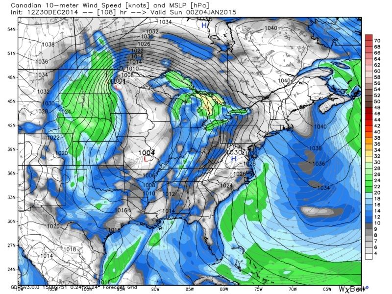
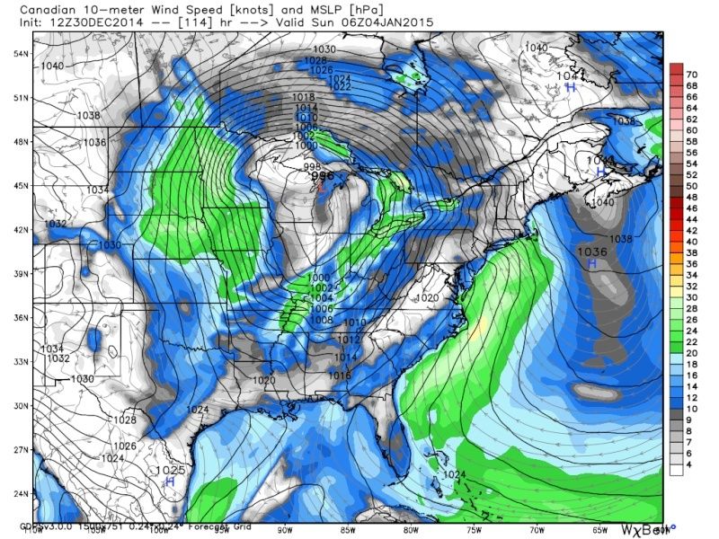
Possible CAD signal IMO. Low level Cold air hangs tough while upper levels torch with low driving into GL. Snow to sleet to ice to rain possible in elevated areas.algae888 wrote:or maybe the strengthening HP is in response to the strengthening LP?
Example is GEM at 108 and 114
2mt temps and related precip, and MSLP and 10m wind.
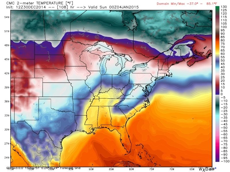
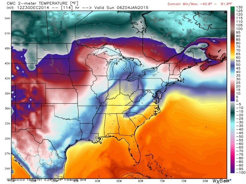
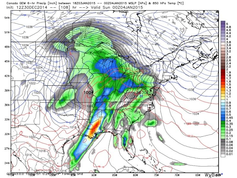
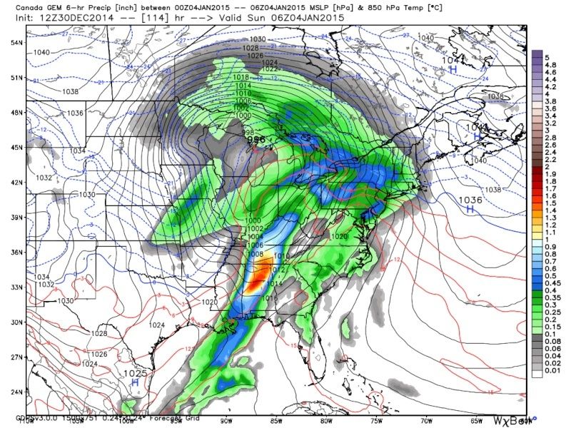
CAD signal is pretty clear on these. 1030 High keeping its nose in while Low cuts. Definitely a possible situation with front end wintery precip before change over in North East PA and HV. Especially if that high can nosed in like shown here.

Quietace- Meteorologist - Mod

- Posts : 3687
Reputation : 33
Join date : 2013-01-07
Age : 27
Location : Point Pleasant, NJ
Re: Official Long Range Thread 5.0
![]() by amugs Tue Dec 30, 2014 1:39 pm
by amugs Tue Dec 30, 2014 1:39 pm
Good catch Al and write up Ace - do not like this set up at all though.
Just a quick note on the atmospheric changes - we need the PV the stay split and not re consolidate after the early jan period and set up camp over Hudson Bay, if it slides west the SE ridge can kick in. Also the perturbation in the atmosphere is impressive and models can not pick up on these changes since they forecast at the 500 mb level from what I have read and these changes can be abrupt once they hit this level filter down from the stratosphere levels.
_________________
Mugs
AKA:King: Snow Weenie
Self Proclaimed
WINTER 2014-15 : 55.12" +.02 for 6 coatings (avg. 35")
WINTER 2015-16 Total - 29.8" (Avg 35")
WINTER 2016-17 : 39.5" so far

amugs- Advanced Forecaster - Mod
- Posts : 15093
Reputation : 213
Join date : 2013-01-07
Age : 54
Location : Hillsdale,NJ
Re: Official Long Range Thread 5.0
![]() by sroc4 Tue Dec 30, 2014 2:10 pm
by sroc4 Tue Dec 30, 2014 2:10 pm
Frank_Wx wrote:This is general for DJF, not Nino. But it's probably close. EPS agrees with the SE ridge flex. A mid month warm up was expected though, that's why I said let's try and capitalize the first 10 days of this month.
I have these images saved in the other thread Frank. We will see what they look like in 7 days from now for the same time frame. My guess is very different, but we will see.
_________________
"In weather and in life, there's no winning and losing; there's only winning and learning."
WINTER 2012/2013 TOTALS 43.65"WINTER 2017/2018 TOTALS 62.85" WINTER 2022/2023 TOTALS 4.9"
WINTER 2013/2014 TOTALS 64.85"WINTER 2018/2019 TOTALS 14.25" WINTER 2023/2024 TOTALS 13.1"
WINTER 2014/2015 TOTALS 71.20"WINTER 2019/2020 TOTALS 6.35"
WINTER 2015/2016 TOTALS 35.00"WINTER 2020/2021 TOTALS 37.75"
WINTER 2016/2017 TOTALS 42.25"WINTER 2021/2022 TOTALS 31.65"
sroc4- Admin
- Posts : 8331
Reputation : 301
Join date : 2013-01-07
Location : Wading River, LI
Re: Official Long Range Thread 5.0
![]() by jmanley32 Tue Dec 30, 2014 2:21 pm
by jmanley32 Tue Dec 30, 2014 2:21 pm
jmanley32- Senior Enthusiast
- Posts : 20513
Reputation : 108
Join date : 2013-12-12
Age : 42
Location : Yonkers, NY
Re: Official Long Range Thread 5.0
![]() by NjWeatherGuy Tue Dec 30, 2014 2:41 pm
by NjWeatherGuy Tue Dec 30, 2014 2:41 pm

NjWeatherGuy- Advanced Forecaster
- Posts : 4100
Reputation : 28
Join date : 2013-01-06
Location : Belle Mead, NJ
Page 22 of 40 • 1 ... 12 ... 21, 22, 23 ... 31 ... 40 ![]()
|
|
|