Official Long Range Thread 5.0
+32
Grselig
essexcountypete
Quietace
carvin1079
chief7
1190ftalt
RJB8525
aiannone
Artechmetals
GreyBeard
Radz
HectorO
crippo84
tigernumba1
NjWeatherGuy
skinsfan1177
Math23x7
WOLVES1
SoulSingMG
LB3147
mako460
nutleyblizzard
jmanley32
Dunnzoo
Snow88
amugs
rb924119
sroc4
algae888
docstox12
CPcantmeasuresnow
Frank_Wx
36 posters
Page 33 of 40
Page 33 of 40 •  1 ... 18 ... 32, 33, 34 ... 36 ... 40
 Re: Official Long Range Thread 5.0
nutleyblizzard wrote:The 6z GFS runs this morning has peaked my interest. The over running event early next week has trended colder, while on the Para for late next week shows a 982mb bomb in the gulf of Maine! That run came very close to clobbering our area. Very interesting week of weather tracking coming up!
Trends in the right direction so the 12z runs today are going to have to stay steady or improve in a good way - just saw this as well - can't wait until the Para takes over completely and will be on par with the euro if not better
6Z GFS Mon-Tues

Euro hr 93

Euro hr 96 by hr 102 it is light

EURO - Fri

A frickin hair away!!!!!

amugs- Advanced Forecaster - Mod

- Posts : 15093
Join date : 2013-01-07
 Re: Official Long Range Thread 5.0
Does it look cold enough for the coast
skinsfan1177- Senior Enthusiast

- Posts : 4485
Join date : 2013-01-07
 Re: Official Long Range Thread 5.0
On that run it looks like p-type may be a issue for coastal areas. FWIW 00z euro has a good dumping down to just a smidge north of NYC, like north Bronx and up and west.

jmanley32- Senior Enthusiast

- Posts : 20517
Reputation : 108
Join date : 2013-12-12
Age : 42
Location : Yonkers, NY
 Re: Official Long Range Thread 5.0
I explained last night we needed positive trends going into the weekend, mainly from the western ridge. We saw that on the 00z runs last night from ALL the models. Very encouraging.
_________________
_______________________________________________________________________________________________________
CLICK HERE to view NJ Strong Snowstorm Classifications
 Re: Official Long Range Thread 5.0
jmanley32 wrote:On that run it looks like p-type may be a issue for coastal areas. FWIW 00z euro has a good dumping down to just a smidge north of NYC, like north Bronx and up and west.
In General the I-95 coastal plain is going to struggle. Plenty of time to see but without blocking to our N and E it has to be perfect. Still way to much time though to call it one way or the other
_________________
"In weather and in life, there's no winning and losing; there's only winning and learning."
WINTER 2012/2013 TOTALS 43.65"WINTER 2017/2018 TOTALS 62.85" WINTER 2022/2023 TOTALS 4.9"
WINTER 2013/2014 TOTALS 64.85"WINTER 2018/2019 TOTALS 14.25" WINTER 2023/2024 TOTALS 13.1"
WINTER 2014/2015 TOTALS 71.20"WINTER 2019/2020 TOTALS 6.35"
WINTER 2015/2016 TOTALS 35.00"WINTER 2020/2021 TOTALS 37.75"
WINTER 2016/2017 TOTALS 42.25"WINTER 2021/2022 TOTALS 31.65"

sroc4- Admin

- Posts : 8331
Reputation : 301
Join date : 2013-01-07
Location : Wading River, LI
 Re: Official Long Range Thread 5.0
Frank_Wx wrote:I explained last night we needed positive trends going into the weekend, mainly from the western ridge. We saw that on the 00z runs last night from ALL the models. Very encouraging.
Without blocking what Frank Said.
_________________
"In weather and in life, there's no winning and losing; there's only winning and learning."
WINTER 2012/2013 TOTALS 43.65"WINTER 2017/2018 TOTALS 62.85" WINTER 2022/2023 TOTALS 4.9"
WINTER 2013/2014 TOTALS 64.85"WINTER 2018/2019 TOTALS 14.25" WINTER 2023/2024 TOTALS 13.1"
WINTER 2014/2015 TOTALS 71.20"WINTER 2019/2020 TOTALS 6.35"
WINTER 2015/2016 TOTALS 35.00"WINTER 2020/2021 TOTALS 37.75"
WINTER 2016/2017 TOTALS 42.25"WINTER 2021/2022 TOTALS 31.65"

sroc4- Admin

- Posts : 8331
Reputation : 301
Join date : 2013-01-07
Location : Wading River, LI
 Re: Official Long Range Thread 5.0
Frank said without blocking it would be hard to get a storm, I do not recall him mentioning p-type issues, I really hope we don't get skunked down here and just north gets it good. Maybe that blocking will come in time? Was there any sign of that last night was that the trend you are talking about that is encouraging or the western ridge or both? Yeah sroc can't discount anything right now, one run in the right direction isn't enough, if we have a few days then it will be even more encouraging as frank stated. U haven't been on much sroc, and ur not coming sat? I recall you mentioning that or am I wrong?

jmanley32- Senior Enthusiast

- Posts : 20517
Reputation : 108
Join date : 2013-12-12
Age : 42
Location : Yonkers, NY
 Re: Official Long Range Thread 5.0
Folks as SROC said coastal plain a toss up peeps - CAD is not modelled well ever so we see the precip and those North of Central NJ take a line NE see snow and the rest struggle with slop - climo possibly here but GFS rolling - Polar vort racing in here for the Mon Tues event let;s see if it gets here to reinforce the cold air and bring us all snow but I am not confident for the coastal sections.
_________________
Mugs
AKA:King: Snow Weenie
Self Proclaimed
WINTER 2014-15 : 55.12" +.02 for 6 coatings (avg. 35")
WINTER 2015-16 Total - 29.8" (Avg 35")
WINTER 2016-17 : 39.5" so far

amugs- Advanced Forecaster - Mod

- Posts : 15093
Reputation : 213
Join date : 2013-01-07
Age : 54
Location : Hillsdale,NJ
 Re: Official Long Range Thread 5.0
Well I'm going to remain confident that's for sure

skinsfan1177- Senior Enthusiast

- Posts : 4485
Reputation : 35
Join date : 2013-01-07
Age : 46
Location : Point Pleasant Boro
 Re: Official Long Range Thread 5.0
Monday night onset i always have trouble withthese frickin times - who can give me a simpel explanation on this Z times - brain freeze right now

Hanging tough - cold air that is sorry ace and skinns

Bringing the good baby!!

Uggh - ICY mess

then back over

Good look and trend on GFS folks

Hanging tough - cold air that is sorry ace and skinns

Bringing the good baby!!

Uggh - ICY mess

then back over

Good look and trend on GFS folks
_________________
Mugs
AKA:King: Snow Weenie
Self Proclaimed
WINTER 2014-15 : 55.12" +.02 for 6 coatings (avg. 35")
WINTER 2015-16 Total - 29.8" (Avg 35")
WINTER 2016-17 : 39.5" so far

amugs- Advanced Forecaster - Mod

- Posts : 15093
Reputation : 213
Join date : 2013-01-07
Age : 54
Location : Hillsdale,NJ
 Re: Official Long Range Thread 5.0
the 2 inches of snow we got here on the coast this morning should help keep temps down lower than forecast and probably help with precip. issues next week.
Guest- Guest
 Re: Official Long Range Thread 5.0
N&W FTW BABY!!!!!!!!!! 3"+


_________________
Mugs
AKA:King: Snow Weenie
Self Proclaimed
WINTER 2014-15 : 55.12" +.02 for 6 coatings (avg. 35")
WINTER 2015-16 Total - 29.8" (Avg 35")
WINTER 2016-17 : 39.5" so far

amugs- Advanced Forecaster - Mod

- Posts : 15093
Reputation : 213
Join date : 2013-01-07
Age : 54
Location : Hillsdale,NJ
 Re: Official Long Range Thread 5.0
COME ON - GOD DAM IT!!! This is going to screw up our late week storm friggin storm crashing into BC
EDIT wrong friggin frames - we r still looking good for late week - nice HP over I-D ----HOOO!

EDIT wrong friggin frames - we r still looking good for late week - nice HP over I-D ----HOOO!

_________________
Mugs
AKA:King: Snow Weenie
Self Proclaimed
WINTER 2014-15 : 55.12" +.02 for 6 coatings (avg. 35")
WINTER 2015-16 Total - 29.8" (Avg 35")
WINTER 2016-17 : 39.5" so far

amugs- Advanced Forecaster - Mod

- Posts : 15093
Reputation : 213
Join date : 2013-01-07
Age : 54
Location : Hillsdale,NJ
 Re: Official Long Range Thread 5.0
I'm not worrying yet a lot of time

skinsfan1177- Senior Enthusiast

- Posts : 4485
Reputation : 35
Join date : 2013-01-07
Age : 46
Location : Point Pleasant Boro
 Re: Official Long Range Thread 5.0
sroc4 wrote:Frank_Wx wrote:I explained last night we needed positive trends going into the weekend, mainly from the western ridge. We saw that on the 00z runs last night from ALL the models. Very encouraging.
Without blocking what Frank Said.
Blocking has been non-existent all winter, but I showed last night in my post that we do appear to have some of it pressing south over northern Greenland. It's not high latitudinal by any means, but it could be enough to help keep the PV stationed over the Hudson and supply our cold air source.
@Jman- I did not even talk about precip types in my post last night. No sense of doing so for a storm over 1 week out.
I will say that the overrunning storm might be trending colder for Monday-Tuesday of next week, GFS has accumulating snowfall. Depending on how things evolve...it could be quite a wintry week.
_________________
_______________________________________________________________________________________________________
CLICK HERE to view NJ Strong Snowstorm Classifications
 Re: Official Long Range Thread 5.0
Frank_Wx wrote:sroc4 wrote:Frank_Wx wrote:I explained last night we needed positive trends going into the weekend, mainly from the western ridge. We saw that on the 00z runs last night from ALL the models. Very encouraging.
Without blocking what Frank Said.
Blocking has been non-existent all winter, but I showed last night in my post that we do appear to have some of it pressing south over northern Greenland. It's not high latitudinal by any means, but it could be enough to help keep the PV stationed over the Hudson and supply our cold air source.
@Jman- I did not even talk about precip types in my post last night. No sense of doing so for a storm over 1 week out.
I will say that the overrunning storm might be trending colder for Monday-Tuesday of next week, GFS has accumulating snowfall. Depending on how things evolve...it could be quite a wintry week.
I hope so Frank. We need a wintry week. Serious question for you I built my kids an ice rink last year with snow and water it was great. They've been begging me to build one this year and I finally have enough snow to do it but....I need to know the temperature forecast for the next few weeks to know whether or not to put in the effort since it takes about 8 hours. I know you can't be exact but an idea on below or above avg. temps would be real helpful. Thanks in advance.
Guest- Guest
 Re: Official Long Range Thread 5.0
jmanley32 wrote:Frank said without blocking it would be hard to get a storm, I do not recall him mentioning p-type issues, I really hope we don't get skunked down here and just north gets it good. Maybe that blocking will come in time? Was there any sign of that last night was that the trend you are talking about that is encouraging or the western ridge or both? Yeah sroc can't discount anything right now, one run in the right direction isn't enough, if we have a few days then it will be even more encouraging as frank stated. U haven't been on much sroc, and ur not coming sat? I recall you mentioning that or am I wrong?
He didnt mention precip types yet because nothing is really set in stone. The set up is this. Not enough phasing we have the issue of the Southern s/w bringing with it warm air that infiltrates the mid layers off the Atlantic because there is just not enough northern energy and therefore colder air involved. Too much phasing or early phasing means much stronger storm, but a west track. Too far west then we have to worry about slop. Without Blocking the southern energy either escapes OTS or we get a partial phase, unless the ridge in the west holds up, which Frank has been discussing, in which case we may get the perfect phase because the N energy may crash into the S energy just right opening up the colder air to the north and a stronger storm. This is less likely for me ATT due to the lack of blocking and the current look to Pacific pattern. A weaker storm that causes mixing issues along the coastal plain or a near miss to the S and E makes more sense to me again only at this time. There is alot of energy in the Pacific that is not well sampled as of yet. Plus we still have to see where the front sets up with the Monday/Tues system. By MOnday 12z or so the we see the final soln revealed for the later week system.
With regards to not being on much I have been crazy busy with work. Ive been on just not posting much. And unfort it doesnt look like I will make it to the gathering which is a shame because I really want to meet all who werent there at the last one.
_________________
"In weather and in life, there's no winning and losing; there's only winning and learning."
WINTER 2012/2013 TOTALS 43.65"WINTER 2017/2018 TOTALS 62.85" WINTER 2022/2023 TOTALS 4.9"
WINTER 2013/2014 TOTALS 64.85"WINTER 2018/2019 TOTALS 14.25" WINTER 2023/2024 TOTALS 13.1"
WINTER 2014/2015 TOTALS 71.20"WINTER 2019/2020 TOTALS 6.35"
WINTER 2015/2016 TOTALS 35.00"WINTER 2020/2021 TOTALS 37.75"
WINTER 2016/2017 TOTALS 42.25"WINTER 2021/2022 TOTALS 31.65"

sroc4- Admin

- Posts : 8331
Reputation : 301
Join date : 2013-01-07
Location : Wading River, LI
 Re: Official Long Range Thread 5.0
syosnow94 wrote:Frank_Wx wrote:sroc4 wrote:Frank_Wx wrote:I explained last night we needed positive trends going into the weekend, mainly from the western ridge. We saw that on the 00z runs last night from ALL the models. Very encouraging.
Without blocking what Frank Said.
Blocking has been non-existent all winter, but I showed last night in my post that we do appear to have some of it pressing south over northern Greenland. It's not high latitudinal by any means, but it could be enough to help keep the PV stationed over the Hudson and supply our cold air source.
@Jman- I did not even talk about precip types in my post last night. No sense of doing so for a storm over 1 week out.
I will say that the overrunning storm might be trending colder for Monday-Tuesday of next week, GFS has accumulating snowfall. Depending on how things evolve...it could be quite a wintry week.
I hope so Frank. We need a wintry week. Serious question for you I built my kids an ice rink last year with snow and water it was great. They've been begging me to build one this year and I finally have enough snow to do it but....I need to know the temperature forecast for the next few weeks to know whether or not to put in the effort since it takes about 8 hours. I know you can't be exact but an idea on below or above avg. temps would be real helpful. Thanks in advance.
It looks pretty average to below average for the foreseeable future. Might be 1 or 2 relaxation days, but looks overall cold
_________________
_______________________________________________________________________________________________________
CLICK HERE to view NJ Strong Snowstorm Classifications
 Re: Official Long Range Thread 5.0
When I spoke ptype issues I meant for Monday not the late week storm, I am aware that's way to far off to make any justified forecasts. I read the last several posts and seems like Monday/Tues may trend colder, which is great, I hope for coastal plain too, but I am marginally on that, sometimes I am just far enough north to get snow by just several miles. Interesting week ahead anyways, sroc sorry we will miss ya bud, your a integral part of the in depth analysis here.

jmanley32- Senior Enthusiast

- Posts : 20517
Reputation : 108
Join date : 2013-12-12
Age : 42
Location : Yonkers, NY
 Re: Official Long Range Thread 5.0
jmanley32 wrote:When I spoke ptype issues I meant for Monday not the late week storm, I am aware that's way to far off to make any justified forecasts. I read the last several posts and seems like Monday/Tues may trend colder, which is great, I hope for coastal plain too, but I am marginally on that, sometimes I am just far enough north to get snow by just several miles. Interesting week ahead anyways, sroc sorry we will miss ya bud, your a integral part of the in depth analysis here.
Thanks man. Appreciate it
_________________
"In weather and in life, there's no winning and losing; there's only winning and learning."
WINTER 2012/2013 TOTALS 43.65"WINTER 2017/2018 TOTALS 62.85" WINTER 2022/2023 TOTALS 4.9"
WINTER 2013/2014 TOTALS 64.85"WINTER 2018/2019 TOTALS 14.25" WINTER 2023/2024 TOTALS 13.1"
WINTER 2014/2015 TOTALS 71.20"WINTER 2019/2020 TOTALS 6.35"
WINTER 2015/2016 TOTALS 35.00"WINTER 2020/2021 TOTALS 37.75"
WINTER 2016/2017 TOTALS 42.25"WINTER 2021/2022 TOTALS 31.65"

sroc4- Admin

- Posts : 8331
Reputation : 301
Join date : 2013-01-07
Location : Wading River, LI
 Re: Official Long Range Thread 5.0
JMAN - Mon/Tues trending colder for N&W looking at 3" + IMO at this this time and euro shows it as well - city 1-2" and fights the slop, LI and coast slop to rain to snow again as it pulls away
Trend not goo don the LR Friday storm between hours 144-168 PAC crushes the +PNA and the storms slides OTS - we have lots of time but that dam PAC Jet is way to fast and crushing things each time we get something going - as Frank said to me in an earlier post - the ingredients are all there but we need that PAC Jet to subside OR a -NAO in the 2 degree level for us to keep these storms from sliding off the coast.
Trend not goo don the LR Friday storm between hours 144-168 PAC crushes the +PNA and the storms slides OTS - we have lots of time but that dam PAC Jet is way to fast and crushing things each time we get something going - as Frank said to me in an earlier post - the ingredients are all there but we need that PAC Jet to subside OR a -NAO in the 2 degree level for us to keep these storms from sliding off the coast.
_________________
Mugs
AKA:King: Snow Weenie
Self Proclaimed
WINTER 2014-15 : 55.12" +.02 for 6 coatings (avg. 35")
WINTER 2015-16 Total - 29.8" (Avg 35")
WINTER 2016-17 : 39.5" so far

amugs- Advanced Forecaster - Mod

- Posts : 15093
Reputation : 213
Join date : 2013-01-07
Age : 54
Location : Hillsdale,NJ
 Re: Official Long Range Thread 5.0
Oh and the warm up - not really much of one - pattern relaxes a bit but cold stays around - mid to upper 30's maybe low 40's but only a couple of days then the pattern looks to reload and we get a pretty good -AO - just need that dam pac jet to slow down or reverse - Frank - read somewhere that Trop Forcing with a Nino will reverse, slow down the PAC jet with equatorial winds running more easterly than westerly and or does this have to do with teh qbo being ungodly negative. Oh crap the dam N Koreans are controlling our weather lets face it 
_________________
Mugs
AKA:King: Snow Weenie
Self Proclaimed
WINTER 2014-15 : 55.12" +.02 for 6 coatings (avg. 35")
WINTER 2015-16 Total - 29.8" (Avg 35")
WINTER 2016-17 : 39.5" so far

amugs- Advanced Forecaster - Mod

- Posts : 15093
Reputation : 213
Join date : 2013-01-07
Age : 54
Location : Hillsdale,NJ
 Re: Official Long Range Thread 5.0
LOL mugs, yeah Euro run for next weekend sucked but its been back and forth, interested to see ensembles. Still way to much time ahead of us. Yeah I hope Monday it trends cold enough to give me more than 1-2, a nice 2-4 I would be happy but I guess I will take what I can get (season total around 8 inches so far lol, pathetic), I just hope not too much freezing rain, too many accidents today with snow, a police officer on saw mill south by my exit mclean ave in Yonkers got hit (not in his car) is at Jacobi with back and neck injuries.

jmanley32- Senior Enthusiast

- Posts : 20517
Reputation : 108
Join date : 2013-12-12
Age : 42
Location : Yonkers, NY
 Re: Official Long Range Thread 5.0
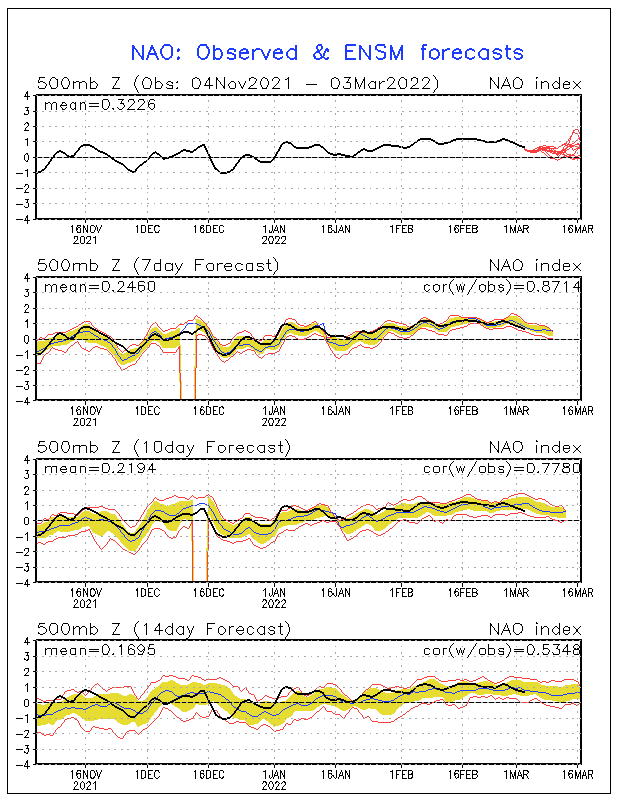
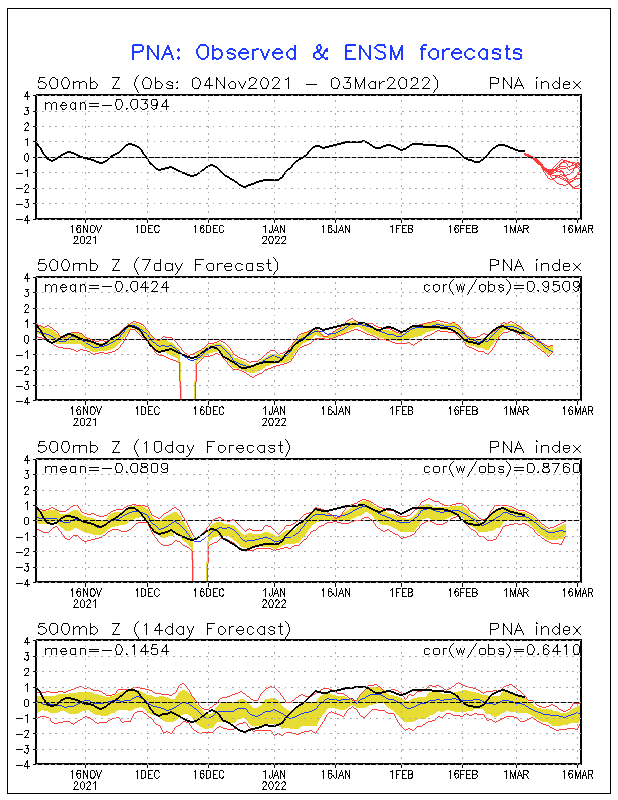
update on some of tele comms.

ao

nao

pna

except for pna everything looks to be headed for a favorable phase. these things change daily what I like the most is the agreement on the mjo all show it heading to phase 7 and 8. interesting to see how it all plays out

ao

nao

pna

except for pna everything looks to be headed for a favorable phase. these things change daily what I like the most is the agreement on the mjo all show it heading to phase 7 and 8. interesting to see how it all plays out

algae888- Advanced Forecaster

- Posts : 5311
Reputation : 46
Join date : 2013-02-05
Age : 61
Location : mt. vernon, new york
 Re: Official Long Range Thread 5.0
I know it's out in lala land but that's a nice look from 18z nam
.

.


algae888- Advanced Forecaster

- Posts : 5311
Reputation : 46
Join date : 2013-02-05
Age : 61
Location : mt. vernon, new york
 Re: Official Long Range Thread 5.0
nws has trended colder with both systems next week. so have probably discounted cmc which looks to amped for the Monday system. still mixing issues for Monday but they now have front and backend snow for most off area with mix and some rain inbetween. one thing to note is that winds will be coming in from the southwest and not off the ocean and they will be light unlike today's so cold air will likely have a hard time being pushed out and should keep precip frozen for a good part off the storm away from immediate coast.

algae888- Advanced Forecaster

- Posts : 5311
Reputation : 46
Join date : 2013-02-05
Age : 61
Location : mt. vernon, new york
 Re: Official Long Range Thread 5.0
nws first call map for momday. looks to be light with about half of precip falling as snow away from imm coast.


algae888- Advanced Forecaster

- Posts : 5311
Reputation : 46
Join date : 2013-02-05
Age : 61
Location : mt. vernon, new york
Page 33 of 40 •  1 ... 18 ... 32, 33, 34 ... 36 ... 40
Page 33 of 40
Permissions in this forum:
You cannot reply to topics in this forum|
|
|

 Home
Home