
 Search
FEB 14th-15th STORM POTENTIAL
Page 12 of 18 •  1 ... 7 ... 11, 12, 13 ... 18
 ![]()
Re: FEB 14th-15th STORM POTENTIAL
![]() by Frank_Wx Thu Feb 12, 2015 1:06 pm
by Frank_Wx Thu Feb 12, 2015 1:06 pm

Frank_Wx- Godzilla Seeker

- Posts : 21305
Join date : 2013-01-05 -

Re: FEB 14th-15th STORM POTENTIAL
![]() by Frank_Wx Thu Feb 12, 2015 1:06 pm
by Frank_Wx Thu Feb 12, 2015 1:06 pm
_________________
_______________________________________________________________________________________________________
CLICK HERE to view NJ Strong Snowstorm Classifications

Frank_Wx- Godzilla Seeker
- Posts : 21305
Reputation : 328
Join date : 2013-01-05
Age : 31
Location : Jersey City, NJ -
Re: FEB 14th-15th STORM POTENTIAL
![]() by rb924119 Thu Feb 12, 2015 1:06 pm
by rb924119 Thu Feb 12, 2015 1:06 pm
Artechmetals wrote:Rb , good or bad ? Don't understand
Bad. The further north the closed mid-level low is, the less of a chance we have of seeing the inverted trough over our area. Think of it this way: When the mid-level low intensifies so much to the point that it "closes off", or becomes it's own CLOSED CIRCULATION, the properties of the atmosphere dictate that the surface low pressure must begin to follow, or for lack of a better phrase, "get sucked underneath" the mid-level closed low. However, because the surface low pressure, and the low pressure circulations between it and at the mid-levels are being raced east-northeastward by incredibly fast winds at these levels, the surface low pressure is being dragged in two separate directions. That is why we are seeing this "inverted trough", because the low pressure at the surface is trying to do two different things at once. It is trying to follow the steering flows at the lower levels, but also draw itself further westward so it can get underneath the mid-level low. Now, if you think about the mid-level low being further north, then the inverted trough, representing the surface low trying to be sucked underneath it, will also be further north because it will try to take the shortest distance between the two locations of the two lows (the surface low and mid-level low). In contrast, the further south that the mid-level low comes, the further south the inverted trough will develop. This trough is very important in the snowfall totals, because whoever gets to be positioned beneath it will see markedly higher totals than anybody else. Does that make sense?
Last edited by rb924119 on Thu Feb 12, 2015 1:08 pm; edited 1 time in total
rb924119- Meteorologist

- Posts : 6889
Reputation : 194
Join date : 2013-02-06
Age : 32
Location : Greentown, Pa
Re: FEB 14th-15th STORM POTENTIAL
![]() by Frank_Wx Thu Feb 12, 2015 1:07 pm
by Frank_Wx Thu Feb 12, 2015 1:07 pm

Still need H5 upper low further south
_________________
_______________________________________________________________________________________________________
CLICK HERE to view NJ Strong Snowstorm Classifications
Frank_Wx- Godzilla Seeker
- Posts : 21305
Reputation : 328
Join date : 2013-01-05
Age : 31
Location : Jersey City, NJ -
Re: FEB 14th-15th STORM POTENTIAL
![]() by Frank_Wx Thu Feb 12, 2015 1:07 pm
by Frank_Wx Thu Feb 12, 2015 1:07 pm

_________________
_______________________________________________________________________________________________________
CLICK HERE to view NJ Strong Snowstorm Classifications
Frank_Wx- Godzilla Seeker
- Posts : 21305
Reputation : 328
Join date : 2013-01-05
Age : 31
Location : Jersey City, NJ -
Re: FEB 14th-15th STORM POTENTIAL
![]() by Frank_Wx Thu Feb 12, 2015 1:08 pm
by Frank_Wx Thu Feb 12, 2015 1:08 pm

_________________
_______________________________________________________________________________________________________
CLICK HERE to view NJ Strong Snowstorm Classifications
Frank_Wx- Godzilla Seeker
- Posts : 21305
Reputation : 328
Join date : 2013-01-05
Age : 31
Location : Jersey City, NJ -
Re: FEB 14th-15th STORM POTENTIAL
![]() by Frank_Wx Thu Feb 12, 2015 1:09 pm
by Frank_Wx Thu Feb 12, 2015 1:09 pm
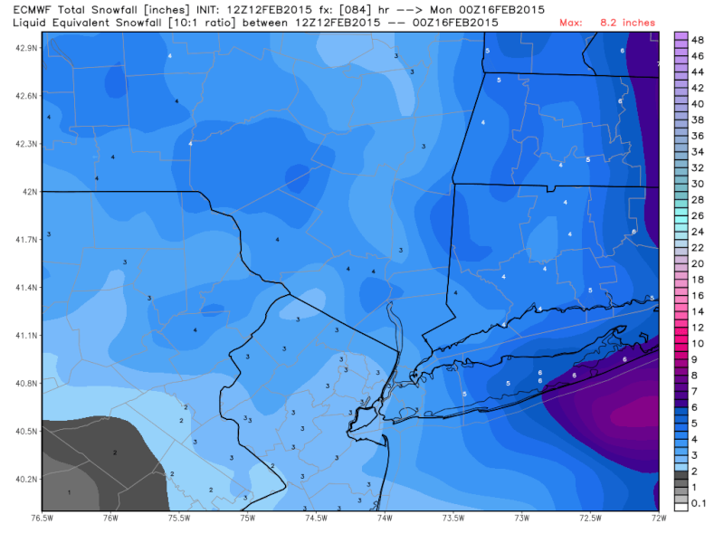
At the surface, this shows more snowfall. So that's a plus!
_________________
_______________________________________________________________________________________________________
CLICK HERE to view NJ Strong Snowstorm Classifications
Frank_Wx- Godzilla Seeker
- Posts : 21305
Reputation : 328
Join date : 2013-01-05
Age : 31
Location : Jersey City, NJ -
Re: FEB 14th-15th STORM POTENTIAL
![]() by Frank_Wx Thu Feb 12, 2015 1:10 pm
by Frank_Wx Thu Feb 12, 2015 1:10 pm
_________________
_______________________________________________________________________________________________________
CLICK HERE to view NJ Strong Snowstorm Classifications
Frank_Wx- Godzilla Seeker
- Posts : 21305
Reputation : 328
Join date : 2013-01-05
Age : 31
Location : Jersey City, NJ -
Re: FEB 14th-15th STORM POTENTIAL
![]() by Frank_Wx Thu Feb 12, 2015 1:12 pm
by Frank_Wx Thu Feb 12, 2015 1:12 pm
_________________
_______________________________________________________________________________________________________
CLICK HERE to view NJ Strong Snowstorm Classifications
Frank_Wx- Godzilla Seeker
- Posts : 21305
Reputation : 328
Join date : 2013-01-05
Age : 31
Location : Jersey City, NJ -
Re: FEB 14th-15th STORM POTENTIAL
![]() by rb924119 Thu Feb 12, 2015 1:13 pm
by rb924119 Thu Feb 12, 2015 1:13 pm
Frank_Wx wrote:Honestly, NYC and points east should be a bit excited about this. The foreign models show at least 6 inches and the GFS keep trending better in that regard. It's NJ that is still in limbo. Unfortunately I do not think PA will get into the heaviest action.
Shocker lmao we've been skipped so many times on these big ones this season. Oh well, that's how it goes ahahaha
rb924119- Meteorologist
- Posts : 6889
Reputation : 194
Join date : 2013-02-06
Age : 32
Location : Greentown, Pa
Re: FEB 14th-15th STORM POTENTIAL
![]() by skinsfan1177 Thu Feb 12, 2015 1:15 pm
by skinsfan1177 Thu Feb 12, 2015 1:15 pm

skinsfan1177- Senior Enthusiast

- Posts : 4485
Reputation : 35
Join date : 2013-01-07
Age : 46
Location : Point Pleasant Boro
Re: FEB 14th-15th STORM POTENTIAL
![]() by Frank_Wx Thu Feb 12, 2015 1:16 pm
by Frank_Wx Thu Feb 12, 2015 1:16 pm
rb924119 wrote:Frank_Wx wrote:Honestly, NYC and points east should be a bit excited about this. The foreign models show at least 6 inches and the GFS keep trending better in that regard. It's NJ that is still in limbo. Unfortunately I do not think PA will get into the heaviest action.
Shocker lmao we've been skipped so many times on these big ones this season. Oh well, that's how it goes ahahaha
You'll get the initial push of upper energy over your area which could produce intense snow squalls depending on the amount of lift present at the time. Who knows, maybe future runs show the norlun extend that far inland but I doubt it in a progressive flow. Tuesday, on the other hand, looks much better for PA and points north and west of NYC
_________________
_______________________________________________________________________________________________________
CLICK HERE to view NJ Strong Snowstorm Classifications
Frank_Wx- Godzilla Seeker
- Posts : 21305
Reputation : 328
Join date : 2013-01-05
Age : 31
Location : Jersey City, NJ -
Re: FEB 14th-15th STORM POTENTIAL
![]() by jimv45 Thu Feb 12, 2015 1:21 pm
by jimv45 Thu Feb 12, 2015 1:21 pm
jimv45- Senior Enthusiast
- Posts : 1168
Reputation : 36
Join date : 2013-09-20
Location : Hopewell jct.
Re: FEB 14th-15th STORM POTENTIAL
![]() by Guest Thu Feb 12, 2015 1:23 pm
by Guest Thu Feb 12, 2015 1:23 pm
1- He's expecting .05" QPF or
2- He's out of touch with reality
WHICH ONE?? or maybe he's right and the models are all wrong!
Guest- Guest
Re: FEB 14th-15th STORM POTENTIAL
![]() by Guest Thu Feb 12, 2015 1:28 pm
by Guest Thu Feb 12, 2015 1:28 pm
Guest- Guest
Re: FEB 14th-15th STORM POTENTIAL
![]() by CPcantmeasuresnow Thu Feb 12, 2015 1:29 pm
by CPcantmeasuresnow Thu Feb 12, 2015 1:29 pm
syosnow94 wrote:So if Bill Evans is forecasting 1" for NYC with ratios that means one of 2 things...
1- He's expecting .05" QPF or
2- He's out of touch with reality
WHICH ONE?? or maybe he's right and the models are all wrong!
You know how it goes with the TV guys Syos, if they have a few days and in this case they have one more at least, they're always going to remain conservative especially when there's still conflicting data like this setup.
Although I'll admit if he said 1-3 that's being reasonable, he went a little to conservative IMO.

CPcantmeasuresnow- Wx Statistician Guru

- Posts : 7274
Reputation : 230
Join date : 2013-01-07
Age : 103
Location : Eastern Orange County, NY
Re: FEB 14th-15th STORM POTENTIAL
![]() by jmanley32 Thu Feb 12, 2015 1:30 pm
by jmanley32 Thu Feb 12, 2015 1:30 pm

jmanley32- Senior Enthusiast
- Posts : 20513
Reputation : 108
Join date : 2013-12-12
Age : 42
Location : Yonkers, NY
Re: FEB 14th-15th STORM POTENTIAL
![]() by Frank_Wx Thu Feb 12, 2015 1:33 pm
by Frank_Wx Thu Feb 12, 2015 1:33 pm
jmanley32 wrote:The euro looks to go south then east on surface, rather than straight across like on 00z, ok so I can get a bit excited, but NJ and NYC are a fine line still. And man oh man those isobars keep getting tighter soon you will not be able to see the spacing. Frank when u said 8-12 do you mean that's what it is showing now or that's what it would be if it got closer? Checking wxbell now.
For NYC and LI, that's now. It's probably 7-9 inches with ratios
_________________
_______________________________________________________________________________________________________
CLICK HERE to view NJ Strong Snowstorm Classifications
Frank_Wx- Godzilla Seeker
- Posts : 21305
Reputation : 328
Join date : 2013-01-05
Age : 31
Location : Jersey City, NJ -
Re: FEB 14th-15th STORM POTENTIAL
![]() by jmanley32 Thu Feb 12, 2015 1:35 pm
by jmanley32 Thu Feb 12, 2015 1:35 pm
Am I close enough to get in that 7-9? It appears my qpf .1 more than city. So appears so plus i'll be a bit colder too, man this is such a touchy storm system anything could happen.
jmanley32- Senior Enthusiast
- Posts : 20513
Reputation : 108
Join date : 2013-12-12
Age : 42
Location : Yonkers, NY
Re: FEB 14th-15th STORM POTENTIAL
![]() by Frank_Wx Thu Feb 12, 2015 1:38 pm
by Frank_Wx Thu Feb 12, 2015 1:38 pm

_________________
_______________________________________________________________________________________________________
CLICK HERE to view NJ Strong Snowstorm Classifications
Frank_Wx- Godzilla Seeker
- Posts : 21305
Reputation : 328
Join date : 2013-01-05
Age : 31
Location : Jersey City, NJ -
Re: FEB 14th-15th STORM POTENTIAL
![]() by jmanley32 Thu Feb 12, 2015 1:39 pm
by jmanley32 Thu Feb 12, 2015 1:39 pm
syosnow94 wrote:If I added up all the colors correctly for me here on the Nassau/Suffolk border using the minimum values, I would get .55 QPF during those 15 hours. Using maximum amounts it would correlate to .85! Not saying this happens, but with ratios of 15:1 or more this could be borderline Godzilla!
syo yes frank did elude to the possibility of a Godzilla, but not quite there buit close, also mentioned that cmc, and I am guessing euro too just due to winds would warrant blizzard warnings for NYC east. Its watch and wait tonight and tomorrow are crutial. I am interested to see how euro ensembles show.
jmanley32- Senior Enthusiast
- Posts : 20513
Reputation : 108
Join date : 2013-12-12
Age : 42
Location : Yonkers, NY
Re: FEB 14th-15th STORM POTENTIAL
![]() by algae888 Thu Feb 12, 2015 1:39 pm
by algae888 Thu Feb 12, 2015 1:39 pm

algae888- Advanced Forecaster

- Posts : 5311
Reputation : 46
Join date : 2013-02-05
Age : 61
Location : mt. vernon, new york
Re: FEB 14th-15th STORM POTENTIAL
![]() by Frank_Wx Thu Feb 12, 2015 1:40 pm
by Frank_Wx Thu Feb 12, 2015 1:40 pm
algae888 wrote:wow 960 mb low with 2 feet of snow and hurricane force winds. for maine. that's pretty much guaranteed.lol very hard to get excited with this storm since the only reliable models to pick up a norlun trough are very short range models like the rap and hrrr. we will not know anything for sure until 12 z saturday. still hoping for the best but a 1 to 3 or 2 to 4 type of event seems likely at the moment
By 00z Friday we should have a pretty solid idea. I will not have a 1st call snow map until Friday afternoon.
_________________
_______________________________________________________________________________________________________
CLICK HERE to view NJ Strong Snowstorm Classifications
Frank_Wx- Godzilla Seeker
- Posts : 21305
Reputation : 328
Join date : 2013-01-05
Age : 31
Location : Jersey City, NJ -
Re: FEB 14th-15th STORM POTENTIAL
![]() by jmanley32 Thu Feb 12, 2015 1:41 pm
by jmanley32 Thu Feb 12, 2015 1:41 pm
Frank_Wx wrote:I guess I will be staying up for the 00z runs tonight
LOL and ur mad about that? Lets hope and have some fun, I have a good feeling we see blizzard warnings and at least 6+ inches with rations from NYC/ immediate suburbs east. If not then so be it but I just have a good feeling, yet also this edgy feeling at the same time.
jmanley32- Senior Enthusiast
- Posts : 20513
Reputation : 108
Join date : 2013-12-12
Age : 42
Location : Yonkers, NY
Re: FEB 14th-15th STORM POTENTIAL
![]() by skinsfan1177 Thu Feb 12, 2015 1:41 pm
by skinsfan1177 Thu Feb 12, 2015 1:41 pm
skinsfan1177- Senior Enthusiast
- Posts : 4485
Reputation : 35
Join date : 2013-01-07
Age : 46
Location : Point Pleasant Boro
Re: FEB 14th-15th STORM POTENTIAL
![]() by jmanley32 Thu Feb 12, 2015 1:43 pm
by jmanley32 Thu Feb 12, 2015 1:43 pm
jmanley32- Senior Enthusiast
- Posts : 20513
Reputation : 108
Join date : 2013-12-12
Age : 42
Location : Yonkers, NY
Page 12 of 18 • 1 ... 7 ... 11, 12, 13 ... 18 ![]()
|
|
|