
 Search
Long Range Thread 9.0
Page 10 of 40 •  1 ... 6 ... 9, 10, 11 ... 25 ... 40
 ![]()
Re: Long Range Thread 9.0
![]() by NjWeatherGuy Wed Dec 02, 2015 4:42 pm
by NjWeatherGuy Wed Dec 02, 2015 4:42 pm
Frank_Wx wrote:NjWeatherGuy wrote:Uh, guys, I think the Canadian just went to a snowstorm on the 8th if im seeing this right, hr 132.
http://meteocentre.com/models/explorateur.php?lang=en&map=na&run=00&mod=gemglb&stn=PNMPR&comp=1&run2=00&mod2=gemglb&stn2=PNMPR&hh2=120&fixhh=1&stn2_type=prog&mode=latest&yyyy=latest&mm=latest&dd=latest&hh=132
No, that's rain. 540 line is in the Great Lakes.
Isnt the 540 the blue line, looks like it gets pulled into the storm from what I see, still could be too warm at the surface but it looks like thats below freezing aloft on last nights run.
NjWeatherGuy- Advanced Forecaster

- Posts : 4100
Join date : 2013-01-06
Re: Long Range Thread 9.0
![]() by amugs Wed Dec 02, 2015 4:48 pm
by amugs Wed Dec 02, 2015 4:48 pm
NjWeatherGuy wrote:Frank_Wx wrote:NjWeatherGuy wrote:Uh, guys, I think the Canadian just went to a snowstorm on the 8th if im seeing this right, hr 132.
http://meteocentre.com/models/explorateur.php?lang=en&map=na&run=00&mod=gemglb&stn=PNMPR&comp=1&run2=00&mod2=gemglb&stn2=PNMPR&hh2=120&fixhh=1&stn2_type=prog&mode=latest&yyyy=latest&mm=latest&dd=latest&hh=132
No, that's rain. 540 line is in the Great Lakes.
Isnt the 540 the blue line, looks like it gets pulled into the storm from what I see, still could be too warm at the surface but it looks like thats below freezing aloft on last nights run.
Tom from teh look sit does start to get pulled from the GL into it but seems to reside in Central PA - funnier things have happened with these beasts but looks to be rain for the coast. Time will tell.
Side not Nick Gregory last night on the 10PM news said there is possibility of a Nor'easter mid week.
amugs- Advanced Forecaster - Mod

- Posts : 15093
Join date : 2013-01-07
Re: Long Range Thread 9.0
![]() by Frank_Wx Wed Dec 02, 2015 8:55 pm
by Frank_Wx Wed Dec 02, 2015 8:55 pm

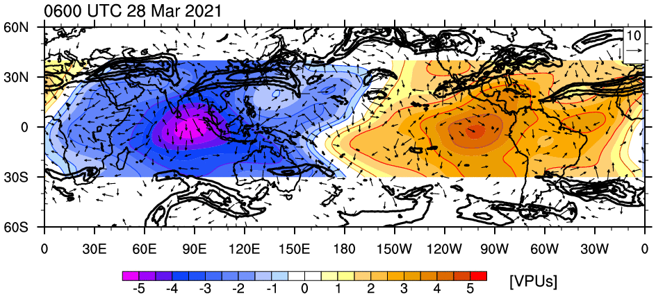
Warming is showing across all of northern Siberia. By this time, 500mb GPHA (geopotential height anomalies) are shown to be positive in west-central Siberia, Europe, and parts of the Arcric. It's worth mentioning that if the amplitude of these ridges strengthen, then that could have greater impact to possibly displacing our Strato Vortex through wave 1 warming.

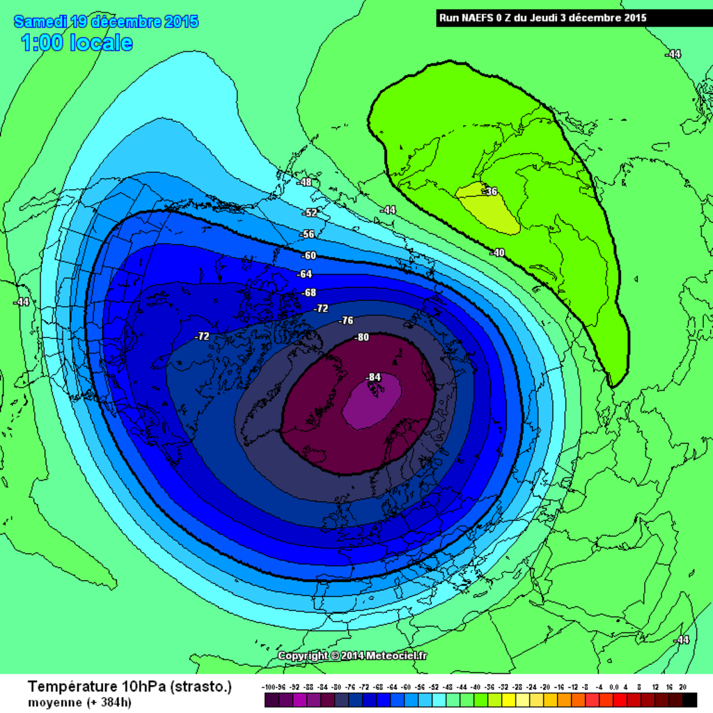
Getting back to upper Strato temps, this time at 384 hours, you can see above normal temps are trying to sneak into the Arctic. This almost resembles a top-down warming event if only it were modeled to be a little stronger.
We want to see this type of warming, preferably stronger, downwell into the mid to lower Stratosphere. Looking at 10 hPa, it doesn't look impressive at this time.
Here's 300 hours -same time frame I posted above.

Thought by 384 hours it's trying to show some life...

Again, these are not fantastic looking maps but it's better than the alternative. Too bad it's modeled way out into the future. How these maps look 7-10 days from today will be interesting to see.
_________________
_______________________________________________________________________________________________________
CLICK HERE to view NJ Strong Snowstorm Classifications

Frank_Wx- Godzilla Seeker

- Posts : 21305
Reputation : 328
Join date : 2013-01-05
Age : 31
Location : Jersey City, NJ -

Re: Long Range Thread 9.0
![]() by Frank_Wx Wed Dec 02, 2015 9:04 pm
by Frank_Wx Wed Dec 02, 2015 9:04 pm

_________________
_______________________________________________________________________________________________________
CLICK HERE to view NJ Strong Snowstorm Classifications
Frank_Wx- Godzilla Seeker
- Posts : 21305
Reputation : 328
Join date : 2013-01-05
Age : 31
Location : Jersey City, NJ -
Re: Long Range Thread 9.0
![]() by Frank_Wx Wed Dec 02, 2015 9:05 pm
by Frank_Wx Wed Dec 02, 2015 9:05 pm
_________________
_______________________________________________________________________________________________________
CLICK HERE to view NJ Strong Snowstorm Classifications
Frank_Wx- Godzilla Seeker
- Posts : 21305
Reputation : 328
Join date : 2013-01-05
Age : 31
Location : Jersey City, NJ -
Re: Long Range Thread 9.0
![]() by Frank_Wx Wed Dec 02, 2015 9:07 pm
by Frank_Wx Wed Dec 02, 2015 9:07 pm
_________________
_______________________________________________________________________________________________________
CLICK HERE to view NJ Strong Snowstorm Classifications
Frank_Wx- Godzilla Seeker
- Posts : 21305
Reputation : 328
Join date : 2013-01-05
Age : 31
Location : Jersey City, NJ -
Re: Long Range Thread 9.0
![]() by algae888 Thu Dec 03, 2015 12:59 pm
by algae888 Thu Dec 03, 2015 12:59 pm

algae888- Advanced Forecaster
- Posts : 5311
Reputation : 46
Join date : 2013-02-05
Age : 61
Location : mt. vernon, new york
Re: Long Range Thread 9.0
![]() by Frank_Wx Thu Dec 03, 2015 1:26 pm
by Frank_Wx Thu Dec 03, 2015 1:26 pm
_________________
_______________________________________________________________________________________________________
CLICK HERE to view NJ Strong Snowstorm Classifications
Frank_Wx- Godzilla Seeker
- Posts : 21305
Reputation : 328
Join date : 2013-01-05
Age : 31
Location : Jersey City, NJ -
Re: Long Range Thread 9.0
![]() by amugs Thu Dec 03, 2015 3:48 pm
by amugs Thu Dec 03, 2015 3:48 pm
Everything seems to be progressing as anticipated thus far. Ozone transport has been increasing via a strengthening BDC, with decreasing temperatures in the tropical stratosphere. The progged precursor pattern should peak around December 10th, leading to a strong spike in WAF anomalies, probably by late December. There are already signs of a wave-1 induced displacement event on the longer term stratospheric forecasts. Tropospheric-stratospheric coupling and energy transfer should be quite strong in the week 2-3 period. We're combatting a robust westerly QBO, but as initially noted in the winter outlook, favorable tropospheric factors should override this influence eventually. My thinking still remains that early-mid January begins the protracted NAM reversal, potentially following an early January stratospheric warming event. The timing is always difficult to predict, but I think the indicators favor the first half of January.
Cliff Notes (those over 40 remember these well!)
What does this mean - we are still on track for a PV displacement or splitting that will allow the AO to go negative for a majority of our winter by early/mid Jan time frame hence the BACK LOADED winter.

_________________
Mugs
AKA:King: Snow Weenie
Self Proclaimed
WINTER 2014-15 : 55.12" +.02 for 6 coatings (avg. 35")
WINTER 2015-16 Total - 29.8" (Avg 35")
WINTER 2016-17 : 39.5" so far

amugs- Advanced Forecaster - Mod
- Posts : 15093
Reputation : 213
Join date : 2013-01-07
Age : 54
Location : Hillsdale,NJ
Re: Long Range Thread 9.0
![]() by amugs Thu Dec 03, 2015 3:54 pm
by amugs Thu Dec 03, 2015 3:54 pm
201510 0.88
201511 0.47
_________________
Mugs
AKA:King: Snow Weenie
Self Proclaimed
WINTER 2014-15 : 55.12" +.02 for 6 coatings (avg. 35")
WINTER 2015-16 Total - 29.8" (Avg 35")
WINTER 2016-17 : 39.5" so far
amugs- Advanced Forecaster - Mod
- Posts : 15093
Reputation : 213
Join date : 2013-01-07
Age : 54
Location : Hillsdale,NJ
Re: Long Range Thread 9.0
![]() by amugs Thu Dec 03, 2015 4:04 pm
by amugs Thu Dec 03, 2015 4:04 pm
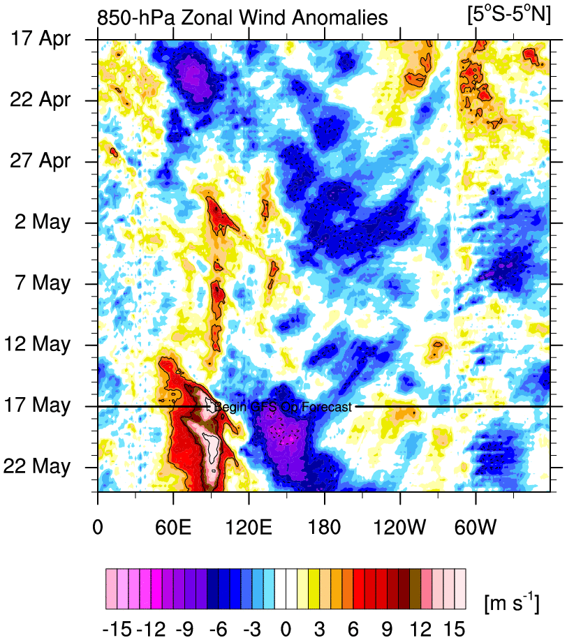
The East Pacific Oscillation (EPO) indicator that I referenced in my blog has been calculated. The H7mb zonal wind across the north Pacific has been calculated at 10.90 m/s, and since anything greater than 7.5 m/s is considered to favor a mean negative mean EPO state throughout the DJFM period, this reading obviously supports a predominately negative EPO as the mean DJFM reading this season, and in fact, only 2004 and 1969 have been more emphatically supportive of a mean DJFM negative EPO than this year. When this indicator has favored a mean DJFM -EPO, it has verified 10/11 times. Obviously, the month of December will come in highly positive, which means that sometime probably in latter January, we will witness a violent reversal as the Gulf of Alaska Low begins to retrograde with great fervor. This reversal should be the theme of the winter.
The behavior of the Atlantic oscillation (AO)/North Atlantic Oscillation (NAO) will likely mimic the behavior of the EPO this season, as there is also information to suggest there is roughy a 71.4% chance of a Sudden Stratospheric Warming (SSW) this season, which acts to disturb the Polar Vortex.
If you are a winter weather aficionado, I suggest that you pull up the shades a take a break from this addictive hobby for about 6 weeks, then abruptly draw the shades and fasten your seat belt for what promises to be a bumpy ride the second half of this season.

DOUBLE BOOOOOOOOOOMMMMMMMMMMMMMM!!!!!!!!!!!!!
_________________
Mugs
AKA:King: Snow Weenie
Self Proclaimed
WINTER 2014-15 : 55.12" +.02 for 6 coatings (avg. 35")
WINTER 2015-16 Total - 29.8" (Avg 35")
WINTER 2016-17 : 39.5" so far
amugs- Advanced Forecaster - Mod
- Posts : 15093
Reputation : 213
Join date : 2013-01-07
Age : 54
Location : Hillsdale,NJ
Re: Long Range Thread 9.0
![]() by NjWeatherGuy Thu Dec 03, 2015 4:13 pm
by NjWeatherGuy Thu Dec 03, 2015 4:13 pm

NjWeatherGuy- Advanced Forecaster
- Posts : 4100
Reputation : 28
Join date : 2013-01-06
Location : Belle Mead, NJ
Re: Long Range Thread 9.0
![]() by NjWeatherGuy Thu Dec 03, 2015 4:16 pm
by NjWeatherGuy Thu Dec 03, 2015 4:16 pm
http://mp1.met.psu.edu/~fxg1/MRF_12z/tr12f264.php
Boy that would be impressive if it verified wouldnt it.
NjWeatherGuy- Advanced Forecaster
- Posts : 4100
Reputation : 28
Join date : 2013-01-06
Location : Belle Mead, NJ
Re: Long Range Thread 9.0
![]() by Frank_Wx Thu Dec 03, 2015 6:11 pm
by Frank_Wx Thu Dec 03, 2015 6:11 pm
1. The SOI continues to crash. It is now down to -42 which suggests the Pacific Jet Stream is anomalously strong. In fact, it's placed a little too far north than where you'll typically find it during El Nino years. I think the SOI + incoming WWB event will cause Nino to continue intensifying over the central regions leading to continued warmth over the central and eastern portions of the U.S. (since the Pac Jet will override the Polar Jet).
Here's a look at the strong Pac jet

Here's a look at the next WWB the GFS is forecasting over the next week. This is on par with what we saw in October!
2. EPS, as well as other guidance, showing very strong Vortex embedded within Pacific trough south of Alaska. In turn, this could lead to positive Mountain Torque conditions to take place which would call for wave forcing to feedback into the Stratosphere.

Obviously during this time our sensible weather will be warmer than normal. But you take some good with the bad and hope around Xmas time we begun to see positive changes take place. Actually, tonight is the first time this season I'm feeling good about our pattern. I think it'll begin to show in the Stratosphere by week 4 of Dec and SSWE to take place sometime in January.
_________________
_______________________________________________________________________________________________________
CLICK HERE to view NJ Strong Snowstorm Classifications
Frank_Wx- Godzilla Seeker
- Posts : 21305
Reputation : 328
Join date : 2013-01-05
Age : 31
Location : Jersey City, NJ -
Re: Long Range Thread 9.0
![]() by algae888 Thu Dec 03, 2015 7:13 pm
by algae888 Thu Dec 03, 2015 7:13 pm
algae888- Advanced Forecaster
- Posts : 5311
Reputation : 46
Join date : 2013-02-05
Age : 61
Location : mt. vernon, new york
Re: Long Range Thread 9.0
![]() by Frank_Wx Thu Dec 03, 2015 7:32 pm
by Frank_Wx Thu Dec 03, 2015 7:32 pm
Day 7: pattern amplification with deep trough and strong low over Alaska and strong ridge in eastern CONUS and Canada.

Day 14: Siberian connection over western North America with continued warmth over the east. -PNA keeps winds over our area coming out of the south.

Day 21 (Xmas time frame) NAO/AO still positive, PNA negative but tighter isobars suggest STJ could be rolling by this time.

Day 30: SW trough beginning to expand east in response to positive heights anomalies getting into EPO/PNA domains.

Not bad.
_________________
_______________________________________________________________________________________________________
CLICK HERE to view NJ Strong Snowstorm Classifications
Frank_Wx- Godzilla Seeker
- Posts : 21305
Reputation : 328
Join date : 2013-01-05
Age : 31
Location : Jersey City, NJ -
Re: Long Range Thread 9.0
![]() by amugs Thu Dec 03, 2015 7:33 pm
by amugs Thu Dec 03, 2015 7:33 pm
@Al, the weeklies look still blah but they along with the op will not pick up on this perturbation of the atmosphere for sometime so we need to be patient.
Those who were neg nanny's and ready to jump ship or off the cliff well you can take a step back now -

Looking better already - Siberian effect ???
_________________
Mugs
AKA:King: Snow Weenie
Self Proclaimed
WINTER 2014-15 : 55.12" +.02 for 6 coatings (avg. 35")
WINTER 2015-16 Total - 29.8" (Avg 35")
WINTER 2016-17 : 39.5" so far
amugs- Advanced Forecaster - Mod
- Posts : 15093
Reputation : 213
Join date : 2013-01-07
Age : 54
Location : Hillsdale,NJ
Re: Long Range Thread 9.0
![]() by Frank_Wx Thu Dec 03, 2015 7:55 pm
by Frank_Wx Thu Dec 03, 2015 7:55 pm

_________________
_______________________________________________________________________________________________________
CLICK HERE to view NJ Strong Snowstorm Classifications
Frank_Wx- Godzilla Seeker
- Posts : 21305
Reputation : 328
Join date : 2013-01-05
Age : 31
Location : Jersey City, NJ -
Re: Long Range Thread 9.0
![]() by Frank_Wx Thu Dec 03, 2015 8:32 pm
by Frank_Wx Thu Dec 03, 2015 8:32 pm
CMS Ens also in agreement same time frame.

Also, improved mean zonal winds 10hPa @ 60 lat according to GEFS. By 384 we're seeing reduced zonal winds

_________________
_______________________________________________________________________________________________________
CLICK HERE to view NJ Strong Snowstorm Classifications
Frank_Wx- Godzilla Seeker
- Posts : 21305
Reputation : 328
Join date : 2013-01-05
Age : 31
Location : Jersey City, NJ -
Re: Long Range Thread 9.0
![]() by CPcantmeasuresnow Thu Dec 03, 2015 10:07 pm
by CPcantmeasuresnow Thu Dec 03, 2015 10:07 pm

CPcantmeasuresnow- Wx Statistician Guru

- Posts : 7274
Reputation : 230
Join date : 2013-01-07
Age : 103
Location : Eastern Orange County, NY
Re: Long Range Thread 9.0
![]() by NjWeatherGuy Thu Dec 03, 2015 11:57 pm
by NjWeatherGuy Thu Dec 03, 2015 11:57 pm
CPcantmeasuresnow wrote:The depth of the analysis on this board is incredible but unfortunately what I'm taking out of it is wake me up in Janauary. I'm finding this incredibly frustrating but the experts here have been warning us about this ridiculously prolonged warmth for fall and early winter for months. I was hoping they'd be wrong but no luck.
I dont know CP, lots of systems before then and one mid month has potential, especially inland around your area, dont hibernate yet. Not the next week storm, a following system.
NjWeatherGuy- Advanced Forecaster
- Posts : 4100
Reputation : 28
Join date : 2013-01-06
Location : Belle Mead, NJ
Re: Long Range Thread 9.0
![]() by Snow88 Fri Dec 04, 2015 12:01 am
by Snow88 Fri Dec 04, 2015 12:01 am

Snow88- Senior Enthusiast

- Posts : 2193
Reputation : 4
Join date : 2013-01-09
Age : 35
Location : Brooklyn, NY
Re: Long Range Thread 9.0
![]() by NjWeatherGuy Fri Dec 04, 2015 3:05 am
by NjWeatherGuy Fri Dec 04, 2015 3:05 am
http://m.accuweather.com/en/weather-news/el-nino-to-deliver-warmth-eastern-central-us-december-january-polar-vortex-locked/53959011
NjWeatherGuy- Advanced Forecaster
- Posts : 4100
Reputation : 28
Join date : 2013-01-06
Location : Belle Mead, NJ
Re: Long Range Thread 9.0
![]() by docstox12 Fri Dec 04, 2015 7:56 am
by docstox12 Fri Dec 04, 2015 7:56 am
NjWeatherGuy wrote:Accuweather expressing some of my concerns about the strong El Nino but they jumped fully on the winter cancel bandwagon which I want to reiterate I am not on right now.
http://m.accuweather.com/en/weather-news/el-nino-to-deliver-warmth-eastern-central-us-december-january-polar-vortex-locked/53959011
Well that Accuweather presentation just re-inforces the back end scenario our resident analysts here have been calling for.What I take from this is if there is snow in Dec and Jan, it will disappear quickly so no snowpack those months.This grim Accuweather prognosis does not concern me as we still have Feb and Mar to make up for lost time.

docstox12- Wx Statistician Guru
- Posts : 8507
Reputation : 222
Join date : 2013-01-07
Age : 73
Location : Monroe NY
Re: Long Range Thread 9.0
![]() by docstox12 Fri Dec 04, 2015 7:57 am
by docstox12 Fri Dec 04, 2015 7:57 am
NjWeatherGuy wrote:CPcantmeasuresnow wrote:The depth of the analysis on this board is incredible but unfortunately what I'm taking out of it is wake me up in Janauary. I'm finding this incredibly frustrating but the experts here have been warning us about this ridiculously prolonged warmth for fall and early winter for months. I was hoping they'd be wrong but no luck.
I dont know CP, lots of systems before then and one mid month has potential, especially inland around your area, dont hibernate yet. Not the next week storm, a following system.
Your analysis fits in to that Accuweather info you posted about snow being possible even in these two "hell nino" Dec and Jan months.
docstox12- Wx Statistician Guru
- Posts : 8507
Reputation : 222
Join date : 2013-01-07
Age : 73
Location : Monroe NY
Re: Long Range Thread 9.0
![]() by NjWeatherGuy Fri Dec 04, 2015 8:25 am
by NjWeatherGuy Fri Dec 04, 2015 8:25 am
https://2img.net/h/oi64.tinypic.com/313kti8.png
NjWeatherGuy- Advanced Forecaster
- Posts : 4100
Reputation : 28
Join date : 2013-01-06
Location : Belle Mead, NJ
Re: Long Range Thread 9.0
![]() by algae888 Fri Dec 04, 2015 8:49 am
by algae888 Fri Dec 04, 2015 8:49 am

the euro ens 500mb mean at day 10 is heading in the right direction for us. the Alaskan vortex is gone. as frank noted earlier, will this be sustained or just transient in nature still to be determined. also all the indicators pna, nao and ao and epo will be around neutral at this time so the 10-15 day period will have to be watched for some wintry weather.
algae888- Advanced Forecaster
- Posts : 5311
Reputation : 46
Join date : 2013-02-05
Age : 61
Location : mt. vernon, new york
Page 10 of 40 • 1 ... 6 ... 9, 10, 11 ... 25 ... 40 ![]()
|
|
|