
 Search
Long Range Thread 9.0
Page 24 of 40 •  1 ... 13 ... 23, 24, 25 ... 32 ... 40
 ![]()
Re: Long Range Thread 9.0
![]() by sroc4 Sat Dec 19, 2015 6:01 pm
by sroc4 Sat Dec 19, 2015 6:01 pm
Frank_Wx wrote:I had a chance to briefly look over long range guidance this afternoon. You're going to have to wait awhile longer if you're looking for winter weather, but the gradual step-down pattern change will begin to take place. The MJO is shown to have an amplified phase 5 pulse due to a potent wave propagating across the Maritime Continent.
Phase 5 MJO composites during El Nino conditions show warmth across the eastern U.S. and Canada. Timing is not great since we're approaching Christmas and New Years. Temp departures from normal should remain between +5 and +10 for the remainder of December. It will be interesting to see how far east into the Pacific this wave will travel. Most forecasts indicate it will die off by the time it reaches the west Pacific - hence the weak phase 6 amplitude on the EURO forecast. If it does, then the forcing we're seeing over the International Dateline could take over and that would lead to ridging developing in the western part of the country. EURO Ens hint at this happening.
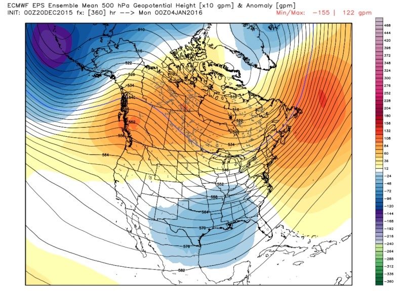
EPS 5-day average height anomaly between Christmas and New Years:
This graphic closely matches the MJO phase 5 composite image I posted earlier. EPS showing the warmth nicely across eastern U.S. / Canada.
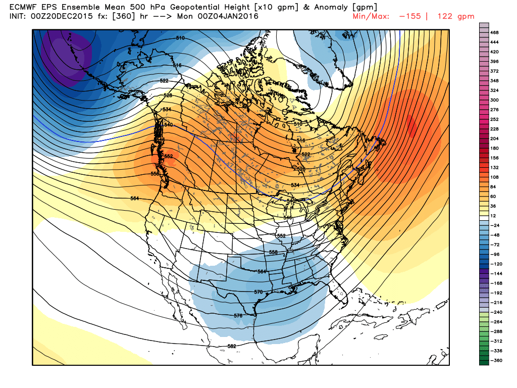
EPS 5-day average height anomaly to begin 2016:
The PNA turned negative to positive and a trough is attempting to settle over the eastern U.S. Considering this is an ensemble mean I actually think it's a pretty strong signal that our pattern is looking to change. There is still a long way to go - and this is the long range anyway - but with Nino reaching its peak and signs of Stratospheric warming occurring during the 1st week of January it will not surprise me to at least start seeing some of the dominoes fall.


Yeah Frank. It's nice to see at least hints of change. I talked a little about this this morning as well.
sroc4- Admin

- Posts : 8331
Join date : 2013-01-07
Re: Long Range Thread 9.0
![]() by Frank_Wx Sat Dec 19, 2015 6:51 pm
by Frank_Wx Sat Dec 19, 2015 6:51 pm
Frank_Wx- Godzilla Seeker
- Posts : 21305
Join date : 2013-01-05 -

Re: Long Range Thread 9.0
![]() by NjWeatherGuy Sat Dec 19, 2015 8:59 pm
by NjWeatherGuy Sat Dec 19, 2015 8:59 pm

NjWeatherGuy- Advanced Forecaster

- Posts : 4100
Reputation : 28
Join date : 2013-01-06
Location : Belle Mead, NJ
Re: Long Range Thread 9.0
![]() by Abba701 Sat Dec 19, 2015 9:03 pm
by Abba701 Sat Dec 19, 2015 9:03 pm
Abba701- Posts : 328
Reputation : 0
Join date : 2013-01-14
Re: Long Range Thread 9.0
![]() by NjWeatherGuy Sat Dec 19, 2015 9:06 pm
by NjWeatherGuy Sat Dec 19, 2015 9:06 pm
Probably around 70Abba701 wrote:What's the highest the temp could be Thursday I'm thinking 70-75?
NjWeatherGuy- Advanced Forecaster
- Posts : 4100
Reputation : 28
Join date : 2013-01-06
Location : Belle Mead, NJ
Re: Long Range Thread 9.0
![]() by Snow88 Sun Dec 20, 2015 1:19 am
by Snow88 Sun Dec 20, 2015 1:19 am
NjWeatherGuy wrote:Just looked at the nino indices after reading what you posted, minor uptick in nearly all regions besides 1,2, frusturating to say the least because while it WILL weaken, the longer it takes to do so, the more time we burn and the more delayed the pattern changes are likely to become. This El Nino has to weaken like ive been harping on for a while and its been frusturatingly slow in doing so, forecasts now have the sharp drop occuring in spring meaning itll still be strong thru winter or upper moderate if it weakens faster by late winter. This is putting us in an uphill battle imo and we're going to need to see some significant changes in January to turn things around. Split flow with progressive trough and positive height anomalies in the east is not gonna cut it to produce a cold and snowy winter.
It's not all about this nino. There are other factors that go into our pattern and things still look on track for a change in mid January.

Snow88- Senior Enthusiast

- Posts : 2193
Reputation : 4
Join date : 2013-01-09
Age : 35
Location : Brooklyn, NY
Re: Long Range Thread 9.0
![]() by sroc4 Sun Dec 20, 2015 7:15 am
by sroc4 Sun Dec 20, 2015 7:15 am
Snow88 wrote:GFS develops ridging in the west and has the pv coming down in the long range. Dare I say the PV splits lol.NjWeatherGuy wrote:Just looked at the nino indices after reading what you posted, minor uptick in nearly all regions besides 1,2, frusturating to say the least because while it WILL weaken, the longer it takes to do so, the more time we burn and the more delayed the pattern changes are likely to become. This El Nino has to weaken like ive been harping on for a while and its been frusturatingly slow in doing so, forecasts now have the sharp drop occuring in spring meaning itll still be strong thru winter or upper moderate if it weakens faster by late winter. This is putting us in an uphill battle imo and we're going to need to see some significant changes in January to turn things around. Split flow with progressive trough and positive height anomalies in the east is not gonna cut it to produce a cold and snowy winter.
It's not all about this nino. There are other factors that go into our pattern and things still look on track for a change in mid January.
Agreed
_________________
"In weather and in life, there's no winning and losing; there's only winning and learning."
WINTER 2012/2013 TOTALS 43.65"WINTER 2017/2018 TOTALS 62.85" WINTER 2022/2023 TOTALS 4.9"
WINTER 2013/2014 TOTALS 64.85"WINTER 2018/2019 TOTALS 14.25" WINTER 2023/2024 TOTALS 13.1"
WINTER 2014/2015 TOTALS 71.20"WINTER 2019/2020 TOTALS 6.35"
WINTER 2015/2016 TOTALS 35.00"WINTER 2020/2021 TOTALS 37.75"
WINTER 2016/2017 TOTALS 42.25"WINTER 2021/2022 TOTALS 31.65"

sroc4- Admin
- Posts : 8331
Reputation : 301
Join date : 2013-01-07
Location : Wading River, LI
Re: Long Range Thread 9.0
![]() by Frank_Wx Sun Dec 20, 2015 8:52 am
by Frank_Wx Sun Dec 20, 2015 8:52 am

Guidance is in agreement a Scandinavian ridge, or block, will develop in the medium range. This has potential to seriously disrupt the Stratospheric PV. Not directly, but it's going to help with the vertical wave energy transfer from the Troposphere into the Stratosphere. The chart Isotherm posted yesterday shows increased +WAF the first week of January. This ridge could be one reason why.

The 00z EPS last night also show a trough developing over the center of the country by the new year. Finally, the deep anomalous troughs are no longer on the western side of the U.S. A ridge will develop over the PNA and/or EPO domains which will drive colder air into the eastern part of the country. The MJO wave is expected to die off next week and become inactive. The 500mb height anomaly map above resembles much more what an El Nino should be - warm in the northern tier and cool in the southern tier of the US with an active STJ.
_________________
_______________________________________________________________________________________________________
CLICK HERE to view NJ Strong Snowstorm Classifications

Frank_Wx- Godzilla Seeker
- Posts : 21305
Reputation : 328
Join date : 2013-01-05
Age : 31
Location : Jersey City, NJ -
Re: Long Range Thread 9.0
![]() by Snow88 Sun Dec 20, 2015 9:32 am
by Snow88 Sun Dec 20, 2015 9:32 am
Snow88- Senior Enthusiast
- Posts : 2193
Reputation : 4
Join date : 2013-01-09
Age : 35
Location : Brooklyn, NY
Re: Long Range Thread 9.0
![]() by sroc4 Sun Dec 20, 2015 10:09 am
by sroc4 Sun Dec 20, 2015 10:09 am
I would like to pause for a minute and acknowledge that Frank truly has taken his gifts to a new level this year with his discussions regarding the stratosphere, and the pattern overall. This is the first year I myself have really been immersing myself into studying the upper levels, and how they affect us earthy beings lower down in the troposphere. It amazes and intrigues me by just how truly complex it all is. I have a pretty good basic understanding, and can follow along when reading in depth discussions from Frank an others, but I still have much to learn, and am def not confident enough yet to blog specifically about it. I am going to continue to let Frank lead us in this area.
Moving on.... Yes there is no doubt a declining El Nino is part of our equation, but the stratosphere, and the stratospheric warming events that have been discussed as of late, really truly will decide if the pattern "flips" to the one that we are all excited for. The type of pattern we can only dream of where we have -NAO/-EPO/-AO/+PNA blocking regimes combined with an amped STJ that would lead to explosive storms in the east and erase all memories of this dreadfully historically warm Novembers and Decembers. Its the changes way up in the stratosphere that will lead to fundamental changes in the 500mb pattern.
Although I cannot yet explain it in a blog(Frank Im sure will in tomorrows Mo Mo) let me assure you all that a pattern change is undoubtedly coming beginning around the first week of Jan., thanks in large part but not limited to the changes that are occurring in the stratosphere over the next 10-14days and then beyond as well. Now remember the phrase step down process. The pattern change I am referring isn't the one I described in the paragraph above, but rather one that begins to eliminate the blow torch in the eastern third of the country, and one that may actually feature closer to normal temp anomalies, AND may even feature the chance for white stuff. We will need to have additional warming events, and stronger warming events in the stratosphere to get to the final pattern. And again I assure you the potential is all there in the modeling for all of it. But talk is cheap right? Right now it is still merely a virtual reality. By mid to late Jan will we know if its truly a reality reality which I still believe is where we are headed.
Here is why the pattern is changing however, as we head into early Jan. Lets revisit the MJO. To remind everyone of where the different phases are refer to this map. Remmeber an MJO in any given phase is gererally defined as a large disorganized area of convection within a given geographical location corresponding the phase of the MJO that propagates east over time.
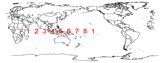 " />
" />Pay particular attention to where phase 4and esp 5 are as there has been strong pulses within these phases for some time now. Here is the latest MJO forecast via the euro:

Notice where it currently is located, right at phase 4 and 5. Notice where it came from, it has slowly propagated from phase 2 to 3 to 4 and now 5. And now look at where its going, towards the center, and possibly back out towards phases 7 and 8.
Now lets look at current observations to give us a visual of the above MJO forecast. In this sat image you can see in the MJO phase 4/5 region there is strong pulses of energy and the arrows show how the polar westerlies are being enhanced by this. As Frank has pointed out in the past El Nino years the MJO is typically a non factor in driving the pattern, but just another reason this El Nino is atypical.
 " />
" />But look at the convection near the dateline in the phase 7/8 locations. Notice how it is starting to release its energy into the northern latitudes. The reason we are not seeing the MJO in phase 7/8 despite clear convection in this location is that the Phase 4/5 energy is the dominant forcing, and the atmosphere is responding as such, trough in west ridging in east. In addition the tight Stratospheric PV centered over the NP has not allowed displacement of the Alaskan vortex(which is not the PV) to drop south of the Aleutians or any blocking to set up over the arctic. When this happens, this meaning the strat warming pushing down on the lower atmosphere, we will finally get some blocking over the pole beginning with the establishment of -EPO and +PNA ridging. As it does so the energy in phase 7/8 which is waiting patiently(which is also due to the forcing established by the el nino status), should begin to interact much more strongly and ultimately become an enhancer to the trough S of the Aleutians. If/Once this occurs the phase lock of the MJO in these locations should/could occur and be more in the way of a pattern enhancer rather than a driver as it seems to be now. Refer way back to Rb's write up involving phase lock of the MJO. This can be found in the weather education threads.
 " />
" />If all goes as planned as the current MJO pulse dies out as it propagates east the stratosphere is also warming, in stages. The result of this allows the Alaskan vortex to finally start to sink south of the Aleutians(blue circle on image above) and interact with the tropical forcing associated with the basin wide nino we have in place at or just east of the dateline.
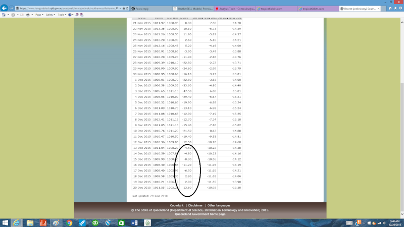
The nino has clearly peaked and is declining. Region 1.2 is beginning to cool rapidly as was expected which should only cont to enhance and focus the tropical forcing centered between about 150W and 180(date line). In addition the waters in the GOA have warmed some as well which will help sustain the trough S of the Aleutians once it gets there
.
 " />
" /> " />
" />The SOI values support the declining El Nino as well.
 " />
" />So as Frank posted above the pattern is clearly changing beginning week 1 of Jan which can be seen in the ensembles.
 " />
" />The final piece to the puzzle comes in the form of a sustained -AO/-NAO which will not occur unless a second stronger SSWE occurs which again as of now looks promising on modeling the first week of Jan the effects of which would be felt a couple weeks down stream. I don't care how much we all hate the warmth right now or how unprecedented it is, Patience is a virtue this winter.
_________________
"In weather and in life, there's no winning and losing; there's only winning and learning."
WINTER 2012/2013 TOTALS 43.65"WINTER 2017/2018 TOTALS 62.85" WINTER 2022/2023 TOTALS 4.9"
WINTER 2013/2014 TOTALS 64.85"WINTER 2018/2019 TOTALS 14.25" WINTER 2023/2024 TOTALS 13.1"
WINTER 2014/2015 TOTALS 71.20"WINTER 2019/2020 TOTALS 6.35"
WINTER 2015/2016 TOTALS 35.00"WINTER 2020/2021 TOTALS 37.75"
WINTER 2016/2017 TOTALS 42.25"WINTER 2021/2022 TOTALS 31.65"
sroc4- Admin
- Posts : 8331
Reputation : 301
Join date : 2013-01-07
Location : Wading River, LI
Re: Long Range Thread 9.0
![]() by NjWeatherGuy Sun Dec 20, 2015 11:46 am
by NjWeatherGuy Sun Dec 20, 2015 11:46 am
http://mag.ncep.noaa.gov/Image.php?fhr=222&image=data%2Fgfs%2F12%2Fgfs_namer_222_850_temp_mslp_precip.gif&model=gfs&area=namer¶m=850_temp_mslp_precip&group=Model+Guidance&preselected_formatted_cycle_date=20151220+12+UTC&imageSize=M&ps=model
Will be watching the evolution of this pattern for sure. Things may get interesting a little earlier than expected if were lucky.
NjWeatherGuy- Advanced Forecaster
- Posts : 4100
Reputation : 28
Join date : 2013-01-06
Location : Belle Mead, NJ
Re: Long Range Thread 9.0
![]() by Dunnzoo Sun Dec 20, 2015 12:10 pm
by Dunnzoo Sun Dec 20, 2015 12:10 pm
_________________
Janet
Snowfall winter of 2023-2024 17.5"
Snowfall winter of 2022-2023 6.0"
Snowfall winter of 2021-2022 17.6" 1" sleet 2/25/22
Snowfall winter of 2020-2021 51.1"
Snowfall winter of 2019-2020 8.5"
Snowfall winter of 2018-2019 25.1"
Snowfall winter of 2017-2018 51.9"
Snowfall winter of 2016-2017 45.6"
Snowfall winter of 2015-2016 29.5"
Snowfall winter of 2014-2015 50.55"
Snowfall winter of 2013-2014 66.5"

Dunnzoo- Senior Enthusiast - Mod

- Posts : 4892
Reputation : 68
Join date : 2013-01-11
Age : 62
Location : Westwood, NJ
Re: Long Range Thread 9.0
![]() by NjWeatherGuy Sun Dec 20, 2015 12:14 pm
by NjWeatherGuy Sun Dec 20, 2015 12:14 pm
http://mag.ncep.noaa.gov/Image.php?fhr=348&image=data%2Fgfs%2F12%2Fgfs_namer_348_850_temp_mslp_precip.gif&model=gfs&area=namer¶m=850_temp_mslp_precip&group=Model+Guidance&preselected_formatted_cycle_date=20151220+12+UTC&imageSize=M&ps=model
NjWeatherGuy- Advanced Forecaster
- Posts : 4100
Reputation : 28
Join date : 2013-01-06
Location : Belle Mead, NJ
Re: Long Range Thread 9.0
![]() by Frank_Wx Sun Dec 20, 2015 1:03 pm
by Frank_Wx Sun Dec 20, 2015 1:03 pm


Get your snowblower ready.
_________________
_______________________________________________________________________________________________________
CLICK HERE to view NJ Strong Snowstorm Classifications
Frank_Wx- Godzilla Seeker
- Posts : 21305
Reputation : 328
Join date : 2013-01-05
Age : 31
Location : Jersey City, NJ -
Re: Long Range Thread 9.0
![]() by snow247 Sun Dec 20, 2015 1:40 pm
by snow247 Sun Dec 20, 2015 1:40 pm
Frank_Wx wrote:So...
Get your snowblower ready.
My snowblower was ready 2 months ago

snow247- Pro Enthusiast

- Posts : 2417
Reputation : 0
Join date : 2014-08-27
Location : Mount Ivy, NY - Elevation 545'
Re: Long Range Thread 9.0
![]() by Math23x7 Sun Dec 20, 2015 2:12 pm
by Math23x7 Sun Dec 20, 2015 2:12 pm
Frank_Wx wrote:So...
Get your snowblower ready.
Of course this happens when I'm set to be in Puerto Rico...
Math23x7- Wx Statistician Guru

- Posts : 2379
Reputation : 68
Join date : 2013-01-08
Re: Long Range Thread 9.0
![]() by Dunnzoo Sun Dec 20, 2015 2:46 pm
by Dunnzoo Sun Dec 20, 2015 2:46 pm
Math23x7 wrote:Frank_Wx wrote:So...
Get your snowblower ready.
Of course this happens when I'm set to be in Puerto Rico...
Well Mikey, I'll be in Florida when the big one comes in February
_________________
Janet
Snowfall winter of 2023-2024 17.5"
Snowfall winter of 2022-2023 6.0"
Snowfall winter of 2021-2022 17.6" 1" sleet 2/25/22
Snowfall winter of 2020-2021 51.1"
Snowfall winter of 2019-2020 8.5"
Snowfall winter of 2018-2019 25.1"
Snowfall winter of 2017-2018 51.9"
Snowfall winter of 2016-2017 45.6"
Snowfall winter of 2015-2016 29.5"
Snowfall winter of 2014-2015 50.55"
Snowfall winter of 2013-2014 66.5"
Dunnzoo- Senior Enthusiast - Mod
- Posts : 4892
Reputation : 68
Join date : 2013-01-11
Age : 62
Location : Westwood, NJ
Re: Long Range Thread 9.0
![]() by docstox12 Sun Dec 20, 2015 2:58 pm
by docstox12 Sun Dec 20, 2015 2:58 pm
You two should have told us earlier you were making these trips it would have started the pattern change two weeks ago!!!

docstox12- Wx Statistician Guru
- Posts : 8507
Reputation : 222
Join date : 2013-01-07
Age : 73
Location : Monroe NY
Re: Long Range Thread 9.0
![]() by Math23x7 Sun Dec 20, 2015 3:16 pm
by Math23x7 Sun Dec 20, 2015 3:16 pm
docstox12 wrote:Janet, I'll save a couple of snowballs in my freezer for you and Mike for when you guys get back from your trips.
You two should have told us earlier you were making these trips it would have started the pattern change two weeks ago!!!
I mentioned about a month ago I was set to be in PR two days after Christmas.
Math23x7- Wx Statistician Guru
- Posts : 2379
Reputation : 68
Join date : 2013-01-08
Re: Long Range Thread 9.0
![]() by NjWeatherGuy Sun Dec 20, 2015 3:16 pm
by NjWeatherGuy Sun Dec 20, 2015 3:16 pm
http://mag.ncep.noaa.gov/Image.php?fhr=360&image=data%2Fgfs%2F00%2Fgfs_namer_360_500_vort_ht.gif&model=gfs&area=namer¶m=500_vort_ht&group=Model+Guidance&preselected_formatted_cycle_date=20151205+00+UTC&imageSize=M&ps=model
500mb 1st week Jan
NjWeatherGuy- Advanced Forecaster
- Posts : 4100
Reputation : 28
Join date : 2013-01-06
Location : Belle Mead, NJ
Re: Long Range Thread 9.0
![]() by NjWeatherGuy Sun Dec 20, 2015 5:31 pm
by NjWeatherGuy Sun Dec 20, 2015 5:31 pm
http://www.ospo.noaa.gov/data/sst/anomaly/anomwnc.gif
This will increase any ocean air influence with any storms and eastern fetch will be a problem until we get significant cooling in this region. One positive is that if we can get some coastal Miller As to track up the coast they may really bomb out over that warm water and enhance moisture and if we have a cold airmass and high pressure over land we coul get a good setup to come together in the coming weeks.
NjWeatherGuy- Advanced Forecaster
- Posts : 4100
Reputation : 28
Join date : 2013-01-06
Location : Belle Mead, NJ
Re: Long Range Thread 9.0
![]() by NjWeatherGuy Sun Dec 20, 2015 5:37 pm
by NjWeatherGuy Sun Dec 20, 2015 5:37 pm
http://www.tropicaltidbits.com/analysis/cdas-sflux_ssta_atl_1.png
NjWeatherGuy- Advanced Forecaster
- Posts : 4100
Reputation : 28
Join date : 2013-01-06
Location : Belle Mead, NJ
Re: Long Range Thread 9.0
![]() by sroc4 Sun Dec 20, 2015 8:11 pm
by sroc4 Sun Dec 20, 2015 8:11 pm
Frank_Wx wrote:So...
Get your snowblower ready.
Well ain't that something? Giggidy!
_________________
"In weather and in life, there's no winning and losing; there's only winning and learning."
WINTER 2012/2013 TOTALS 43.65"WINTER 2017/2018 TOTALS 62.85" WINTER 2022/2023 TOTALS 4.9"
WINTER 2013/2014 TOTALS 64.85"WINTER 2018/2019 TOTALS 14.25" WINTER 2023/2024 TOTALS 13.1"
WINTER 2014/2015 TOTALS 71.20"WINTER 2019/2020 TOTALS 6.35"
WINTER 2015/2016 TOTALS 35.00"WINTER 2020/2021 TOTALS 37.75"
WINTER 2016/2017 TOTALS 42.25"WINTER 2021/2022 TOTALS 31.65"
sroc4- Admin
- Posts : 8331
Reputation : 301
Join date : 2013-01-07
Location : Wading River, LI
Re: Long Range Thread 9.0
![]() by amugs Sun Dec 20, 2015 10:28 pm
by amugs Sun Dec 20, 2015 10:28 pm
Okay, EPS ens mean showing what I have been harping on since August ad nasuem for crying all night - Trop convection at the dateline will help pull the AL low Sw and then allow the heights the rise in BC (+PNA) plus a -EPO and thus causing a trough in the SE. That is being shown and the models are finally picking up on this. Great evolution happening. Not saying it is going to be frigid but nack to normal and we see white gold chances upcoming.
_________________
Mugs
AKA:King: Snow Weenie
Self Proclaimed
WINTER 2014-15 : 55.12" +.02 for 6 coatings (avg. 35")
WINTER 2015-16 Total - 29.8" (Avg 35")
WINTER 2016-17 : 39.5" so far

amugs- Advanced Forecaster - Mod
- Posts : 15093
Reputation : 213
Join date : 2013-01-07
Age : 54
Location : Hillsdale,NJ
Re: Long Range Thread 9.0
![]() by CPcantmeasuresnow Sun Dec 20, 2015 10:33 pm
by CPcantmeasuresnow Sun Dec 20, 2015 10:33 pm
amugs wrote:Wow peeps crazy weekend but just read up on posts and holy snikes ol' man winter is looking to bring us some goods. Love the dirty talk there Frank and let's hope we see this come to fruition. Read Isotherms posts in the other thread and wow is that very positive and encouraging. SROC great post BTW and sorry just realized posted the same map as you above - same page paisan!!
Okay, EPS ens mean showing what I have been harping on since August ad nasuem for crying all night - Trop convection at the dateline will help pull the AL low Sw and then allow the heights the rise in BC (+PNA) plus a -EPO and thus causing a trough in the SE. That is being shown and the models are finally picking up on this. Great evolution happening. Not saying it is going to be frigid but nack to normal and we see white gold chances upcoming.
Normal is all most of us are asking for and would be very happy with, this constant 20 degrees above normal is draining on the snow weenie psyche.

CPcantmeasuresnow- Wx Statistician Guru
- Posts : 7274
Reputation : 230
Join date : 2013-01-07
Age : 103
Location : Eastern Orange County, NY
Re: Long Range Thread 9.0
![]() by amugs Sun Dec 20, 2015 10:45 pm
by amugs Sun Dec 20, 2015 10:45 pm
Have faith my man I may not wear
ITS COMING!!!!
http://www.weather.gov/media/okx/Climate/CentralPark/monthlyseasonalsnowfall.pdf
_________________
Mugs
AKA:King: Snow Weenie
Self Proclaimed
WINTER 2014-15 : 55.12" +.02 for 6 coatings (avg. 35")
WINTER 2015-16 Total - 29.8" (Avg 35")
WINTER 2016-17 : 39.5" so far
amugs- Advanced Forecaster - Mod
- Posts : 15093
Reputation : 213
Join date : 2013-01-07
Age : 54
Location : Hillsdale,NJ
Re: Long Range Thread 9.0
![]() by Abba701 Mon Dec 21, 2015 12:00 am
by Abba701 Mon Dec 21, 2015 12:00 am
Abba701- Posts : 328
Reputation : 0
Join date : 2013-01-14
Page 24 of 40 • 1 ... 13 ... 23, 24, 25 ... 32 ... 40 ![]()
|
|
|