
 Search
Long Range Thread 9.0
Page 32 of 40 •  1 ... 17 ... 31, 32, 33 ... 36 ... 40
 ![]()
Re: Long Range Thread 9.0
![]() by Snow88 Sun Dec 27, 2015 10:04 am
by Snow88 Sun Dec 27, 2015 10:04 am
Snow88- Senior Enthusiast

- Posts : 2193
Join date : 2013-01-09
Re: Long Range Thread 9.0
![]() by amugs Sun Dec 27, 2015 10:17 am
by amugs Sun Dec 27, 2015 10:17 am
syosnow94 wrote:What ever happened to the threat during the time frame of January 1st to 3rd that sroc4 was interested in?
It is there but off the coast right now - lots of time - bring the cold air and pattern first the we hammer out these details. A STJ and percolation in teh atmosphere things can change on a dime in the upcoming set up storm wise.
GFS

amugs- Advanced Forecaster - Mod

- Posts : 15093
Join date : 2013-01-07
Re: Long Range Thread 9.0
![]() by chief7 Sun Dec 27, 2015 6:21 pm
by chief7 Sun Dec 27, 2015 6:21 pm
chief7- Posts : 132
Reputation : 0
Join date : 2013-11-10
Location : Langhorne pa
Re: Long Range Thread 9.0
![]() by amugs Sun Dec 27, 2015 6:24 pm
by amugs Sun Dec 27, 2015 6:24 pm
https://www.nymetroweather.com/2015/12/27/long-range-winter-is-coming-january-pattern-change-details/
An excellent analysis in depth and on the mark to everything Frank, Sroc and meself have been harping on. Change is coming to the area nearest you!!
This an evolution and when we lock in this pattern come mid Jan we will have many opportunities for good to great storms through Feb into early March.
Heck last winter we did not a good storm until late Jan, everything before this was a clipper or front of .5 to 1.5,2 inches. 1977-78 same happened
_________________
Mugs
AKA:King: Snow Weenie
Self Proclaimed
WINTER 2014-15 : 55.12" +.02 for 6 coatings (avg. 35")
WINTER 2015-16 Total - 29.8" (Avg 35")
WINTER 2016-17 : 39.5" so far

amugs- Advanced Forecaster - Mod
- Posts : 15093
Reputation : 213
Join date : 2013-01-07
Age : 54
Location : Hillsdale,NJ
Re: Long Range Thread 9.0
![]() by amugs Sun Dec 27, 2015 6:24 pm
by amugs Sun Dec 27, 2015 6:24 pm
_________________
Mugs
AKA:King: Snow Weenie
Self Proclaimed
WINTER 2014-15 : 55.12" +.02 for 6 coatings (avg. 35")
WINTER 2015-16 Total - 29.8" (Avg 35")
WINTER 2016-17 : 39.5" so far
amugs- Advanced Forecaster - Mod
- Posts : 15093
Reputation : 213
Join date : 2013-01-07
Age : 54
Location : Hillsdale,NJ
Re: Long Range Thread 9.0
![]() by amugs Sun Dec 27, 2015 6:46 pm
by amugs Sun Dec 27, 2015 6:46 pm
Models will be playing catch up and will - EPS ENS showing ugly cold in the east come mid Jan timeframe - you watch peeps we turn and Frank and Sroc alluded to the snap back in the atmosphere and it is going to snap.
_________________
Mugs
AKA:King: Snow Weenie
Self Proclaimed
WINTER 2014-15 : 55.12" +.02 for 6 coatings (avg. 35")
WINTER 2015-16 Total - 29.8" (Avg 35")
WINTER 2016-17 : 39.5" so far
amugs- Advanced Forecaster - Mod
- Posts : 15093
Reputation : 213
Join date : 2013-01-07
Age : 54
Location : Hillsdale,NJ
Re: Long Range Thread 9.0
![]() by chief7 Sun Dec 27, 2015 6:51 pm
by chief7 Sun Dec 27, 2015 6:51 pm
chief7- Posts : 132
Reputation : 0
Join date : 2013-11-10
Location : Langhorne pa
Re: Long Range Thread 9.0
![]() by CPcantmeasuresnow Sun Dec 27, 2015 6:58 pm
by CPcantmeasuresnow Sun Dec 27, 2015 6:58 pm
amugs wrote:Great write up by Miguel from NY Metro Weather where Earthlight is the head honcho:
https://www.nymetroweather.com/2015/12/27/long-range-winter-is-coming-january-pattern-change-details/
An excellent analysis in depth and on the mark to everything Frank, Sroc and meself have been harping on. Change is coming to the area nearest you!!
This an evolution and when we lock in this pattern come mid Jan we will have many opportunities for good to great storms through Feb into early March.
Heck last winter we did not a good storm until late Jan, everything before this was a clipper or front of .5 to 1.5,2 inches. 1977-78 same happened
But you also have to consider that a December that is by far the warmest in history, and has been as warm as the average April, never happened in those years either. I'm certainly no expert, I'm barely a novice, but that has to weigh into the equation somewhere here.

CPcantmeasuresnow- Wx Statistician Guru

- Posts : 7274
Reputation : 230
Join date : 2013-01-07
Age : 103
Location : Eastern Orange County, NY
Re: Long Range Thread 9.0
![]() by skinsfan1177 Sun Dec 27, 2015 7:00 pm
by skinsfan1177 Sun Dec 27, 2015 7:00 pm

skinsfan1177- Senior Enthusiast
- Posts : 4485
Reputation : 35
Join date : 2013-01-07
Age : 46
Location : Point Pleasant Boro
Re: Long Range Thread 9.0
![]() by Dunnzoo Sun Dec 27, 2015 7:08 pm
by Dunnzoo Sun Dec 27, 2015 7:08 pm
CPcantmeasuresnow wrote:amugs wrote:Great write up by Miguel from NY Metro Weather where Earthlight is the head honcho:
https://www.nymetroweather.com/2015/12/27/long-range-winter-is-coming-january-pattern-change-details/
An excellent analysis in depth and on the mark to everything Frank, Sroc and meself have been harping on. Change is coming to the area nearest you!!
This an evolution and when we lock in this pattern come mid Jan we will have many opportunities for good to great storms through Feb into early March.
Heck last winter we did not a good storm until late Jan, everything before this was a clipper or front of .5 to 1.5,2 inches. 1977-78 same happened
I would imagine since the Atlantic waters are still warm it will bring warm air into the mix when we get a coastal...
But you also have to consider that a December that is by far the warmest in history, and has been as warm as the average April, never happened in those years either. I'm certainly no expert, I'm barely a novice, but that has to weigh into the equation somewhere here.
_________________
Janet
Snowfall winter of 2023-2024 17.5"
Snowfall winter of 2022-2023 6.0"
Snowfall winter of 2021-2022 17.6" 1" sleet 2/25/22
Snowfall winter of 2020-2021 51.1"
Snowfall winter of 2019-2020 8.5"
Snowfall winter of 2018-2019 25.1"
Snowfall winter of 2017-2018 51.9"
Snowfall winter of 2016-2017 45.6"
Snowfall winter of 2015-2016 29.5"
Snowfall winter of 2014-2015 50.55"
Snowfall winter of 2013-2014 66.5"

Dunnzoo- Senior Enthusiast - Mod
- Posts : 4891
Reputation : 68
Join date : 2013-01-11
Age : 62
Location : Westwood, NJ
Re: Long Range Thread 9.0
![]() by amugs Sun Dec 27, 2015 9:12 pm
by amugs Sun Dec 27, 2015 9:12 pm
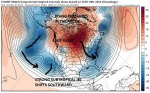
Reading some of the bad analysis over the past few weeks, particularly in regards to the stratosphere. It seems many have this "denial" of the ongoing changes, and simply don't want to admit that the pattern is in fact changing. I have, however, noticed many more people coming around to our ideas now that the guidance is essentially undeniable in the D7+ range. It feels good to see these changes evolve as anticipated, in accordance with the research/preparation done beforehand.
Examining the NAO / AO progression for 1958, it appears the AO will be following a similar time scale, and we actually look to be ahead of the NAO in 1958. January 16th-17th was the NAO flip in 1958. It may occur by January 10th this month.
There's a possibility that we enter a pattern which is more conducive than anything we've seen since 2010-11 insofar as larger threats. The real negative NAO signal, almost necessary for the bigger events, has been virtually absent over the past several years. I think the pattern will turn quite active w/ the STJ and high latitude blocking post January 10th. I'm not terribly enthused with snow chances in the first week to 10 days of January, but as we've seen in the past, often times the cold comes first, then the snow. December 2010 took almost the entire month to produce a significant snowfall. However, I don't think it'll take as long here due to the enhancement of the sub tropical jet by the second week of January.
Now that the CFSV2 has officially flipped, there's not much remaining for the wall to wall furnace forecasters to hold onto.
BOOOOOOMMMMMM
_________________
Mugs
AKA:King: Snow Weenie
Self Proclaimed
WINTER 2014-15 : 55.12" +.02 for 6 coatings (avg. 35")
WINTER 2015-16 Total - 29.8" (Avg 35")
WINTER 2016-17 : 39.5" so far
amugs- Advanced Forecaster - Mod
- Posts : 15093
Reputation : 213
Join date : 2013-01-07
Age : 54
Location : Hillsdale,NJ
Re: Long Range Thread 9.0
![]() by amugs Sun Dec 27, 2015 9:39 pm
by amugs Sun Dec 27, 2015 9:39 pm
_________________
Mugs
AKA:King: Snow Weenie
Self Proclaimed
WINTER 2014-15 : 55.12" +.02 for 6 coatings (avg. 35")
WINTER 2015-16 Total - 29.8" (Avg 35")
WINTER 2016-17 : 39.5" so far
amugs- Advanced Forecaster - Mod
- Posts : 15093
Reputation : 213
Join date : 2013-01-07
Age : 54
Location : Hillsdale,NJ
Re: Long Range Thread 9.0
![]() by sroc4 Mon Dec 28, 2015 6:46 am
by sroc4 Mon Dec 28, 2015 6:46 am
 " />
" />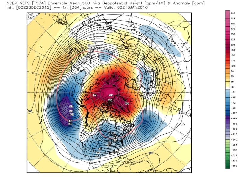 " />
" />_________________
"In weather and in life, there's no winning and losing; there's only winning and learning."
WINTER 2012/2013 TOTALS 43.65"WINTER 2017/2018 TOTALS 62.85" WINTER 2022/2023 TOTALS 4.9"
WINTER 2013/2014 TOTALS 64.85"WINTER 2018/2019 TOTALS 14.25" WINTER 2023/2024 TOTALS 13.1"
WINTER 2014/2015 TOTALS 71.20"WINTER 2019/2020 TOTALS 6.35"
WINTER 2015/2016 TOTALS 35.00"WINTER 2020/2021 TOTALS 37.75"
WINTER 2016/2017 TOTALS 42.25"WINTER 2021/2022 TOTALS 31.65"

sroc4- Admin

- Posts : 8331
Reputation : 301
Join date : 2013-01-07
Location : Wading River, LI
Re: Long Range Thread 9.0
![]() by docstox12 Mon Dec 28, 2015 6:49 am
by docstox12 Mon Dec 28, 2015 6:49 am

docstox12- Wx Statistician Guru
- Posts : 8507
Reputation : 222
Join date : 2013-01-07
Age : 73
Location : Monroe NY
Re: Long Range Thread 9.0
![]() by nutleyblizzard Mon Dec 28, 2015 8:53 am
by nutleyblizzard Mon Dec 28, 2015 8:53 am

nutleyblizzard- Senior Enthusiast
- Posts : 1952
Reputation : 41
Join date : 2014-01-30
Age : 58
Location : Nutley, new jersey
Re: Long Range Thread 9.0
![]() by sroc4 Mon Dec 28, 2015 9:23 am
by sroc4 Mon Dec 28, 2015 9:23 am
nutleyblizzard wrote:Latest Nino update. All regions have cooled!Regions 1@2: 2.1 (-0.3)Region 3: 2.7 (-0.2)Region 3.4: 2.7 (-0.2)Region 4: 1.6 (-0.1)
Holla!
_________________
"In weather and in life, there's no winning and losing; there's only winning and learning."
WINTER 2012/2013 TOTALS 43.65"WINTER 2017/2018 TOTALS 62.85" WINTER 2022/2023 TOTALS 4.9"
WINTER 2013/2014 TOTALS 64.85"WINTER 2018/2019 TOTALS 14.25" WINTER 2023/2024 TOTALS 13.1"
WINTER 2014/2015 TOTALS 71.20"WINTER 2019/2020 TOTALS 6.35"
WINTER 2015/2016 TOTALS 35.00"WINTER 2020/2021 TOTALS 37.75"
WINTER 2016/2017 TOTALS 42.25"WINTER 2021/2022 TOTALS 31.65"
sroc4- Admin
- Posts : 8331
Reputation : 301
Join date : 2013-01-07
Location : Wading River, LI
Re: Long Range Thread 9.0
![]() by Snow88 Mon Dec 28, 2015 9:49 am
by Snow88 Mon Dec 28, 2015 9:49 am
"With the combination of an active STJ, high latitude blocking, a disrupted stratosphere, and support from the PNA and AO -- the potential exists for a historic winter weather period during the time frame from Late January into mid February. It remains to be seen if this will be realized -- as you all know, the initial conditions can often be there, and we can still strike out. But, for that, we will just have to wait and see.
Steady the ship -- the horizon is in view, and approaching fast. "
Look at the AO


Snow88- Senior Enthusiast
- Posts : 2193
Reputation : 4
Join date : 2013-01-09
Age : 35
Location : Brooklyn, NY
Re: Long Range Thread 9.0
![]() by Snow88 Mon Dec 28, 2015 9:51 am
by Snow88 Mon Dec 28, 2015 9:51 am
Snow88- Senior Enthusiast
- Posts : 2193
Reputation : 4
Join date : 2013-01-09
Age : 35
Location : Brooklyn, NY
Re: Long Range Thread 9.0
![]() by amugs Mon Dec 28, 2015 9:51 am
by amugs Mon Dec 28, 2015 9:51 am
nutleyblizzard wrote:Latest Nino update. All regions have cooled!Regions 1@2: 2.1 (-0.3)Region 3: 2.7 (-0.2)Region 3.4: 2.7 (-0.2)Region 4: 1.6 (-0.1)
This is a big
It definitely has cooled more since the numbers here taken, remember that chart I showed weeks ago about the cold water just below the surface of the warmth and the depth if that?? That is clasping very nicely east to west.
Let's all give a great big thank you, yes doc I have to say tjis, to the Russians. Why? Not because of the miracle on ice well partly but for the SIBERIAN SNOW PACK!! This along with the trop forcing aylt the dateline flexing it's muscle are going to drive our pattern and I am fricking excited to see what happens from mid Jan through mid march.
Carry on my my wayward friends, any doubters I have a cliff you can step off of now in the Palisades. Nothing but good juju here.
_________________
Mugs
AKA:King: Snow Weenie
Self Proclaimed
WINTER 2014-15 : 55.12" +.02 for 6 coatings (avg. 35")
WINTER 2015-16 Total - 29.8" (Avg 35")
WINTER 2016-17 : 39.5" so far
amugs- Advanced Forecaster - Mod
- Posts : 15093
Reputation : 213
Join date : 2013-01-07
Age : 54
Location : Hillsdale,NJ
Re: Long Range Thread 9.0
![]() by amugs Mon Dec 28, 2015 9:56 am
by amugs Mon Dec 28, 2015 9:56 am
@@Tony, John threw out 2010-11 as a point of fast and furious periods we could see with some big storms, could start to happen as early as 3rd week of Jan.
_________________
Mugs
AKA:King: Snow Weenie
Self Proclaimed
WINTER 2014-15 : 55.12" +.02 for 6 coatings (avg. 35")
WINTER 2015-16 Total - 29.8" (Avg 35")
WINTER 2016-17 : 39.5" so far
amugs- Advanced Forecaster - Mod
- Posts : 15093
Reputation : 213
Join date : 2013-01-07
Age : 54
Location : Hillsdale,NJ
Re: Long Range Thread 9.0
![]() by CPcantmeasuresnow Mon Dec 28, 2015 11:06 am
by CPcantmeasuresnow Mon Dec 28, 2015 11:06 am
CPcantmeasuresnow- Wx Statistician Guru
- Posts : 7274
Reputation : 230
Join date : 2013-01-07
Age : 103
Location : Eastern Orange County, NY
Re: Long Range Thread 9.0
![]() by amugs Mon Dec 28, 2015 2:14 pm
by amugs Mon Dec 28, 2015 2:14 pm

Last to party hahahahahsha!!!
Keep hugging it cause you will finally join the party.
Dam many signals aligning, as earthlight said this could go into the books as a top 2nd half of winters. Possibility exists.l and that is all we can ask for at this point l
_________________
Mugs
AKA:King: Snow Weenie
Self Proclaimed
WINTER 2014-15 : 55.12" +.02 for 6 coatings (avg. 35")
WINTER 2015-16 Total - 29.8" (Avg 35")
WINTER 2016-17 : 39.5" so far
amugs- Advanced Forecaster - Mod
- Posts : 15093
Reputation : 213
Join date : 2013-01-07
Age : 54
Location : Hillsdale,NJ
Re: Long Range Thread 9.0
![]() by chief7 Mon Dec 28, 2015 2:55 pm
by chief7 Mon Dec 28, 2015 2:55 pm
chief7- Posts : 132
Reputation : 0
Join date : 2013-11-10
Location : Langhorne pa
Re: Long Range Thread 9.0
![]() by amugs Mon Dec 28, 2015 4:32 pm
by amugs Mon Dec 28, 2015 4:32 pm


WOO HOOOOO !!!
_________________
Mugs
AKA:King: Snow Weenie
Self Proclaimed
WINTER 2014-15 : 55.12" +.02 for 6 coatings (avg. 35")
WINTER 2015-16 Total - 29.8" (Avg 35")
WINTER 2016-17 : 39.5" so far
amugs- Advanced Forecaster - Mod
- Posts : 15093
Reputation : 213
Join date : 2013-01-07
Age : 54
Location : Hillsdale,NJ
Re: Long Range Thread 9.0
![]() by nutleyblizzard Mon Dec 28, 2015 4:47 pm
by nutleyblizzard Mon Dec 28, 2015 4:47 pm
nutleyblizzard- Senior Enthusiast
- Posts : 1952
Reputation : 41
Join date : 2014-01-30
Age : 58
Location : Nutley, new jersey
Re: Long Range Thread 9.0
![]() by Frank_Wx Mon Dec 28, 2015 6:29 pm
by Frank_Wx Mon Dec 28, 2015 6:29 pm
nutleyblizzard wrote:Mugs I was just looking at the latest Euro ensembles myself. We have to keep an eye out for the potential of this pattern flip happening sooner than expected. Very encouraging indeed. Frank any thoughts???
Yes. I think the blocking showing up in the long range is very impressive. The -EPO is shown to go poleward and the AO is crashing negative thanks to the anomalous ridge from Siberia/Russia. The NAO is trending negative too, but the location or core of the positive heights stem from the Russian ridge. IMO, a true negative NAO arises when the core of the positive heights extend from the Baffin Bay to Greenland and the northern Atlantic. If you look at the image below from the EPS, that signal is pretty weak. Like Scott mentioned the other day, we don't NEED the -NAO to see snowstorms. The -EPO/-AO is plentiful. But when you have a strong El Nino and strong Strat PV, it certainly would help.
My blog gave you my outline to the pattern change. I mentioned the -NAO (the type I just talked about not the one showing up on long range models) could come by week 4 of January which is why I said "full throttle." That would likely guarantee a Godzilla. However, if the PV splits at 10hPa we'll see the NAO go negative much sooner.
A great pattern change will occur in mid-January, one that will deliver cold and multiple snow threats. A full fledged pattern change involving the NAO and QBO could come late January to early February. That's what I was trying to get at in my blog last night

_________________
_______________________________________________________________________________________________________
CLICK HERE to view NJ Strong Snowstorm Classifications

Frank_Wx- Godzilla Seeker
- Posts : 21305
Reputation : 328
Join date : 2013-01-05
Age : 31
Location : Jersey City, NJ -

chief7- Posts : 132
Reputation : 0
Join date : 2013-11-10
Location : Langhorne pa
Page 32 of 40 • 1 ... 17 ... 31, 32, 33 ... 36 ... 40 ![]()
|
|
|