
 Search
Long Range Thread 9.0
Page 25 of 40 •  1 ... 14 ... 24, 25, 26 ... 32 ... 40
 ![]()
Re: Long Range Thread 9.0
![]() by amugs Sun Dec 20, 2015 10:45 pm
by amugs Sun Dec 20, 2015 10:45 pm
Have faith my man I may not wear
ITS COMING!!!!
http://www.weather.gov/media/okx/Climate/CentralPark/monthlyseasonalsnowfall.pdf
amugs- Advanced Forecaster - Mod

- Posts : 15093
Join date : 2013-01-07
Re: Long Range Thread 9.0
![]() by Abba701 Mon Dec 21, 2015 12:00 am
by Abba701 Mon Dec 21, 2015 12:00 am
Abba701- Posts : 328
Join date : 2013-01-14
Re: Long Range Thread 9.0
![]() by Snow88 Mon Dec 21, 2015 12:10 am
by Snow88 Mon Dec 21, 2015 12:10 am
Abba701 wrote:Almost all forecasts now are forecasting 71 for a high on Thursday.So what's the highest that can be forecast? 75?80?
I have a high of 58 on Xmas

Snow88- Senior Enthusiast

- Posts : 2193
Reputation : 4
Join date : 2013-01-09
Age : 35
Location : Brooklyn, NY
Re: Long Range Thread 9.0
![]() by Abba701 Mon Dec 21, 2015 12:15 am
by Abba701 Mon Dec 21, 2015 12:15 am
Abba701- Posts : 328
Reputation : 0
Join date : 2013-01-14
Re: Long Range Thread 9.0
![]() by CPcantmeasuresnow Mon Dec 21, 2015 1:26 am
by CPcantmeasuresnow Mon Dec 21, 2015 1:26 am
Abba701 wrote:Almost all forecasts now are forecasting 71 for a high on Thursday.So what's the highest that can be forecast? 75?80?
The highest Christmas Eve temperature ever is 63 so that seems like a lock to be shattered just like every other warm temperature record this month.
80 has never happened in December as a matter of fact it's only happened a couple of times in NOVEMBER and that was early in November, but since this December has acted like April I rule nothing out.

CPcantmeasuresnow- Wx Statistician Guru

- Posts : 7274
Reputation : 230
Join date : 2013-01-07
Age : 103
Location : Eastern Orange County, NY
Re: Long Range Thread 9.0
![]() by algae888 Mon Dec 21, 2015 4:19 am
by algae888 Mon Dec 21, 2015 4:19 am

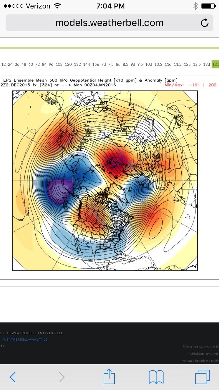
day 10 eps

day 15 gefs
heights continue to rise in w/can and Alaska. that would be a nice +pna/-epo couplet similar to our pattern last year. good to see lower heights in the east.

algae888- Advanced Forecaster

- Posts : 5311
Reputation : 46
Join date : 2013-02-05
Age : 61
Location : mt. vernon, new york
Re: Long Range Thread 9.0
![]() by algae888 Mon Dec 21, 2015 4:24 am
by algae888 Mon Dec 21, 2015 4:24 am
algae888- Advanced Forecaster
- Posts : 5311
Reputation : 46
Join date : 2013-02-05
Age : 61
Location : mt. vernon, new york
Re: Long Range Thread 9.0
![]() by algae888 Mon Dec 21, 2015 4:29 am
by algae888 Mon Dec 21, 2015 4:29 am
"The notion that the tropospheric pattern is hostile / very hostile until 1-2 weeks post stratospheric warming is a major myth. The actual research suggests that tropospheric changes usually occur weeks prior, and in some cases, tropospheric blocking was present for over a month before the actual warming event. The progression this winter looks quite similar to 1958 given the strong Nino / +QBO background state, though I continue to favor displacement over split. The NAM shifted largely negative by the second week of January in 1958, 3 weeks prior to the event. I expect a similar evolution here w/ the neutralization and biased negative NAM sometime in the second week of month [7th-14th]. Tomorrow night's weeklies should be interesting."
algae888- Advanced Forecaster
- Posts : 5311
Reputation : 46
Join date : 2013-02-05
Age : 61
Location : mt. vernon, new york
Re: Long Range Thread 9.0
![]() by Snow88 Mon Dec 21, 2015 9:19 am
by Snow88 Mon Dec 21, 2015 9:19 am
Snow88- Senior Enthusiast
- Posts : 2193
Reputation : 4
Join date : 2013-01-09
Age : 35
Location : Brooklyn, NY
Re: Long Range Thread 9.0
![]() by Guest Mon Dec 21, 2015 9:27 am
by Guest Mon Dec 21, 2015 9:27 am
Guest- Guest
Re: Long Range Thread 9.0
![]() by algae888 Mon Dec 21, 2015 11:13 am
by algae888 Mon Dec 21, 2015 11:13 am
algae888- Advanced Forecaster
- Posts : 5311
Reputation : 46
Join date : 2013-02-05
Age : 61
Location : mt. vernon, new york
Re: Long Range Thread 9.0
![]() by amugs Mon Dec 21, 2015 11:44 am
by amugs Mon Dec 21, 2015 11:44 am
algae888 wrote:Today's MJO forecast on the Euro continues moving it into phase 7 & 8 by day 14. The GFS has also followed suit except it collapses it once reaching phase 7 into the circle of death but it's moving more in line with the Euro the last several days. Can't post maps on my cell
_________________
Mugs
AKA:King: Snow Weenie
Self Proclaimed
WINTER 2014-15 : 55.12" +.02 for 6 coatings (avg. 35")
WINTER 2015-16 Total - 29.8" (Avg 35")
WINTER 2016-17 : 39.5" so far

amugs- Advanced Forecaster - Mod
- Posts : 15093
Reputation : 213
Join date : 2013-01-07
Age : 54
Location : Hillsdale,NJ
Re: Long Range Thread 9.0
![]() by amugs Mon Dec 21, 2015 11:44 am
by amugs Mon Dec 21, 2015 11:44 am
amugs wrote:algae888 wrote:Today's MJO forecast on the Euro continues moving it into phase 7 & 8 by day 14. The GFS has also followed suit except it collapses it once reaching phase 7 into the circle of death but it's moving more in line with the Euro the last several days. Can't post maps on my cell

_________________
Mugs
AKA:King: Snow Weenie
Self Proclaimed
WINTER 2014-15 : 55.12" +.02 for 6 coatings (avg. 35")
WINTER 2015-16 Total - 29.8" (Avg 35")
WINTER 2016-17 : 39.5" so far
amugs- Advanced Forecaster - Mod
- Posts : 15093
Reputation : 213
Join date : 2013-01-07
Age : 54
Location : Hillsdale,NJ
Re: Long Range Thread 9.0
![]() by amugs Mon Dec 21, 2015 11:55 am
by amugs Mon Dec 21, 2015 11:55 am

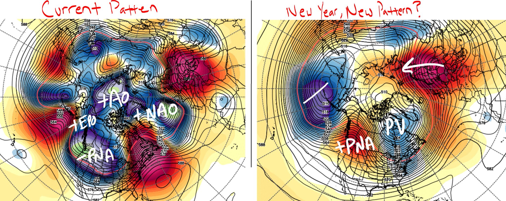
+PNA and the EPO or AL Vortext is retrograding away - if we can get that PNA to spike higher into Canada then we can get some cross polar flow - more of a seasonable map than a (possibly frigid) cold map - that comes by the 3-4 week in Jan and we go from there
_________________
Mugs
AKA:King: Snow Weenie
Self Proclaimed
WINTER 2014-15 : 55.12" +.02 for 6 coatings (avg. 35")
WINTER 2015-16 Total - 29.8" (Avg 35")
WINTER 2016-17 : 39.5" so far
amugs- Advanced Forecaster - Mod
- Posts : 15093
Reputation : 213
Join date : 2013-01-07
Age : 54
Location : Hillsdale,NJ
Re: Long Range Thread 9.0
![]() by Abba701 Mon Dec 21, 2015 12:04 pm
by Abba701 Mon Dec 21, 2015 12:04 pm
it's at least 75 in my opinion which is unbelievable.This is not normal at all.What is going on?CPcantmeasuresnow wrote:Abba701 wrote:Almost all forecasts now are forecasting 71 for a high on Thursday.So what's the highest that can be forecast? 75?80?
The highest Christmas Eve temperature ever is 63 so that seems like a lock to be shattered just like every other warm temperature record this month.
80 has never happened in December as a matter of fact it's only happened a couple of times in NOVEMBER and that was early in November, but since this December has acted like April I rule nothing out.
Abba701- Posts : 328
Reputation : 0
Join date : 2013-01-14
Re: Long Range Thread 9.0
![]() by NjWeatherGuy Mon Dec 21, 2015 12:13 pm
by NjWeatherGuy Mon Dec 21, 2015 12:13 pm
Go GFS, lol.amugs wrote:amugs wrote:algae888 wrote:Today's MJO forecast on the Euro continues moving it into phase 7 & 8 by day 14. The GFS has also followed suit except it collapses it once reaching phase 7 into the circle of death but it's moving more in line with the Euro the last several days. Can't post maps on my cell

NjWeatherGuy- Advanced Forecaster
- Posts : 4100
Reputation : 28
Join date : 2013-01-06
Location : Belle Mead, NJ
Re: Long Range Thread 9.0
![]() by elkiehound Mon Dec 21, 2015 5:14 pm
by elkiehound Mon Dec 21, 2015 5:14 pm
***JANUARY OUTLOOK***
The question on everyone's mind is, Where is winter in the eastern part of the US? Thanks to the "Super El Nino" (3 month average anomalies >2C) has kept the cold air locked up North. This month will likely go down as one of the least snowy Decembers for the region on record. Now what does this mean as we start heading into the heart of winter?
At this time we do still think on a monthly basis temperatures will still be above average but no where near the averages for December. Its toward the second half of the month when we are anticipating a change to a more active and cooler weather pattern. With the El Nino reaching its peak during the middle of December, we are looking at a quickly fading signal and that is a huge help for snow lovers on the shore. Fading El Nino's provide the potential for more high latitude blocking across Greenland.
A big player on the field that we are watching is the "Polar Vortex" (Stratosphere Vortex). You have heard about that term quite frequently the last few years that delivered extremely cold air to the lower 48. The stratosphere vortex this year has become very strong which is another reason why its been very warm in December as expected. The key player regarding the polar vortex is the something called a SSWE (Sudden Stratosphere Warming Event). A sudden stratospheric warming (SSW) is an event where the polar vortex of westerly winds in the winter hemisphere slows down or even reverses direction over the course of a few days. The change is accompanied by a rise of stratospheric temperature by several tens of kelvins.
Current and long range models have been showing the potential for such a warming event that will occur throughout the rest of the month heading into January. ECMWF and GFS models shows the polar vortex getting displaced from the polar regions southward toward North America. These changes in the vortex causes a complete pattern change in the Northern Hemisphere. There is usually a lag of about 7-14 days before we notice the changes. Climatology speaking, the precursors we are seeing now is a good sign of a nice SSW in the works. The effects of this event would begin to show itself after the 15th of January.
We will been keeping a close eye on what goes on with the stratosphere. Very hard at predicting what it will do.

elkiehound- Posts : 56
Reputation : 1
Join date : 2013-12-09
Location : Ringoes NJ
Re: Long Range Thread 9.0
![]() by chief7 Mon Dec 21, 2015 5:38 pm
by chief7 Mon Dec 21, 2015 5:38 pm
chief7- Posts : 132
Reputation : 0
Join date : 2013-11-10
Location : Langhorne pa
Re: Long Range Thread 9.0
![]() by sroc4 Mon Dec 21, 2015 5:49 pm
by sroc4 Mon Dec 21, 2015 5:49 pm
elkiehound wrote:From the DelMar Weather:
***JANUARY OUTLOOK***
The question on everyone's mind is, Where is winter in the eastern part of the US? Thanks to the "Super El Nino" (3 month average anomalies >2C) has kept the cold air locked up North. This month will likely go down as one of the least snowy Decembers for the region on record. Now what does this mean as we start heading into the heart of winter?
At this time we do still think on a monthly basis temperatures will still be above average but no where near the averages for December. Its toward the second half of the month when we are anticipating a change to a more active and cooler weather pattern. With the El Nino reaching its peak during the middle of December, we are looking at a quickly fading signal and that is a huge help for snow lovers on the shore. Fading El Nino's provide the potential for more high latitude blocking across Greenland.
A big player on the field that we are watching is the "Polar Vortex" (Stratosphere Vortex). You have heard about that term quite frequently the last few years that delivered extremely cold air to the lower 48. The stratosphere vortex this year has become very strong which is another reason why its been very warm in December as expected. The key player regarding the polar vortex is the something called a SSWE (Sudden Stratosphere Warming Event). A sudden stratospheric warming (SSW) is an event where the polar vortex of westerly winds in the winter hemisphere slows down or even reverses direction over the course of a few days. The change is accompanied by a rise of stratospheric temperature by several tens of kelvins.
Current and long range models have been showing the potential for such a warming event that will occur throughout the rest of the month heading into January. ECMWF and GFS models shows the polar vortex getting displaced from the polar regions southward toward North America. These changes in the vortex causes a complete pattern change in the Northern Hemisphere. There is usually a lag of about 7-14 days before we notice the changes. Climatology speaking, the precursors we are seeing now is a good sign of a nice SSW in the works. The effects of this event would begin to show itself after the 15th of January.
We will been keeping a close eye on what goes on with the stratosphere. Very hard at predicting what it will do.
Overall agrees with the discussions on our board. I do, however, disagree with the highlighted statement. The El Nino was not the cause of the record warmth, but rather the strong MJO pulses moving through phases 2-5 since early November and the +AO.
_________________
"In weather and in life, there's no winning and losing; there's only winning and learning."
WINTER 2012/2013 TOTALS 43.65"WINTER 2017/2018 TOTALS 62.85" WINTER 2022/2023 TOTALS 4.9"
WINTER 2013/2014 TOTALS 64.85"WINTER 2018/2019 TOTALS 14.25" WINTER 2023/2024 TOTALS 13.1"
WINTER 2014/2015 TOTALS 71.20"WINTER 2019/2020 TOTALS 6.35"
WINTER 2015/2016 TOTALS 35.00"WINTER 2020/2021 TOTALS 37.75"
WINTER 2016/2017 TOTALS 42.25"WINTER 2021/2022 TOTALS 31.65"

sroc4- Admin

- Posts : 8331
Reputation : 301
Join date : 2013-01-07
Location : Wading River, LI
Re: Long Range Thread 9.0
![]() by sroc4 Mon Dec 21, 2015 7:08 pm
by sroc4 Mon Dec 21, 2015 7:08 pm
_________________
"In weather and in life, there's no winning and losing; there's only winning and learning."
WINTER 2012/2013 TOTALS 43.65"WINTER 2017/2018 TOTALS 62.85" WINTER 2022/2023 TOTALS 4.9"
WINTER 2013/2014 TOTALS 64.85"WINTER 2018/2019 TOTALS 14.25" WINTER 2023/2024 TOTALS 13.1"
WINTER 2014/2015 TOTALS 71.20"WINTER 2019/2020 TOTALS 6.35"
WINTER 2015/2016 TOTALS 35.00"WINTER 2020/2021 TOTALS 37.75"
WINTER 2016/2017 TOTALS 42.25"WINTER 2021/2022 TOTALS 31.65"
sroc4- Admin
- Posts : 8331
Reputation : 301
Join date : 2013-01-07
Location : Wading River, LI
Re: Long Range Thread 9.0
![]() by amugs Mon Dec 21, 2015 7:46 pm
by amugs Mon Dec 21, 2015 7:46 pm
sroc4 wrote:Man this really has a nice look. Look at that EPO ridge and notice how it try to connect to the ridge on the other side of the Arctic. Can anyone say cross polar flow? It really is coming.
yes great look, went over this with me weather club after school, the good ol' polar bridge that will connect the pna, epo to the scandaVian block. As I have been harping on since August that the AL vortex that killed is in Dec is retrograding sw as can be seen by its location on, southwest of the aluetians. Thus will allow the pna to go positive, epo neg whilst a neg trough bills over the se. Gives us good chances and IF and I think it will happen the AO goes neg by mid month we dance like it's 1999 (prince song??) I know we are all spooks bt Dec and it is easy to say warm and wet but fir crying all night have some brass ones and put out positive juju and let's make a come back like the Americans in the South Pacific in WW2!!!
Back to Bauleys, Cannoli's, Egg Nog and Shrimp.scampi!!
_________________
Mugs
AKA:King: Snow Weenie
Self Proclaimed
WINTER 2014-15 : 55.12" +.02 for 6 coatings (avg. 35")
WINTER 2015-16 Total - 29.8" (Avg 35")
WINTER 2016-17 : 39.5" so far
amugs- Advanced Forecaster - Mod
- Posts : 15093
Reputation : 213
Join date : 2013-01-07
Age : 54
Location : Hillsdale,NJ
Re: Long Range Thread 9.0
![]() by amugs Mon Dec 21, 2015 7:52 pm
by amugs Mon Dec 21, 2015 7:52 pm
http://www.aer.com/science-research/climate-weather/arctic-oscillation
We have been discussing the polar vortex model developed here at AER that predicts the strength of the polar vortex one month in advance. As we discussed in the blog for the past month, the model was predicting the polar vortex to become disturbed the third week of December, which is predicted by the weather models to occur this week. The polar vortex model also predicts a similar perturbing of the stratospheric polar vortex in the first week of January, which again is now being predicted by the weather models. And as we have been discussing, the polar vortex model predicts an even bigger event the second week of January. As we discussed above the predicted atmospheric circulation is nearly optimal for the vertical transfer of energy from the troposphere to the stratosphere that results in weakening of the polar vortex.
Bring it on baby!!
Back to my Xmass Chores!
_________________
Mugs
AKA:King: Snow Weenie
Self Proclaimed
WINTER 2014-15 : 55.12" +.02 for 6 coatings (avg. 35")
WINTER 2015-16 Total - 29.8" (Avg 35")
WINTER 2016-17 : 39.5" so far
amugs- Advanced Forecaster - Mod
- Posts : 15093
Reputation : 213
Join date : 2013-01-07
Age : 54
Location : Hillsdale,NJ
Re: Long Range Thread 9.0
![]() by amugs Mon Dec 21, 2015 8:06 pm
by amugs Mon Dec 21, 2015 8:06 pm
"We aren't going back to square one. From Cohen, there are two more attacks to polar vortex forecast to be coming during the first two weeks of January."


_________________
Mugs
AKA:King: Snow Weenie
Self Proclaimed
WINTER 2014-15 : 55.12" +.02 for 6 coatings (avg. 35")
WINTER 2015-16 Total - 29.8" (Avg 35")
WINTER 2016-17 : 39.5" so far
amugs- Advanced Forecaster - Mod
- Posts : 15093
Reputation : 213
Join date : 2013-01-07
Age : 54
Location : Hillsdale,NJ
Re: Long Range Thread 9.0
![]() by amugs Mon Dec 21, 2015 8:34 pm
by amugs Mon Dec 21, 2015 8:34 pm

_________________
Mugs
AKA:King: Snow Weenie
Self Proclaimed
WINTER 2014-15 : 55.12" +.02 for 6 coatings (avg. 35")
WINTER 2015-16 Total - 29.8" (Avg 35")
WINTER 2016-17 : 39.5" so far
amugs- Advanced Forecaster - Mod
- Posts : 15093
Reputation : 213
Join date : 2013-01-07
Age : 54
Location : Hillsdale,NJ
Re: Long Range Thread 9.0
![]() by amugs Mon Dec 21, 2015 8:53 pm
by amugs Mon Dec 21, 2015 8:53 pm
_________________
Mugs
AKA:King: Snow Weenie
Self Proclaimed
WINTER 2014-15 : 55.12" +.02 for 6 coatings (avg. 35")
WINTER 2015-16 Total - 29.8" (Avg 35")
WINTER 2016-17 : 39.5" so far
amugs- Advanced Forecaster - Mod
- Posts : 15093
Reputation : 213
Join date : 2013-01-07
Age : 54
Location : Hillsdale,NJ
Re: Long Range Thread 9.0
![]() by HectorO Mon Dec 21, 2015 8:57 pm
by HectorO Mon Dec 21, 2015 8:57 pm

HectorO- Pro Enthusiast

- Posts : 959
Reputation : 27
Join date : 2013-01-11
Re: Long Range Thread 9.0
![]() by Frank_Wx Mon Dec 21, 2015 9:16 pm
by Frank_Wx Mon Dec 21, 2015 9:16 pm
_________________
_______________________________________________________________________________________________________
CLICK HERE to view NJ Strong Snowstorm Classifications

Frank_Wx- Godzilla Seeker
- Posts : 21305
Reputation : 328
Join date : 2013-01-05
Age : 31
Location : Jersey City, NJ -

Page 25 of 40 • 1 ... 14 ... 24, 25, 26 ... 32 ... 40 ![]()
|
|
|