
 Search
Long Range Thread 9.0
Page 34 of 40 •  1 ... 18 ... 33, 34, 35 ... 40
 ![]()
Re: Long Range Thread 9.0
![]() by weatherwatchermom Tue Dec 29, 2015 1:26 pm
by weatherwatchermom Tue Dec 29, 2015 1:26 pm
weatherwatchermom- Senior Enthusiast

- Posts : 3750
Join date : 2014-11-25
Re: Long Range Thread 9.0
![]() by algae888 Tue Dec 29, 2015 1:29 pm
by algae888 Tue Dec 29, 2015 1:29 pm
algae888- Advanced Forecaster

- Posts : 5311
Join date : 2013-02-05
Re: Long Range Thread 9.0
![]() by skinsfan1177 Tue Dec 29, 2015 2:27 pm
by skinsfan1177 Tue Dec 29, 2015 2:27 pm
algae888 wrote:The next 10 days or so we have very little chance of seeing any snow as the pattern will be transitioning. After that my big concern is suppression. If you look at the end of today's 12z GFS run the 0 degrees Celsius line is in northern Florida. Many of the ensembles show a similar outcome. Just because the models are showing the perfect pattern doesn't necessarily mean we snow here. As I lived through many winters with very little snow here, timing is always of the utmost importance. Whether a crappy pattern or a good pattern that's what's going to make the difference. Sadly no one can predict timing more than a few days out
This was a question I asked a day or two ago? I hope not

skinsfan1177- Senior Enthusiast
- Posts : 4485
Reputation : 35
Join date : 2013-01-07
Age : 46
Location : Point Pleasant Boro
Re: Long Range Thread 9.0
![]() by skinsfan1177 Tue Dec 29, 2015 2:29 pm
by skinsfan1177 Tue Dec 29, 2015 2:29 pm
I believe soweatherwatchermom wrote:hey silly question..when you guys talk about JB are you talking about Joe Bastardi?
skinsfan1177- Senior Enthusiast
- Posts : 4485
Reputation : 35
Join date : 2013-01-07
Age : 46
Location : Point Pleasant Boro
Re: Long Range Thread 9.0
![]() by nutleyblizzard Tue Dec 29, 2015 3:01 pm
by nutleyblizzard Tue Dec 29, 2015 3:01 pm

nutleyblizzard- Senior Enthusiast
- Posts : 1952
Reputation : 41
Join date : 2014-01-30
Age : 58
Location : Nutley, new jersey
Re: Long Range Thread 9.0
![]() by sroc4 Tue Dec 29, 2015 3:10 pm
by sroc4 Tue Dec 29, 2015 3:10 pm
weatherwatchermom wrote:hey silly question..when you guys talk about JB are you talking about Joe Bastardi?
Yes JB refers to Joe Bastardi.
_________________
"In weather and in life, there's no winning and losing; there's only winning and learning."
WINTER 2012/2013 TOTALS 43.65"WINTER 2017/2018 TOTALS 62.85" WINTER 2022/2023 TOTALS 4.9"
WINTER 2013/2014 TOTALS 64.85"WINTER 2018/2019 TOTALS 14.25" WINTER 2023/2024 TOTALS 13.1"
WINTER 2014/2015 TOTALS 71.20"WINTER 2019/2020 TOTALS 6.35"
WINTER 2015/2016 TOTALS 35.00"WINTER 2020/2021 TOTALS 37.75"
WINTER 2016/2017 TOTALS 42.25"WINTER 2021/2022 TOTALS 31.65"

sroc4- Admin

- Posts : 8331
Reputation : 301
Join date : 2013-01-07
Location : Wading River, LI
Re: Long Range Thread 9.0
![]() by algae888 Tue Dec 29, 2015 3:22 pm
by algae888 Tue Dec 29, 2015 3:22 pm


algae888- Advanced Forecaster
- Posts : 5311
Reputation : 46
Join date : 2013-02-05
Age : 61
Location : mt. vernon, new york
Re: Long Range Thread 9.0
![]() by algae888 Tue Dec 29, 2015 3:42 pm
by algae888 Tue Dec 29, 2015 3:42 pm
algae888- Advanced Forecaster
- Posts : 5311
Reputation : 46
Join date : 2013-02-05
Age : 61
Location : mt. vernon, new york
Re: Long Range Thread 9.0
![]() by Dtone Tue Dec 29, 2015 3:49 pm
by Dtone Tue Dec 29, 2015 3:49 pm
but will it tip things in our favor?
https://www.washingtonpost.com/news/capital-weather-gang/wp/2015/12/28/freak-storm-in-north-atlantic-may-push-temperatures-70-degrees-above-normal-at-north-pole/
Dtone- Wx Statistician Guru

- Posts : 1738
Reputation : 9
Join date : 2013-08-26
Location : Bronx, NY
Re: Long Range Thread 9.0
![]() by Frank_Wx Tue Dec 29, 2015 4:05 pm
by Frank_Wx Tue Dec 29, 2015 4:05 pm
Hate to do this, but here it is:
Since 1900 (115 years), there have been 17 winters with .1" or less in NYC for the month of December.
Dec. Snowfall:/Entire Winter Snowfall
1900-1901: .1"/9.1"
1931-1932: .1"/5.3"
1936-1937: T/15.6"
1943-1944: T/23.8"
1953-1954: T/15.8"
1954-1955: .1"/11.5"
1965-1966: T/21.4"
1971-1972: T/22.9"
1972-1973: T/2.8"
1974-1975: .1"/13.1"
1994-1995: T/11.8"
1996-1997: T/10.0"
1997-1998: T/5.5"
1999-2000: T/16.3"
2001-2002: T/3.5"
2006-2007: 0/12.4"
2011-2012: 0/7.4"
2015-2016: T/???
Total: 208.2"
Average: 12.2"
_________________
_______________________________________________________________________________________________________
CLICK HERE to view NJ Strong Snowstorm Classifications

Frank_Wx- Godzilla Seeker
- Posts : 21305
Reputation : 328
Join date : 2013-01-05
Age : 31
Location : Jersey City, NJ -

Re: Long Range Thread 9.0
![]() by weatherwatchermom Tue Dec 29, 2015 4:07 pm
by weatherwatchermom Tue Dec 29, 2015 4:07 pm
Thank you..watched him today on WSJ Lunchbreaksroc4 wrote:weatherwatchermom wrote:hey silly question..when you guys talk about JB are you talking about Joe Bastardi?
Yes JB refers to Joe Bastardi.
JB gave a report today:
http://www.wsj.com/video/extreme-weather-forecast-for-2016/9F232FDD-B94D-4345-9053-C2A44E3D794B.html
Last edited by weatherwatchermom on Tue Dec 29, 2015 4:13 pm; edited 1 time in total

weatherwatchermom- Senior Enthusiast
- Posts : 3750
Reputation : 77
Join date : 2014-11-25
Age : 60
Location : Hazlet Township, NJ
Re: Long Range Thread 9.0
![]() by weatherwatchermom Tue Dec 29, 2015 4:12 pm
by weatherwatchermom Tue Dec 29, 2015 4:12 pm
skinsfan1177 wrote:I believe soweatherwatchermom wrote:hey silly question..when you guys talk about JB are you talking about Joe Bastardi?
thanks....watched his take on upcoming winter changes:
http://www.wsj.com/video/extreme-weather-forecast-for-2016/9F232FDD-B94D-4345-9053-C2A44E3D794B.html
weatherwatchermom- Senior Enthusiast
- Posts : 3750
Reputation : 77
Join date : 2014-11-25
Age : 60
Location : Hazlet Township, NJ
Re: Long Range Thread 9.0
![]() by sroc4 Tue Dec 29, 2015 4:17 pm
by sroc4 Tue Dec 29, 2015 4:17 pm
algae888 wrote:The next 10 days or so we have very little chance of seeing any snow as the pattern will be transitioning. After that my big concern is suppression. If you look at the end of today's 12z GFS run the 0 degrees Celsius line is in northern Florida. Many of the ensembles show a similar outcome. Just because the models are showing the perfect pattern doesn't necessarily mean we snow here. As I lived through many winters with very little snow here, timing is always of the utmost importance. Whether a crappy pattern or a good pattern that's what's going to make the difference. Sadly no one can predict timing more than a few days out
You may be right about suppression Al but I certainly would not look at the LR GFS to tell you if that's going to happen. With an active STJ and the potential for a neg NAO suppression may not be the case at all. In years past the lack of the -NAO has led to the energy in the southern stream to escape OTS before the northern stream s/w could dig into the south and phase the two streams. Timing had to be perfect because if the southern energy was out ahead of the N energy at all there was nothing to slow it down to allow the phase. Instead we would get cold fronts that would push through as the N energy moved east, and stall just to our south. Weak waves of LP developed along the fronts and rode along them and overrunning events that were enhanced by the strong baroclinic zones occured. Juno last ear was a result of perfect timing between the N and southern branch but ultimately the progressiveness of the pattern (lack of a neg NAO) kept it too far east for main impacts. If the PV sank too far south and or East these fronts would sag too far south and the energy could pass well to our south leading to cold and dry. That def happened in the past two years at times. However, In this type of pattern with an active STJ you get a strong southern disturbance that is less likely to just shoot OTS because its not a progressive pattern, but one that turns the jets more south to north instead of sw to NE or even W to E. this allows more time for the northern stream s/w to catch up and phase. Not saying its going to happen but timing becomes much less of an issue with that type of blocking set up.
Now remember this. Sometimes you need the cold before you get the snow.
EPS Day 6 500mb anomalies: Notice the western Can ridge is drifting east centered over central Canada.
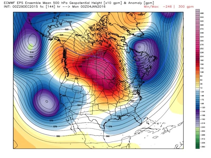 " />
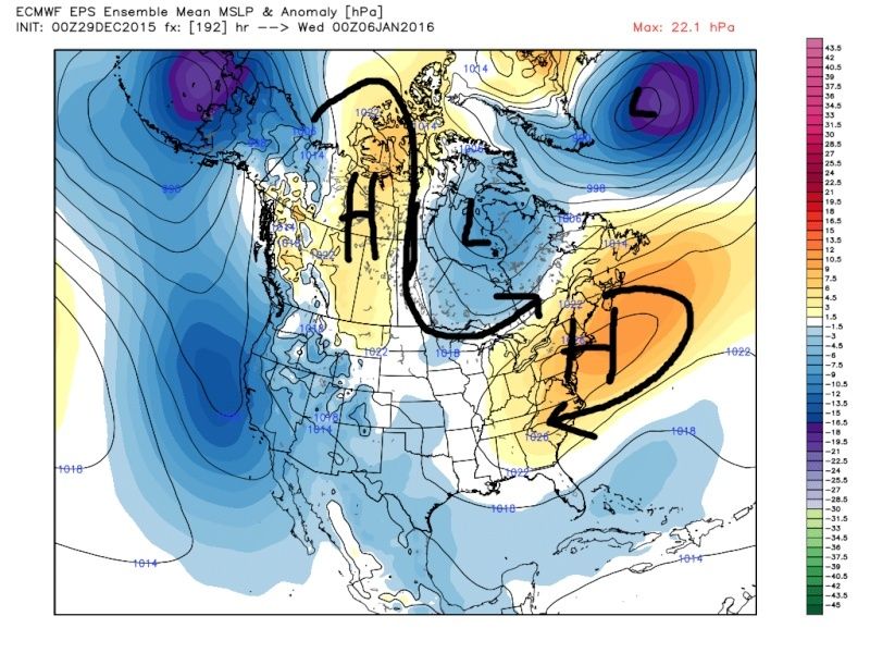
" /> This promotes a Canadian HP to drop into the central plains and cold air into the NE. This is the EPS MSLP(Mean Surface Low Pressure) anomaly map:
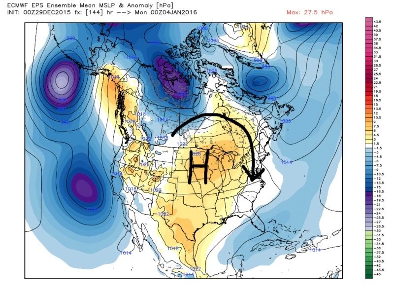 " />
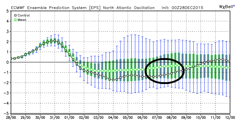
" />By Day 8 the 500mb Ridge continues to drift east and the surface HP is on the move east because the pattern is not quite there yet: But notice how there is already another 500mb ridge, and Canadian surface HP building in NW Canada as the first ridge and surface HP moving off the NE coast. In addition we are starting to see signs of a -NAO.
 " />
" /> " />
" /> " />
" /> " />
" />For me I see the potential by day 10 for a threat for possible snow. Its a long way off but verbatim on the EPS the potential is there.
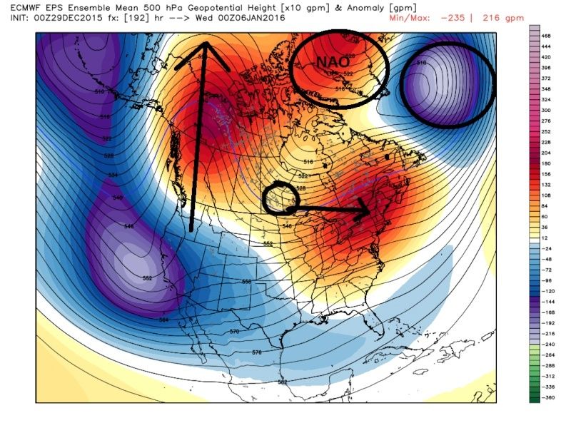
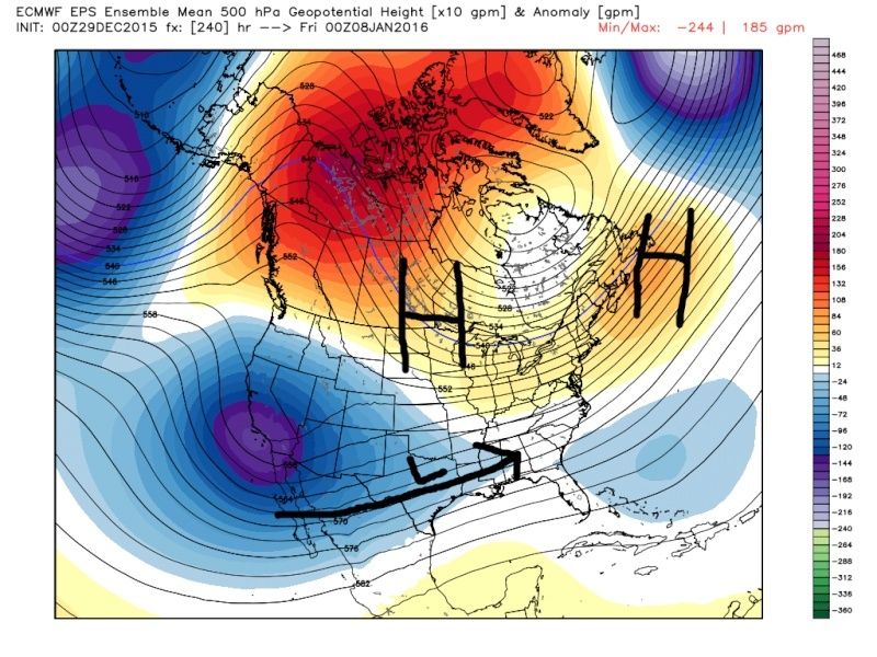
Day 10 at 500mb we have a strong ridge well up into NW Can and Alaska and is beginning to truly bridge over top the artic. Heights are raised into the NAO region as well. It appears we have pieces of energy breaking off the energy in the SW compliments of the STJ. Another strong HP dropping into the plains; along with it an injection of true arctic air. It also promotes a HP to the NE of New England that could serve as a block to any energy coming out of the STJ.
 " />
" />MSLP Anomaly:
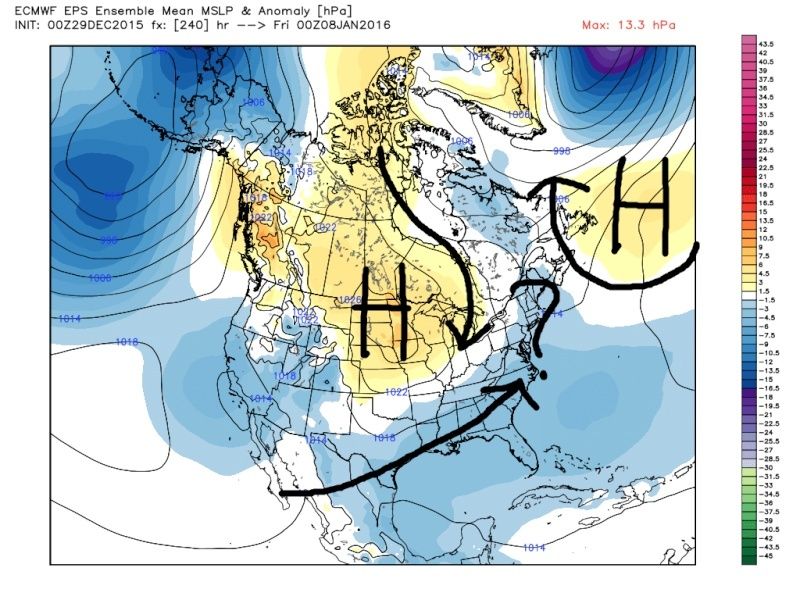 " />
" />Forget about it if the 15day works out. This is almost perfect. This would be a phased northern and southern branch with a cross polar flow. Any energy that comes out of the STJ phases, trough goes negantive, and LP turns up the coast.
 " />
" />Last edited by sroc4 on Tue Dec 29, 2015 4:19 pm; edited 1 time in total
_________________
"In weather and in life, there's no winning and losing; there's only winning and learning."
WINTER 2012/2013 TOTALS 43.65"WINTER 2017/2018 TOTALS 62.85" WINTER 2022/2023 TOTALS 4.9"
WINTER 2013/2014 TOTALS 64.85"WINTER 2018/2019 TOTALS 14.25" WINTER 2023/2024 TOTALS 13.1"
WINTER 2014/2015 TOTALS 71.20"WINTER 2019/2020 TOTALS 6.35"
WINTER 2015/2016 TOTALS 35.00"WINTER 2020/2021 TOTALS 37.75"
WINTER 2016/2017 TOTALS 42.25"WINTER 2021/2022 TOTALS 31.65"
sroc4- Admin
- Posts : 8331
Reputation : 301
Join date : 2013-01-07
Location : Wading River, LI
Re: Long Range Thread 9.0
![]() by skinsfan1177 Tue Dec 29, 2015 4:18 pm
by skinsfan1177 Tue Dec 29, 2015 4:18 pm
Isn't this bad news as far as pattern flippingalgae888 wrote:7-10 ensemble mean. looks like current pattern. at least the ridge over the n/e...
skinsfan1177- Senior Enthusiast
- Posts : 4485
Reputation : 35
Join date : 2013-01-07
Age : 46
Location : Point Pleasant Boro
Re: Long Range Thread 9.0
![]() by sroc4 Tue Dec 29, 2015 4:26 pm
by sroc4 Tue Dec 29, 2015 4:26 pm
algae888 wrote:7-10 ensemble mean. looks like current pattern. at least the ridge over the n/e...
HUGE difference compared to current pattern Al. Look at the red over the arctic. That tells you that the ridge you see in the NE is transient. Not going to last,maybe 24-36hrs. Will likely trend colder over time because another cold Canadian HP is set to drop into the conus right after. I explain it in a little more detail in my post above.
_________________
"In weather and in life, there's no winning and losing; there's only winning and learning."
WINTER 2012/2013 TOTALS 43.65"WINTER 2017/2018 TOTALS 62.85" WINTER 2022/2023 TOTALS 4.9"
WINTER 2013/2014 TOTALS 64.85"WINTER 2018/2019 TOTALS 14.25" WINTER 2023/2024 TOTALS 13.1"
WINTER 2014/2015 TOTALS 71.20"WINTER 2019/2020 TOTALS 6.35"
WINTER 2015/2016 TOTALS 35.00"WINTER 2020/2021 TOTALS 37.75"
WINTER 2016/2017 TOTALS 42.25"WINTER 2021/2022 TOTALS 31.65"
sroc4- Admin
- Posts : 8331
Reputation : 301
Join date : 2013-01-07
Location : Wading River, LI
Re: Long Range Thread 9.0
![]() by sroc4 Tue Dec 29, 2015 4:30 pm
by sroc4 Tue Dec 29, 2015 4:30 pm
[img]
 [/img]
Day 10 Pattern:
[img]
 [/img]
_________________
"In weather and in life, there's no winning and losing; there's only winning and learning."
WINTER 2012/2013 TOTALS 43.65"WINTER 2017/2018 TOTALS 62.85" WINTER 2022/2023 TOTALS 4.9"
WINTER 2013/2014 TOTALS 64.85"WINTER 2018/2019 TOTALS 14.25" WINTER 2023/2024 TOTALS 13.1"
WINTER 2014/2015 TOTALS 71.20"WINTER 2019/2020 TOTALS 6.35"
WINTER 2015/2016 TOTALS 35.00"WINTER 2020/2021 TOTALS 37.75"
WINTER 2016/2017 TOTALS 42.25"WINTER 2021/2022 TOTALS 31.65"
sroc4- Admin
- Posts : 8331
Reputation : 301
Join date : 2013-01-07
Location : Wading River, LI
Re: Long Range Thread 9.0
![]() by Frank_Wx Tue Dec 29, 2015 4:34 pm
by Frank_Wx Tue Dec 29, 2015 4:34 pm
sroc4 wrote:algae888 wrote:7-10 ensemble mean. looks like current pattern. at least the ridge over the n/e...
HUGE difference compared to current pattern Al. Look at the red over the arctic. That tells you that the ridge you see in the NE is transient. Not going to last,maybe 24-36hrs. Will likely trend colder over time because another cold Canadian HP is set to drop into the conus right after. I explain it in a little more detail in my post above.
This is not a shock if you read my latest Mo Mo, where I posted this image showing exactly what the Ensembles are showing.
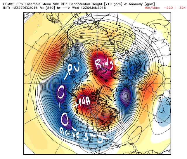
There is a strong upper level energy breaking off the Siberian PV and working it's way into the SW CONUS to bring about a -PNA. As noted in the blog, this is part of the pattern transition. The -EPO/-AO is establishing itself over Canada and the Arctic. The Aleutian trough won't become better defined or organized until the EPO ridge retrogrades more into Alaska. This is where we need the Stratosphere to come in. If there's a Strat PV split, the Siberian vortex should break down or turn into an anomalous Aleutian trough. Thus, the first 10-12 days of January should average out to nornal. There will be some cold and mild days.
I still expect a pattern change to colder than normal weather to occur between January 12th and 15th, with a full scale pattern change involving the Stratosphere around January 20th-24th.
What I'm seeing in the LR is to be expected. No surprises.
P.S. - post was more directed to Al. Scott sees the pattern well.
_________________
_______________________________________________________________________________________________________
CLICK HERE to view NJ Strong Snowstorm Classifications
Frank_Wx- Godzilla Seeker
- Posts : 21305
Reputation : 328
Join date : 2013-01-05
Age : 31
Location : Jersey City, NJ -
Re: Long Range Thread 9.0
![]() by sroc4 Tue Dec 29, 2015 4:41 pm
by sroc4 Tue Dec 29, 2015 4:41 pm
Frank_Wx wrote:Someone verify if this post made on another board is correct. We have great historians here who could probably do this quick:
Hate to do this, but here it is:
Since 1900 (115 years), there have been 17 winters with .1" or less in NYC for the month of December.
Dec. Snowfall:/Entire Winter Snowfall
1900-1901: .1"/9.1"
1931-1932: .1"/5.3"
1936-1937: T/15.6"
1943-1944: T/23.8"
1953-1954: T/15.8"
1954-1955: .1"/11.5"
1965-1966: T/21.4"
1971-1972: T/22.9"
1972-1973: T/2.8"
1974-1975: .1"/13.1"
1994-1995: T/11.8"
1996-1997: T/10.0"
1997-1998: T/5.5"
1999-2000: T/16.3"
2001-2002: T/3.5"
2006-2007: 0/12.4"
2011-2012: 0/7.4"
2015-2016: T/???
Total: 208.2"
Average: 12.2"
True story Frank: http://www.weather.gov/media/okx/Climate/CentralPark/monthlyseasonalsnowfall.pdf
_________________
"In weather and in life, there's no winning and losing; there's only winning and learning."
WINTER 2012/2013 TOTALS 43.65"WINTER 2017/2018 TOTALS 62.85" WINTER 2022/2023 TOTALS 4.9"
WINTER 2013/2014 TOTALS 64.85"WINTER 2018/2019 TOTALS 14.25" WINTER 2023/2024 TOTALS 13.1"
WINTER 2014/2015 TOTALS 71.20"WINTER 2019/2020 TOTALS 6.35"
WINTER 2015/2016 TOTALS 35.00"WINTER 2020/2021 TOTALS 37.75"
WINTER 2016/2017 TOTALS 42.25"WINTER 2021/2022 TOTALS 31.65"
sroc4- Admin
- Posts : 8331
Reputation : 301
Join date : 2013-01-07
Location : Wading River, LI
Re: Long Range Thread 9.0
![]() by Frank_Wx Tue Dec 29, 2015 4:55 pm
by Frank_Wx Tue Dec 29, 2015 4:55 pm
sroc4 wrote:Frank_Wx wrote:Someone verify if this post made on another board is correct. We have great historians here who could probably do this quick:
Hate to do this, but here it is:
Since 1900 (115 years), there have been 17 winters with .1" or less in NYC for the month of December.
Dec. Snowfall:/Entire Winter Snowfall
1900-1901: .1"/9.1"
1931-1932: .1"/5.3"
1936-1937: T/15.6"
1943-1944: T/23.8"
1953-1954: T/15.8"
1954-1955: .1"/11.5"
1965-1966: T/21.4"
1971-1972: T/22.9"
1972-1973: T/2.8"
1974-1975: .1"/13.1"
1994-1995: T/11.8"
1996-1997: T/10.0"
1997-1998: T/5.5"
1999-2000: T/16.3"
2001-2002: T/3.5"
2006-2007: 0/12.4"
2011-2012: 0/7.4"
2015-2016: T/???
Total: 208.2"
Average: 12.2"
True story Frank: http://www.weather.gov/media/okx/Climate/CentralPark/monthlyseasonalsnowfall.pdf
Well I'm pretty much guaranteeing we see more than 24 inches of snow in CPK. These type of things are meant to be broken.
_________________
_______________________________________________________________________________________________________
CLICK HERE to view NJ Strong Snowstorm Classifications
Frank_Wx- Godzilla Seeker
- Posts : 21305
Reputation : 328
Join date : 2013-01-05
Age : 31
Location : Jersey City, NJ -
Re: Long Range Thread 9.0
![]() by sroc4 Tue Dec 29, 2015 4:57 pm
by sroc4 Tue Dec 29, 2015 4:57 pm
Couldn't agree more. Maybe in one storm.Frank_Wx wrote:sroc4 wrote:Frank_Wx wrote:Someone verify if this post made on another board is correct. We have great historians here who could probably do this quick:
Hate to do this, but here it is:
Since 1900 (115 years), there have been 17 winters with .1" or less in NYC for the month of December.
Dec. Snowfall:/Entire Winter Snowfall
1900-1901: .1"/9.1"
1931-1932: .1"/5.3"
1936-1937: T/15.6"
1943-1944: T/23.8"
1953-1954: T/15.8"
1954-1955: .1"/11.5"
1965-1966: T/21.4"
1971-1972: T/22.9"
1972-1973: T/2.8"
1974-1975: .1"/13.1"
1994-1995: T/11.8"
1996-1997: T/10.0"
1997-1998: T/5.5"
1999-2000: T/16.3"
2001-2002: T/3.5"
2006-2007: 0/12.4"
2011-2012: 0/7.4"
2015-2016: T/???
Total: 208.2"
Average: 12.2"
True story Frank: http://www.weather.gov/media/okx/Climate/CentralPark/monthlyseasonalsnowfall.pdf
Well I'm pretty much guaranteeing we see more than 24 inches of snow in CPK. These type of things are meant to be broken.
_________________
"In weather and in life, there's no winning and losing; there's only winning and learning."
WINTER 2012/2013 TOTALS 43.65"WINTER 2017/2018 TOTALS 62.85" WINTER 2022/2023 TOTALS 4.9"
WINTER 2013/2014 TOTALS 64.85"WINTER 2018/2019 TOTALS 14.25" WINTER 2023/2024 TOTALS 13.1"
WINTER 2014/2015 TOTALS 71.20"WINTER 2019/2020 TOTALS 6.35"
WINTER 2015/2016 TOTALS 35.00"WINTER 2020/2021 TOTALS 37.75"
WINTER 2016/2017 TOTALS 42.25"WINTER 2021/2022 TOTALS 31.65"
sroc4- Admin
- Posts : 8331
Reputation : 301
Join date : 2013-01-07
Location : Wading River, LI
Re: Long Range Thread 9.0
![]() by amugs Tue Dec 29, 2015 5:14 pm
by amugs Tue Dec 29, 2015 5:14 pm
http://www.aer.com/science-research/climate-weather/arctic-oscillation
_________________
Mugs
AKA:King: Snow Weenie
Self Proclaimed
WINTER 2014-15 : 55.12" +.02 for 6 coatings (avg. 35")
WINTER 2015-16 Total - 29.8" (Avg 35")
WINTER 2016-17 : 39.5" so far

amugs- Advanced Forecaster - Mod

- Posts : 15093
Reputation : 213
Join date : 2013-01-07
Age : 54
Location : Hillsdale,NJ
Re: Long Range Thread 9.0
![]() by skinsfan1177 Tue Dec 29, 2015 5:22 pm
by skinsfan1177 Tue Dec 29, 2015 5:22 pm
amugs wrote:Good discussion, Al the pattern change is coming Euro Para is going to school the model means. There will be chances for storms - the AL Low slides SSW of the Aleutians and that will help pump the ridge on the West coast opening up the STJ to travel in a ENE direction across the southernmost tier of America. -AO sitting in Hudson Bay not in the GL if so we need a lot of chap stick and Vaseline but that doesn't look to happen. Lets get the cold air first and then we get the storms and Mr.Cohen should help with his latest write up:
http://www.aer.com/science-research/climate-weather/arctic-oscillation
Amugs when do think in your opinion we see the white gold?
skinsfan1177- Senior Enthusiast
- Posts : 4485
Reputation : 35
Join date : 2013-01-07
Age : 46
Location : Point Pleasant Boro
Re: Long Range Thread 9.0
![]() by Mathgod55 Tue Dec 29, 2015 6:07 pm
by Mathgod55 Tue Dec 29, 2015 6:07 pm

Mathgod55- Posts : 60
Reputation : 0
Join date : 2013-01-08
Location : West Islip, NyY
Re: Long Range Thread 9.0
![]() by CPcantmeasuresnow Tue Dec 29, 2015 6:18 pm
by CPcantmeasuresnow Tue Dec 29, 2015 6:18 pm
sroc4 wrote:Couldn't agree more. Maybe in one storm.Frank_Wx wrote:sroc4 wrote:Frank_Wx wrote:Someone verify if this post made on another board is correct. We have great historians here who could probably do this quick:
Hate to do this, but here it is:
Since 1900 (115 years), there have been 17 winters with .1" or less in NYC for the month of December.
Dec. Snowfall:/Entire Winter Snowfall
1900-1901: .1"/9.1"
1931-1932: .1"/5.3"
1936-1937: T/15.6"
1943-1944: T/23.8"
1953-1954: T/15.8"
1954-1955: .1"/11.5"
1965-1966: T/21.4"
1971-1972: T/22.9"
1972-1973: T/2.8"
1974-1975: .1"/13.1"
1994-1995: T/11.8"
1996-1997: T/10.0"
1997-1998: T/5.5"
1999-2000: T/16.3"
2001-2002: T/3.5"
2006-2007: 0/12.4"
2011-2012: 0/7.4"
2015-2016: T/???
Total: 208.2"
Average: 12.2"
True story Frank: http://www.weather.gov/media/okx/Climate/CentralPark/monthlyseasonalsnowfall.pdf
Well I'm pretty much guaranteeing we see more than 24 inches of snow in CPK. These type of things are meant to be broken.
It is correct. I believe I posted something similar to this if not exactly this during the winter of 2011/12.
This isn't the same as the December prognosticator but it's a bad omen nonetheless. Streaks are made to be broken however, and we certainly shattered the December prognosticators streak last year.
Last edited by CPcantmeasuresnow on Tue Dec 29, 2015 6:25 pm; edited 2 times in total

CPcantmeasuresnow- Wx Statistician Guru
- Posts : 7274
Reputation : 230
Join date : 2013-01-07
Age : 103
Location : Eastern Orange County, NY
Re: Long Range Thread 9.0
![]() by chief7 Tue Dec 29, 2015 6:22 pm
by chief7 Tue Dec 29, 2015 6:22 pm
chief7- Posts : 132
Reputation : 0
Join date : 2013-11-10
Location : Langhorne pa
Re: Long Range Thread 9.0
![]() by CPcantmeasuresnow Tue Dec 29, 2015 6:30 pm
by CPcantmeasuresnow Tue Dec 29, 2015 6:30 pm
chief7 wrote:Another plus for the cold air that is coming, natural gas for February delivery is up 37% in the last 8 days in heavy trading in a time of year when we don't really see heavy trading a quote from another board
Hey Docstox!!!!
How about a warning next time. I could have joined you in retirement.
CPcantmeasuresnow- Wx Statistician Guru
- Posts : 7274
Reputation : 230
Join date : 2013-01-07
Age : 103
Location : Eastern Orange County, NY
Re: Long Range Thread 9.0
![]() by Frank_Wx Tue Dec 29, 2015 7:10 pm
by Frank_Wx Tue Dec 29, 2015 7:10 pm
Frank_Wx wrote:sroc4 wrote:algae888 wrote:7-10 ensemble mean. looks like current pattern. at least the ridge over the n/e...
HUGE difference compared to current pattern Al. Look at the red over the arctic. That tells you that the ridge you see in the NE is transient. Not going to last,maybe 24-36hrs. Will likely trend colder over time because another cold Canadian HP is set to drop into the conus right after. I explain it in a little more detail in my post above.
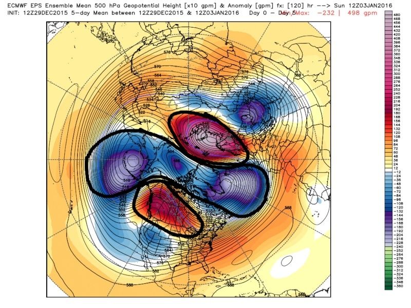
This is not a shock if you read my latest Mo Mo, where I posted this image showing exactly what the Ensembles are showing.
There is a strong upper level energy breaking off the Siberian PV and working it's way into the SW CONUS to bring about a -PNA. As noted in the blog, this is part of the pattern transition. The -EPO/-AO is establishing itself over Canada and the Arctic. The Aleutian trough won't become better defined or organized until the EPO ridge retrogrades more into Alaska. This is where we need the Stratosphere to come in. If there's a Strat PV split, the Siberian vortex should break down or turn into an anomalous Aleutian trough. Thus, the first 10-12 days of January should average out to nornal. There will be some cold and mild days.
I still expect a pattern change to colder than normal weather to occur between January 12th and 15th, with a full scale pattern change involving the Stratosphere around January 20th-24th.
What I'm seeing in the LR is to be expected. No surprises.
P.S. - post was more directed to Al. Scott sees the pattern well.
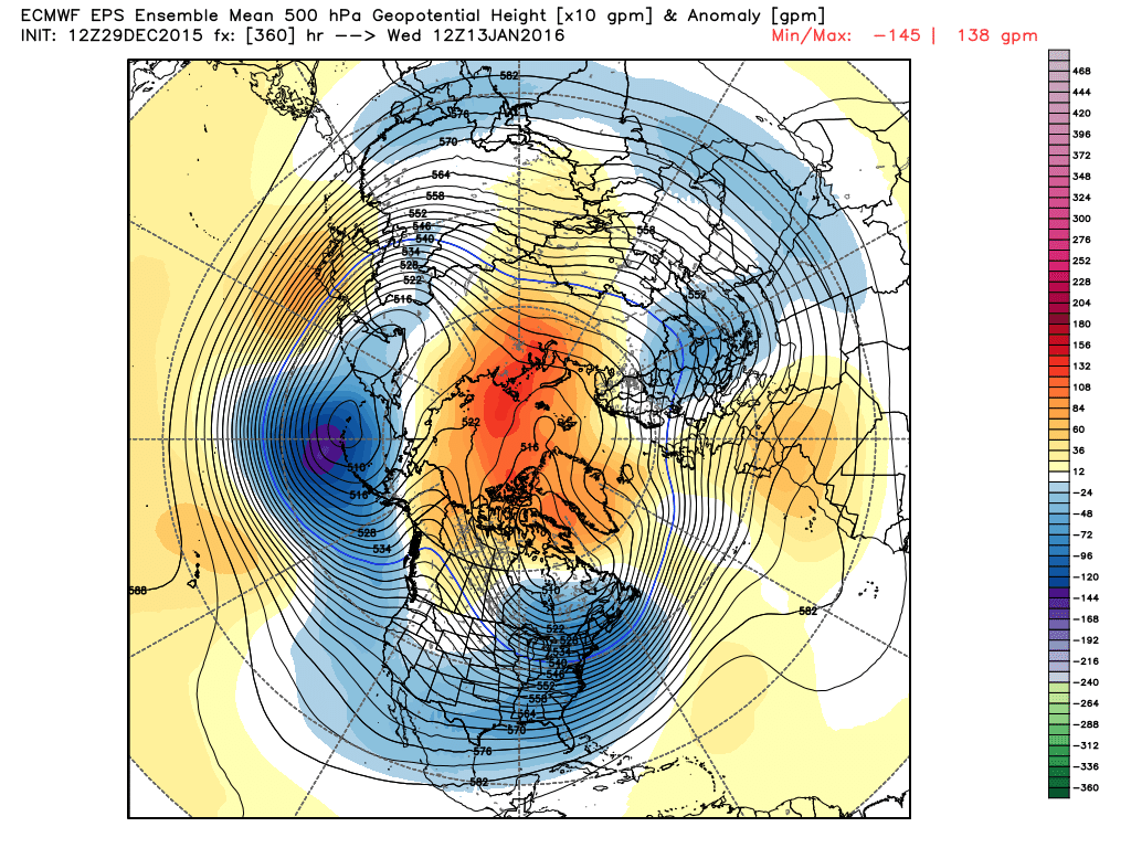
To build off this post, look what the ECM Ensembles do in the long range. Almost exactly what I said. The Siberian Vortex turns into an organized and we'll defined Aleutian trough. You're not see a -PNA in this time frame. TEXTBOOK AND GORGEOUS
_________________
_______________________________________________________________________________________________________
CLICK HERE to view NJ Strong Snowstorm Classifications
Frank_Wx- Godzilla Seeker
- Posts : 21305
Reputation : 328
Join date : 2013-01-05
Age : 31
Location : Jersey City, NJ -
Page 34 of 40 • 1 ... 18 ... 33, 34, 35 ... 40 ![]()
|
|
|