
 Search
Long Range Thread 9.0
Page 35 of 40 •  1 ... 19 ... 34, 35, 36 ... 40
 ![]()
Re: Long Range Thread 9.0
![]() by CPcantmeasuresnow Tue Dec 29, 2015 6:30 pm
by CPcantmeasuresnow Tue Dec 29, 2015 6:30 pm
chief7 wrote:Another plus for the cold air that is coming, natural gas for February delivery is up 37% in the last 8 days in heavy trading in a time of year when we don't really see heavy trading a quote from another board
Hey Docstox!!!!
How about a warning next time. I could have joined you in retirement.
CPcantmeasuresnow- Wx Statistician Guru

- Posts : 7274
Join date : 2013-01-07
Re: Long Range Thread 9.0
![]() by Frank_Wx Tue Dec 29, 2015 7:10 pm
by Frank_Wx Tue Dec 29, 2015 7:10 pm
Frank_Wx wrote:sroc4 wrote:algae888 wrote:7-10 ensemble mean. looks like current pattern. at least the ridge over the n/e...
HUGE difference compared to current pattern Al. Look at the red over the arctic. That tells you that the ridge you see in the NE is transient. Not going to last,maybe 24-36hrs. Will likely trend colder over time because another cold Canadian HP is set to drop into the conus right after. I explain it in a little more detail in my post above.
This is not a shock if you read my latest Mo Mo, where I posted this image showing exactly what the Ensembles are showing.
There is a strong upper level energy breaking off the Siberian PV and working it's way into the SW CONUS to bring about a -PNA. As noted in the blog, this is part of the pattern transition. The -EPO/-AO is establishing itself over Canada and the Arctic. The Aleutian trough won't become better defined or organized until the EPO ridge retrogrades more into Alaska. This is where we need the Stratosphere to come in. If there's a Strat PV split, the Siberian vortex should break down or turn into an anomalous Aleutian trough. Thus, the first 10-12 days of January should average out to nornal. There will be some cold and mild days.
I still expect a pattern change to colder than normal weather to occur between January 12th and 15th, with a full scale pattern change involving the Stratosphere around January 20th-24th.
What I'm seeing in the LR is to be expected. No surprises.
P.S. - post was more directed to Al. Scott sees the pattern well.

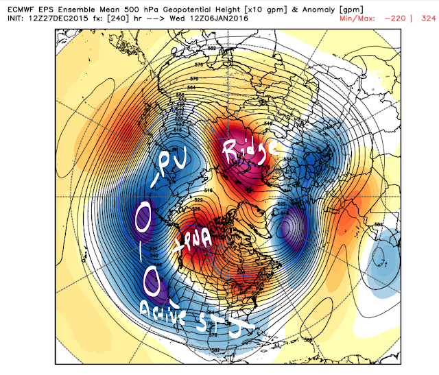
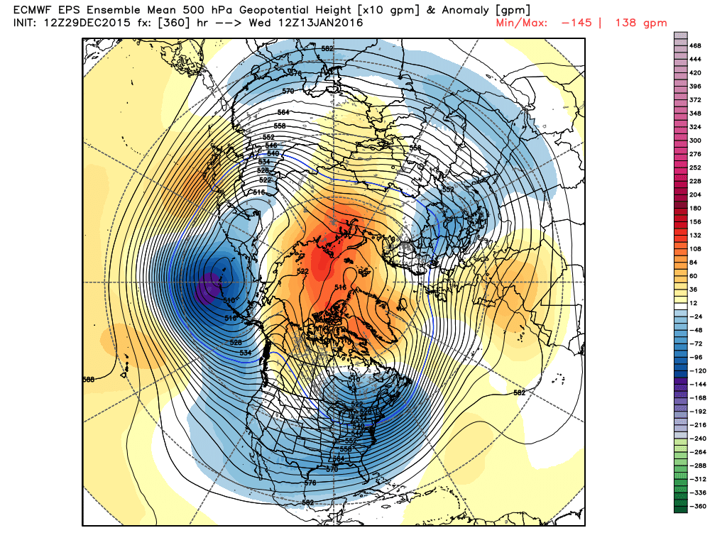
To build off this post, look what the ECM Ensembles do in the long range. Almost exactly what I said. The Siberian Vortex turns into an organized and we'll defined Aleutian trough. You're not see a -PNA in this time frame. TEXTBOOK AND GORGEOUS
Frank_Wx- Godzilla Seeker

- Posts : 21305
Join date : 2013-01-05 -

Re: Long Range Thread 9.0
![]() by amugs Tue Dec 29, 2015 8:39 pm
by amugs Tue Dec 29, 2015 8:39 pm
skinsfan1177 wrote:amugs wrote:Good discussion, Al the pattern change is coming Euro Para is going to school the model means. There will be chances for storms - the AL Low slides SSW of the Aleutians and that will help pump the ridge on the West coast opening up the STJ to travel in a ENE direction across the southernmost tier of America. -AO sitting in Hudson Bay not in the GL if so we need a lot of chap stick and Vaseline but that doesn't look to happen. Lets get the cold air first and then we get the storms and Mr.Cohen should help with his latest write up:
http://www.aer.com/science-research/climate-weather/arctic-oscillation
Amugs when do think in your opinion we see the white gold?
Skins,
I am thinking around the 8thish of Jan. May see a clipper slide through or we can get a very organized and significant storm according to the Euro Para Ens run. May be two during the time frame from the 8th to 14th. Models will not pick up on this storm until the medium range with the dynamics at work. From what I have read the models have issues picking this up in LR whi ch is fine by me.
Frank that is just a gorgeous map u posted. Stormd galore as the stj slides under the ridge, this is what I have been HARPING on since August when the euro ens monthlys came out
_________________
Mugs
AKA:King: Snow Weenie
Self Proclaimed
WINTER 2014-15 : 55.12" +.02 for 6 coatings (avg. 35")
WINTER 2015-16 Total - 29.8" (Avg 35")
WINTER 2016-17 : 39.5" so far

amugs- Advanced Forecaster - Mod

- Posts : 15093
Reputation : 213
Join date : 2013-01-07
Age : 54
Location : Hillsdale,NJ
Re: Long Range Thread 9.0
![]() by amugs Tue Dec 29, 2015 10:29 pm
by amugs Tue Dec 29, 2015 10:29 pm
.png)
_________________
Mugs
AKA:King: Snow Weenie
Self Proclaimed
WINTER 2014-15 : 55.12" +.02 for 6 coatings (avg. 35")
WINTER 2015-16 Total - 29.8" (Avg 35")
WINTER 2016-17 : 39.5" so far
amugs- Advanced Forecaster - Mod
- Posts : 15093
Reputation : 213
Join date : 2013-01-07
Age : 54
Location : Hillsdale,NJ
Re: Long Range Thread 9.0
![]() by amugs Tue Dec 29, 2015 10:56 pm
by amugs Tue Dec 29, 2015 10:56 pm
https://www.nymetroweather.com/2015/12/29/warmth-on-borrowed-time-as-january-pa/
_________________
Mugs
AKA:King: Snow Weenie
Self Proclaimed
WINTER 2014-15 : 55.12" +.02 for 6 coatings (avg. 35")
WINTER 2015-16 Total - 29.8" (Avg 35")
WINTER 2016-17 : 39.5" so far
amugs- Advanced Forecaster - Mod
- Posts : 15093
Reputation : 213
Join date : 2013-01-07
Age : 54
Location : Hillsdale,NJ
Re: Long Range Thread 9.0
![]() by Snow88 Wed Dec 30, 2015 12:13 am
by Snow88 Wed Dec 30, 2015 12:13 am


Snow88- Senior Enthusiast

- Posts : 2193
Reputation : 4
Join date : 2013-01-09
Age : 35
Location : Brooklyn, NY
Re: Long Range Thread 9.0
![]() by NjWeatherGuy Wed Dec 30, 2015 1:03 am
by NjWeatherGuy Wed Dec 30, 2015 1:03 am
http://mag.ncep.noaa.gov/Image.php?fhr=288&image=data%2Fgfs%2F00%2Fgfs_namer_288_10m_wnd_precip.gif&model=gfs&area=namer¶m=10m_wnd_precip&group=Model+Guidance&preselected_formatted_cycle_date=20151230+00+UTC&imageSize=M&ps=model

NjWeatherGuy- Advanced Forecaster

- Posts : 4100
Reputation : 28
Join date : 2013-01-06
Location : Belle Mead, NJ
Re: Long Range Thread 9.0
![]() by devsman Wed Dec 30, 2015 1:53 am
by devsman Wed Dec 30, 2015 1:53 am
NjWeatherGuy wrote:Theres been a storm around the 11th on the GFS for awhile. Fantasy range? Sorta. But something to track... At least for the moment which has me happy but the way this season has gone itll turn into a GLC or a Bermuda storm by 2 days from now...
http://mag.ncep.noaa.gov/Image.php?fhr=288&image=data%2Fgfs%2F00%2Fgfs_namer_288_10m_wnd_precip.gif&model=gfs&area=namer¶m=10m_wnd_precip&group=Model+Guidance&preselected_formatted_cycle_date=20151230+00+UTC&imageSize=M&ps=model
Everytime I see a post like this, I look for Jmans name. Doesn't seem right when he's not the one to post the long range threats, lol

devsman- Pro Enthusiast

- Posts : 424
Reputation : 4
Join date : 2014-01-01
Age : 48
Location : merrick, ny (south shore of Long Island)
Re: Long Range Thread 9.0
![]() by NjWeatherGuy Wed Dec 30, 2015 2:55 am
by NjWeatherGuy Wed Dec 30, 2015 2:55 am
NjWeatherGuy- Advanced Forecaster
- Posts : 4100
Reputation : 28
Join date : 2013-01-06
Location : Belle Mead, NJ
Re: Long Range Thread 9.0
![]() by NjWeatherGuy Wed Dec 30, 2015 2:59 am
by NjWeatherGuy Wed Dec 30, 2015 2:59 am
http://meteocentre.com/models/explorateur.php?lang=en&map=na&run=00&mod=gemglb&stn=PNMPR&comp=1&run2=00&mod2=gemglb&stn2=PNMPR&hh2=000&fixhh=1&stn2_type=prog&mode=latest&yyyy=latest&mm=latest&dd=latest&hh=240
NjWeatherGuy- Advanced Forecaster
- Posts : 4100
Reputation : 28
Join date : 2013-01-06
Location : Belle Mead, NJ
Re: Long Range Thread 9.0
![]() by NjWeatherGuy Wed Dec 30, 2015 3:04 am
by NjWeatherGuy Wed Dec 30, 2015 3:04 am
NjWeatherGuy- Advanced Forecaster
- Posts : 4100
Reputation : 28
Join date : 2013-01-06
Location : Belle Mead, NJ
Re: Long Range Thread 9.0
![]() by NjWeatherGuy Wed Dec 30, 2015 6:45 am
by NjWeatherGuy Wed Dec 30, 2015 6:45 am
http://mag.ncep.noaa.gov/Image.php?fhr=219&image=data%2Fgfs%2F06%2Fgfs_namer_219_850_temp_mslp_precip.gif&model=gfs&area=namer¶m=850_temp_mslp_precip&group=Model+Guidance&preselected_formatted_cycle_date=20151230+06+UTC&imageSize=M&ps=model
NjWeatherGuy- Advanced Forecaster
- Posts : 4100
Reputation : 28
Join date : 2013-01-06
Location : Belle Mead, NJ
Re: Long Range Thread 9.0
![]() by jmanley32 Wed Dec 30, 2015 8:50 am
by jmanley32 Wed Dec 30, 2015 8:50 am

jmanley32- Senior Enthusiast
- Posts : 20513
Reputation : 108
Join date : 2013-12-12
Age : 42
Location : Yonkers, NY
Re: Long Range Thread 9.0
![]() by jmanley32 Wed Dec 30, 2015 8:54 am
by jmanley32 Wed Dec 30, 2015 8:54 am
NjWeatherGuy wrote:I dont take them seriously. Just like to see the signal because 9/10 times when theres consistently a storm popping up there when the time comes there will be a storm somewhere, could it be 1000mi off? Yes.
Or it could be 1000 miles wide snowstorm like sandy was size wise, then you wouldn't be off at all.
jmanley32- Senior Enthusiast
- Posts : 20513
Reputation : 108
Join date : 2013-12-12
Age : 42
Location : Yonkers, NY
Re: Long Range Thread 9.0
![]() by amugs Wed Dec 30, 2015 10:12 am
by amugs Wed Dec 30, 2015 10:12 am
_________________
Mugs
AKA:King: Snow Weenie
Self Proclaimed
WINTER 2014-15 : 55.12" +.02 for 6 coatings (avg. 35")
WINTER 2015-16 Total - 29.8" (Avg 35")
WINTER 2016-17 : 39.5" so far
amugs- Advanced Forecaster - Mod
- Posts : 15093
Reputation : 213
Join date : 2013-01-07
Age : 54
Location : Hillsdale,NJ
Re: Long Range Thread 9.0
![]() by skinsfan1177 Wed Dec 30, 2015 10:42 am
by skinsfan1177 Wed Dec 30, 2015 10:42 am
amugs wrote:Hey skins what did I said yesterday when you asked when the first snowfall would be?? Jan 8ish. Looking pretty good as per the 0Z and 6Z runs. Still lots of time but as one can see teh ST]J is going to open up due to the Ridge relaxing on the EC (moving up and out) and the PNA going Positive along with the EPO going Neg (PAC block)
I hope so Amugs your right on. Couple questions do we know as far as how cold will get and in LR Are a lot of storms popping up?

skinsfan1177- Senior Enthusiast
- Posts : 4485
Reputation : 35
Join date : 2013-01-07
Age : 46
Location : Point Pleasant Boro
Re: Long Range Thread 9.0
![]() by amugs Wed Dec 30, 2015 12:23 pm
by amugs Wed Dec 30, 2015 12:23 pm
skinsfan1177 wrote:amugs wrote:Hey skins what did I said yesterday when you asked when the first snowfall would be?? Jan 8ish. Looking pretty good as per the 0Z and 6Z runs. Still lots of time but as one can see teh ST]J is going to open up due to the Ridge relaxing on the EC (moving up and out) and the PNA going Positive along with the EPO going Neg (PAC block)
A lot is 6 for Jman and 3 for Dunzoo, so it is all relative. Once we stables the pattern after a long pm with my ex students who are pro mets and Isotherm, if things set up properly then we could see a 30 to 50 day period of winter that may rival 201-11 and 2009-10. But as we get closer to the pattern change by the 10th ish I believe we see storms starting to pop and it will happen when the epo and pna set ip the pac block.
I hope so Amugs your right on. Couple questions do we know as far as how cold will get and in LR Are a lot of storms popping up?
_________________
Mugs
AKA:King: Snow Weenie
Self Proclaimed
WINTER 2014-15 : 55.12" +.02 for 6 coatings (avg. 35")
WINTER 2015-16 Total - 29.8" (Avg 35")
WINTER 2016-17 : 39.5" so far
amugs- Advanced Forecaster - Mod
- Posts : 15093
Reputation : 213
Join date : 2013-01-07
Age : 54
Location : Hillsdale,NJ
Re: Long Range Thread 9.0
![]() by algae888 Wed Dec 30, 2015 12:39 pm
by algae888 Wed Dec 30, 2015 12:39 pm

algae888- Advanced Forecaster
- Posts : 5311
Reputation : 46
Join date : 2013-02-05
Age : 61
Location : mt. vernon, new york
Re: Long Range Thread 9.0
![]() by algae888 Wed Dec 30, 2015 2:07 pm
by algae888 Wed Dec 30, 2015 2:07 pm
algae888- Advanced Forecaster
- Posts : 5311
Reputation : 46
Join date : 2013-02-05
Age : 61
Location : mt. vernon, new york
Re: Long Range Thread 9.0
![]() by jmanley32 Wed Dec 30, 2015 2:20 pm
by jmanley32 Wed Dec 30, 2015 2:20 pm
jmanley32- Senior Enthusiast
- Posts : 20513
Reputation : 108
Join date : 2013-12-12
Age : 42
Location : Yonkers, NY
Re: Long Range Thread 9.0
![]() by algae888 Wed Dec 30, 2015 2:27 pm
by algae888 Wed Dec 30, 2015 2:27 pm
Yes J man the storms in the next 7 days are all going to be out to sea as we have no blocking. The one that I'm referring to that looks like it wants to phase would be day 10 on the Euro operational. It's a good thing to have the systems coming to Southern California especially if we get the blocking that so well modeled right now. They shouldn't cut and have a chance to come up the coast if the NAO goes negativejmanley32 wrote:Yeah but they all well offshore, suppressed? GFS has a double barrel low that's interesting.
algae888- Advanced Forecaster
- Posts : 5311
Reputation : 46
Join date : 2013-02-05
Age : 61
Location : mt. vernon, new york
Re: Long Range Thread 9.0
![]() by amugs Wed Dec 30, 2015 2:44 pm
by amugs Wed Dec 30, 2015 2:44 pm
.gif)
_________________
Mugs
AKA:King: Snow Weenie
Self Proclaimed
WINTER 2014-15 : 55.12" +.02 for 6 coatings (avg. 35")
WINTER 2015-16 Total - 29.8" (Avg 35")
WINTER 2016-17 : 39.5" so far
amugs- Advanced Forecaster - Mod
- Posts : 15093
Reputation : 213
Join date : 2013-01-07
Age : 54
Location : Hillsdale,NJ
Re: Long Range Thread 9.0
![]() by sroc4 Wed Dec 30, 2015 2:52 pm
by sroc4 Wed Dec 30, 2015 2:52 pm
amugs wrote:Look at the EURI AP ( Austin Powers) MJO FORECAST is this nice or what?
I had an amazing write up this morning regarding the MJO and current observations, and how we are right on track. There were beuatiful graphics and maps to support my thoughts. I was an hr into my write up when I clicked the wrong button and lost it all!!!!!! I was so pissed. I may try and write it up again tonight or tomorrow morning. It was a keeper. End rant Yes Loving that MJO forecast
_________________
"In weather and in life, there's no winning and losing; there's only winning and learning."
WINTER 2012/2013 TOTALS 43.65"WINTER 2017/2018 TOTALS 62.85" WINTER 2022/2023 TOTALS 4.9"
WINTER 2013/2014 TOTALS 64.85"WINTER 2018/2019 TOTALS 14.25" WINTER 2023/2024 TOTALS 13.1"
WINTER 2014/2015 TOTALS 71.20"WINTER 2019/2020 TOTALS 6.35"
WINTER 2015/2016 TOTALS 35.00"WINTER 2020/2021 TOTALS 37.75"
WINTER 2016/2017 TOTALS 42.25"WINTER 2021/2022 TOTALS 31.65"

sroc4- Admin
- Posts : 8331
Reputation : 301
Join date : 2013-01-07
Location : Wading River, LI
Re: Long Range Thread 9.0
![]() by CPcantmeasuresnow Wed Dec 30, 2015 3:19 pm
by CPcantmeasuresnow Wed Dec 30, 2015 3:19 pm
sroc4 wrote:amugs wrote:Look at the EURI AP ( Austin Powers) MJO FORECAST is this nice or what?
I had an amazing write up this morning regarding the MJO and current observations, and how we are right on track. There were beuatiful graphics and maps to support my thoughts. I was an hr into my write up when I clicked the wrong button and lost it all!!!!!! I was so pissed. I may try and write it up again tonight or tomorrow morning. It was a keeper. End rant Yes Loving that MJO forecast
Ouch.
Been there done that. Excruciating when it happens.

CPcantmeasuresnow- Wx Statistician Guru
- Posts : 7274
Reputation : 230
Join date : 2013-01-07
Age : 103
Location : Eastern Orange County, NY
Re: Long Range Thread 9.0
![]() by skinsfan1177 Wed Dec 30, 2015 4:07 pm
by skinsfan1177 Wed Dec 30, 2015 4:07 pm
skinsfan1177- Senior Enthusiast
- Posts : 4485
Reputation : 35
Join date : 2013-01-07
Age : 46
Location : Point Pleasant Boro
Re: Long Range Thread 9.0
![]() by Frank_Wx Wed Dec 30, 2015 6:02 pm
by Frank_Wx Wed Dec 30, 2015 6:02 pm
sroc4 wrote:amugs wrote:Look at the EURI AP ( Austin Powers) MJO FORECAST is this nice or what?
I had an amazing write up this morning regarding the MJO and current observations, and how we are right on track. There were beuatiful graphics and maps to support my thoughts. I was an hr into my write up when I clicked the wrong button and lost it all!!!!!! I was so pissed. I may try and write it up again tonight or tomorrow morning. It was a keeper. End rant Yes Loving that MJO forecast
I did that once. It ruined my week.
_________________
_______________________________________________________________________________________________________
CLICK HERE to view NJ Strong Snowstorm Classifications

Frank_Wx- Godzilla Seeker
- Posts : 21305
Reputation : 328
Join date : 2013-01-05
Age : 31
Location : Jersey City, NJ -
Re: Long Range Thread 9.0
![]() by algae888 Wed Dec 30, 2015 6:19 pm
by algae888 Wed Dec 30, 2015 6:19 pm

eps goes from this
.thumb.jpg.4cfa0db37fbb1be17ee9041ef6d60dd7.jpg)
to this hrs 240-288. -epo +pna stj aimed right at us.
algae888- Advanced Forecaster
- Posts : 5311
Reputation : 46
Join date : 2013-02-05
Age : 61
Location : mt. vernon, new york
Page 35 of 40 • 1 ... 19 ... 34, 35, 36 ... 40 ![]()
|
|
|