
 Search
Long Range Thread 9.0
Page 19 of 40 •  1 ... 11 ... 18, 19, 20 ... 29 ... 40
 ![]()
Re: Long Range Thread 9.0
![]() by sroc4 Sun Dec 13, 2015 10:55 am
by sroc4 Sun Dec 13, 2015 10:55 am
"It goes without saying that many who wish for "real winter weather" in the United States are deeply troubled by the very warm December temperatures so far. Many unfairly are pointing fingers at the El Nino episode, which actually is not behaving according to synoptic climatology for such events. The Pacific Northwest continues to see excessive precipitation, while California and Florida have largely missed out on the excessive rainfall cases seen in 1982-83 and 1997-98, the previous periods that featured a very high-end +ENSO signal.
The polar westerlies remain unified, and dominant, which is much more like what should occur in a well-defined "La Nina" influenced pattern in the colder months over North America. Curiously, conditions across Eurasia are performing fairly close to weather that transpires with an El Nino (split flow, colder northern third with occasional spillages of cPk and cA regimes into the Middle East and Indus Valley).
So the operative question that is bandied about: are we really going to miss winter this time around? Has "global warming" conspired with the "Super El Nino" to chase away Santa for snow lovers in the U.S. The answer is no, Virginia! The warm December was forecast well by the analog method used here (no snow in Buffalo, and in fact total lack of ice over the entire Great Lakes). And there are very valid reasons for a "for real" change in the jet stream configuration across the entire continent once we move deeper into January.
First of all, I should clarify what I think is causing the display of mild temperatures and the unusual array of precipitation in the lower 48 states. It is not El Nino. Rather, the dominant driver in this configuration is the immense circumpolar vortex (see 10MB temperature forecasts), which has fairly evenly covered the Arctic Circle up to this point after congealing in October. This +AO phase is impressive, no doubt. Such a strong cAk gyre blots out any and all chances for lasting blocking ridge formation above 50 N Latitude. But research on the subject shows that long-lived and intense circulations straddling the North Pole cannot go on forever. And I suspect that cracks in the vortex will show up soon, given what the numerical models are projecting as a shift in the skew of the frigid circulation toward northern Europe and western Russia.
Another factor to consider is the very warm oceanic sea surface temperatures. It is not just the El Nino signal; check out the Atlantic Basin (excepting near the Grand Banks/Flemish Cap) and the entirety of the Pacific and Indian Oceans. The atmosphere has been responding by moderating its boundary layer readings. But with a low sun angle and increasing snowpack in the Northern Hemisphere, something has got to give. With the aforementioned stratospheric warming in the western third of North America, and the still vigorous subtropical jet stream crossing Mexico into the Old South (forced there by the anomalous Southeast heat ridge), a mean 500MB trough should start to form between the Rocky Mountains and Appalachia during the first week of January. It continues to be my thinking that a +PNA/-AO configuration will take shape next month, with the risk of major storms tracking along the Gulf Coast and then up along or off the Eastern Seaboard. That means drainage of air from Canada and the snowpack which is expanding across our northern neighbor.
Until that time, I can assure you that the 11 - 15 day period, and probably most of the 16 - 20 day range, will again be a cold/cool West vs. mild/warm East alignment. Storms should still roll through the Pacific Northwest into the lower High Plains, than recurve into Michigan and Ontario. A key flashpoint in the last week of December and first week of January is snow cover in the Upper Midwest and Great Lakes. If we indeed are going to see a colder turn in the New Year, Minnesota, Wisconsin and the MI Upper Peninsula will see more of the white stuff as we greet 2016.
Winter is not over yet, gang. We've only just begun.
sroc4- Admin

- Posts : 8331
Join date : 2013-01-07
Re: Long Range Thread 9.0
![]() by Frank_Wx Sun Dec 13, 2015 11:16 am
by Frank_Wx Sun Dec 13, 2015 11:16 am
Frank_Wx- Godzilla Seeker
- Posts : 21305
Join date : 2013-01-05 -

Re: Long Range Thread 9.0
![]() by amugs Sun Dec 13, 2015 1:04 pm
by amugs Sun Dec 13, 2015 1:04 pm
November 30th

Dec 12th - my my what a frickin change a good look - heights protract W and N and allow the colder air to cut underneath it to the coast for Jan - happening faster than some think

_________________
Mugs
AKA:King: Snow Weenie
Self Proclaimed
WINTER 2014-15 : 55.12" +.02 for 6 coatings (avg. 35")
WINTER 2015-16 Total - 29.8" (Avg 35")
WINTER 2016-17 : 39.5" so far

amugs- Advanced Forecaster - Mod

- Posts : 15093
Reputation : 213
Join date : 2013-01-07
Age : 54
Location : Hillsdale,NJ
Re: Long Range Thread 9.0
![]() by sroc4 Sun Dec 13, 2015 1:43 pm
by sroc4 Sun Dec 13, 2015 1:43 pm
Frank_Wx wrote:Nice read. He brings up a great point - our atmosphere is not responding to El Nino. The STJ is displaced north into the central and northern Pacific. Storm systems effecting Pac NW should realistically be tracking into southern California during an El Nino. Additionally, the MJO has been very active the last several weeks. If you research the MJO during El Nino years, it's shown to be in the COD. In sum, the MJO and Stratosphere are the main drivers behind our current pattern and the El Nino acts more as an enhancement. So yea, def agree with Larry with this. Though I do feel the very strong 200-300mb jet streaks crashing into the western US have something to do with the intensity of El Nino.
I think the STJ is being shunted south actually into the Mexico and into the "Old south" region. The NW is being inundated via the Pac Jet.
 " />
" />_________________
"In weather and in life, there's no winning and losing; there's only winning and learning."
WINTER 2012/2013 TOTALS 43.65"WINTER 2017/2018 TOTALS 62.85" WINTER 2022/2023 TOTALS 4.9"
WINTER 2013/2014 TOTALS 64.85"WINTER 2018/2019 TOTALS 14.25" WINTER 2023/2024 TOTALS 13.1"
WINTER 2014/2015 TOTALS 71.20"WINTER 2019/2020 TOTALS 6.35"
WINTER 2015/2016 TOTALS 35.00"WINTER 2020/2021 TOTALS 37.75"
WINTER 2016/2017 TOTALS 42.25"WINTER 2021/2022 TOTALS 31.65"

sroc4- Admin
- Posts : 8331
Reputation : 301
Join date : 2013-01-07
Location : Wading River, LI
Re: Long Range Thread 9.0
![]() by algae888 Mon Dec 14, 2015 9:29 am
by algae888 Mon Dec 14, 2015 9:29 am

algae888- Advanced Forecaster

- Posts : 5311
Reputation : 46
Join date : 2013-02-05
Age : 61
Location : mt. vernon, new york
Re: Long Range Thread 9.0
![]() by dkodgis Mon Dec 14, 2015 9:38 am
by dkodgis Mon Dec 14, 2015 9:38 am

dkodgis- Senior Enthusiast

- Posts : 2495
Reputation : 98
Join date : 2013-12-29
Re: Long Range Thread 9.0
![]() by skinsfan1177 Mon Dec 14, 2015 9:58 am
by skinsfan1177 Mon Dec 14, 2015 9:58 am
dkodgis wrote:Yesterday, I checked the temps at around 7 pm on my iPhone and for Seville Spain, Tokyo Japan, Glenmore PA, Wallkill, NYC...all said 54 degrees. I have friends in these places and I live in Wallkill; maybe even the weather widget for the iPhone is getting confused and there is a tech problem. It seems too convenient that the same temps are found in these places across the planet. I still have roses on one bush and I had to cut the grass again yesterday. I wonder what Spring 2016 will be: very dry? What happens in the spring in the NE after a strong El Nino?
That's crazy. My wife's family lives in wallkill and pine bush by. We will be heading that way for the holidays

skinsfan1177- Senior Enthusiast
- Posts : 4485
Reputation : 35
Join date : 2013-01-07
Age : 46
Location : Point Pleasant Boro
Re: Long Range Thread 9.0
![]() by Quietace Mon Dec 14, 2015 10:11 am
by Quietace Mon Dec 14, 2015 10:11 am
You are correct. You can clearly see the STJ ejecting out of the ITCZ as you pointed out. Though thats not to say some tropical convection that originated from the STJ ejected into a mid latitude cyclone giving the PAC Jet similar Precip Water Values; hence similar moisture characteristics.sroc4 wrote:Frank_Wx wrote:Nice read. He brings up a great point - our atmosphere is not responding to El Nino. The STJ is displaced north into the central and northern Pacific. Storm systems effecting Pac NW should realistically be tracking into southern California during an El Nino. Additionally, the MJO has been very active the last several weeks. If you research the MJO during El Nino years, it's shown to be in the COD. In sum, the MJO and Stratosphere are the main drivers behind our current pattern and the El Nino acts more as an enhancement. So yea, def agree with Larry with this. Though I do feel the very strong 200-300mb jet streaks crashing into the western US have something to do with the intensity of El Nino.
I think the STJ is being shunted south actually into the Mexico and into the "Old south" region. The NW is being inundated via the Pac Jet.

Quietace- Meteorologist - Mod

- Posts : 3687
Reputation : 33
Join date : 2013-01-07
Age : 27
Location : Point Pleasant, NJ
Re: Long Range Thread 9.0
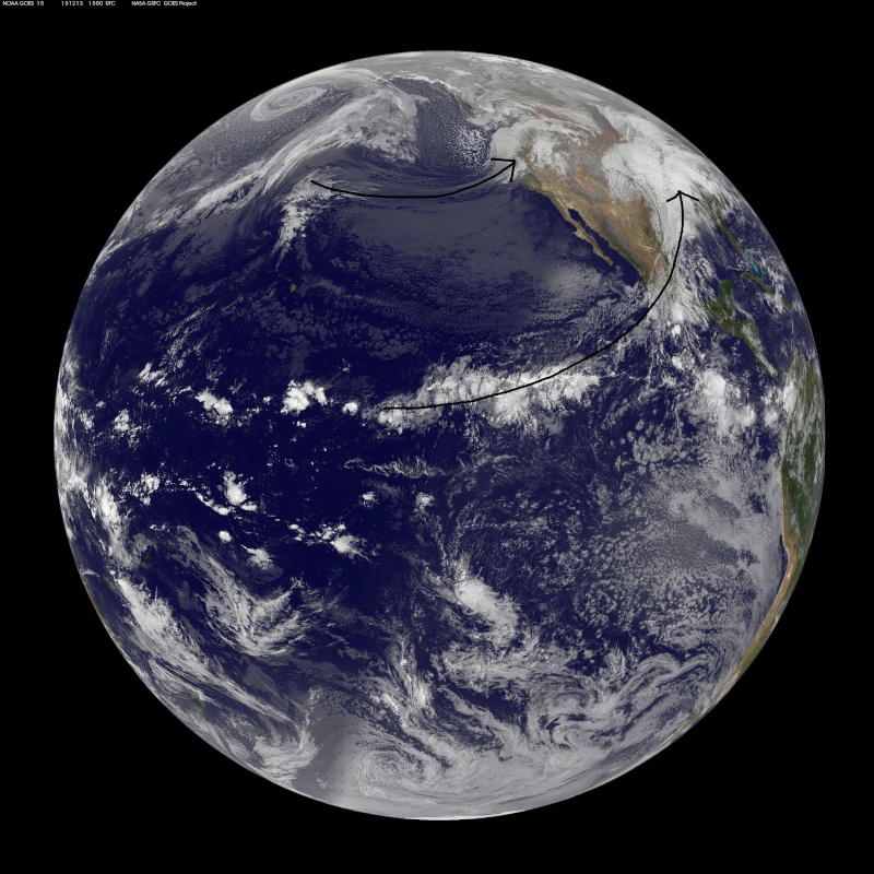
![]() by docstox12 Mon Dec 14, 2015 10:25 am
by docstox12 Mon Dec 14, 2015 10:25 am
sroc4 wrote:Frank_Wx wrote:Nice read. He brings up a great point - our atmosphere is not responding to El Nino. The STJ is displaced north into the central and northern Pacific. Storm systems effecting Pac NW should realistically be tracking into southern California during an El Nino. Additionally, the MJO has been very active the last several weeks. If you research the MJO during El Nino years, it's shown to be in the COD. In sum, the MJO and Stratosphere are the main drivers behind our current pattern and the El Nino acts more as an enhancement. So yea, def agree with Larry with this. Though I do feel the very strong 200-300mb jet streaks crashing into the western US have something to do with the intensity of El Nino.
I think the STJ is being shunted south actually into the Mexico and into the "Old south" region. The NW is being inundated via the Pac Jet.
That is just an incredible image Doc.Amazing!!!

docstox12- Wx Statistician Guru

- Posts : 8502
Reputation : 222
Join date : 2013-01-07
Age : 73
Location : Monroe NY
Re: Long Range Thread 9.0
![]() by amugs Mon Dec 14, 2015 11:02 am
by amugs Mon Dec 14, 2015 11:02 am

_________________
Mugs
AKA:King: Snow Weenie
Self Proclaimed
WINTER 2014-15 : 55.12" +.02 for 6 coatings (avg. 35")
WINTER 2015-16 Total - 29.8" (Avg 35")
WINTER 2016-17 : 39.5" so far
amugs- Advanced Forecaster - Mod
- Posts : 15093
Reputation : 213
Join date : 2013-01-07
Age : 54
Location : Hillsdale,NJ
Re: Long Range Thread 9.0
![]() by Quietace Mon Dec 14, 2015 11:12 am
by Quietace Mon Dec 14, 2015 11:12 am
Warm and Wet with the position of that ridge.amugs wrote:This is just brutal - my god we'll finish December +12 with this = blow away any record in recent history!!!
Quietace- Meteorologist - Mod
- Posts : 3687
Reputation : 33
Join date : 2013-01-07
Age : 27
Location : Point Pleasant, NJ
Re: Long Range Thread 9.0
![]() by CPcantmeasuresnow Mon Dec 14, 2015 1:06 pm
by CPcantmeasuresnow Mon Dec 14, 2015 1:06 pm
amugs wrote:This is just brutal - my god we'll finish December +12 with this = blow away any record in recent history!!!
This December may break the record for the greatest warm temperature deviation from average we have ever seen in any month. Al mentioned this in an earlier post and I agree.
I was hoping that after the warmest autumn in history in these parts that things might finally turn, in realty they have gotten much worse, at least for the short and mid term.

CPcantmeasuresnow- Wx Statistician Guru
- Posts : 7274
Reputation : 230
Join date : 2013-01-07
Age : 103
Location : Eastern Orange County, NY
Re: Long Range Thread 9.0
![]() by amugs Mon Dec 14, 2015 1:25 pm
by amugs Mon Dec 14, 2015 1:25 pm

Bastan get crushed of course

_________________
Mugs
AKA:King: Snow Weenie
Self Proclaimed
WINTER 2014-15 : 55.12" +.02 for 6 coatings (avg. 35")
WINTER 2015-16 Total - 29.8" (Avg 35")
WINTER 2016-17 : 39.5" so far
amugs- Advanced Forecaster - Mod
- Posts : 15093
Reputation : 213
Join date : 2013-01-07
Age : 54
Location : Hillsdale,NJ
Re: Long Range Thread 9.0
![]() by Snow88 Mon Dec 14, 2015 2:02 pm
by Snow88 Mon Dec 14, 2015 2:02 pm

Snow88- Senior Enthusiast
- Posts : 2193
Reputation : 4
Join date : 2013-01-09
Age : 35
Location : Brooklyn, NY
Re: Long Range Thread 9.0
![]() by amugs Mon Dec 14, 2015 2:10 pm
by amugs Mon Dec 14, 2015 2:10 pm
Snow88 wrote:^^ I will just be happy with snow flakes lol
Me too!!!!!!!!!!!!
_________________
Mugs
AKA:King: Snow Weenie
Self Proclaimed
WINTER 2014-15 : 55.12" +.02 for 6 coatings (avg. 35")
WINTER 2015-16 Total - 29.8" (Avg 35")
WINTER 2016-17 : 39.5" so far
amugs- Advanced Forecaster - Mod
- Posts : 15093
Reputation : 213
Join date : 2013-01-07
Age : 54
Location : Hillsdale,NJ
Re: Long Range Thread 9.0
![]() by Snow88 Mon Dec 14, 2015 2:21 pm
by Snow88 Mon Dec 14, 2015 2:21 pm
Snow88- Senior Enthusiast
- Posts : 2193
Reputation : 4
Join date : 2013-01-09
Age : 35
Location : Brooklyn, NY
Re: Long Range Thread 9.0
![]() by NjWeatherGuy Mon Dec 14, 2015 2:25 pm
by NjWeatherGuy Mon Dec 14, 2015 2:25 pm

NjWeatherGuy- Advanced Forecaster
- Posts : 4100
Reputation : 28
Join date : 2013-01-06
Location : Belle Mead, NJ
Re: Long Range Thread 9.0
![]() by HectorO Mon Dec 14, 2015 2:26 pm
by HectorO Mon Dec 14, 2015 2:26 pm

HectorO- Pro Enthusiast

- Posts : 959
Reputation : 27
Join date : 2013-01-11
Re: Long Range Thread 9.0
![]() by Guest Mon Dec 14, 2015 4:06 pm
by Guest Mon Dec 14, 2015 4:06 pm
HectorO wrote:Is it time for the "As December goes" thread?
Good one. Brings back memories!!!
Guest- Guest
Re: Long Range Thread 9.0
![]() by Snow88 Mon Dec 14, 2015 4:13 pm
by Snow88 Mon Dec 14, 2015 4:13 pm
Snow88- Senior Enthusiast
- Posts : 2193
Reputation : 4
Join date : 2013-01-09
Age : 35
Location : Brooklyn, NY
Re: Long Range Thread 9.0
![]() by amugs Mon Dec 14, 2015 5:15 pm
by amugs Mon Dec 14, 2015 5:15 pm

.png.3e4b9c715612a3a40404324c464aaba1.png)

.png.3b63397704c5a5689dd2373d72120622.png)
Could have used this in mid November but we'll take it - peak has been reached and cooling off in a big way in just once week.
_________________
Mugs
AKA:King: Snow Weenie
Self Proclaimed
WINTER 2014-15 : 55.12" +.02 for 6 coatings (avg. 35")
WINTER 2015-16 Total - 29.8" (Avg 35")
WINTER 2016-17 : 39.5" so far
amugs- Advanced Forecaster - Mod
- Posts : 15093
Reputation : 213
Join date : 2013-01-07
Age : 54
Location : Hillsdale,NJ
Re: Long Range Thread 9.0
![]() by amugs Mon Dec 14, 2015 5:26 pm
by amugs Mon Dec 14, 2015 5:26 pm
1.2 3 3.4 4
18NOV2015 23.8 2.1 28.0 3.0 29.7 3.1 30.4 1.8
25NOV2015 24.4 2.4 28.0 3.0 29.6 3.0 30.3 1.8
02DEC2015 24.7 2.4 27.9 2.9 29.5 2.9 30.2 1.7
09DEC2015 24.8 2.3 28.0 2.9 29.4 2.8 30.2 1.7
12-14 2.16 2.65 2.45 1.58
_________________
Mugs
AKA:King: Snow Weenie
Self Proclaimed
WINTER 2014-15 : 55.12" +.02 for 6 coatings (avg. 35")
WINTER 2015-16 Total - 29.8" (Avg 35")
WINTER 2016-17 : 39.5" so far
amugs- Advanced Forecaster - Mod
- Posts : 15093
Reputation : 213
Join date : 2013-01-07
Age : 54
Location : Hillsdale,NJ
Re: Long Range Thread 9.0
![]() by Frank_Wx Mon Dec 14, 2015 9:39 pm
by Frank_Wx Mon Dec 14, 2015 9:39 pm
EURO 1hPa temp & heights day 7:

Now day 10:

Part of this may be due to the subsiding easterlies near the Equator to 20N (blue color). Westerlies are taking over in the upper Stratosphere, albeit not very strong just yet.

EURO 10hPa temp and heights Day 7:

Day 10:

You can almost see the wave 2 influence with ridges forming on both sides of the PV. However, it is not look strong enough at the moment to split the PV. I still think this is pretty unlikely just from what Iv'e been reading about -QBO years. We're banking on a strong wave 1 event to displace the PV out of the Arctic Circle.
What's key is to get the warm temperatures to propagate to the mid and lower levels of the Stratosphere. Despite the stronger wave 1 event compared to late November, it does not look like it's enough to penetrate the mid-levels just yet. 50hPa looks to remain very cold.

Judah Cohen posted this on his Twitter:

In a nutshell, it shows stronger vertical energy transfer of Rosby Waves between the Troposphere and Stratosphere between Dec 20th and 25th. This will should help warm the Arctic and weaken the PV.
Lastly, sunspot activity continues to trend downward. The Sun should not be much of a factor when it comes to Troposphere-Stratosphere interaction.

The trend the last couple of days has been for this wave 1 & 2 attack to get stronger. We'll see if this trend holds in the upcoming days.
_________________
_______________________________________________________________________________________________________
CLICK HERE to view NJ Strong Snowstorm Classifications

Frank_Wx- Godzilla Seeker
- Posts : 21305
Reputation : 328
Join date : 2013-01-05
Age : 31
Location : Jersey City, NJ -
Re: Long Range Thread 9.0
![]() by HectorO Mon Dec 14, 2015 9:43 pm
by HectorO Mon Dec 14, 2015 9:43 pm
HectorO- Pro Enthusiast
- Posts : 959
Reputation : 27
Join date : 2013-01-11
Re: Long Range Thread 9.0
![]() by HectorO Mon Dec 14, 2015 10:12 pm
by HectorO Mon Dec 14, 2015 10:12 pm
HectorO- Pro Enthusiast
- Posts : 959
Reputation : 27
Join date : 2013-01-11
Re: Long Range Thread 9.0
![]() by Frank_Wx Mon Dec 14, 2015 10:24 pm
by Frank_Wx Mon Dec 14, 2015 10:24 pm
"
At AER we have developed a polar vortex model that predicts the strength of the polar vortex one month in advance. As we discussed in the blog last month, the model was predicting the polar vortex to become disturbed the third week of December, which is now being predicted by the weather models. The polar vortex model also predicts a similar perturbing of the stratospheric polar vortex in the first week of January and again an even bigger event the second week of January. In addition, the predicted temperature pattern of cold Siberia and warm western Eurasia is favorable for increased WAFz. Therefore, based on the polar vortex model and the upcoming atmospheric circulation pattern, we are anticipating more upward pulses of WAFz. If our expectations of more upward pulses of WAFz is correct, this should be sufficient to force a sudden stratospheric warming (SSW) sometime in January. One ongoing inhibiting background factor is the westerly phase of the quasi-biennial oscillation (QBO) that favors a strong vortex over a weak vortex. But if our expectations of a weakened polar vortex verify, this will likely favor an increased likelihood of severe winter weather across the continents of the Northern Hemisphere. On the other hand, if our expectations of an active period of WAFz is incorrect then the polar vortex will remain strong and likely the AO will remain positive and the weather pattern mild for the Eastern United States, Northern and Western Europe and East Asia."
_________________
_______________________________________________________________________________________________________
CLICK HERE to view NJ Strong Snowstorm Classifications
Frank_Wx- Godzilla Seeker
- Posts : 21305
Reputation : 328
Join date : 2013-01-05
Age : 31
Location : Jersey City, NJ -
Re: Long Range Thread 9.0
![]() by HectorO Tue Dec 15, 2015 7:48 am
by HectorO Tue Dec 15, 2015 7:48 am
HectorO- Pro Enthusiast
- Posts : 959
Reputation : 27
Join date : 2013-01-11
Page 19 of 40 • 1 ... 11 ... 18, 19, 20 ... 29 ... 40 ![]()
|
|
|