
 Search
Blog: February 5th Potential (Sneak Attack?)
Page 11 of 13 •  1, 2, 3 ... 10, 11, 12, 13
 ![]()
Re: Blog: February 5th Potential (Sneak Attack?)
![]() by bloc1357 Thu Feb 04, 2016 3:42 pm
by bloc1357 Thu Feb 04, 2016 3:42 pm
jmanley32 wrote:NWS upton updated at 3:29 not buying it. Has less than a inch and in local forecast slight chance snow.
That time stamp is 3:29 AM
bloc1357- Pro Enthusiast

- Posts : 344
Join date : 2013-03-05
Re: Blog: February 5th Potential (Sneak Attack?)
![]() by jmanley32 Thu Feb 04, 2016 3:43 pm
by jmanley32 Thu Feb 04, 2016 3:43 pm
jmanley32- Senior Enthusiast

- Posts : 20516
Join date : 2013-12-12
Re: Blog: February 5th Potential (Sneak Attack?)
![]() by jmanley32 Thu Feb 04, 2016 3:44 pm
by jmanley32 Thu Feb 04, 2016 3:44 pm
bloc1357 wrote:jmanley32 wrote:NWS upton updated at 3:29 not buying it. Has less than a inch and in local forecast slight chance snow.
That time stamp is 3:29 AM
Heh opps me tired....

jmanley32- Senior Enthusiast
- Posts : 20516
Reputation : 108
Join date : 2013-12-12
Age : 42
Location : Yonkers, NY
Re: Blog: February 5th Potential (Sneak Attack?)
![]() by NjWeatherGuy Thu Feb 04, 2016 3:44 pm
by NjWeatherGuy Thu Feb 04, 2016 3:44 pm

NjWeatherGuy- Advanced Forecaster

- Posts : 4100
Reputation : 28
Join date : 2013-01-06
Location : Belle Mead, NJ
Re: Blog: February 5th Potential (Sneak Attack?)
![]() by algae888 Thu Feb 04, 2016 3:46 pm
by algae888 Thu Feb 04, 2016 3:46 pm

algae888- Advanced Forecaster
- Posts : 5311
Reputation : 46
Join date : 2013-02-05
Age : 61
Location : mt. vernon, new york
Re: Blog: February 5th Potential (Sneak Attack?)
![]() by NjWeatherGuy Thu Feb 04, 2016 3:47 pm
by NjWeatherGuy Thu Feb 04, 2016 3:47 pm
Winter Weather Advisory
URGENT - WINTER WEATHER MESSAGE
NATIONAL WEATHER SERVICE MOUNT HOLLY NJ
327 PM EST THU FEB 4 2016
DEZ001-MDZ008-012-NJZ008>010-012-015>019-PAZ070-071-101>106-
051000-
/O.NEW.KPHI.WW.Y.0004.160205T0600Z-160205T1500Z/
NEW CASTLE-CECIL-KENT MD-MORRIS-HUNTERDON-SOMERSET-MIDDLESEX-
MERCER-SALEM-GLOUCESTER-CAMDEN-NORTHWESTERN BURLINGTON-DELAWARE-
PHILADELPHIA-WESTERN CHESTER-EASTERN CHESTER-WESTERN MONTGOMERY-
EASTERN MONTGOMERY-UPPER BUCKS-LOWER BUCKS-
INCLUDING THE CITIES OF...WILMINGTON...ELKTON...CHESTERTOWN...
MORRISTOWN...FLEMINGTON...SOMERVILLE...NEW BRUNSWICK...TRENTON...
PENNSVILLE...GLASSBORO...CAMDEN...CHERRY HILL...MOORESTOWN...
MOUNT HOLLY...MEDIA...PHILADELPHIA...HONEY BROOK...OXFORD...
WEST CHESTER...KENNETT SQUARE...COLLEGEVILLE...POTTSTOWN...
NORRISTOWN...LANSDALE...CHALFONT...PERKASIE...MORRISVILLE...
DOYLESTOWN
327 PM EST THU FEB 4 2016
...WINTER WEATHER ADVISORY IN EFFECT FROM 1 AM TO 10 AM EST
FRIDAY...
THE NATIONAL WEATHER SERVICE IN MOUNT HOLLY HAS ISSUED A WINTER
WEATHER ADVISORY FOR SNOW...WHICH IS IN EFFECT FROM 1 AM TO 10 AM
EST FRIDAY.
* LOCATIONS...NORTHERN AND CENTRAL NEW JERSEY, EASTERN
PENNSYLVANIA, AND NORTHERN DELAWARE.
* HAZARD TYPES...SNOW.
* ACCUMULATIONS...SNOW ACCUMULATION OF 1 TO 3 INCHES, WITH THE
HIGHEST AMOUNTS ON UNPAVED SURFACES.
* TIMING...PRECIPITATION WILL BEGIN AS RAIN, BUT AS TEMPERATURES
FALL OVERNIGHT THE RAIN WILL MIX WITH AND CHANGE TO SNOW DURING
THE OVERNIGHT HOURS.
* IMPACTS...SNOW WILL IMPACT THE FRIDAY MORNING RUSH HOUR AND
COULD CAUSE SLICK SPOTS, MAINLY ON SECONDARY ROADWAYS AS WELL
AS ON SIDEWALKS.
* WINDS...NORTH 10 TO 15 MPH WITH GUSTS UP TO 20 MPH.
* TEMPERATURES...FALLING INTO IN THE MID 30S.
NjWeatherGuy- Advanced Forecaster
- Posts : 4100
Reputation : 28
Join date : 2013-01-06
Location : Belle Mead, NJ
Re: Blog: February 5th Potential (Sneak Attack?)
![]() by NjWeatherGuy Thu Feb 04, 2016 3:50 pm
by NjWeatherGuy Thu Feb 04, 2016 3:50 pm
algae888 wrote:mt. holly in there disco say 1-3 to 2-4. I guess they feel snow will have a tough time sticking. very conservative imo.
If it stays just a nudge east like the NAM shows, then theyre probably right, but if we get GFS/SREF/other SR model QPF then the precip rates and wetbulbing should allow the snow to stick. Plus at least here there is still partial snowpack hanging on which may make a minor difference.
NjWeatherGuy- Advanced Forecaster
- Posts : 4100
Reputation : 28
Join date : 2013-01-06
Location : Belle Mead, NJ
Re: Blog: February 5th Potential (Sneak Attack?)
![]() by frank 638 Thu Feb 04, 2016 3:51 pm
by frank 638 Thu Feb 04, 2016 3:51 pm
frank 638- Senior Enthusiast
- Posts : 2824
Reputation : 37
Join date : 2016-01-01
Age : 40
Location : bronx ny
Re: Blog: February 5th Potential (Sneak Attack?)
![]() by algae888 Thu Feb 04, 2016 4:04 pm
by algae888 Thu Feb 04, 2016 4:04 pm

mixing starts around 2am


mod snow 4am thru 10am
looks to hold serve
algae888- Advanced Forecaster
- Posts : 5311
Reputation : 46
Join date : 2013-02-05
Age : 61
Location : mt. vernon, new york
Re: Blog: February 5th Potential (Sneak Attack?)
![]() by NjWeatherGuy Thu Feb 04, 2016 4:05 pm
by NjWeatherGuy Thu Feb 04, 2016 4:05 pm
http://collaboration.cmc.ec.gc.ca/cmc/cmdn/pcpn_type/pcpn_type_gem_reg.html
NjWeatherGuy- Advanced Forecaster
- Posts : 4100
Reputation : 28
Join date : 2013-01-06
Location : Belle Mead, NJ
Re: Blog: February 5th Potential (Sneak Attack?)
![]() by Dtone Thu Feb 04, 2016 4:09 pm
by Dtone Thu Feb 04, 2016 4:09 pm
jmanley32 wrote:Neither is TWC for NYC anyways, I hope Frank is right along with the SR models.
They have the precip but have forecast temps too warm for snow acclumation.
Dtone- Wx Statistician Guru

- Posts : 1738
Reputation : 9
Join date : 2013-08-26
Location : Bronx, NY
Re: Blog: February 5th Potential (Sneak Attack?)
![]() by NjWeatherGuy Thu Feb 04, 2016 4:11 pm
by NjWeatherGuy Thu Feb 04, 2016 4:11 pm
NjWeatherGuy- Advanced Forecaster
- Posts : 4100
Reputation : 28
Join date : 2013-01-06
Location : Belle Mead, NJ
Re: Blog: February 5th Potential (Sneak Attack?)
![]() by Dtone Thu Feb 04, 2016 4:11 pm
by Dtone Thu Feb 04, 2016 4:11 pm
Winter Weather Advisory
URGENT - WINTER WEATHER MESSAGE
NATIONAL WEATHER SERVICE NEW YORK NY
406 PM EST THU FEB 4 2016
...COASTAL LOW TO BRING SNOW TO REGION LATE TONIGHT INTO
FRIDAY...
NJZ004-006-103>108-NYZ068>075-176-178-050515-
/O.NEW.KOKX.WW.Y.0003.160205T0600Z-160205T1500Z/
EASTERN PASSAIC-HUDSON-WESTERN BERGEN-EASTERN BERGEN-
WESTERN ESSEX-EASTERN ESSEX-WESTERN UNION-EASTERN UNION-PUTNAM-
ROCKLAND-NORTHERN WESTCHESTER-SOUTHERN WESTCHESTER-
NEW YORK (MANHATTAN)-BRONX-RICHMOND (STATEN ISLAND)-
KINGS (BROOKLYN)-NORTHERN QUEENS-SOUTHERN QUEENS-
406 PM EST THU FEB 4 2016
...WINTER WEATHER ADVISORY IN EFFECT FROM 1 AM TO 10 AM EST
FRIDAY...
THE NATIONAL WEATHER SERVICE IN UPTON HAS ISSUED A WINTER WEATHER
ADVISORY FOR SNOW...WHICH IS IN EFFECT FROM 1 AM TO 10 AM EST
FRIDAY.
* LOCATIONS...NORTHEAST NEW JERSEY...LOWER HUDSON VALLEY...AND NEW
YORK CITY.
* HAZARD TYPES...MODERATE SNOW AND REDUCED VISIBILITIES.
* ACCUMULATIONS...SNOW ACCUMULATION OF 2 TO 4 INCHES...WITH
LOCALIZED HIGHER AMOUNTS.
* WINDS...NORTH 10 TO 20 MPH WITH GUSTS UP TO 30 MPH.
* VISIBILITIES...ONE QUARTER TO ONE HALF MILE AT TIMES.
* TIMING...RAIN WILL MIX WITH SNOW EARLY FRIDAY MORNING...
BECOMING ALL SNOW BY DAYBREAK. THIS WILL IMPACT THE MORNING
RUSH HOUR.
* IMPACTS....HAZARDOUS TRAVEL DUE TO SNOW AND REDUCED
VISIBILITIES.
PRECAUTIONARY/PREPAREDNESS ACTIONS...
A WINTER WEATHER ADVISORY MEANS THAT PERIODS OF SNOW...SLEET...OR
FREEZING RAIN WILL CAUSE TRAVEL DIFFICULTIES. BE PREPARED FOR
SLIPPERY ROADS AND LIMITED VISIBILITIES...AND USE CAUTION WHILE
DRIVING.
Dtone- Wx Statistician Guru
- Posts : 1738
Reputation : 9
Join date : 2013-08-26
Location : Bronx, NY
Re: Blog: February 5th Potential (Sneak Attack?)
![]() by algae888 Thu Feb 04, 2016 4:11 pm
by algae888 Thu Feb 04, 2016 4:11 pm
2-5" for me in mt. Vernon. seems reasonable
Tonight
A chance of rain before midnight, then rain and snow likely between midnight and 3am, then snow after 3am. Low around 33. Wind chill values between 25 and 30. North wind 7 to 16 mph. Chance of precipitation is 90%. Total nighttime snow accumulation of 1 to 2 inches possible.
Friday
Snow, mainly before 9am. High near 39. Wind chill values between 20 and 30. Breezy, with a north wind 17 to 21 mph. Chance of precipitation is 90%. New snow accumulation of 1 to 3 inches possible.
algae888- Advanced Forecaster
- Posts : 5311
Reputation : 46
Join date : 2013-02-05
Age : 61
Location : mt. vernon, new york
Re: Blog: February 5th Potential (Sneak Attack?)
![]() by algae888 Thu Feb 04, 2016 4:13 pm
by algae888 Thu Feb 04, 2016 4:13 pm

algae888- Advanced Forecaster
- Posts : 5311
Reputation : 46
Join date : 2013-02-05
Age : 61
Location : mt. vernon, new york
Re: Blog: February 5th Potential (Sneak Attack?)
![]() by skinsfan1177 Thu Feb 04, 2016 4:14 pm
by skinsfan1177 Thu Feb 04, 2016 4:14 pm

skinsfan1177- Senior Enthusiast
- Posts : 4485
Reputation : 35
Join date : 2013-01-07
Age : 46
Location : Point Pleasant Boro
Re: Blog: February 5th Potential (Sneak Attack?)
![]() by Taffy Thu Feb 04, 2016 4:16 pm
by Taffy Thu Feb 04, 2016 4:16 pm
This is from Wunderground. I have been checking all day. Just came up.

Taffy- Pro Enthusiast
- Posts : 530
Reputation : 19
Join date : 2013-10-06
Location : Hopkinton, MA
Re: Blog: February 5th Potential (Sneak Attack?)
![]() by sroc4 Thu Feb 04, 2016 4:18 pm
by sroc4 Thu Feb 04, 2016 4:18 pm
skinsfan1177 wrote:can someone give me an explanation on how this snow comes about I mean its 50* right now for me is their a cold front that's coming through to lower temps.
yup. See it over the GL?
_________________
"In weather and in life, there's no winning and losing; there's only winning and learning."
WINTER 2012/2013 TOTALS 43.65"WINTER 2017/2018 TOTALS 62.85" WINTER 2022/2023 TOTALS 4.9"
WINTER 2013/2014 TOTALS 64.85"WINTER 2018/2019 TOTALS 14.25" WINTER 2023/2024 TOTALS 13.1"
WINTER 2014/2015 TOTALS 71.20"WINTER 2019/2020 TOTALS 6.35"
WINTER 2015/2016 TOTALS 35.00"WINTER 2020/2021 TOTALS 37.75"
WINTER 2016/2017 TOTALS 42.25"WINTER 2021/2022 TOTALS 31.65"

sroc4- Admin

- Posts : 8331
Reputation : 301
Join date : 2013-01-07
Location : Wading River, LI
Re: Blog: February 5th Potential (Sneak Attack?)
![]() by frank 638 Thu Feb 04, 2016 4:19 pm
by frank 638 Thu Feb 04, 2016 4:19 pm
frank 638- Senior Enthusiast
- Posts : 2824
Reputation : 37
Join date : 2016-01-01
Age : 40
Location : bronx ny
Re: Blog: February 5th Potential (Sneak Attack?)
![]() by NjWeatherGuy Thu Feb 04, 2016 4:22 pm
by NjWeatherGuy Thu Feb 04, 2016 4:22 pm
http://www.twisterdata.com/index.php?prog=forecast&model=RAP&grid=255&model_yyyy=2016&model_mm=02&model_dd=04&model_init_hh=20&fhour=13¶meter=CREF&level=SURFACE&unit=none&maximize=n&mode=singlemap&sounding=n&output=image&view=large&archive=false
NjWeatherGuy- Advanced Forecaster
- Posts : 4100
Reputation : 28
Join date : 2013-01-06
Location : Belle Mead, NJ
Re: Blog: February 5th Potential (Sneak Attack?)
![]() by bloc1357 Thu Feb 04, 2016 4:23 pm
by bloc1357 Thu Feb 04, 2016 4:23 pm
bloc1357- Pro Enthusiast
- Posts : 344
Reputation : 10
Join date : 2013-03-05
Age : 47
Location : West Babylon, NY - 11704
Re: Blog: February 5th Potential (Sneak Attack?)
![]() by NjWeatherGuy Thu Feb 04, 2016 4:28 pm
by NjWeatherGuy Thu Feb 04, 2016 4:28 pm
http://www.twisterdata.com/index.php?prog=forecast&model=RAP&grid=255&model_yyyy=2016&model_mm=02&model_dd=04&model_init_hh=20&fhour=18¶meter=PCPIN&level=18&unit=HR&maximize=n&mode=singlemap&sounding=n&output=image&view=large&archive=false
NjWeatherGuy- Advanced Forecaster
- Posts : 4100
Reputation : 28
Join date : 2013-01-06
Location : Belle Mead, NJ
Re: Blog: February 5th Potential (Sneak Attack?)
![]() by Guest Thu Feb 04, 2016 4:30 pm
by Guest Thu Feb 04, 2016 4:30 pm
Guest- Guest
Re: Blog: February 5th Potential (Sneak Attack?)
![]() by sroc4 Thu Feb 04, 2016 4:33 pm
by sroc4 Thu Feb 04, 2016 4:33 pm

_________________
"In weather and in life, there's no winning and losing; there's only winning and learning."
WINTER 2012/2013 TOTALS 43.65"WINTER 2017/2018 TOTALS 62.85" WINTER 2022/2023 TOTALS 4.9"
WINTER 2013/2014 TOTALS 64.85"WINTER 2018/2019 TOTALS 14.25" WINTER 2023/2024 TOTALS 13.1"
WINTER 2014/2015 TOTALS 71.20"WINTER 2019/2020 TOTALS 6.35"
WINTER 2015/2016 TOTALS 35.00"WINTER 2020/2021 TOTALS 37.75"
WINTER 2016/2017 TOTALS 42.25"WINTER 2021/2022 TOTALS 31.65"
sroc4- Admin
- Posts : 8331
Reputation : 301
Join date : 2013-01-07
Location : Wading River, LI
Re: Blog: February 5th Potential (Sneak Attack?)
![]() by skinsfan1177 Thu Feb 04, 2016 4:34 pm
by skinsfan1177 Thu Feb 04, 2016 4:34 pm
Thanks srocsroc4 wrote:skinsfan1177 wrote:can someone give me an explanation on how this snow comes about I mean its 50* right now for me is their a cold front that's coming through to lower temps.
yup. See it over the GL?
skinsfan1177- Senior Enthusiast
- Posts : 4485
Reputation : 35
Join date : 2013-01-07
Age : 46
Location : Point Pleasant Boro
Re: Blog: February 5th Potential (Sneak Attack?)
![]() by Quietace Thu Feb 04, 2016 4:35 pm
by Quietace Thu Feb 04, 2016 4:35 pm
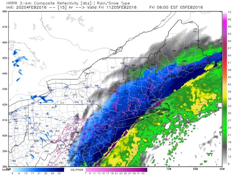
I feel its extremely dependent on precipitation intensity. Also, looking at the RAP/HRRR, if the changeover occurs prior to sunrise, surface temperatures will have the ability to cooler easier without any incoming solar radiation, lessening wasted QPF. A 5am changeover is more favorable rather than a 7am changeoversroc4 wrote:Latest HRRR valid 6am tomorrow morning. People are going to be very shocked by this system. I really dont think temps are goiong to hold down accumulations that much
Last edited by Quietace on Thu Feb 04, 2016 4:36 pm; edited 1 time in total

Quietace- Meteorologist - Mod

- Posts : 3687
Reputation : 33
Join date : 2013-01-07
Age : 27
Location : Point Pleasant, NJ
Re: Blog: February 5th Potential (Sneak Attack?)
![]() by jmanley32 Thu Feb 04, 2016 4:36 pm
by jmanley32 Thu Feb 04, 2016 4:36 pm
sroc4 wrote:Latest HRRR valid 6am tomorrow morning. People are going to be very shocked by this system. I really dont think temps are goiong to hold down accumulations that much
Wow beautiful but uggggly for a drive into city.
jmanley32- Senior Enthusiast
- Posts : 20516
Reputation : 108
Join date : 2013-12-12
Age : 42
Location : Yonkers, NY
Page 11 of 13 • 1, 2, 3 ... 10, 11, 12, 13 ![]()
|
|
|