
 Search
Sunday February 12th Possible Front-End Snow Thump
Page 5 of 14 •  1, 2, 3, 4, 5, 6 ... 9 ... 14
 ![]()
Re: Sunday February 12th Possible Front-End Snow Thump
![]() by amugs Sat Feb 11, 2017 3:29 pm
by amugs Sat Feb 11, 2017 3:29 pm
amugs- Advanced Forecaster - Mod

- Posts : 15095
Join date : 2013-01-07
Re: Sunday February 12th Possible Front-End Snow Thump
![]() by CPcantmeasuresnow Sat Feb 11, 2017 3:30 pm
by CPcantmeasuresnow Sat Feb 11, 2017 3:30 pm
hyde345 wrote:Just got winter storm warning for 4-8 of snow and sleet. I'm hoping for more snow than sleet.
Sounds like they're going a little conservative, but I guess with the possibility still lof mixing and sleet it could verify.
CPcantmeasuresnow- Wx Statistician Guru

- Posts : 7274
Join date : 2013-01-07
Re: Sunday February 12th Possible Front-End Snow Thump
![]() by Snow88 Sat Feb 11, 2017 3:32 pm
by Snow88 Sat Feb 11, 2017 3:32 pm
Up to an inch of snow and a few hundredths of Ice

Snow88- Senior Enthusiast

- Posts : 2193
Reputation : 4
Join date : 2013-01-09
Age : 35
Location : Brooklyn, NY
Re: Sunday February 12th Possible Front-End Snow Thump
![]() by hyde345 Sat Feb 11, 2017 3:35 pm
by hyde345 Sat Feb 11, 2017 3:35 pm
CPcantmeasuresnow wrote:hyde345 wrote:Just got winter storm warning for 4-8 of snow and sleet. I'm hoping for more snow than sleet.
Sounds like they're going a little conservative, but I guess with the possibility still lof mixing and sleet it could verify.
I agree about them being conservative. I guess they would rather be a little low than high.

hyde345- Pro Enthusiast

- Posts : 1082
Reputation : 48
Join date : 2013-01-08
Location : Hyde Park, NY
Re: Sunday February 12th Possible Front-End Snow Thump
![]() by jmanley32 Sat Feb 11, 2017 3:37 pm
by jmanley32 Sat Feb 11, 2017 3:37 pm
actually opposite direction. Been here in ct since last night. Was stay till mon but we not do so gr8 so since room is comped this go leave midday tomorrow. I just worry bout ice and I hate traffic back into nyc. No I cam def drive I grew up in new England .syosnow94 wrote:At exit 15 rest stop on NYS thruway. Heading up to mom and dads for the snowstorm tomorrow. They are under a WSW FOR 7"+. NWS POINT and click has them at 8-11". Driving home tomorrow night in the snow. Jman if I can do it with my family you can do it with a bunch of dudes from a casino. No need to cancel. Just drive my man.

jmanley32- Senior Enthusiast
- Posts : 20535
Reputation : 108
Join date : 2013-12-12
Age : 43
Location : Yonkers, NY
Re: Sunday February 12th Possible Front-End Snow Thump
![]() by jmanley32 Sat Feb 11, 2017 3:39 pm
by jmanley32 Sat Feb 11, 2017 3:39 pm
cool yeah I was think warning go b likely. Yeah I'll start a thread unless frank wants to incorporate it in this thread. I like to go out in the wind but I don't stand near trees...amugs wrote:JMAN FOR YOU - start a seperate thread for the winds if you'd like
.LONG TERM /MONDAY THROUGH FRIDAY/...
An amplifying short wave trough closes off just off the New
England Coast Monday. At the same time, high pressure will
build east from the Mississippi Valley. Thus, there is the
potential for high winds on the backside of the low late Sunday
night into Monday. Right now, we are looking at NW gusts up to
45 to 50 mph, but they could be stronger. An eventual Wind
Advisory at a minimum will be needed, but High Wind
Watches/Warnings are possible.
jmanley32- Senior Enthusiast
- Posts : 20535
Reputation : 108
Join date : 2013-12-12
Age : 43
Location : Yonkers, NY
Re: Sunday February 12th Possible Front-End Snow Thump
![]() by aiannone Sat Feb 11, 2017 3:40 pm
by aiannone Sat Feb 11, 2017 3:40 pm
_________________
-Alex Iannone-

aiannone- Senior Enthusiast - Mod
- Posts : 4815
Reputation : 92
Join date : 2013-01-07
Location : Saint James, LI (Northwest Suffolk Co.)
Re: Sunday February 12th Possible Front-End Snow Thump
![]() by jimv45 Sat Feb 11, 2017 3:41 pm
by jimv45 Sat Feb 11, 2017 3:41 pm
jimv45- Senior Enthusiast
- Posts : 1168
Reputation : 36
Join date : 2013-09-20
Location : Hopewell jct.
Re: Sunday February 12th Possible Front-End Snow Thump
![]() by jmanley32 Sat Feb 11, 2017 3:43 pm
by jmanley32 Sat Feb 11, 2017 3:43 pm
jmanley32- Senior Enthusiast
- Posts : 20535
Reputation : 108
Join date : 2013-12-12
Age : 43
Location : Yonkers, NY
Re: Sunday February 12th Possible Front-End Snow Thump
![]() by aiannone Sat Feb 11, 2017 3:47 pm
by aiannone Sat Feb 11, 2017 3:47 pm
_________________
-Alex Iannone-
aiannone- Senior Enthusiast - Mod
- Posts : 4815
Reputation : 92
Join date : 2013-01-07
Location : Saint James, LI (Northwest Suffolk Co.)
Re: Sunday February 12th Possible Front-End Snow Thump
![]() by aiannone Sat Feb 11, 2017 3:49 pm
by aiannone Sat Feb 11, 2017 3:49 pm
4k Hi-Res
_________________
-Alex Iannone-
aiannone- Senior Enthusiast - Mod
- Posts : 4815
Reputation : 92
Join date : 2013-01-07
Location : Saint James, LI (Northwest Suffolk Co.)
Re: Sunday February 12th Possible Front-End Snow Thump
![]() by hyde345 Sat Feb 11, 2017 3:51 pm
by hyde345 Sat Feb 11, 2017 3:51 pm
jimv45 wrote:Hyde I am thinking 6-10 if no mixing I wouldn't be surprised 10 will be a hit for us with no mixing
absolutely, with no mixing.
hyde345- Pro Enthusiast
- Posts : 1082
Reputation : 48
Join date : 2013-01-08
Location : Hyde Park, NY
Re: Sunday February 12th Possible Front-End Snow Thump
![]() by Dunnzoo Sat Feb 11, 2017 3:52 pm
by Dunnzoo Sat Feb 11, 2017 3:52 pm
aiannone wrote:
4k Hi-Res
Haha mugsy and I just get in to the action!
_________________
Janet
Snowfall winter of 2023-2024 17.5"
Snowfall winter of 2022-2023 6.0"
Snowfall winter of 2021-2022 17.6" 1" sleet 2/25/22
Snowfall winter of 2020-2021 51.1"
Snowfall winter of 2019-2020 8.5"
Snowfall winter of 2018-2019 25.1"
Snowfall winter of 2017-2018 51.9"
Snowfall winter of 2016-2017 45.6"
Snowfall winter of 2015-2016 29.5"
Snowfall winter of 2014-2015 50.55"
Snowfall winter of 2013-2014 66.5"

Dunnzoo- Senior Enthusiast - Mod
- Posts : 4905
Reputation : 68
Join date : 2013-01-11
Age : 62
Location : Westwood, NJ
Re: Sunday February 12th Possible Front-End Snow Thump
![]() by hyde345 Sat Feb 11, 2017 3:57 pm
by hyde345 Sat Feb 11, 2017 3:57 pm
aiannone wrote:
4k Hi-Res
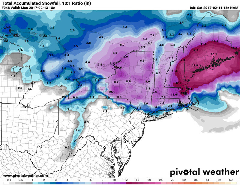
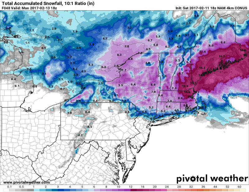
Those numbers seem kinda low to me, particularly up north around Albany area where they are expecting a foot.
hyde345- Pro Enthusiast
- Posts : 1082
Reputation : 48
Join date : 2013-01-08
Location : Hyde Park, NY
Re: Sunday February 12th Possible Front-End Snow Thump
![]() by 2004blackwrx Sat Feb 11, 2017 4:09 pm
by 2004blackwrx Sat Feb 11, 2017 4:09 pm
2004blackwrx- Pro Enthusiast
- Posts : 576
Reputation : 9
Join date : 2013-01-14
Location : Wappinger NY
Re: Sunday February 12th Possible Front-End Snow Thump
![]() by amugs Sat Feb 11, 2017 4:15 pm
by amugs Sat Feb 11, 2017 4:15 pm
Zoo lots of ice and snow for us - and winds Sunday night through monday - not a good recipe here

_________________
Mugs
AKA:King: Snow Weenie
Self Proclaimed
WINTER 2014-15 : 55.12" +.02 for 6 coatings (avg. 35")
WINTER 2015-16 Total - 29.8" (Avg 35")
WINTER 2016-17 : 39.5" so far

amugs- Advanced Forecaster - Mod
- Posts : 15095
Reputation : 213
Join date : 2013-01-07
Age : 54
Location : Hillsdale,NJ
Re: Sunday February 12th Possible Front-End Snow Thump
![]() by amugs Sat Feb 11, 2017 4:17 pm
by amugs Sat Feb 11, 2017 4:17 pm


_________________
Mugs
AKA:King: Snow Weenie
Self Proclaimed
WINTER 2014-15 : 55.12" +.02 for 6 coatings (avg. 35")
WINTER 2015-16 Total - 29.8" (Avg 35")
WINTER 2016-17 : 39.5" so far
amugs- Advanced Forecaster - Mod
- Posts : 15095
Reputation : 213
Join date : 2013-01-07
Age : 54
Location : Hillsdale,NJ
Re: Sunday February 12th Possible Front-End Snow Thump
![]() by amugs Sat Feb 11, 2017 4:18 pm
by amugs Sat Feb 11, 2017 4:18 pm
_________________
Mugs
AKA:King: Snow Weenie
Self Proclaimed
WINTER 2014-15 : 55.12" +.02 for 6 coatings (avg. 35")
WINTER 2015-16 Total - 29.8" (Avg 35")
WINTER 2016-17 : 39.5" so far
amugs- Advanced Forecaster - Mod
- Posts : 15095
Reputation : 213
Join date : 2013-01-07
Age : 54
Location : Hillsdale,NJ
Re: Sunday February 12th Possible Front-End Snow Thump
![]() by CPcantmeasuresnow Sat Feb 11, 2017 4:20 pm
by CPcantmeasuresnow Sat Feb 11, 2017 4:20 pm
aiannone wrote:
4k Hi-Res
backed off a bit, a little concerning but still just one run.

CPcantmeasuresnow- Wx Statistician Guru
- Posts : 7274
Reputation : 230
Join date : 2013-01-07
Age : 103
Location : Eastern Orange County, NY
Re: Sunday February 12th Possible Front-End Snow Thump
![]() by amugs Sat Feb 11, 2017 4:24 pm
by amugs Sat Feb 11, 2017 4:24 pm


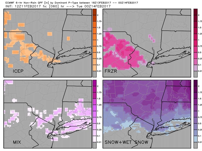
Remember sleet and zr are counted on these maps as snow - this is for NNJ and NYC
_________________
Mugs
AKA:King: Snow Weenie
Self Proclaimed
WINTER 2014-15 : 55.12" +.02 for 6 coatings (avg. 35")
WINTER 2015-16 Total - 29.8" (Avg 35")
WINTER 2016-17 : 39.5" so far
amugs- Advanced Forecaster - Mod
- Posts : 15095
Reputation : 213
Join date : 2013-01-07
Age : 54
Location : Hillsdale,NJ
Re: Sunday February 12th Possible Front-End Snow Thump
![]() by Frank_Wx Sat Feb 11, 2017 4:34 pm
by Frank_Wx Sat Feb 11, 2017 4:34 pm

_________________
_______________________________________________________________________________________________________
CLICK HERE to view NJ Strong Snowstorm Classifications

Frank_Wx- Godzilla Seeker

- Posts : 21305
Reputation : 328
Join date : 2013-01-05
Age : 32
Location : Jersey City, NJ -

Re: Sunday February 12th Possible Front-End Snow Thump
![]() by CPcantmeasuresnow Sat Feb 11, 2017 4:34 pm
by CPcantmeasuresnow Sat Feb 11, 2017 4:34 pm
amugs wrote:
Remember sleet and zr are counted on these maps as snow - this is for NNJ and NYC
540 line is way up in Albany in that picture what altitude is the model you posted depicting those upper level temps? Shows heavy snow in the HV but how with the 540 line so far north?
CPcantmeasuresnow- Wx Statistician Guru
- Posts : 7274
Reputation : 230
Join date : 2013-01-07
Age : 103
Location : Eastern Orange County, NY
Re: Sunday February 12th Possible Front-End Snow Thump
![]() by aiannone Sat Feb 11, 2017 4:38 pm
by aiannone Sat Feb 11, 2017 4:38 pm
540 line isn't always the r/s line. There is also an 850mb 0c line. Stormvista shows it nicelyCPcantmeasuresnow wrote:amugs wrote:
Remember sleet and zr are counted on these maps as snow - this is for NNJ and NYC
540 line is way up in Albany in that picture what altitude is the model you posted depicting those upper level temps? Shows heavy snow in the HV but how with the 540 line so far north?
_________________
-Alex Iannone-
aiannone- Senior Enthusiast - Mod
- Posts : 4815
Reputation : 92
Join date : 2013-01-07
Location : Saint James, LI (Northwest Suffolk Co.)
Re: Sunday February 12th Possible Front-End Snow Thump
![]() by Frank_Wx Sat Feb 11, 2017 4:40 pm
by Frank_Wx Sat Feb 11, 2017 4:40 pm

_________________
_______________________________________________________________________________________________________
CLICK HERE to view NJ Strong Snowstorm Classifications
Frank_Wx- Godzilla Seeker
- Posts : 21305
Reputation : 328
Join date : 2013-01-05
Age : 32
Location : Jersey City, NJ -
Re: Sunday February 12th Possible Front-End Snow Thump
![]() by aiannone Sat Feb 11, 2017 4:41 pm
by aiannone Sat Feb 11, 2017 4:41 pm

_________________
-Alex Iannone-
aiannone- Senior Enthusiast - Mod
- Posts : 4815
Reputation : 92
Join date : 2013-01-07
Location : Saint James, LI (Northwest Suffolk Co.)
Re: Sunday February 12th Possible Front-End Snow Thump
![]() by CPcantmeasuresnow Sat Feb 11, 2017 4:53 pm
by CPcantmeasuresnow Sat Feb 11, 2017 4:53 pm
aiannone wrote:540 line isn't always the r/s line. There is also an 850mb 0c line. Stormvista shows it nicelyCPcantmeasuresnow wrote:amugs wrote:
Remember sleet and zr are counted on these maps as snow - this is for NNJ and NYC
540 line is way up in Albany in that picture what altitude is the model you posted depicting those upper level temps? Shows heavy snow in the HV but how with the 540 line so far north?
Alex as depicted above what altitude are the lines depicting there? Usually it says whether it's 850 which I believe is 5,000 feet or 700, 925 etc.
CPcantmeasuresnow- Wx Statistician Guru
- Posts : 7274
Reputation : 230
Join date : 2013-01-07
Age : 103
Location : Eastern Orange County, NY
Re: Sunday February 12th Possible Front-End Snow Thump
![]() by Lnda23 Sat Feb 11, 2017 4:56 pm
by Lnda23 Sat Feb 11, 2017 4:56 pm

Lnda23- Posts : 30
Reputation : 3
Join date : 2013-01-08
Location : Garwood, NJ
Page 5 of 14 • 1, 2, 3, 4, 5, 6 ... 9 ... 14 ![]()
|
|
|