
 Search
FEB 17th-18th Snow? Sleet? Rain?
Page 5 of 15 •  1, 2, 3, 4, 5, 6 ... 10 ... 15
 ![]()
Re: FEB 17th-18th Snow? Sleet? Rain?
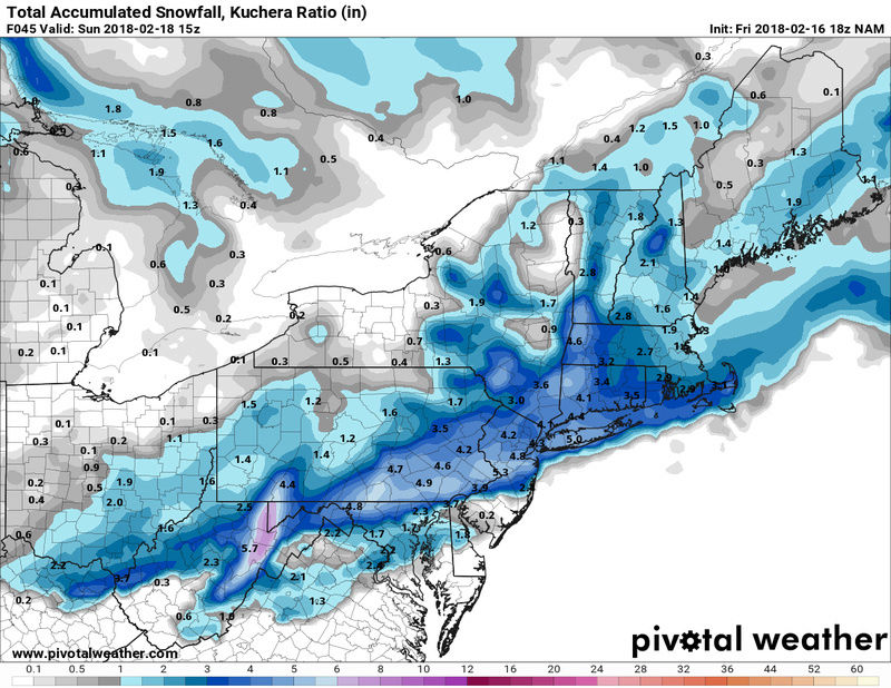
![]() by SoulSingMG Fri Feb 16, 2018 10:24 am
by SoulSingMG Fri Feb 16, 2018 10:24 am
NWS @ 12z:

SoulSingMG- Senior Enthusiast

- Posts : 2853
Join date : 2013-12-11
Re: FEB 17th-18th Snow? Sleet? Rain?
![]() by aiannone Fri Feb 16, 2018 11:32 am
by aiannone Fri Feb 16, 2018 11:32 am
At the afternoon or morning update package the NWS will convert watches to Advisories for 2-4" with isolated amounts of 5" in the heavier bands
aiannone- Senior Enthusiast - Mod

- Posts : 4815
Join date : 2013-01-07
Re: FEB 17th-18th Snow? Sleet? Rain?
![]() by aiannone Fri Feb 16, 2018 12:27 pm
by aiannone Fri Feb 16, 2018 12:27 pm
1128 AM EST Fri Feb 16 2018
...WINTER STORM WATCH REMAINS IN EFFECT FROM SATURDAY EVENING
THROUGH SUNDAY MORNING...
* WHAT...Heavy snow possible. Total snow accumulations of 4 to 7
inches are possible.
* WHERE...New York City, Southern Connecticut, Northeast New
Jersey, Long Island, and Rockland as well as Westchester
Counties in New York.
* WHEN...From Saturday evening through early Sunday morning.
* ADDITIONAL DETAILS...Plan on difficult travel conditions.
Significant reductions in visibility are possible.
PRECAUTIONARY/PREPAREDNESS ACTIONS...
A Winter Storm Watch means there is potential for significant
snow, sleet or ice accumulations that may impact travel. Continue
to monitor the latest forecasts.
_________________
-Alex Iannone-

aiannone- Senior Enthusiast - Mod
- Posts : 4815
Reputation : 92
Join date : 2013-01-07
Location : Saint James, LI (Northwest Suffolk Co.)
Re: FEB 17th-18th Snow? Sleet? Rain?
![]() by GreyBeard Fri Feb 16, 2018 12:40 pm
by GreyBeard Fri Feb 16, 2018 12:40 pm
aiannone wrote:My prediction:
At the afternoon or morning update package the NWS will convert watches to Advisories for 2-4" with isolated amounts of 5" in the heavier bands
Perhaps they will change their minds by later this afternoon, but as of 11:30 this AM, they are still calling for 4-7.
Winter Storm Watch
URGENT - WINTER WEATHER MESSAGE
National Weather Service New York NY
1128 AM EST Fri Feb 16 2018
CTZ005>012-NJZ002-004-006-103>108-NYZ069>075-078>081-176>179-
170030-
/O.CON.KOKX.WS.A.0004.180218T0000Z-180218T1200Z/
Northern Fairfield-Northern New Haven-Northern Middlesex-
Northern New London-Southern Fairfield-Southern New Haven-
Southern Middlesex-Southern New London-Western Passaic-
Eastern Passaic-Hudson-Western Bergen-Eastern Bergen-
Western Essex-Eastern Essex-Western Union-Eastern Union-Rockland-
Northern Westchester-Southern Westchester-New York (Manhattan)-
Bronx-Richmond (Staten Island)-Kings (Brooklyn)-
Northwestern Suffolk-Northeastern Suffolk-Southwestern Suffolk-
Southeastern Suffolk-Northern Queens-Northern Nassau-
Southern Queens-Southern Nassau-
1128 AM EST Fri Feb 16 2018
...WINTER STORM WATCH REMAINS IN EFFECT FROM SATURDAY EVENING
THROUGH SUNDAY MORNING...
* WHAT...Heavy snow possible. Total snow accumulations of 4 to 7
inches are possible.
* WHERE...New York City, Southern Connecticut, Northeast New
Jersey, Long Island, and Rockland as well as Westchester
Counties in New York.
* WHEN...From Saturday evening through early Sunday morning.
* ADDITIONAL DETAILS...Plan on difficult travel conditions.
Significant reductions in visibility are possible.
PRECAUTIONARY/PREPAREDNESS ACTIONS...
A Winter Storm Watch means there is potential for significant
snow, sleet or ice accumulations that may impact travel. Continue
to monitor the latest forecasts.
On a side note, Alex, did Frank hire you on as a full time poster? It seems like you are on here 24/7 lately.
GreyBeard- Senior Enthusiast
- Posts : 725
Reputation : 34
Join date : 2014-02-12
Location : eastern nassau county
GreyBeard- Senior Enthusiast
- Posts : 725
Reputation : 34
Join date : 2014-02-12
Location : eastern nassau county
Re: FEB 17th-18th Snow? Sleet? Rain?
![]() by aiannone Fri Feb 16, 2018 1:03 pm
by aiannone Fri Feb 16, 2018 1:03 pm
_________________
-Alex Iannone-
aiannone- Senior Enthusiast - Mod
- Posts : 4815
Reputation : 92
Join date : 2013-01-07
Location : Saint James, LI (Northwest Suffolk Co.)
Re: FEB 17th-18th Snow? Sleet? Rain?
![]() by aiannone Fri Feb 16, 2018 1:50 pm
by aiannone Fri Feb 16, 2018 1:50 pm
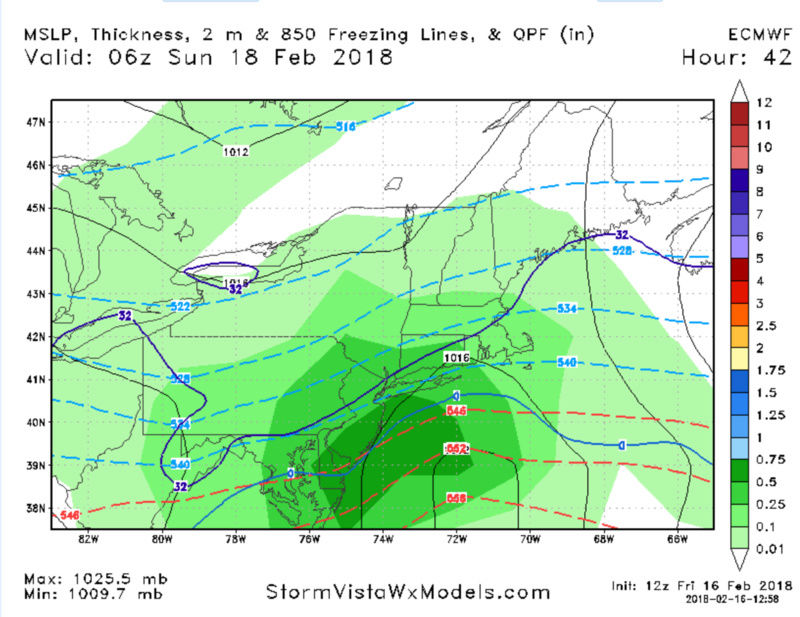
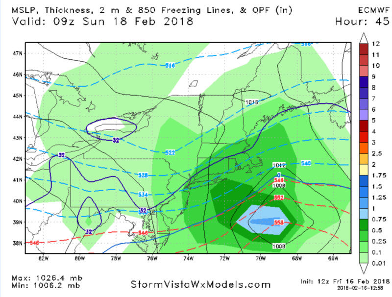
"Still some uncertainties remaining, but the Euro/UKIE solution is how to succeed w/ this event on the coast. Evacuate the column, induce adiabatic expansion, cool dynamically (with a bit of help melting+evaporational - but mostly dynamic), and the boundary layer will respond. What was/is missing on the GFS is precisely the process that would cool the lower boundary layer. Mid-levels are supportive, so the contingency is sufficiently strong vertical velocities to countermand the surface warmth. The Euro holding this afternoon was slightly surprising me to be completely honest, but I think the probability of more than a couple inches has increased for the coast. We should still fall below WSW criteria (6"), but it looks like a solid event in the midst of an otherwise unpropitious synoptic." - Tom AKA isotherm. This right here is $$ and why i mentioned above about the diabatic processes/mesoscale dynamics
_________________
-Alex Iannone-
aiannone- Senior Enthusiast - Mod
- Posts : 4815
Reputation : 92
Join date : 2013-01-07
Location : Saint James, LI (Northwest Suffolk Co.)
Re: FEB 17th-18th Snow? Sleet? Rain?
![]() by billg315 Fri Feb 16, 2018 1:50 pm
by billg315 Fri Feb 16, 2018 1:50 pm

billg315- Advanced Forecaster - Mod
- Posts : 4483
Reputation : 185
Join date : 2015-01-24
Age : 50
Location : Flemington, NJ
Re: FEB 17th-18th Snow? Sleet? Rain?
![]() by amugs Fri Feb 16, 2018 2:37 pm
by amugs Fri Feb 16, 2018 2:37 pm


WARNING LEVEL 4-8" SNOWSTORM WRITTEN ALL OVER THIS RUN!!
_________________
Mugs
AKA:King: Snow Weenie
Self Proclaimed
WINTER 2014-15 : 55.12" +.02 for 6 coatings (avg. 35")
WINTER 2015-16 Total - 29.8" (Avg 35")
WINTER 2016-17 : 39.5" so far

amugs- Advanced Forecaster - Mod
- Posts : 15095
Reputation : 213
Join date : 2013-01-07
Age : 54
Location : Hillsdale,NJ
Re: FEB 17th-18th Snow? Sleet? Rain?
![]() by aiannone Fri Feb 16, 2018 2:39 pm
by aiannone Fri Feb 16, 2018 2:39 pm
_________________
-Alex Iannone-
aiannone- Senior Enthusiast - Mod
- Posts : 4815
Reputation : 92
Join date : 2013-01-07
Location : Saint James, LI (Northwest Suffolk Co.)
Re: FEB 17th-18th Snow? Sleet? Rain?
![]() by aiannone Fri Feb 16, 2018 3:03 pm
by aiannone Fri Feb 16, 2018 3:03 pm
_________________
-Alex Iannone-
aiannone- Senior Enthusiast - Mod
- Posts : 4815
Reputation : 92
Join date : 2013-01-07
Location : Saint James, LI (Northwest Suffolk Co.)
Re: FEB 17th-18th Snow? Sleet? Rain?
![]() by aiannone Fri Feb 16, 2018 3:12 pm
by aiannone Fri Feb 16, 2018 3:12 pm
_________________
-Alex Iannone-
aiannone- Senior Enthusiast - Mod
- Posts : 4815
Reputation : 92
Join date : 2013-01-07
Location : Saint James, LI (Northwest Suffolk Co.)
Re: FEB 17th-18th Snow? Sleet? Rain?
![]() by aiannone Fri Feb 16, 2018 3:14 pm
by aiannone Fri Feb 16, 2018 3:14 pm
_________________
-Alex Iannone-
aiannone- Senior Enthusiast - Mod
- Posts : 4815
Reputation : 92
Join date : 2013-01-07
Location : Saint James, LI (Northwest Suffolk Co.)
Re: FEB 17th-18th Snow? Sleet? Rain?
![]() by aiannone Fri Feb 16, 2018 3:17 pm
by aiannone Fri Feb 16, 2018 3:17 pm
_________________
-Alex Iannone-
aiannone- Senior Enthusiast - Mod
- Posts : 4815
Reputation : 92
Join date : 2013-01-07
Location : Saint James, LI (Northwest Suffolk Co.)
Re: FEB 17th-18th Snow? Sleet? Rain?
![]() by frank 638 Fri Feb 16, 2018 3:20 pm
by frank 638 Fri Feb 16, 2018 3:20 pm
frank 638- Senior Enthusiast
- Posts : 2843
Reputation : 37
Join date : 2016-01-01
Age : 40
Location : bronx ny
Re: FEB 17th-18th Snow? Sleet? Rain?
![]() by aiannone Fri Feb 16, 2018 3:27 pm
by aiannone Fri Feb 16, 2018 3:27 pm
_________________
-Alex Iannone-
aiannone- Senior Enthusiast - Mod
- Posts : 4815
Reputation : 92
Join date : 2013-01-07
Location : Saint James, LI (Northwest Suffolk Co.)
Re: FEB 17th-18th Snow? Sleet? Rain?
![]() by aiannone Fri Feb 16, 2018 3:29 pm
by aiannone Fri Feb 16, 2018 3:29 pm
_________________
-Alex Iannone-
aiannone- Senior Enthusiast - Mod
- Posts : 4815
Reputation : 92
Join date : 2013-01-07
Location : Saint James, LI (Northwest Suffolk Co.)
Re: FEB 17th-18th Snow? Sleet? Rain?
![]() by aiannone Fri Feb 16, 2018 3:48 pm
by aiannone Fri Feb 16, 2018 3:48 pm
...WINTER STORM WATCH REMAINS IN EFFECT FROM SATURDAY EVENING
THROUGH EARLY SUNDAY MORNING...
* WHAT...Heavy snow possible. Total snow accumulations of 4 to 6
inches with locally higher amounts are possible.
* WHERE...Northeast New Jersey, New York City, Rockland and
Westchester Counties in New York, Long Island, and Southern
Connecticut.
* WHEN...From Saturday evening through early Sunday morning.
* ADDITIONAL DETAILS...Plan on difficult travel conditions.
Significant reductions in visibility are possible. Isolated
power outages possible due to weight of snow.
_________________
-Alex Iannone-
aiannone- Senior Enthusiast - Mod
- Posts : 4815
Reputation : 92
Join date : 2013-01-07
Location : Saint James, LI (Northwest Suffolk Co.)
Re: FEB 17th-18th Snow? Sleet? Rain?
![]() by aiannone Fri Feb 16, 2018 3:51 pm
by aiannone Fri Feb 16, 2018 3:51 pm


_________________
-Alex Iannone-
aiannone- Senior Enthusiast - Mod
- Posts : 4815
Reputation : 92
Join date : 2013-01-07
Location : Saint James, LI (Northwest Suffolk Co.)
Re: FEB 17th-18th Snow? Sleet? Rain?
![]() by Math23x7 Fri Feb 16, 2018 4:23 pm
by Math23x7 Fri Feb 16, 2018 4:23 pm
I firmly believe the N&W members will do the best in this event.
Math23x7- Wx Statistician Guru

- Posts : 2379
Reputation : 68
Join date : 2013-01-08
Re: FEB 17th-18th Snow? Sleet? Rain?
![]() by algae888 Fri Feb 16, 2018 4:31 pm
by algae888 Fri Feb 16, 2018 4:31 pm
Mike I don't know what rgem you're looking at but that's 3 to 6 inches for the borough's highest amounts in the Bronx of courseMath23x7 wrote:The RGEM continues to have more wet than white for the coast. While the 18Z RGEM was a bit more encouraging than the prior run, it's still going over to rain for NYC and LI.
I firmly believe the N&W members will do the best in this event.

algae888- Advanced Forecaster

- Posts : 5311
Reputation : 46
Join date : 2013-02-05
Age : 62
Location : mt. vernon, new york
Re: FEB 17th-18th Snow? Sleet? Rain?
![]() by RJB8525 Fri Feb 16, 2018 4:42 pm
by RJB8525 Fri Feb 16, 2018 4:42 pm
Sussex-Warren-Carbon-Monroe-Berks-Lehigh-Northampton-
Including the cities of Newton, Washington, Jim Thorpe,
Stroudsburg, Reading, Allentown, Bethlehem, and Easton
359 PM EST Fri Feb 16 2018
...WINTER STORM WATCH NOW IN EFFECT FROM SATURDAY AFTERNOON
THROUGH LATE SATURDAY NIGHT...
* WHAT...Heavy snow possible. Total snow accumulations of up to 5
inches are possible.
* WHERE...The Lehigh Valley and Berks County, the southern Poconos
and far northwestern New Jersey.
* WHEN...From Saturday afternoon through late Saturday night.
* ADDITIONAL DETAILS...Plan on difficult travel conditions.
Significant reductions in visibility are possible. There
remains some uncertainty with how much precipitation extends
this far westward, however there is the potential for a short
period of heavy snow Saturday night which could lead to a rapid
deterioration in road conditions.
now we wait and see i guess

RJB8525- Senior Enthusiast
- Posts : 1994
Reputation : 28
Join date : 2013-02-06
Age : 38
Location : Hackettstown, NJ
Re: FEB 17th-18th Snow? Sleet? Rain?
![]() by Guest Fri Feb 16, 2018 5:03 pm
by Guest Fri Feb 16, 2018 5:03 pm
billg315 wrote:I'm stating the obvious here I guess, but what a difficult forecast this is. I usually have a good sense of what I THINK is going to happen by this point (not that I'm always right), but I really am at a loss here. Usually you're dealing with either how far north or south the heaviest precipitation field extends, where the rain/snow line will be, or how long it will snow before it changes over. Here we are dealing with all three uncertainties AND the possible complication of warm ground temps after several days of spring-like weather. This is a tough one. Right now I think somebody is going to get a good dump of several inches of wet snow, and my guess is a line along and north of I-78. But I'm far from confident.
I said i wouldnt post about this threat till Friday evening cause im so disgusted with this pattern so here it is. Two things give me confidence. One is that Frank is in on this storm which says a lot. Secondly the NWS which is VERY CONSERVATIVE is bullish about it as well.
As far as the spring like weather goes Bill, the temp is dropping fast right now. 10 degrees in 2 hours. we are going down to the mid 20s tonight and only 35 or so tomorrow. the ground will be frozen solid. The precip comes in at night. I think we are good. Then it will all melt in 24 hours and we go back to torch.
Guest- Guest
Re: FEB 17th-18th Snow? Sleet? Rain?
![]() by aiannone Fri Feb 16, 2018 5:04 pm
by aiannone Fri Feb 16, 2018 5:04 pm
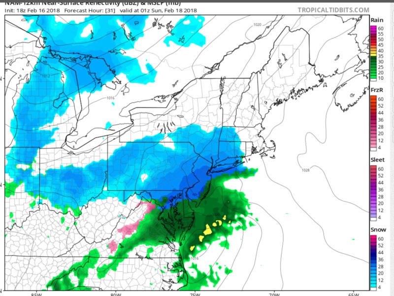
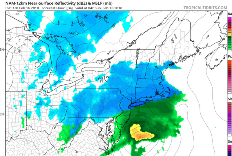
This low pressure system initially was developing today in SW
Pacific and this will have tracked through South Central US
through Tennessee Saturday. From there, it heads ENE into the
Mid-Atlantic Saturday evening and then deepens off the coast of
the Delmarva by late Saturday night. It takes a track to the SE
of the 40N/70W benchmark with boundary layer temperatures and
the magnitude of deepening of the low crucial to the amounts of
snow. The deeper the low, the more dynamic cooling there will be
and this goes with the intensity of the snow as well. It`s a
positive feedback loop, heavier snow would also force colder air
to the surface. The timing of this event Saturday night leans
more towards a colder solution compared if this were to occur
during the day.
Models have trended a little farther south with the low pressure
center and without a large pressure gradient between the
departing high and the approaching low, lowered snow amounts by
around an inch. Also on this side of a slight decrease will be
marginal boundary layer conditions at onset of snow. The
temperatures will be slightly above freezing and unless the snow
is quite intense, it will take an hour or so to decrease the
surface temperature to wet bulb temperature. So for first 1-2
hours, snow may not accumulate much. Looking at a general 9pm to
3am timeframe for much of the snow to fall.
Still see potential for banding with the snow with 1 inch per
hour snowfall amounts possible, so 4-6 inch snow amounts
forecast but with locally higher amounts possible. Where this
streak of higher amounts occurs is quite uncertain at this time
and that is why the winter storm watch was maintained and it
can`t be ruled out over Orange and Putnam New York, so watch was
expanded to those counties as well. Some higher snow
accumulation in the 6 to 8 inch range was shown in the latest
SREF but there are members on the lower end showing a few inches
as well. Snow rapidly trends down from west to east early
Sunday.
_________________
-Alex Iannone-
aiannone- Senior Enthusiast - Mod
- Posts : 4815
Reputation : 92
Join date : 2013-01-07
Location : Saint James, LI (Northwest Suffolk Co.)
Re: FEB 17th-18th Snow? Sleet? Rain?
![]() by jmanley32 Fri Feb 16, 2018 5:24 pm
by jmanley32 Fri Feb 16, 2018 5:24 pm
is euro serious, 70-75 mid next week?! thats got to be a record for whole month of february.syosnow94 wrote:billg315 wrote:I'm stating the obvious here I guess, but what a difficult forecast this is. I usually have a good sense of what I THINK is going to happen by this point (not that I'm always right), but I really am at a loss here. Usually you're dealing with either how far north or south the heaviest precipitation field extends, where the rain/snow line will be, or how long it will snow before it changes over. Here we are dealing with all three uncertainties AND the possible complication of warm ground temps after several days of spring-like weather. This is a tough one. Right now I think somebody is going to get a good dump of several inches of wet snow, and my guess is a line along and north of I-78. But I'm far from confident.
I said i wouldnt post about this threat till Friday evening cause im so disgusted with this pattern so here it is. Two things give me confidence. One is that Frank is in on this storm which says a lot. Secondly the NWS which is VERY CONSERVATIVE is bullish about it as well.
As far as the spring like weather goes Bill, the temp is dropping fast right now. 10 degrees in 2 hours. we are going down to the mid 20s tonight and only 35 or so tomorrow. the ground will be frozen solid. The precip comes in at night. I think we are good. Then it will all melt in 24 hours and we go back to torch.

jmanley32- Senior Enthusiast
- Posts : 20535
Reputation : 108
Join date : 2013-12-12
Age : 43
Location : Yonkers, NY
Re: FEB 17th-18th Snow? Sleet? Rain?
![]() by Guest Fri Feb 16, 2018 5:27 pm
by Guest Fri Feb 16, 2018 5:27 pm
Guest- Guest
Re: FEB 17th-18th Snow? Sleet? Rain?
![]() by jmanley32 Fri Feb 16, 2018 5:48 pm
by jmanley32 Fri Feb 16, 2018 5:48 pm
from looks of euro ytou can have that here.syosnow94 wrote:Heading down to Williamsburg Virginia next week with the family. mid 70s golf and swimming baby
jmanley32- Senior Enthusiast
- Posts : 20535
Reputation : 108
Join date : 2013-12-12
Age : 43
Location : Yonkers, NY
Page 5 of 15 • 1, 2, 3, 4, 5, 6 ... 10 ... 15 ![]()
|
|
|