
 Search
March 2nd Nor'easter Update
Page 9 of 40 •  1 ... 6 ... 8, 9, 10 ... 24 ... 40
 ![]()
Re: March 2nd Nor'easter Update
![]() by amugs Wed Feb 28, 2018 10:25 pm
by amugs Wed Feb 28, 2018 10:25 pm

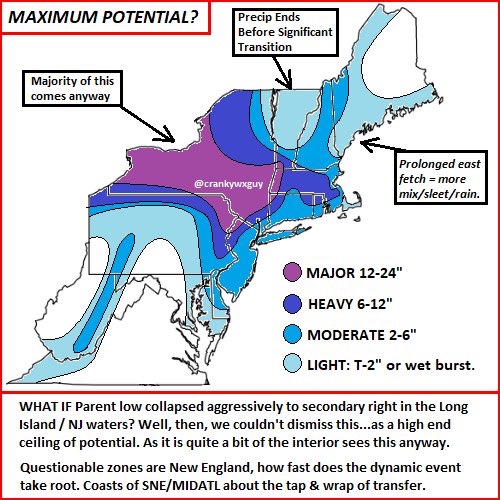
And NAM shows b conditions Friday commuting for NNJ
amugs- Advanced Forecaster - Mod

- Posts : 15093
Join date : 2013-01-07
Re: March 2nd Nor'easter Update
![]() by jmanley32 Wed Feb 28, 2018 10:26 pm
by jmanley32 Wed Feb 28, 2018 10:26 pm
I am okay with this map, coupled with the cooresponding wind map it would be a heck of a storm, and you go lose your lights for that my friend lol jk and actually where im located is more like 8-14 if you look close.syosnow94 wrote:This map is perfect. 15” for me. Only 6-10” for Jman and amugs. 1-2” for sroc4. Hahahaha. Sign me upjmanley32 wrote:I got my wxbell back wanted see closeups, your right 3km is about 6-12 for westchester even the city sees snow. I am really sorry LI folk, jeeze. Go post some nice close up maps for you guys.

By the way. The last 4 maps have my parents in nw Ulster County anywhere from 23-38”

jmanley32- Senior Enthusiast

- Posts : 20517
Join date : 2013-12-12
Re: March 2nd Nor'easter Update
![]() by jmanley32 Wed Feb 28, 2018 10:29 pm
by jmanley32 Wed Feb 28, 2018 10:29 pm
I posted rgem snow map, its all rain, verbatim.amugs wrote:RGEM caves
And NAM shows b conditions Friday commuting for NNJ

jmanley32- Senior Enthusiast
- Posts : 20517
Reputation : 108
Join date : 2013-12-12
Age : 42
Location : Yonkers, NY
Re: March 2nd Nor'easter Update
![]() by Dunnzoo Wed Feb 28, 2018 10:30 pm
by Dunnzoo Wed Feb 28, 2018 10:30 pm
_________________
Janet
Snowfall winter of 2023-2024 17.5"
Snowfall winter of 2022-2023 6.0"
Snowfall winter of 2021-2022 17.6" 1" sleet 2/25/22
Snowfall winter of 2020-2021 51.1"
Snowfall winter of 2019-2020 8.5"
Snowfall winter of 2018-2019 25.1"
Snowfall winter of 2017-2018 51.9"
Snowfall winter of 2016-2017 45.6"
Snowfall winter of 2015-2016 29.5"
Snowfall winter of 2014-2015 50.55"
Snowfall winter of 2013-2014 66.5"

Dunnzoo- Senior Enthusiast - Mod
- Posts : 4892
Reputation : 68
Join date : 2013-01-11
Age : 62
Location : Westwood, NJ
Re: March 2nd Nor'easter Update
![]() by jmanley32 Wed Feb 28, 2018 10:31 pm
by jmanley32 Wed Feb 28, 2018 10:31 pm
jmanley32- Senior Enthusiast
- Posts : 20517
Reputation : 108
Join date : 2013-12-12
Age : 42
Location : Yonkers, NY
Re: March 2nd Nor'easter Update
![]() by Sanz01 Wed Feb 28, 2018 10:32 pm
by Sanz01 Wed Feb 28, 2018 10:32 pm
Sanz01- Posts : 3
Reputation : 1
Join date : 2017-01-02
Re: March 2nd Nor'easter Update
![]() by CPcantmeasuresnow Wed Feb 28, 2018 10:33 pm
by CPcantmeasuresnow Wed Feb 28, 2018 10:33 pm
jmanley32 wrote:I am okay with this map, coupled with the cooresponding wind map it would be a heck of a storm, and you go lose your lights for that my friend lol jk and actually where im located is more like 8-14 if you look close.syosnow94 wrote:This map is perfect. 15” for me. Only 6-10” for Jman and amugs. 1-2” for sroc4. Hahahaha. Sign me upjmanley32 wrote:I got my wxbell back wanted see closeups, your right 3km is about 6-12 for westchester even the city sees snow. I am really sorry LI folk, jeeze. Go post some nice close up maps for you guys.
By the way. The last 4 maps have my parents in nw Ulster County anywhere from 23-38”
Jman if you look even closer his parents in Ulster county get about 2 inches on that map. They're in the blue scroo zone there.

CPcantmeasuresnow- Wx Statistician Guru

- Posts : 7274
Reputation : 230
Join date : 2013-01-07
Age : 103
Location : Eastern Orange County, NY
Re: March 2nd Nor'easter Update
![]() by jmanley32 Wed Feb 28, 2018 10:35 pm
by jmanley32 Wed Feb 28, 2018 10:35 pm
lol ehh at this point who knows and this map is very sensitive and any slight changes in banding will mean a world of changes to it. just thought id post it.CPcantmeasuresnow wrote:jmanley32 wrote:I am okay with this map, coupled with the cooresponding wind map it would be a heck of a storm, and you go lose your lights for that my friend lol jk and actually where im located is more like 8-14 if you look close.syosnow94 wrote:This map is perfect. 15” for me. Only 6-10” for Jman and amugs. 1-2” for sroc4. Hahahaha. Sign me upjmanley32 wrote:I got my wxbell back wanted see closeups, your right 3km is about 6-12 for westchester even the city sees snow. I am really sorry LI folk, jeeze. Go post some nice close up maps for you guys.
By the way. The last 4 maps have my parents in nw Ulster County anywhere from 23-38”
Jman if you look even closer his parents in Ulster county get about 2 inches on that map. They're in the blue scroo zone there.
jmanley32- Senior Enthusiast
- Posts : 20517
Reputation : 108
Join date : 2013-12-12
Age : 42
Location : Yonkers, NY
Re: March 2nd Nor'easter Update
![]() by jmanley32 Wed Feb 28, 2018 10:38 pm
by jmanley32 Wed Feb 28, 2018 10:38 pm
/O.CON.KOKX.HW.A.0001.180302T1200Z-180303T1100Z/
Southern Fairfield-Southern New Haven-Southern Middlesex-
Southern New London-Hudson-Eastern Essex-Eastern Union-
Southern Westchester-New York (Manhattan)-Bronx-
Richmond (Staten Island)-Kings (Brooklyn)-Northwestern Suffolk-
Northeastern Suffolk-Southwestern Suffolk-Southeastern Suffolk-
Northern Queens-Northern Nassau-Southern Queens-Southern Nassau-
1033 PM EST Wed Feb 28 2018
...HIGH WIND WATCH REMAINS IN EFFECT FROM FRIDAY MORNING THROUGH
LATE FRIDAY NIGHT...
* WINDS...North 25 to 40 mph with gusts up to 60 mph.
* TIMING...Friday and Friday night, with the strongest winds
from Friday afternoon through Friday evening.
* IMPACTS...Damaging winds will blow down trees and power lines.
Widespread power outages are expected. Travel will be
difficult, especially for high profile vehicles.
jmanley32- Senior Enthusiast
- Posts : 20517
Reputation : 108
Join date : 2013-12-12
Age : 42
Location : Yonkers, NY
Re: March 2nd Nor'easter Update
![]() by amugs Wed Feb 28, 2018 10:49 pm
by amugs Wed Feb 28, 2018 10:49 pm
We can go from a flood watch to a wsw the way Upton goes in a one update the way this bad, bad boy is trending.
See ya in da morning for Al's 2 pages of posts at 4 AM!!
Gonna need some rest peeps. Gonna be a cool of long nights but exiliarating ones. Oh and we go again next week.
_________________
Mugs
AKA:King: Snow Weenie
Self Proclaimed
WINTER 2014-15 : 55.12" +.02 for 6 coatings (avg. 35")
WINTER 2015-16 Total - 29.8" (Avg 35")
WINTER 2016-17 : 39.5" so far

amugs- Advanced Forecaster - Mod
- Posts : 15093
Reputation : 213
Join date : 2013-01-07
Age : 54
Location : Hillsdale,NJ
Frankdp23- Posts : 11
Reputation : 1
Join date : 2018-02-28
Age : 45
Location : Branchburg, NJ
Re: March 2nd Nor'easter Update
![]() by weatherwatchermom Wed Feb 28, 2018 10:52 pm
by weatherwatchermom Wed Feb 28, 2018 10:52 pm
Last edited by weatherwatchermom on Wed Feb 28, 2018 10:53 pm; edited 1 time in total

weatherwatchermom- Senior Enthusiast
- Posts : 3750
Reputation : 77
Join date : 2014-11-25
Age : 60
Location : Hazlet Township, NJ
Re: March 2nd Nor'easter Update
![]() by rb924119 Wed Feb 28, 2018 10:52 pm
by rb924119 Wed Feb 28, 2018 10:52 pm
Math23x7 wrote:The 0Z RGEM brings snow closer to NYC than the 18Z RGEM but it's still a mainly rain event for NYC. Keep in mind that with the March sun, snow with marginal temperatures will struggle to stick unless your dealing with high rates. Now, if the steady snow waits until Friday evening, then I can see it accumulating. But I'm not excited about potential snow in NYC...yet.
Not true, mikey. Once you overcome the initial layer, you will accumulate. The snow is going to have such a high water content especially at first, and the aggregate flakes will be so large, they will not be able to melt rapidly, and therefore quickly overcome the thermal imbalance. Once that process is established, it can snow lightly and still accumulate because it falls on snow that is freezing. Obviously warmer surfaces will take longer, but cars, grass, trees, etc. will not take long at all.
rb924119- Meteorologist

- Posts : 6890
Reputation : 194
Join date : 2013-02-06
Age : 32
Location : Greentown, Pa
Re: March 2nd Nor'easter Update
![]() by WeatherBob Wed Feb 28, 2018 10:55 pm
by WeatherBob Wed Feb 28, 2018 10:55 pm

WeatherBob- Meteorologist
- Posts : 683
Reputation : 83
Join date : 2013-12-13
Location : Caldwell, NJ - NW Essex County - Altitude 500 FT
Re: March 2nd Nor'easter Update
![]() by Radz Wed Feb 28, 2018 11:03 pm
by Radz Wed Feb 28, 2018 11:03 pm

Radz- Pro Enthusiast

- Posts : 1028
Reputation : 17
Join date : 2013-01-12
Location : Cortlandt Manor NY
Re: March 2nd Nor'easter Update
![]() by jmanley32 Wed Feb 28, 2018 11:10 pm
by jmanley32 Wed Feb 28, 2018 11:10 pm
he is good.Radz wrote:Lee Goldberg is the only Met I've seen talking about the heavy snow aspect...
jmanley32- Senior Enthusiast
- Posts : 20517
Reputation : 108
Join date : 2013-12-12
Age : 42
Location : Yonkers, NY
Re: March 2nd Nor'easter Update
![]() by rb924119 Wed Feb 28, 2018 11:11 pm
by rb924119 Wed Feb 28, 2018 11:11 pm
rb924119- Meteorologist
- Posts : 6890
Reputation : 194
Join date : 2013-02-06
Age : 32
Location : Greentown, Pa
Re: March 2nd Nor'easter Update
![]() by rb924119 Wed Feb 28, 2018 11:14 pm
by rb924119 Wed Feb 28, 2018 11:14 pm
rb924119- Meteorologist
- Posts : 6890
Reputation : 194
Join date : 2013-02-06
Age : 32
Location : Greentown, Pa
Re: March 2nd Nor'easter Update
![]() by jmanley32 Wed Feb 28, 2018 11:22 pm
by jmanley32 Wed Feb 28, 2018 11:22 pm
oh for goofus sakes!! My guess tomorrow midday Wind Watches go to warnings and get extended inland, WSW go to warnings, some places go straight to warnings no time for watches and its game on...my hope anyways. I am unable to look at my phone from 8am till 12:30 or so then I have 15 min or so till 2pm. Go be hard day LOLrb924119 wrote:Well aloft it caved. Surface maps still don't show it lol
jmanley32- Senior Enthusiast
- Posts : 20517
Reputation : 108
Join date : 2013-12-12
Age : 42
Location : Yonkers, NY
Re: March 2nd Nor'easter Update
![]() by WeatherBob Wed Feb 28, 2018 11:34 pm
by WeatherBob Wed Feb 28, 2018 11:34 pm
WeatherBob- Meteorologist
- Posts : 683
Reputation : 83
Join date : 2013-12-13
Location : Caldwell, NJ - NW Essex County - Altitude 500 FT
Re: March 2nd Nor'easter Update
![]() by rb924119 Wed Feb 28, 2018 11:38 pm
by rb924119 Wed Feb 28, 2018 11:38 pm
WeatherBob wrote:I usually don’t make snow forecasts, but I can see widespread 6 to 10 inches for NNJ just due to the wet nature of the snow. Won’t be surprised to see 12 to 14 in higher elevations of Passaic , Morris and Sussex counties. That’s all I am gonna say about snowfall totals unless something catches my eye on tmrw mornings runs. I just want to sit back and enjoy the storm.
I totally respect your input, but in all honesty, I can easily see how those numbers are doubled here. Not even kidding. Not saying it's GOING to happen definitively, as I have not been able to and cannot look at those details, but given everything I have, I'm probably 50-50 with it. It definitely would not surprise me, I'll put it that way lol
rb924119- Meteorologist
- Posts : 6890
Reputation : 194
Join date : 2013-02-06
Age : 32
Location : Greentown, Pa
Re: March 2nd Nor'easter Update
![]() by jmanley32 Wed Feb 28, 2018 11:45 pm
by jmanley32 Wed Feb 28, 2018 11:45 pm
what do you feel the ceiling here could b?rb924119 wrote:WeatherBob wrote:I usually don’t make snow forecasts, but I can see widespread 6 to 10 inches for NNJ just due to the wet nature of the snow. Won’t be surprised to see 12 to 14 in higher elevations of Passaic , Morris and Sussex counties. That’s all I am gonna say about snowfall totals unless something catches my eye on tmrw mornings runs. I just want to sit back and enjoy the storm.
I totally respect your input, but in all honesty, I can easily see how those numbers are doubled here. Not even kidding. Not saying it's GOING to happen definitively, as I have not been able to and cannot look at those details, but given everything I have, I'm probably 50-50 with it. It definitely would not surprise me, I'll put it that way lol
jmanley32- Senior Enthusiast
- Posts : 20517
Reputation : 108
Join date : 2013-12-12
Age : 42
Location : Yonkers, NY
Re: March 2nd Nor'easter Update
![]() by WeatherBob Wed Feb 28, 2018 11:50 pm
by WeatherBob Wed Feb 28, 2018 11:50 pm
I really only have been focusing on the 500 and 700 maps to make my forecast form this particular storm. Also , I am only forecasting for NNJ since that is what I am comfortable and familiar with.
Last edited by WeatherBob on Wed Feb 28, 2018 11:57 pm; edited 1 time in total
WeatherBob- Meteorologist
- Posts : 683
Reputation : 83
Join date : 2013-12-13
Location : Caldwell, NJ - NW Essex County - Altitude 500 FT
Re: March 2nd Nor'easter Update
![]() by SoulSingMG Wed Feb 28, 2018 11:51 pm
by SoulSingMG Wed Feb 28, 2018 11:51 pm

SoulSingMG- Senior Enthusiast
- Posts : 2853
Reputation : 74
Join date : 2013-12-11
Location : Long Island City, NY
Re: March 2nd Nor'easter Update
![]() by essexcountypete Thu Mar 01, 2018 12:18 am
by essexcountypete Thu Mar 01, 2018 12:18 am
...is Gfs denied!Frankdp23 wrote:Gfs delayed
Welcome aboard Frank!
Apparently this is the forum for people named Frank.

essexcountypete- Pro Enthusiast
- Posts : 783
Reputation : 12
Join date : 2013-12-09
Location : Bloomfield, NJ
Re: March 2nd Nor'easter Update
![]() by SoulSingMG Thu Mar 01, 2018 12:19 am
by SoulSingMG Thu Mar 01, 2018 12:19 am
SoulSingMG- Senior Enthusiast
- Posts : 2853
Reputation : 74
Join date : 2013-12-11
Location : Long Island City, NY
Re: March 2nd Nor'easter Update
![]() by jmanley32 Thu Mar 01, 2018 12:25 am
by jmanley32 Thu Mar 01, 2018 12:25 am
omg soul soul hrdps!!! Lp deepens sooner NYC getting crushed omg wow!!!SoulSingMG wrote:00z UKIE is huge, even for the City so I am hearing. No maps to post yet.
jmanley32- Senior Enthusiast
- Posts : 20517
Reputation : 108
Join date : 2013-12-12
Age : 42
Location : Yonkers, NY
Page 9 of 40 • 1 ... 6 ... 8, 9, 10 ... 24 ... 40 ![]()
|
|
|