FLORENCE: East Coast Threat or Does She Sleep With the Fishes?
+23
bobjohnsonforthehall
mwilli5783
Math23x7
jwalsh
frank 638
billg315
larryrock72
Dunnzoo
Radz
weatherwatchermom
nutleyblizzard
rb924119
Zhukov1945
SoulSingMG
amugs
Sanchize06
Frank_Wx
jmanley32
Joe Snow
algae888
Grselig
Quietace
sroc4
27 posters
Page 5 of 20
Page 5 of 20 •  1, 2, 3, 4, 5, 6 ... 12 ... 20
Quietace- Meteorologist - Mod

- Posts : 3689
Join date : 2013-01-07
sroc4- Admin

- Posts : 8354
Join date : 2013-01-07
 Re: FLORENCE: East Coast Threat or Does She Sleep With the Fishes?
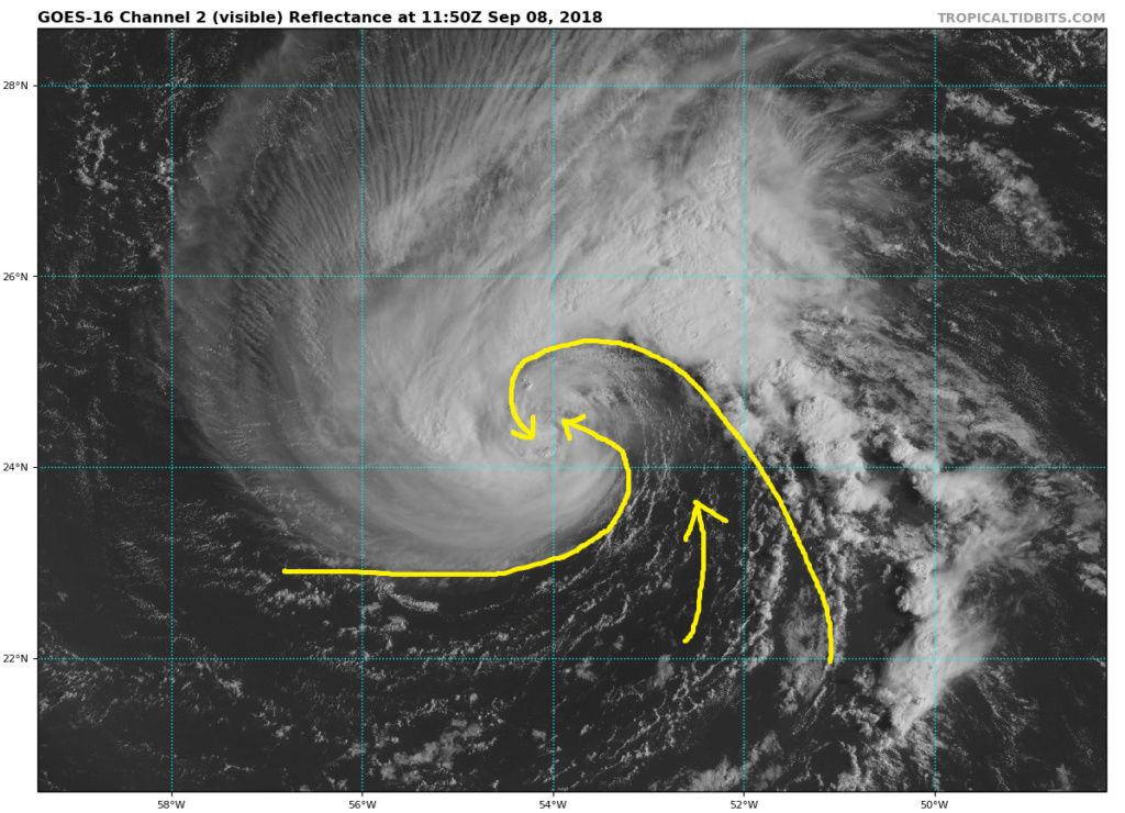
Which will have some significant short-term intensity implications (Florence looks pretty bad on IR compared to, as you said, this morning). The SW movement also continues with the COC almost at 24 N now (it was closer to 25 ish N earlier today).

Quietace- Meteorologist - Mod

- Posts : 3689
Reputation : 33
Join date : 2013-01-07
Age : 27
Location : Point Pleasant, NJ
 Re: FLORENCE: East Coast Threat or Does She Sleep With the Fishes?
Rayno:
"Look for guidance to start moving adjusting the tracks further north..well that's my theory. My area (assuming landfall) is between Myrtle Beach to Cape Cod."
"Look for guidance to start moving adjusting the tracks further north..well that's my theory. My area (assuming landfall) is between Myrtle Beach to Cape Cod."

SoulSingMG- Senior Enthusiast

- Posts : 2853
Reputation : 74
Join date : 2013-12-11
Location : Long Island City, NY
 Re: FLORENCE: East Coast Threat or Does She Sleep With the Fishes?
Checked in with some pro mets videos last night and they are expecting GFS to adjust south toward Euro and head toward the Carolinas. Then it's just a matter of how far inland it tracks as it heads north.
_________________
Janet
Snowfall winter of 2023-2024 17.5"
Snowfall winter of 2022-2023 6.0"
Snowfall winter of 2021-2022 17.6" 1" sleet 2/25/22
Snowfall winter of 2020-2021 51.1"
Snowfall winter of 2019-2020 8.5"
Snowfall winter of 2018-2019 25.1"
Snowfall winter of 2017-2018 51.9"
Snowfall winter of 2016-2017 45.6"
Snowfall winter of 2015-2016 29.5"
Snowfall winter of 2014-2015 50.55"
Snowfall winter of 2013-2014 66.5"
Dunnzoo- Senior Enthusiast - Mod

- Posts : 4904
Reputation : 68
Join date : 2013-01-11
Age : 62
Location : Westwood, NJ
 Re: FLORENCE: East Coast Threat or Does She Sleep With the Fishes?
SROC says maybe north. Rayno says north. Other pro mets say south. Our own Quiet Ace suggests south because of the block. Going to be interesting to see what really pans out.

Grselig- Senior Enthusiast

- Posts : 1408
Reputation : 140
Join date : 2013-03-04
Age : 54
Location : Wayne NJ
 Re: FLORENCE: East Coast Threat or Does She Sleep With the Fishes?
Any chance the blocking high is not as strong or weakens? Then maybe she skirts the outer banks and ots?
larryrock72- Posts : 140
Reputation : 5
Join date : 2017-01-03
Age : 52
Location : Barnegat, NJ
 Re: FLORENCE: East Coast Threat or Does She Sleep With the Fishes?
larryrock72 wrote:Any chance the blocking high is not as strong or weakens? Then maybe she skirts the outer banks and ots?
That's the key, the strength of the block. If it weakens the storm could turn north sooner, bringing landfall further north. That's why mets won't lock in a southern landfall yet...
_________________
Janet
Snowfall winter of 2023-2024 17.5"
Snowfall winter of 2022-2023 6.0"
Snowfall winter of 2021-2022 17.6" 1" sleet 2/25/22
Snowfall winter of 2020-2021 51.1"
Snowfall winter of 2019-2020 8.5"
Snowfall winter of 2018-2019 25.1"
Snowfall winter of 2017-2018 51.9"
Snowfall winter of 2016-2017 45.6"
Snowfall winter of 2015-2016 29.5"
Snowfall winter of 2014-2015 50.55"
Snowfall winter of 2013-2014 66.5"

Dunnzoo- Senior Enthusiast - Mod

- Posts : 4904
Reputation : 68
Join date : 2013-01-11
Age : 62
Location : Westwood, NJ
 Re: FLORENCE: East Coast Threat or Does She Sleep With the Fishes?
SoulSingMG wrote:Rayno:
"Look for guidance to start moving adjusting the tracks further north..well that's my theory. My area (assuming landfall) is between Myrtle Beach to Cape Cod."

Quietace- Meteorologist - Mod

- Posts : 3689
Reputation : 33
Join date : 2013-01-07
Age : 27
Location : Point Pleasant, NJ
 Re: FLORENCE: East Coast Threat or Does She Sleep With the Fishes?
12z Hurricane models, a grouping now east of NC. That grouping is very similar to the trend within the GFS and ICON the past few runs. Can't really tell if it stalls or it's the end of the run


Sanchize06- Senior Enthusiast

- Posts : 1041
Reputation : 21
Join date : 2013-02-05
Location : Union Beach, NJ
 Re: FLORENCE: East Coast Threat or Does She Sleep With the Fishes?
0Z FV3-GFS has a wacky run. I think once the recon data starts to come in the tracks will tighten.
Till then we track and track
Till then we track and track

Joe Snow- Pro Enthusiast

- Posts : 924
Reputation : 7
Join date : 2014-02-12
Age : 62
Location : Sanford Florida, Fmrly Kings Park, NY
 Re: FLORENCE: East Coast Threat or Does She Sleep With the Fishes?
My current thinking (for what it’s worth - which is not much) is that the system and trailing front with Gordo’s moisture moves through between Sunday and Tuesday. High Pressure slides over Eastern Canada/New England behind it mid-week as the front sinks south. Florence gets initially held south and makes landfall in North Carolina, but as the High slides east and a new front dives into the Midwest the remnants of Florence gets steered back northeast over VA, PA, NJ, CT or LI before exiting out to sea. This produces hurricane impacts in NC then heavy rains and flooding for most of the mid-Atlantic and our region with minimal winds (some gusts). If looking for a similar path I’d say Hurricane Diane 1955. (Just the path; That storm had some of its energy used up by Connie which made landfall in the same spot a few days earlier, although the combined effects of those storms produced epic flooding).

billg315- Advanced Forecaster - Mod

- Posts : 4483
Reputation : 185
Join date : 2015-01-24
Age : 50
Location : Flemington, NJ
 Re: FLORENCE: East Coast Threat or Does She Sleep With the Fishes?
If one wants a further north solution to take place (which ashamed to say I'm one of them), you need one of two things to happen... Florence intensifies quicker than forecasted which in turn changes the upper levels enough to bring the storm on a more WNW path vs west. Or better yet, the forward speed of Florence slows down which allows the high to move eastward thus allowing the storm to catch up to the ridge's western flank thus opening up a path to bring her up the coastline.billg315 wrote:My current thinking (for what it’s worth - which is not much) is that the system and trailing front with Gordo’s moisture moves through between Sunday and Tuesday. High Pressure slides over Eastern Canada/New England behind it mid-week as the front sinks south. Florence gets initially held south and makes landfall in North Carolina, but as the High slides east and a new front dives into the Midwest the remnants of Florence gets steered back northeast over VA, PA, NJ, CT or LI before exiting out to sea. This produces hurricane impacts in NC then heavy rains and flooding for most of the mid-Atlantic and our region with minimal winds (some gusts). If looking for a similar path I’d say Hurricane Diane 1955. (Just the path; That storm had some of its energy used up by Connie which made landfall in the same spot a few days earlier, although the combined effects of those storms produced epic flooding).

nutleyblizzard- Senior Enthusiast

- Posts : 1954
Reputation : 41
Join date : 2014-01-30
Age : 58
Location : Nutley, new jersey
 Re: FLORENCE: East Coast Threat or Does She Sleep With the Fishes?
I think their cone is a little too far south. I don't see this going into FL or GA. But I also do not see it getting into the Delmarva or SNJ. So...Carolina's should be on alert.
And yes, it is possible the remnants track our way to bring heavy tropical rainfall. That would pretty much be the extent of it for us.

And yes, it is possible the remnants track our way to bring heavy tropical rainfall. That would pretty much be the extent of it for us.

_________________
_______________________________________________________________________________________________________
CLICK HERE to view NJ Strong Snowstorm Classifications
 Re: FLORENCE: East Coast Threat or Does She Sleep With the Fishes?
Florence still at 65mph at the 11am advisory. Pressure down 1mb to 995. Does looks better organized though. It'll be interesting to see if she becomes a hurricane again by tonight
Sanchize06- Senior Enthusiast

- Posts : 1041
Reputation : 21
Join date : 2013-02-05
Location : Union Beach, NJ
 Re: FLORENCE: East Coast Threat or Does She Sleep With the Fishes?
INIT 08/1500Z 24.5N 54.3W 55 KT 65 MPH
12H 09/0000Z 24.6N 55.0W 60 KT 70 MPH
24H 09/1200Z 24.6N 56.1W 70 KT 80 MPH
36H 10/0000Z 24.8N 57.5W 85 KT 100 MPH
48H 10/1200Z 25.1N 59.3W 100 KT 115 MPH
72H 11/1200Z 26.3N 64.9W 115 KT 130 MPH
96H 12/1200Z 28.5N 71.5W 125 KT 145 MPH
120H 13/1200Z 31.5N 77.0W 120 KT 140 MPH
12H 09/0000Z 24.6N 55.0W 60 KT 70 MPH
24H 09/1200Z 24.6N 56.1W 70 KT 80 MPH
36H 10/0000Z 24.8N 57.5W 85 KT 100 MPH
48H 10/1200Z 25.1N 59.3W 100 KT 115 MPH
72H 11/1200Z 26.3N 64.9W 115 KT 130 MPH
96H 12/1200Z 28.5N 71.5W 125 KT 145 MPH
120H 13/1200Z 31.5N 77.0W 120 KT 140 MPH
Sanchize06- Senior Enthusiast

- Posts : 1041
Reputation : 21
Join date : 2013-02-05
Location : Union Beach, NJ
 Re: FLORENCE: East Coast Threat or Does She Sleep With the Fishes?
Frank_Wx wrote:I think their cone is a little too far south. I don't see this going into FL or GA. But I also do not see it getting into the Delmarva or SNJ. So...Carolina's should be on alert.
And yes, it is possible the remnants track our way to bring heavy tropical rainfall. That would pretty much be the extent of it for us.
Latest cone/advisory:


SoulSingMG- Senior Enthusiast

- Posts : 2853
Reputation : 74
Join date : 2013-12-11
Location : Long Island City, NY
 Re: FLORENCE: East Coast Threat or Does She Sleep With the Fishes?
Well after reading Frank's post I guess I'm done for now. Will keep an eye but as usual climo takes the cake for area of impact.

jmanley32- Senior Enthusiast

- Posts : 20535
Reputation : 108
Join date : 2013-12-12
Age : 43
Location : Yonkers, NY
 Re: FLORENCE: East Coast Threat or Does She Sleep With the Fishes?
jmanley32 wrote:Well after reading Frank's post I guess I'm done for now. Will keep an eye but as usual climo takes the cake for area of impact.
Until tomorrow's 00z Euro shows her coming up the coast lol. It's just too early to say where she'll landfall. Much more confidence to be had beyond tomorrow night. FWIW, Cranky (whom you all love lol) and several others are pointing out factors as to why they think a north trend will start soon.

SoulSingMG- Senior Enthusiast

- Posts : 2853
Reputation : 74
Join date : 2013-12-11
Location : Long Island City, NY
 Re: FLORENCE: East Coast Threat or Does She Sleep With the Fishes?
What is the "why" in the reasoning for that? I'm just sitting at my desk coding so I am playing devil's advocate.SoulSingMG wrote:jmanley32 wrote:Well after reading Frank's post I guess I'm done for now. Will keep an eye but as usual climo takes the cake for area of impact.
Until tomorrow's 00z Euro shows her coming up the coast lol. It's just too early to say where she'll landfall. Much more confidence to be had beyond tomorrow night. FWIW, Cranky (whom you all love lol) and several others are pointing out factors as to why they think a north trend will start soon.

Quietace- Meteorologist - Mod

- Posts : 3689
Reputation : 33
Join date : 2013-01-07
Age : 27
Location : Point Pleasant, NJ
 Re: FLORENCE: East Coast Threat or Does She Sleep With the Fishes?
SoulSingMG wrote:Frank_Wx wrote:I think their cone is a little too far south. I don't see this going into FL or GA. But I also do not see it getting into the Delmarva or SNJ. So...Carolina's should be on alert.
And yes, it is possible the remnants track our way to bring heavy tropical rainfall. That would pretty much be the extent of it for us.
Latest cone/advisory:
Still too far south for my liking. I would capture SC, NC, and southern VA
_________________
_______________________________________________________________________________________________________
CLICK HERE to view NJ Strong Snowstorm Classifications
 Re: FLORENCE: East Coast Threat or Does She Sleep With the Fishes?
Quietace wrote:What is the "why" in the reasoning for that? I'm just sitting at my desk coding so I am playing devil's advocate.SoulSingMG wrote:jmanley32 wrote:Well after reading Frank's post I guess I'm done for now. Will keep an eye but as usual climo takes the cake for area of impact.
Until tomorrow's 00z Euro shows her coming up the coast lol. It's just too early to say where she'll landfall. Much more confidence to be had beyond tomorrow night. FWIW, Cranky (whom you all love lol) and several others are pointing out factors as to why they think a north trend will start soon.
Unresolved atmospheric entities ;-)
@crankywxguy:
"I slept on Thursday's thoughts and wrote the new entry on Friday to account for the evolution during benchmark one.
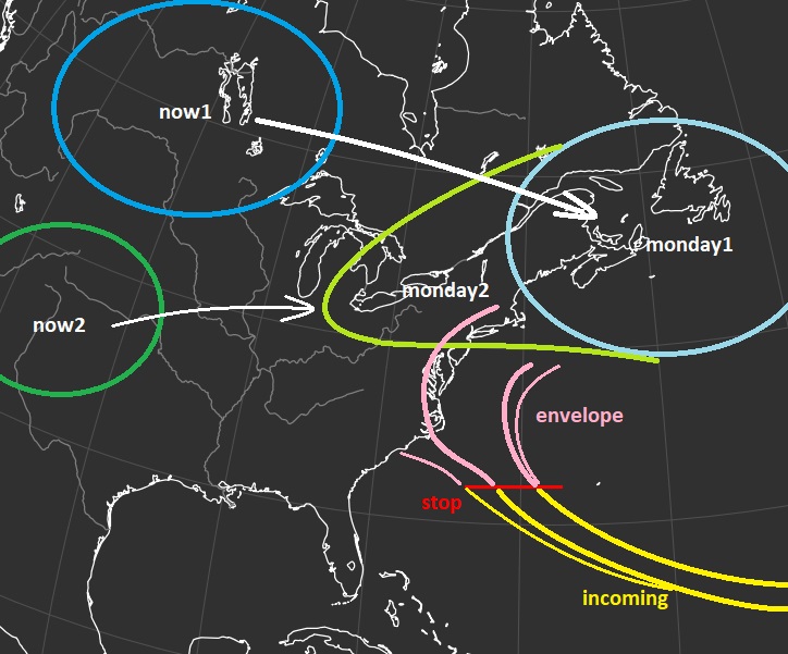
This produced your new envelope and then started to explain what has to happen next. This graphic from early Friday still stands. We have the stop point right where Florence enters the south west Atlantic and that is that. I have my envelope I end the smaller outside obejective potential. Do I have to shift this south and west? Maybe but I doubt it and only when the observations say so. No other way.
The highs and the problem to rebuild them. See, this is what those two pieces want to do. Gordon is between them and very strong as discussed further above. It is still a problem not yet resolved. Until it is you stay with a stop point in confidence and the downstream larger envelope remains.
Options still remain here. I personally still think we halt early somewhere around Hatteras to Virginia Capes and turn a little offshore. Then what I dont know. Coastal parallel, draw away from the coast, perhaps loop...all possible because of all those other smaller entities that Florence has to dance with. Very tricky and that portion will not be resolved until Tuesday or Wednesday. Just telling the truth here.
First we got to get past the stop point which I think we can do tomorrow. Then hopefully modeling will tighten up and we can start to incorporate it to start to narrow this down. Then draw a new focused envelope and start going for impacts."
Last edited by SoulSingMG on Sat Sep 08, 2018 12:08 pm; edited 1 time in total

SoulSingMG- Senior Enthusiast

- Posts : 2853
Reputation : 74
Join date : 2013-12-11
Location : Long Island City, NY
 Re: FLORENCE: East Coast Threat or Does She Sleep With the Fishes?
12z GFS looks to remain on the NE side of guidance. Heading toward the Outer Banks, we'll see if it hits the block like in 6z or comes up the coast
Sanchize06- Senior Enthusiast

- Posts : 1041
Reputation : 21
Join date : 2013-02-05
Location : Union Beach, NJ
 Re: FLORENCE: East Coast Threat or Does She Sleep With the Fishes?
CMC a bit stronger and north this run. Should have a landfall north of GA this time lol
Sanchize06- Senior Enthusiast

- Posts : 1041
Reputation : 21
Join date : 2013-02-05
Location : Union Beach, NJ
 Re: FLORENCE: East Coast Threat or Does She Sleep With the Fishes?
I agree with Scott, and Frank, and anybody else who believes for a northward correction of models such as the EURO and UKMET suites. My initial forecast remains unchanged......for now.
rb924119- Meteorologist

- Posts : 6928
Reputation : 194
Join date : 2013-02-06
Age : 32
Location : Greentown, Pa
 Re: FLORENCE: East Coast Threat or Does She Sleep With the Fishes?
12z GFS is OTS after parking offshore near the OBX, heading back south and then eventually back up and out.
I repeat: NO one knows where Flo will flow. ;-)
I repeat: NO one knows where Flo will flow. ;-)

SoulSingMG- Senior Enthusiast

- Posts : 2853
Reputation : 74
Join date : 2013-12-11
Location : Long Island City, NY
 Re: FLORENCE: East Coast Threat or Does She Sleep With the Fishes?
Even though she is ingesting dry air her mid and low level circulation are vertically stacked. As soon as she mixes out the dry air kaboom
_________________
"In weather and in life, there's no winning and losing; there's only winning and learning."
WINTER 2012/2013 TOTALS 43.65"WINTER 2017/2018 TOTALS 62.85" WINTER 2022/2023 TOTALS 4.9"
WINTER 2013/2014 TOTALS 64.85"WINTER 2018/2019 TOTALS 14.25" WINTER 2023/2024 TOTALS 13.1"
WINTER 2014/2015 TOTALS 71.20"WINTER 2019/2020 TOTALS 6.35"
WINTER 2015/2016 TOTALS 35.00"WINTER 2020/2021 TOTALS 37.75"
WINTER 2016/2017 TOTALS 42.25"WINTER 2021/2022 TOTALS 31.65"

sroc4- Admin

- Posts : 8354
Reputation : 302
Join date : 2013-01-07
Location : Wading River, LI
Page 5 of 20 •  1, 2, 3, 4, 5, 6 ... 12 ... 20
Page 5 of 20
Permissions in this forum:
You cannot reply to topics in this forum|
|
|

 Home
Home
