MAJOR HURRICANE FLORENCE part 2: Will have historic impacts to the Carolina coastline and areas inland
+27
amugs
Radz
skinsfan1177
rb924119
billg315
WOLVES1
CentralNJ
hyde345
docstox12
mwilli5783
Snow88
Math23x7
bloc1357
oldtimer
aiannone
Dunnzoo
SoulSingMG
nutleyblizzard
GreyBeard
weatherwatchermom
Joe Snow
Frank_Wx
jmanley32
bobjohnsonforthehall
Grselig
algae888
sroc4
31 posters
Page 1 of 7 • 1, 2, 3, 4, 5, 6, 7 
 MAJOR HURRICANE FLORENCE part 2: Will have historic impacts to the Carolina coastline and areas inland
I know since she really isn't going to impact us here in the NE directly the board has become relativelyquiet, but this is still an unbelievable system to track. Current Sat imagery indicates she is on her way to strengthening further today. Here is a discussion of the upper level set up in a nutshell using the euro 500mb maps with a quick look at the GFS as well.
You may have seen gifs of model runs or simply following the model runs yourself as they come out scratching your head at what your seeing regarding the track over the past 24hrs. Models are in good agreement and are now are showing this crazy track where she first tracks NW towards the Carolina coast in a "Traditional" fashion. As she approaches the coast she stalls either just before, or right on the coast; then after sitting for a bit begins to drift SW ward along the coast before eventually coming inland, then finally turns north and eventually turns NE.
Ive heard people in here and in other boards making comments about how unique this is or its unprecedented if it happens blah blah. While the exact track, if this occurs may be unique and the devastation to the Carolina coast line would be unprecedented, a track that has a tropical system stall, do loops before eventually being picked up by the westerlies and steered OTS is anything but unique. It has happened many times before and will happen again.
Here it is layed out. 500mb is the main steering layer so I will keep the discussion at this level only.
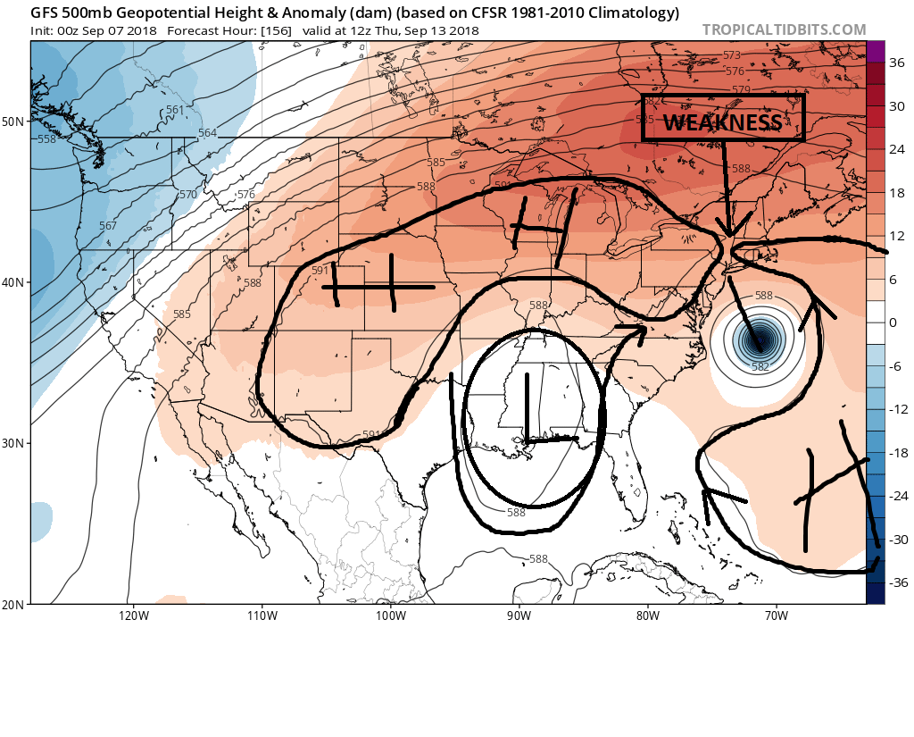
Here is the GFS. Both maps below will be valid for the same time stamps of 12z this upcoming Thursday. The first map however was the 00z run from Sept 7th. Notice the ridge and trough configuration. There is an upper level low, actually more like an open trough centered along the gulf coast states. Notice there is a weakness over the NE. The eastern flank of the trough over the Gulf states proves the system a net steering component to the N and NE. Combine that with the weakness to the HP ridge and this system gained northern latitude and eventually recurved OTS on this particular model run.
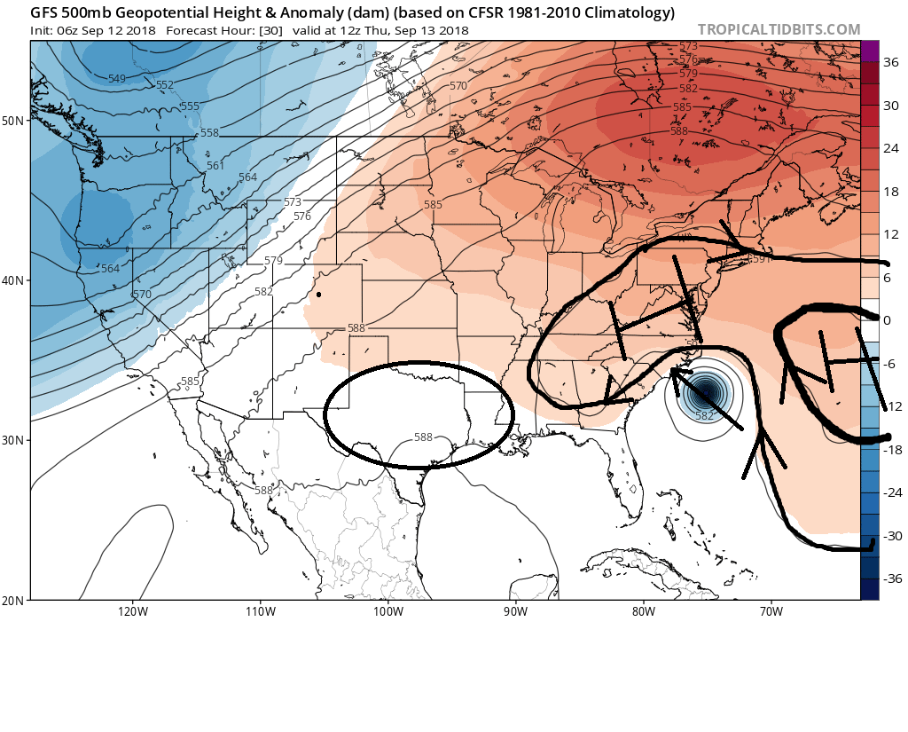
But now take a look at the second image below. This was from this am's 06z GFS run again valid for 12z this Thursday. Now take notice the upper level feature configuration. The upper level trough or low that was prev centered over the gulf states is much weaker and further SW centered over Tx/N Mexico/NW GOM and the Ridge is much more stout to the north of our system. The net steering flow now is NW(when you combine the N steering component to Florence's east and the westerly component of the ridge to its north and northwest).
Now lets shift over the euro maps beginning with the same time frame of Thursday 12z tomorrow. The upper level pattern has evolved in the modeling into what we see below.
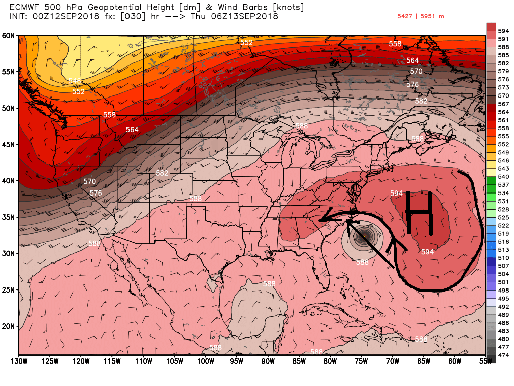
Like in Levi Cowins video I posted below as Florence approaches the coast the Atlantic ridge begins to decay while a ridge to her west begins to strengthen. The ridge to the east wants to steer her N, while the ridge to the west wants to steer her south. The net result is they cancel each other out and she stalls for a period. Now the reason why the Atlantic ridging is decaying is due to a small upper level trough dropping south as seen in the upper R edge of the picture due east of cape cod or south of Nova Scotia. And the reason the ridge to the west is building is likely due to the latent heat release from the trough In the WNW GOM(which is likely the tropical wave the NHC has marked for possible development just N of the Yucatan Peninsula. (https://www.nhc.noaa.gov/)

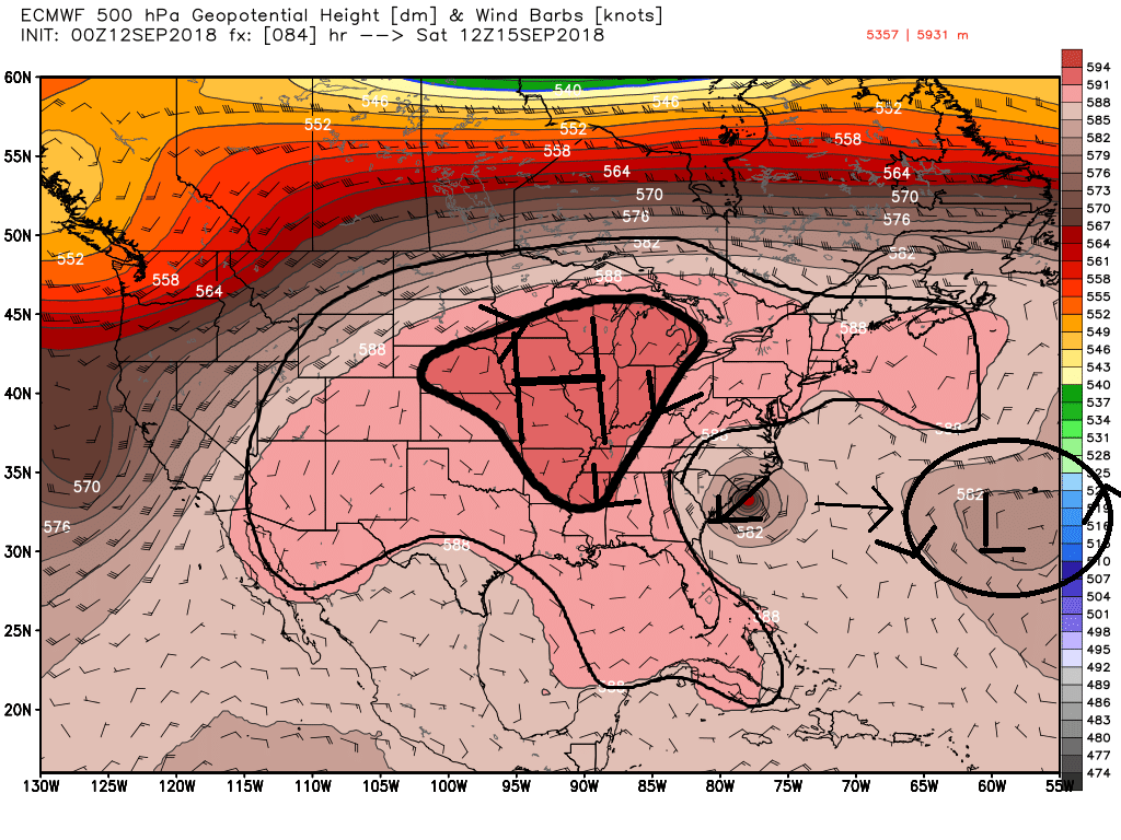
Now follow along with the next several images. while there is a small force tugging on the system from the upper level Lo out in the Atlantic, the dominant steering mechanism is compliments of the Ridge to the west and a movement to the SW ensues until the ridge positions itself to the N. By this time the steering flow shifts to the west and she finally moves inland for a period. All the while a weakness is developing in the ridge over the central CONUS. Finally when the ridge shifts into the NE and back over the Atlantic Flo really begins to feel the effects of the incoming trough and she heads towards the weakness. Again net steering finally turns her N. until she is picked up by the westerlies of the Jet stream.
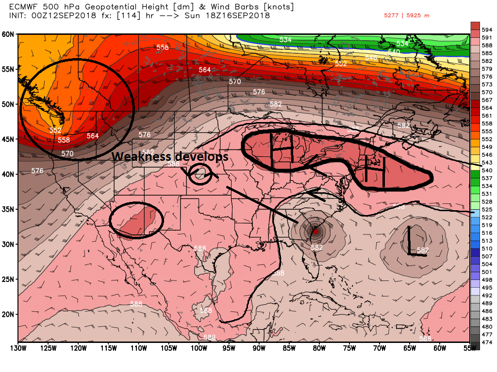


There is still some uncertainty in timing, strength, and positioning to some of the upper level features involved in steering Florence once she reaches the NC coastline, so subtle shifts in track are still likely in the 2-5day forecasts
You may have seen gifs of model runs or simply following the model runs yourself as they come out scratching your head at what your seeing regarding the track over the past 24hrs. Models are in good agreement and are now are showing this crazy track where she first tracks NW towards the Carolina coast in a "Traditional" fashion. As she approaches the coast she stalls either just before, or right on the coast; then after sitting for a bit begins to drift SW ward along the coast before eventually coming inland, then finally turns north and eventually turns NE.
Ive heard people in here and in other boards making comments about how unique this is or its unprecedented if it happens blah blah. While the exact track, if this occurs may be unique and the devastation to the Carolina coast line would be unprecedented, a track that has a tropical system stall, do loops before eventually being picked up by the westerlies and steered OTS is anything but unique. It has happened many times before and will happen again.
Here it is layed out. 500mb is the main steering layer so I will keep the discussion at this level only.
Here is the GFS. Both maps below will be valid for the same time stamps of 12z this upcoming Thursday. The first map however was the 00z run from Sept 7th. Notice the ridge and trough configuration. There is an upper level low, actually more like an open trough centered along the gulf coast states. Notice there is a weakness over the NE. The eastern flank of the trough over the Gulf states proves the system a net steering component to the N and NE. Combine that with the weakness to the HP ridge and this system gained northern latitude and eventually recurved OTS on this particular model run.
But now take a look at the second image below. This was from this am's 06z GFS run again valid for 12z this Thursday. Now take notice the upper level feature configuration. The upper level trough or low that was prev centered over the gulf states is much weaker and further SW centered over Tx/N Mexico/NW GOM and the Ridge is much more stout to the north of our system. The net steering flow now is NW(when you combine the N steering component to Florence's east and the westerly component of the ridge to its north and northwest).


Now lets shift over the euro maps beginning with the same time frame of Thursday 12z tomorrow. The upper level pattern has evolved in the modeling into what we see below.

Like in Levi Cowins video I posted below as Florence approaches the coast the Atlantic ridge begins to decay while a ridge to her west begins to strengthen. The ridge to the east wants to steer her N, while the ridge to the west wants to steer her south. The net result is they cancel each other out and she stalls for a period. Now the reason why the Atlantic ridging is decaying is due to a small upper level trough dropping south as seen in the upper R edge of the picture due east of cape cod or south of Nova Scotia. And the reason the ridge to the west is building is likely due to the latent heat release from the trough In the WNW GOM(which is likely the tropical wave the NHC has marked for possible development just N of the Yucatan Peninsula. (https://www.nhc.noaa.gov/)

Now follow along with the next several images. while there is a small force tugging on the system from the upper level Lo out in the Atlantic, the dominant steering mechanism is compliments of the Ridge to the west and a movement to the SW ensues until the ridge positions itself to the N. By this time the steering flow shifts to the west and she finally moves inland for a period. All the while a weakness is developing in the ridge over the central CONUS. Finally when the ridge shifts into the NE and back over the Atlantic Flo really begins to feel the effects of the incoming trough and she heads towards the weakness. Again net steering finally turns her N. until she is picked up by the westerlies of the Jet stream.


There is still some uncertainty in timing, strength, and positioning to some of the upper level features involved in steering Florence once she reaches the NC coastline, so subtle shifts in track are still likely in the 2-5day forecasts
_________________
"In weather and in life, there's no winning and losing; there's only winning and learning."
WINTER 2012/2013 TOTALS 43.65"WINTER 2017/2018 TOTALS 62.85" WINTER 2022/2023 TOTALS 4.9"
WINTER 2013/2014 TOTALS 64.85"WINTER 2018/2019 TOTALS 14.25" WINTER 2023/2024 TOTALS 13.1"
WINTER 2014/2015 TOTALS 71.20"WINTER 2019/2020 TOTALS 6.35"
WINTER 2015/2016 TOTALS 35.00"WINTER 2020/2021 TOTALS 37.75"
WINTER 2016/2017 TOTALS 42.25"WINTER 2021/2022 TOTALS 31.65"

sroc4- Admin

- Posts : 8354
Reputation : 302
Join date : 2013-01-07
Location : Wading River, LI
 Re: MAJOR HURRICANE FLORENCE part 2: Will have historic impacts to the Carolina coastline and areas inland
Scott great analysis as always. It will be amazing to watch this unfold the next several days. The best outcome for those living in the Carolinas would be if she stalls Over land and weakens rapidly but that is yet to be seen. Also for those who are a little less experienced with upper-level Dynamics you could see that Florence is relatively small in the grand scale of things. So even though she is powerful she is influenced by these features. this is why she cannot move wherever she wants. She can wobble 50 or a hundred miles north or south or break through weaknesses in these upper level features but she has no choice but to be steered by them. Very interesting storm to track

algae888- Advanced Forecaster

- Posts : 5311
Reputation : 46
Join date : 2013-02-05
Age : 62
Location : mt. vernon, new york
 Re: MAJOR HURRICANE FLORENCE part 2: Will have historic impacts to the Carolina coastline and areas inland
algae888 wrote:Scott great analysis as always. It will be amazing to watch this unfold the next several days. The best outcome for those living in the Carolinas would be if she stalls Over land and weakens rapidly but that is yet to be seen. Also for those who are a little less experienced with upper-level Dynamics you could see that Florence is relatively small in the grand scale of things. So even though she is powerful she is influenced by these features. this is why she cannot move wherever she wants. She can wobble 50 or a hundred miles north or south or break through weaknesses in these upper level features but she has no choice but to be steered by them. Very interesting storm to track
Thanks Scott. Lots of factors in the scenarios. Fascinating Just hope damaged is minimized

Grselig- Senior Enthusiast

- Posts : 1408
Reputation : 140
Join date : 2013-03-04
Age : 54
Location : Wayne NJ
 Re: MAJOR HURRICANE FLORENCE part 2: Will have historic impacts to the Carolina coastline and areas inland
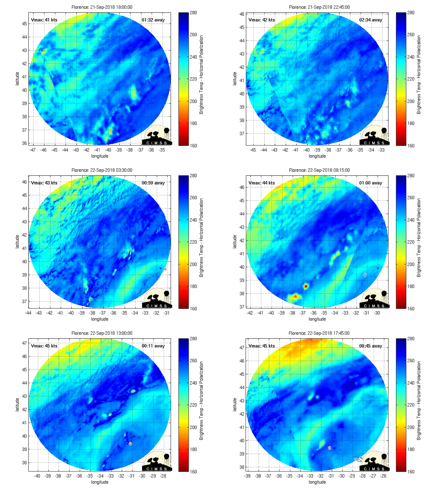
She is in the process of another ERC (eye wall replacement cycle). This might slow development or even weaken her briefly, but usually this is an indication of overall strengthening. This is microwave imagery over the past 24hrs. You can see at the beginning of the loop the ERC from yesterday complete itself, followed by a much larger ring beginning to take shape at the end of the loop. Impressive to say the least.

_________________
"In weather and in life, there's no winning and losing; there's only winning and learning."
WINTER 2012/2013 TOTALS 43.65"WINTER 2017/2018 TOTALS 62.85" WINTER 2022/2023 TOTALS 4.9"
WINTER 2013/2014 TOTALS 64.85"WINTER 2018/2019 TOTALS 14.25" WINTER 2023/2024 TOTALS 13.1"
WINTER 2014/2015 TOTALS 71.20"WINTER 2019/2020 TOTALS 6.35"
WINTER 2015/2016 TOTALS 35.00"WINTER 2020/2021 TOTALS 37.75"
WINTER 2016/2017 TOTALS 42.25"WINTER 2021/2022 TOTALS 31.65"

sroc4- Admin

- Posts : 8354
Reputation : 302
Join date : 2013-01-07
Location : Wading River, LI
 Re: MAJOR HURRICANE FLORENCE part 2: Will have historic impacts to the Carolina coastline and areas inland
Being perfectly honest here. The kind of flooding that would take place in parts of NC and SC are such that there will likely be areas that are completely reshaped. If the stall does happen and the storm meanders off the coast for 24-36 hours, some areas will likely be looking at 30+ or 40+ inches of rain. With nowhere for that water to go due to the storm surge. Also through several tide cycles.
Before and after pictures are going to be awe inspiring if this happens.
Before and after pictures are going to be awe inspiring if this happens.

bobjohnsonforthehall- Posts : 311
Reputation : 19
Join date : 2016-10-02
Location : Flemington NJ
 Re: MAJOR HURRICANE FLORENCE part 2: Will have historic impacts to the Carolina coastline and areas inland
Cone chaged a bit keeps her just offshore parallel coast ona SW track, so weird. also direction has changed a little now moving NW, might come in a little further north if she stays NW all the way.

jmanley32- Senior Enthusiast

- Posts : 20535
Reputation : 108
Join date : 2013-12-12
Age : 43
Location : Yonkers, NY
 Re: MAJOR HURRICANE FLORENCE part 2: Will have historic impacts to the Carolina coastline and areas inland
Here was my post comparing the EURO vs GFS with Flor a few days ago. Looks like EURO is going to come out on top, successfully predicting Flor's eventual path.
Frank_Wx wrote:I think Flor's intensity has been the difference maker to this point. Check out the GFS from yesterday morning. According to Tidbits she was located at about 29.35 N longitude 12z Monday.
24 hours later the GFS now has Flor located 25.68 N longitude 12z Monday.
Her rapid strengthening a couple of days ago has helped her stay further south, thus avoiding the trough to her north. Instead a High Pressure builds to her north and she is forced to stay in a W-NW path.
Now it's a matter of understanding how the pattern chooses to set itself up downstream. That will determine how far north Flor gets and if she decides to make direct landfall or re-curve OTS.
The EURO has landfall into the Carolinas. It seems to be the most southern solution. The EURO has a strong High building over the Northeast which aids in keeping Flor to our south.
The GFS meanwhile has that same High located near the Hudson Bay in Canada. WELL N&W from where the EURO has it. For the same time period by the way. These are significant differences. If the GFS is correct then Flor has a shot of reaching our longitude but could also re-curve OTS, while the EURO would keep the impacts confined well to our south with very little wiggle room for a re-curve OTS.
We'll see how it all plays out. Fun times!
_________________
_______________________________________________________________________________________________________
CLICK HERE to view NJ Strong Snowstorm Classifications
 Re: MAJOR HURRICANE FLORENCE part 2: Will have historic impacts to the Carolina coastline and areas inland
bobjohnsonforthehall wrote:Being perfectly honest here. The kind of flooding that would take place in parts of NC and SC are such that there will likely be areas that are completely reshaped. If the stall does happen and the storm meanders off the coast for 24-36 hours, some areas will likely be looking at 30+ or 40+ inches of rain. With nowhere for that water to go due to the storm surge. Also through several tide cycles.
Before and after pictures are going to be awe inspiring if this happens.
Another thing to point out is that there are no less that 12 nuclear power plants in Flo's path 2 are looking at a possible direct impact.
Also NC is home to the largest pig farms in the country, the sewerage produced by these farms is unreal, (A large pork farmer just shelled out $25MM in a law suit by it's neighbor) a flood will cause this contaminated waste to reek havoc in surrounding areas.

Joe Snow- Pro Enthusiast

- Posts : 924
Reputation : 7
Join date : 2014-02-12
Age : 62
Location : Sanford Florida, Fmrly Kings Park, NY
 Re: MAJOR HURRICANE FLORENCE part 2: Will have historic impacts to the Carolina coastline and areas inland
Joe Snow wrote:bobjohnsonforthehall wrote:Being perfectly honest here. The kind of flooding that would take place in parts of NC and SC are such that there will likely be areas that are completely reshaped. If the stall does happen and the storm meanders off the coast for 24-36 hours, some areas will likely be looking at 30+ or 40+ inches of rain. With nowhere for that water to go due to the storm surge. Also through several tide cycles.
Before and after pictures are going to be awe inspiring if this happens.
Another thing to point out is that there are no less that 12 nuclear power plants in Flo's path 2 are looking at a possible direct impact.
Also NC is home to the largest pig farms in the country, the sewerage produced by these farms is unreal, (A large pork farmer just shelled out $25MM in a law suit by it's neighbor) a flood will cause this contaminated waste to reek havoc in surrounding areas.
HOLY CRAP!!!
Sorry. Couldn't resist.

bobjohnsonforthehall- Posts : 311
Reputation : 19
Join date : 2016-10-02
Location : Flemington NJ
 Re: MAJOR HURRICANE FLORENCE part 2: Will have historic impacts to the Carolina coastline and areas inland
https://www.surfline.com/surf-reports-forecasts-cams-map/@33.23409295522519,-79.08233642578126,8z
https://www.earthcam.com/events/extremeweather/
https://explore.org/livecams/frying-pan/frying-pan-cam
web cams for nc
https://www.earthcam.com/events/extremeweather/
https://explore.org/livecams/frying-pan/frying-pan-cam
web cams for nc

weatherwatchermom- Senior Enthusiast

- Posts : 3793
Reputation : 78
Join date : 2014-11-25
Location : Hazlet Township, NJ
 Re: MAJOR HURRICANE FLORENCE part 2: Will have historic impacts to the Carolina coastline and areas inland
bobjohnsonforthehall wrote:Joe Snow wrote:bobjohnsonforthehall wrote:Being perfectly honest here. The kind of flooding that would take place in parts of NC and SC are such that there will likely be areas that are completely reshaped. If the stall does happen and the storm meanders off the coast for 24-36 hours, some areas will likely be looking at 30+ or 40+ inches of rain. With nowhere for that water to go due to the storm surge. Also through several tide cycles.
Before and after pictures are going to be awe inspiring if this happens.
Another thing to point out is that there are no less that 12 nuclear power plants in Flo's path 2 are looking at a possible direct impact.
Also NC is home to the largest pig farms in the country, the sewerage produced by these farms is unreal, (A large pork farmer just shelled out $25MM in a law suit by it's neighbor) a flood will cause this contaminated waste to reek havoc in surrounding areas.
HOLY CRAP!!!
Sorry. Couldn't resist.
Nuclear plants, exploding pigs. I get the feeling it might be the end of the world as we know it. If it were me, I'd get myself one of these swine and start making bacon and ribs. Last meal ought to be a tasty one.

Grselig- Senior Enthusiast

- Posts : 1408
Reputation : 140
Join date : 2013-03-04
Age : 54
Location : Wayne NJ
 Re: MAJOR HURRICANE FLORENCE part 2: Will have historic impacts to the Carolina coastline and areas inland
Flo has weakened forther but wind field has expanded, down to Cat 3 125mph winds. Will she continue to decrease? The carolinas can only hope that will at least lessen wind impacts.

jmanley32- Senior Enthusiast

- Posts : 20535
Reputation : 108
Join date : 2013-12-12
Age : 43
Location : Yonkers, NY
 Re: MAJOR HURRICANE FLORENCE part 2: Will have historic impacts to the Carolina coastline and areas inland
Exploding pics lol, sorry that was funny.Grselig wrote:bobjohnsonforthehall wrote:Joe Snow wrote:bobjohnsonforthehall wrote:Being perfectly honest here. The kind of flooding that would take place in parts of NC and SC are such that there will likely be areas that are completely reshaped. If the stall does happen and the storm meanders off the coast for 24-36 hours, some areas will likely be looking at 30+ or 40+ inches of rain. With nowhere for that water to go due to the storm surge. Also through several tide cycles.
Before and after pictures are going to be awe inspiring if this happens.
Another thing to point out is that there are no less that 12 nuclear power plants in Flo's path 2 are looking at a possible direct impact.
Also NC is home to the largest pig farms in the country, the sewerage produced by these farms is unreal, (A large pork farmer just shelled out $25MM in a law suit by it's neighbor) a flood will cause this contaminated waste to reek havoc in surrounding areas.
HOLY CRAP!!!
Sorry. Couldn't resist.
Nuclear plants, exploding pigs. I get the feeling it might be the end of the world as we know it. If it were me, I'd get myself one of these swine and start making bacon and ribs. Last meal ought to be a tasty one.

jmanley32- Senior Enthusiast

- Posts : 20535
Reputation : 108
Join date : 2013-12-12
Age : 43
Location : Yonkers, NY
 Re: MAJOR HURRICANE FLORENCE part 2: Will have historic impacts to the Carolina coastline and areas inland
surprisingly calm waters for how much closer flo is getting.weatherwatchermom wrote:https://www.surfline.com/surf-reports-forecasts-cams-map/@33.23409295522519,-79.08233642578126,8z
https://www.earthcam.com/events/extremeweather/
https://explore.org/livecams/frying-pan/frying-pan-cam
web cams for nc

jmanley32- Senior Enthusiast

- Posts : 20535
Reputation : 108
Join date : 2013-12-12
Age : 43
Location : Yonkers, NY
 Re: MAJOR HURRICANE FLORENCE part 2: Will have historic impacts to the Carolina coastline and areas inland
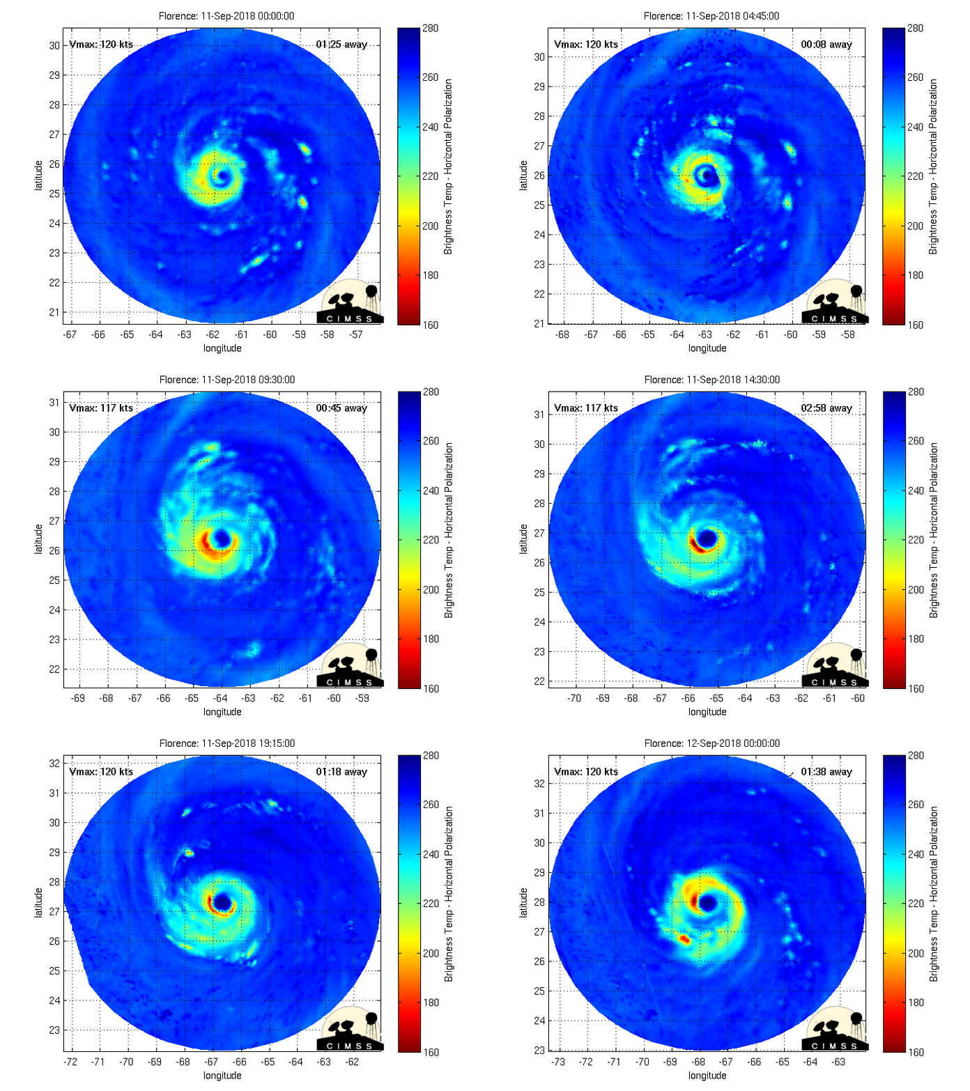
jmanley32 wrote:Flo has weakened forther but wind field has expanded, down to Cat 3 125mph winds. Will she continue to decrease? The carolinas can only hope that will at least lessen wind impacts.
Shes undergoing an eye wall replacement cycle. Weakening during these events is expected. She will likely re intensify as soon as its complete. Notice the last few seconds of the loop the eye wall looks like its going to double in diameter. Unfortunately there should be just enough time before she reaches the continental shelf to complete the ERC and re-intensify before landfall.
_________________
"In weather and in life, there's no winning and losing; there's only winning and learning."
WINTER 2012/2013 TOTALS 43.65"WINTER 2017/2018 TOTALS 62.85" WINTER 2022/2023 TOTALS 4.9"
WINTER 2013/2014 TOTALS 64.85"WINTER 2018/2019 TOTALS 14.25" WINTER 2023/2024 TOTALS 13.1"
WINTER 2014/2015 TOTALS 71.20"WINTER 2019/2020 TOTALS 6.35"
WINTER 2015/2016 TOTALS 35.00"WINTER 2020/2021 TOTALS 37.75"
WINTER 2016/2017 TOTALS 42.25"WINTER 2021/2022 TOTALS 31.65"

sroc4- Admin

- Posts : 8354
Reputation : 302
Join date : 2013-01-07
Location : Wading River, LI
 Re: MAJOR HURRICANE FLORENCE part 2: Will have historic impacts to the Carolina coastline and areas inland
The latest official forecast is for the storm to weaken to maybe even below major status and then move sw along the coast while.continuing to weaken as it moves inshore into SC. Can you imagine if this thing peters out and winds up being not a huge deal. People will freak out
Guest- Guest
 Re: MAJOR HURRICANE FLORENCE part 2: Will have historic impacts to the Carolina coastline and areas inland
If that happens, I'll freak out in joy. My daughter lives in Columbia and I've been a nervous wreck for a while now.
Guest- Guest
 Re: MAJOR HURRICANE FLORENCE part 2: Will have historic impacts to the Carolina coastline and areas inland
There’d never been anything to worry about for Columbia SC. At worst they get 4-8” of rain and 55mph winds.
Guest- Guest
 Re: MAJOR HURRICANE FLORENCE part 2: Will have historic impacts to the Carolina coastline and areas inland
syosnow94 wrote:The latest official forecast is for the storm to weaken to maybe even below major status and then move sw along the coast while.continuing to weaken as it moves inshore into SC. Can you imagine if this thing peters out and winds up being not a huge deal. People will freak out
I think this is a simplified statement that isnt that accurate. It comes into the coast as a major hurricane; then takes about 24hrs before down graded to a hurricane of Cat 2 or less. The next 24hrs the same locations cont to be battered by wind and massive amounts of rain as she slowly drifts SSW

_________________
"In weather and in life, there's no winning and losing; there's only winning and learning."
WINTER 2012/2013 TOTALS 43.65"WINTER 2017/2018 TOTALS 62.85" WINTER 2022/2023 TOTALS 4.9"
WINTER 2013/2014 TOTALS 64.85"WINTER 2018/2019 TOTALS 14.25" WINTER 2023/2024 TOTALS 13.1"
WINTER 2014/2015 TOTALS 71.20"WINTER 2019/2020 TOTALS 6.35"
WINTER 2015/2016 TOTALS 35.00"WINTER 2020/2021 TOTALS 37.75"
WINTER 2016/2017 TOTALS 42.25"WINTER 2021/2022 TOTALS 31.65"

sroc4- Admin

- Posts : 8354
Reputation : 302
Join date : 2013-01-07
Location : Wading River, LI
 Re: MAJOR HURRICANE FLORENCE part 2: Will have historic impacts to the Carolina coastline and areas inland
We will see Scott
If you watch the satellite closely she looks to be moving nnw instead of nw. If this doesn’t change it would move up into the northeastern most part of NC. Probably just a wobble.
If you watch the satellite closely she looks to be moving nnw instead of nw. If this doesn’t change it would move up into the northeastern most part of NC. Probably just a wobble.
Guest- Guest
 Re: MAJOR HURRICANE FLORENCE part 2: Will have historic impacts to the Carolina coastline and areas inland
syosnow94 wrote:We will see Scott
If you watch the satellite closely she looks to be moving nnw instead of nw. If this doesn’t change it would move up into the northeastern most part of NC. Probably just a wobble.
Totally agree on the track Jim. Its current path is def Nw to NNW and its been like that all day. If you draw a straight line to the coast on its current track it hits the outerbanks. If it doesnt shift WNW soon it could track north of the current concensus.
_________________
"In weather and in life, there's no winning and losing; there's only winning and learning."
WINTER 2012/2013 TOTALS 43.65"WINTER 2017/2018 TOTALS 62.85" WINTER 2022/2023 TOTALS 4.9"
WINTER 2013/2014 TOTALS 64.85"WINTER 2018/2019 TOTALS 14.25" WINTER 2023/2024 TOTALS 13.1"
WINTER 2014/2015 TOTALS 71.20"WINTER 2019/2020 TOTALS 6.35"
WINTER 2015/2016 TOTALS 35.00"WINTER 2020/2021 TOTALS 37.75"
WINTER 2016/2017 TOTALS 42.25"WINTER 2021/2022 TOTALS 31.65"

sroc4- Admin

- Posts : 8354
Reputation : 302
Join date : 2013-01-07
Location : Wading River, LI
 Re: MAJOR HURRICANE FLORENCE part 2: Will have historic impacts to the Carolina coastline and areas inland
https://www.tropicaltidbits.com/sat/satlooper.php?region=nwatl&product=truecolor
_________________
"In weather and in life, there's no winning and losing; there's only winning and learning."
WINTER 2012/2013 TOTALS 43.65"WINTER 2017/2018 TOTALS 62.85" WINTER 2022/2023 TOTALS 4.9"
WINTER 2013/2014 TOTALS 64.85"WINTER 2018/2019 TOTALS 14.25" WINTER 2023/2024 TOTALS 13.1"
WINTER 2014/2015 TOTALS 71.20"WINTER 2019/2020 TOTALS 6.35"
WINTER 2015/2016 TOTALS 35.00"WINTER 2020/2021 TOTALS 37.75"
WINTER 2016/2017 TOTALS 42.25"WINTER 2021/2022 TOTALS 31.65"

sroc4- Admin

- Posts : 8354
Reputation : 302
Join date : 2013-01-07
Location : Wading River, LI
 Re: MAJOR HURRICANE FLORENCE part 2: Will have historic impacts to the Carolina coastline and areas inland
Wow huge!!! If I were looking at this without knowing anything about the steering I would say thats hitting OBX or even VA and riding up the coast, what the upper levels can do is amazing, It hasnt happened till I see it though lolsroc4 wrote:https://www.tropicaltidbits.com/sat/satlooper.php?region=nwatl&product=truecolor

jmanley32- Senior Enthusiast

- Posts : 20535
Reputation : 108
Join date : 2013-12-12
Age : 43
Location : Yonkers, NY
 Re: MAJOR HURRICANE FLORENCE part 2: Will have historic impacts to the Carolina coastline and areas inland
NHC 5PM update:


_________________
"In weather and in life, there's no winning and losing; there's only winning and learning."
WINTER 2012/2013 TOTALS 43.65"WINTER 2017/2018 TOTALS 62.85" WINTER 2022/2023 TOTALS 4.9"
WINTER 2013/2014 TOTALS 64.85"WINTER 2018/2019 TOTALS 14.25" WINTER 2023/2024 TOTALS 13.1"
WINTER 2014/2015 TOTALS 71.20"WINTER 2019/2020 TOTALS 6.35"
WINTER 2015/2016 TOTALS 35.00"WINTER 2020/2021 TOTALS 37.75"
WINTER 2016/2017 TOTALS 42.25"WINTER 2021/2022 TOTALS 31.65"

sroc4- Admin

- Posts : 8354
Reputation : 302
Join date : 2013-01-07
Location : Wading River, LI
 Re: MAJOR HURRICANE FLORENCE part 2: Will have historic impacts to the Carolina coastline and areas inland
weatherwatchermom wrote:https://www.surfline.com/surf-reports-forecasts-cams-map/@33.23409295522519,-79.08233642578126,8z
https://www.earthcam.com/events/extremeweather/
https://explore.org/livecams/frying-pan/frying-pan-cam
web cams for nc
I wonder how long the cams will hold up, especially the frying pan cam. 34 miles off the coast of Cape Fear. The sound of the wind is something, but I don't think the flag is gonna make it. The hurricane is nowhere in sight yet there.
GreyBeard- Senior Enthusiast

- Posts : 725
Reputation : 34
Join date : 2014-02-12
Location : eastern nassau county
Page 1 of 7 • 1, 2, 3, 4, 5, 6, 7 
Permissions in this forum:
You cannot reply to topics in this forum|
|
|

 Home
Home


