MAJOR HURRICANE FLORENCE part 2: Will have historic impacts to the Carolina coastline and areas inland
+27
amugs
Radz
skinsfan1177
rb924119
billg315
WOLVES1
CentralNJ
hyde345
docstox12
mwilli5783
Snow88
Math23x7
bloc1357
oldtimer
aiannone
Dunnzoo
SoulSingMG
nutleyblizzard
GreyBeard
weatherwatchermom
Joe Snow
Frank_Wx
jmanley32
bobjohnsonforthehall
Grselig
algae888
sroc4
31 posters
Page 6 of 7 •  1, 2, 3, 4, 5, 6, 7
 Re: MAJOR HURRICANE FLORENCE part 2: Will have historic impacts to the Carolina coastline and areas inland
sroc4 wrote:rb924119 wrote:Eye spy due northward progression
Not that it's coming up here, but it gives me a chance for a couple of my ideas to have merit. We shall see. At work, so I cannot discuss deeply to what im referring, but basically my predicted landfall point as well as ideas I presented a couple days ago. Be back later!
Damn Ray You beat me to it. I wanted post that and give you kudos. Frictional forces, Convergence over land, lowering pressures...I remember
Well, thank you, Scott haha if somebody can post an animation of the microwave imagery, they can see that the ideas did prove to have merit. As Florence encountered the coastline, it actually did move northward along the coast before landfalling, and to my knowledge, NO model had shown that. This is not to brag, but instead to show how forecasters can still add a lot of value over raw model output, and how meteorology is much greater than modelology.
rb924119- Meteorologist

- Posts : 6928
Join date : 2013-02-06
 Re: MAJOR HURRICANE FLORENCE part 2: Will have historic impacts to the Carolina coastline and areas inland
Radz wrote:Reports of up to 250 rescued now and 150 more awaiting... totally agree!!weatherwatchermom wrote:WHAT THE F(excuse my language)..WHAT ABOUT MANDATORY EVACUATION DO YOU NOT UNDERSTAND!!!!!! NEW BERN IS UNDER WATER...100 PEOPLE HAVE BEEN RESCUED AND AT LEAST 100 MORE CALLS PENDING..People on roof of homes people trapped in cars...New Bern floods on a regular basis....there are 70 plus mph winds they are saying and some parts have already gotten 20 plus inches of rain and worst yet to come...what is wrong with people....I do not have sympathy.... And if rescuers are hurt because of you you should be arrested and if you knew me personally you would be shocked i feel this way....ridiculous!!!! If you can not afford to leave for hotel. Find a god darn shelter....you were warned...ughhh rant over..
The Mets and media warned everyone. There is literally no excuse. Evacuations began on Monday. That's how confident they were this storm will come. You can't fix stupid. I hope they're rescued, but if conditions for rescuers become dangerous, then what are they to do?
 Re: MAJOR HURRICANE FLORENCE part 2: Will have historic impacts to the Carolina coastline and areas inland
The slow nature of this storn will cause Cat 4 or Cat 5 type damage even though it is a Cat 2


_________________
_______________________________________________________________________________________________________
CLICK HERE to view NJ Strong Snowstorm Classifications
 Re: MAJOR HURRICANE FLORENCE part 2: Will have historic impacts to the Carolina coastline and areas inland
syosnow94 wrote:sroc4 wrote:weatherwatchermom wrote:Sorry for my bad Lang i was so upset..don't usually curse..and now a family that is in attic because water up to chest in house
Darwin’s theory of evolution at its finest. Unfort
Exactly the line I use when speaking to my students about stuff we talk about in the news. I SWEAR TO GOD IF I WAS IN CHARGE DOWN THERE I WOULD NOT SEND HELP
I concur - people even on Ocracoke Island 200 from reports did not evacuate and the town officials said sorry no help is coming if you call - right call. No one EVER believe in MOTHER NATURES FURY!
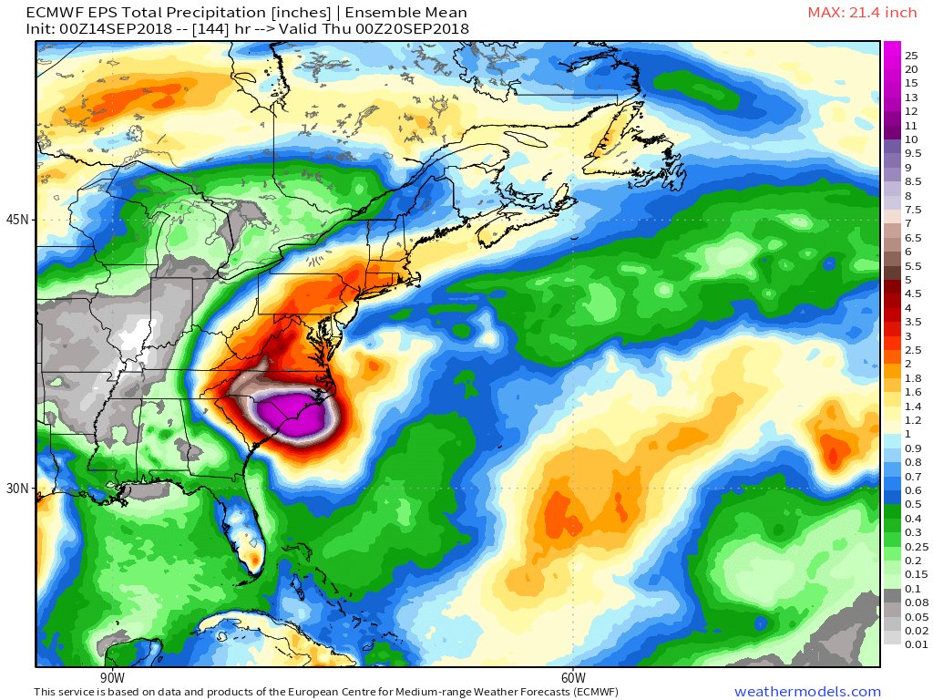
here are our effects next week - rain and a good amount:
_________________
Mugs
AKA:King: Snow Weenie
Self Proclaimed
WINTER 2014-15 : 55.12" +.02 for 6 coatings (avg. 35")
WINTER 2015-16 Total - 29.8" (Avg 35")
WINTER 2016-17 : 39.5" so far

amugs- Advanced Forecaster - Mod

- Posts : 15095
Reputation : 213
Join date : 2013-01-07
Age : 54
Location : Hillsdale,NJ
 Re: MAJOR HURRICANE FLORENCE part 2: Will have historic impacts to the Carolina coastline and areas inland
rb924119 wrote:sroc4 wrote:rb924119 wrote:Eye spy due northward progression
Not that it's coming up here, but it gives me a chance for a couple of my ideas to have merit. We shall see. At work, so I cannot discuss deeply to what im referring, but basically my predicted landfall point as well as ideas I presented a couple days ago. Be back later!
Damn Ray You beat me to it. I wanted post that and give you kudos. Frictional forces, Convergence over land, lowering pressures...I remember
Well, thank you, Scott haha if somebody can post an animation of the microwave imagery, they can see that the ideas did prove to have merit. As Florence encountered the coastline, it actually did move northward along the coast before landfalling, and to my knowledge, NO model had shown that. This is not to brag, but instead to show how forecasters can still add a lot of value over raw model output, and how meteorology is much greater than modelology.
Here you go. Clearly visible on the Microwave. Last 48hr loop

_________________
"In weather and in life, there's no winning and losing; there's only winning and learning."
WINTER 2012/2013 TOTALS 43.65"WINTER 2017/2018 TOTALS 62.85" WINTER 2022/2023 TOTALS 4.9"
WINTER 2013/2014 TOTALS 64.85"WINTER 2018/2019 TOTALS 14.25" WINTER 2023/2024 TOTALS 13.1"
WINTER 2014/2015 TOTALS 71.20"WINTER 2019/2020 TOTALS 6.35"
WINTER 2015/2016 TOTALS 35.00"WINTER 2020/2021 TOTALS 37.75"
WINTER 2016/2017 TOTALS 42.25"WINTER 2021/2022 TOTALS 31.65"

sroc4- Admin

- Posts : 8354
Reputation : 302
Join date : 2013-01-07
Location : Wading River, LI
 Re: MAJOR HURRICANE FLORENCE part 2: Will have historic impacts to the Carolina coastline and areas inland

_________________
"In weather and in life, there's no winning and losing; there's only winning and learning."
WINTER 2012/2013 TOTALS 43.65"WINTER 2017/2018 TOTALS 62.85" WINTER 2022/2023 TOTALS 4.9"
WINTER 2013/2014 TOTALS 64.85"WINTER 2018/2019 TOTALS 14.25" WINTER 2023/2024 TOTALS 13.1"
WINTER 2014/2015 TOTALS 71.20"WINTER 2019/2020 TOTALS 6.35"
WINTER 2015/2016 TOTALS 35.00"WINTER 2020/2021 TOTALS 37.75"
WINTER 2016/2017 TOTALS 42.25"WINTER 2021/2022 TOTALS 31.65"

sroc4- Admin

- Posts : 8354
Reputation : 302
Join date : 2013-01-07
Location : Wading River, LI
 Re: MAJOR HURRICANE FLORENCE part 2: Will have historic impacts to the Carolina coastline and areas inland
The radar loop is so mesmerizingly beautiful I can’t stop watching
Guest- Guest
 Re: MAJOR HURRICANE FLORENCE part 2: Will have historic impacts to the Carolina coastline and areas inland
_________________
"In weather and in life, there's no winning and losing; there's only winning and learning."
WINTER 2012/2013 TOTALS 43.65"WINTER 2017/2018 TOTALS 62.85" WINTER 2022/2023 TOTALS 4.9"
WINTER 2013/2014 TOTALS 64.85"WINTER 2018/2019 TOTALS 14.25" WINTER 2023/2024 TOTALS 13.1"
WINTER 2014/2015 TOTALS 71.20"WINTER 2019/2020 TOTALS 6.35"
WINTER 2015/2016 TOTALS 35.00"WINTER 2020/2021 TOTALS 37.75"
WINTER 2016/2017 TOTALS 42.25"WINTER 2021/2022 TOTALS 31.65"

sroc4- Admin

- Posts : 8354
Reputation : 302
Join date : 2013-01-07
Location : Wading River, LI
 Re: MAJOR HURRICANE FLORENCE part 2: Will have historic impacts to the Carolina coastline and areas inland
Reading some of the local NWS a statements out of NC, many are expected to crest between 12-20 feet ABOVE flood stage come early next week OUCH
Guest- Guest
 Re: MAJOR HURRICANE FLORENCE part 2: Will have historic impacts to the Carolina coastline and areas inland
They use tipping buckets and are affected by the wind, causing artificially higher rainfall amounts.

moleson- Posts : 32
Reputation : 0
Join date : 2013-01-07
 Re: MAJOR HURRICANE FLORENCE part 2: Will have historic impacts to the Carolina coastline and areas inland
moleson wrote:They use tipping buckets and are affected by the wind, causing artificially higher rainfall amounts.
Interesting
_________________
"In weather and in life, there's no winning and losing; there's only winning and learning."
WINTER 2012/2013 TOTALS 43.65"WINTER 2017/2018 TOTALS 62.85" WINTER 2022/2023 TOTALS 4.9"
WINTER 2013/2014 TOTALS 64.85"WINTER 2018/2019 TOTALS 14.25" WINTER 2023/2024 TOTALS 13.1"
WINTER 2014/2015 TOTALS 71.20"WINTER 2019/2020 TOTALS 6.35"
WINTER 2015/2016 TOTALS 35.00"WINTER 2020/2021 TOTALS 37.75"
WINTER 2016/2017 TOTALS 42.25"WINTER 2021/2022 TOTALS 31.65"

sroc4- Admin

- Posts : 8354
Reputation : 302
Join date : 2013-01-07
Location : Wading River, LI
 Re: MAJOR HURRICANE FLORENCE part 2: Will have historic impacts to the Carolina coastline and areas inland
sroc4 wrote:moleson wrote:They use tipping buckets and are affected by the wind, causing artificially higher rainfall amounts.
Interesting
That said lets say 12" or 1 foot of that 35" rain total is artifcat due to wind interference..that still means approx 2 feet of rain have fallen with much more to go. Still incredible.
_________________
"In weather and in life, there's no winning and losing; there's only winning and learning."
WINTER 2012/2013 TOTALS 43.65"WINTER 2017/2018 TOTALS 62.85" WINTER 2022/2023 TOTALS 4.9"
WINTER 2013/2014 TOTALS 64.85"WINTER 2018/2019 TOTALS 14.25" WINTER 2023/2024 TOTALS 13.1"
WINTER 2014/2015 TOTALS 71.20"WINTER 2019/2020 TOTALS 6.35"
WINTER 2015/2016 TOTALS 35.00"WINTER 2020/2021 TOTALS 37.75"
WINTER 2016/2017 TOTALS 42.25"WINTER 2021/2022 TOTALS 31.65"

sroc4- Admin

- Posts : 8354
Reputation : 302
Join date : 2013-01-07
Location : Wading River, LI
 Re: MAJOR HURRICANE FLORENCE part 2: Will have historic impacts to the Carolina coastline and areas inland
sroc4 wrote:sroc4 wrote:moleson wrote:They use tipping buckets and are affected by the wind, causing artificially higher rainfall amounts.
Interesting
That said lets say 12" or 1 foot of that 35" rain total is artifcat due to wind interference..that still means approx 2 feet of rain have fallen with much more to go. Still incredible.
And it can go the other way, with wind blowing the rain sideways, you can under report rain totals....
_________________
Janet
Snowfall winter of 2023-2024 17.5"
Snowfall winter of 2022-2023 6.0"
Snowfall winter of 2021-2022 17.6" 1" sleet 2/25/22
Snowfall winter of 2020-2021 51.1"
Snowfall winter of 2019-2020 8.5"
Snowfall winter of 2018-2019 25.1"
Snowfall winter of 2017-2018 51.9"
Snowfall winter of 2016-2017 45.6"
Snowfall winter of 2015-2016 29.5"
Snowfall winter of 2014-2015 50.55"
Snowfall winter of 2013-2014 66.5"
Dunnzoo- Senior Enthusiast - Mod

- Posts : 4904
Reputation : 68
Join date : 2013-01-11
Age : 62
Location : Westwood, NJ
 Re: MAJOR HURRICANE FLORENCE part 2: Will have historic impacts to the Carolina coastline and areas inland
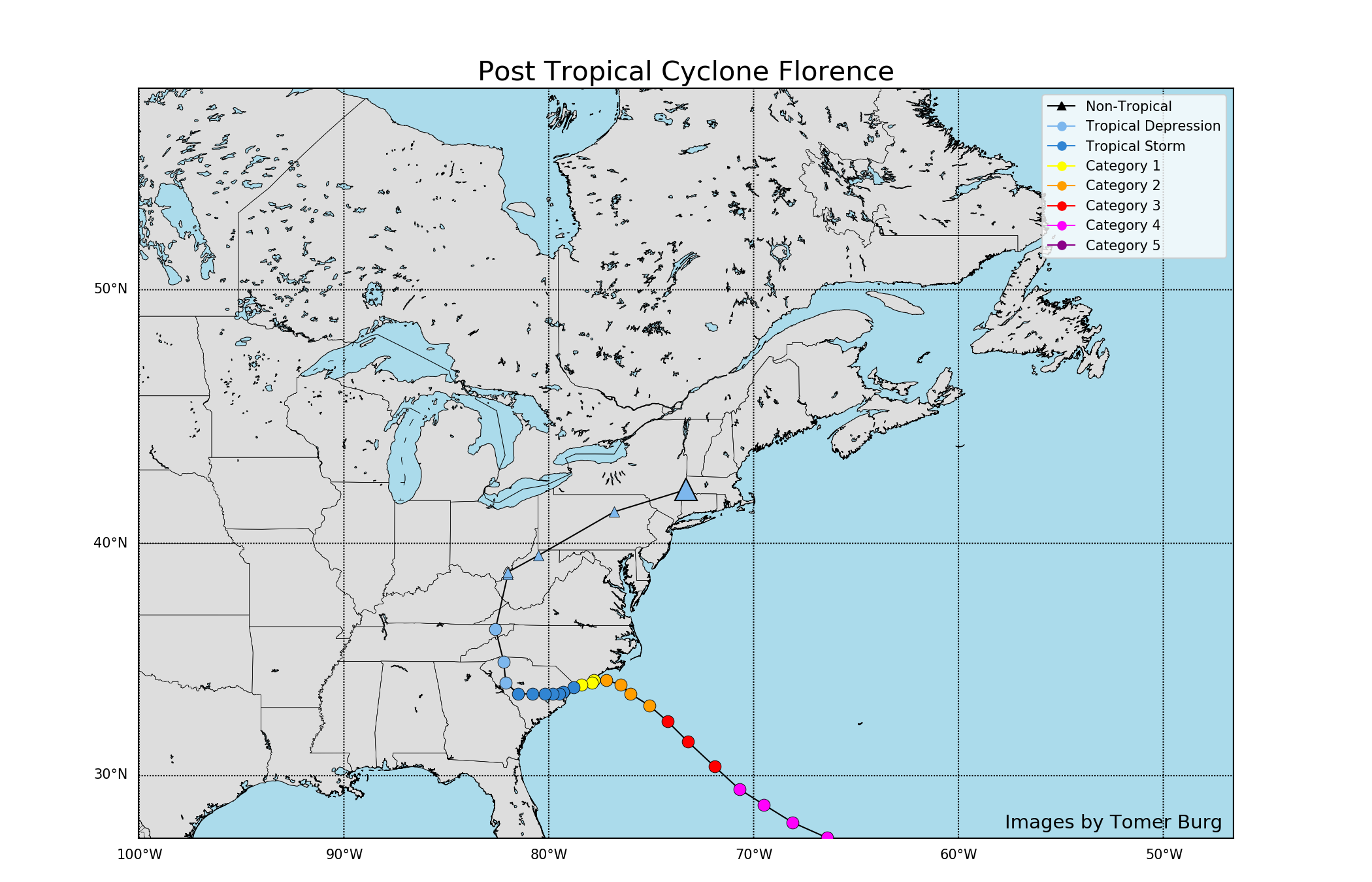
This was this mornings landfall statement by NHC.
Hurricane Florence Tropical Cyclone Update
NWS National Hurricane Center Miami FL AL062018
735 AM EDT Fri Sep 14 2018
...CENTER OF THE EYE OF HURRICANE FLORENCE FINALLY MAKES LANDFALL
NEAR WRIGHTSVILLE BEACH NORTH CAROLINA...
NOAA Doppler weather radar data and surface observations indicate
that the center of the eye of Hurricane Florence made landfall along
the coast of North Carolina at 715 AM EDT...1115 UTC...near 34.2N
77.8W...which is near Wrightsville Beach. Maximum sustained winds
were estimated to be 90 mph (150 km/h), and the central pressure was
estimated to be 958 mb based on reports from the NOAA NOS observing
station at Johnny Mercer Pier in Wrightsville Beach.
SUMMARY OF 715 AM EDT...1115 UTC...INFORMATION
----------------------------------------------
LOCATION...34.2N 77.8W
ABOUT 5 MI...10 KM E OF WILMINGTON NORTH CAROLINA
MAXIMUM SUSTAINED WINDS...90 MPH...150 KM/H
PRESENT MOVEMENT...W OR 265 DEGREES AT 6 MPH...9 KM/H
MINIMUM CENTRAL PRESSURE...958 MB...28.29 INCHES
$$
Forecaster Stewart


Quietace- Meteorologist - Mod

- Posts : 3689
Reputation : 33
Join date : 2013-01-07
Age : 27
Location : Point Pleasant, NJ
 Re: MAJOR HURRICANE FLORENCE part 2: Will have historic impacts to the Carolina coastline and areas inland
This is incorrect. TC's are actually a undersample situation due to high rainfall rates and the high winds.moleson wrote:They use tipping buckets and are affected by the wind, causing artificially higher rainfall amounts.

Quietace- Meteorologist - Mod

- Posts : 3689
Reputation : 33
Join date : 2013-01-07
Age : 27
Location : Point Pleasant, NJ
 Re: MAJOR HURRICANE FLORENCE part 2: Will have historic impacts to the Carolina coastline and areas inland
Frank_Wx wrote:The slow nature of this storn will cause Cat 4 or Cat 5 type damage even though it is a Cat 2
I couldn't agree more Frank. I thought a lot about that yesterday as the Cat status kept dropping and how that really was misleading and not a true reflection of the potential for damage and loss of life. It was a really bad time for anyone to let their guard down.
It actually got me to pondering whether there's a better way to communicate the danger and damage potential beyond just tracking categories to wind speed. Harvey and Florence were slow, grinding, rain-dumping machines. If that's a pattern we may need to come up with some kind of damage potential index that better incorporates wind speed, the surge, and the rain, with other factors like storm size, flood potential, topography and elevation, proximity to water, ground saturation, soil type, and even the kinds of homes and buildings in the area and the ability for people to escape.

essexcountypete- Pro Enthusiast

- Posts : 783
Reputation : 12
Join date : 2013-12-09
Location : Bloomfield, NJ
 Re: MAJOR HURRICANE FLORENCE part 2: Will have historic impacts to the Carolina coastline and areas inland
I don't know if you know this area..It's beautiful..shackleford island with the wild horses..the beaches...the beautiful house my parents where to buy next year is probably gone....I hope the horses are ok...they have been on island for 100's of years..
Last edited by weatherwatchermom on Fri Sep 14, 2018 12:45 pm; edited 1 time in total

weatherwatchermom- Senior Enthusiast

- Posts : 3793
Reputation : 78
Join date : 2014-11-25
Location : Hazlet Township, NJ
 Re: MAJOR HURRICANE FLORENCE part 2: Will have historic impacts to the Carolina coastline and areas inland
Mom, I read a few days ago a local official saying "Don't worry about the horses, they will be fine". I hope he is right about that.
This storm is nearly stationary, flooding will be extreme.That rain report of 35 inches earlier is mind boggling.
This storm is nearly stationary, flooding will be extreme.That rain report of 35 inches earlier is mind boggling.

docstox12- Wx Statistician Guru

- Posts : 8530
Reputation : 222
Join date : 2013-01-07
Age : 73
Location : Monroe NY
 Re: MAJOR HURRICANE FLORENCE part 2: Will have historic impacts to the Carolina coastline and areas inland
I hope so too...I see they are out evacuating people..can't stop watchingdocstox12 wrote:Mom, I read a few days ago a local official saying "Don't worry about the horses, they will be fine". I hope he is right about that.
This storm is nearly stationary, flooding will be extreme.That rain report of 35 inches earlier is mind boggling.

weatherwatchermom- Senior Enthusiast

- Posts : 3793
Reputation : 78
Join date : 2014-11-25
Location : Hazlet Township, NJ
 Re: MAJOR HURRICANE FLORENCE part 2: Will have historic impacts to the Carolina coastline and areas inland
Just west of Wilmington has been sitting under the stationary eyewall for 6 straight hours and picked up 18” of rain during that time and God knows how much wind. Holy Shit!
Guest- Guest
 Re: MAJOR HURRICANE FLORENCE part 2: Will have historic impacts to the Carolina coastline and areas inland
She's heading west, not south... SC is going to be spared the worst of it...
_________________
Janet
Snowfall winter of 2023-2024 17.5"
Snowfall winter of 2022-2023 6.0"
Snowfall winter of 2021-2022 17.6" 1" sleet 2/25/22
Snowfall winter of 2020-2021 51.1"
Snowfall winter of 2019-2020 8.5"
Snowfall winter of 2018-2019 25.1"
Snowfall winter of 2017-2018 51.9"
Snowfall winter of 2016-2017 45.6"
Snowfall winter of 2015-2016 29.5"
Snowfall winter of 2014-2015 50.55"
Snowfall winter of 2013-2014 66.5"

Dunnzoo- Senior Enthusiast - Mod

- Posts : 4904
Reputation : 68
Join date : 2013-01-11
Age : 62
Location : Westwood, NJ
 Re: MAJOR HURRICANE FLORENCE part 2: Will have historic impacts to the Carolina coastline and areas inland
HORRIBLE.....I am.watching..a man had to be extracted from his home a big tree fell on it..they had surgeons come in to possibly amputate leg or legs on scene....wife and baby DEAD......

weatherwatchermom- Senior Enthusiast

- Posts : 3793
Reputation : 78
Join date : 2014-11-25
Location : Hazlet Township, NJ
 Re: MAJOR HURRICANE FLORENCE part 2: Will have historic impacts to the Carolina coastline and areas inland
weatherwatchermom wrote:Again when they tell you to get out you do.....I am.watching..a man had to be extracted from his home a big tree fell on it..they had surgeons come in to possibly amputate leg or legs on scene....wife and baby DEAD......
wwmom,take some advise from an old man. I know it's like driving by a car wreck, and you just gotta look, but give yourself a break and step away from the tv for a while. You're gonnna make yourself crazy. Go have an adult beverage and try to relax a bit. I can feel your passion, concern and at times anger coming thru your texts. I hope all your family and friends have found safe haven.
PS-as doc said, I also saw on the news that the horses should fare well. The reporter said they knew by instinct what to do, and as you said they've been there for 100's of years so they must be doing something right

GreyBeard- Senior Enthusiast

- Posts : 725
Reputation : 34
Join date : 2014-02-12
Location : eastern nassau county
 Re: MAJOR HURRICANE FLORENCE part 2: Will have historic impacts to the Carolina coastline and areas inland
GreyBeard wrote:weatherwatchermom wrote:Again when they tell you to get out you do.....I am.watching..a man had to be extracted from his home a big tree fell on it..they had surgeons come in to possibly amputate leg or legs on scene....wife and baby DEAD......
wwmom,take some advise from an old man. I know it's like driving by a car wreck, and you just gotta look, but give yourself a break and step away from the tv for a while. You're gonnna make yourself crazy. Go have an adult beverage and try to relax a bit. I can feel your passion, concern and at times anger coming thru your texts. I hope all your family and friends have found safe haven.
PS-as doc said, I also saw on the news that the horses should fare well. The reporter said they knew by instinct what to do, and as you said they've been there for 100's of years so they must be doing something right
Ha..I did am watching netflix...I am recovering from pneumonia so I am not out and about...def turned it off...family and friends are ok.... Tx

weatherwatchermom- Senior Enthusiast

- Posts : 3793
Reputation : 78
Join date : 2014-11-25
Location : Hazlet Township, NJ
 Re: MAJOR HURRICANE FLORENCE part 2: Will have historic impacts to the Carolina coastline and areas inland
In some ways the weakening before reaching the coast was a blessing, but I wonder if the drop in (wind) strength caused anyone to let their guard down seeing it go from Cat 4 to Cat 2. I think the NHC and government did a good job of conveying that the category drop in no way diminished the potential impact of the storm surge and rains, but some people don't always listen to the details.

billg315- Advanced Forecaster - Mod

- Posts : 4483
Reputation : 185
Join date : 2015-01-24
Age : 50
Location : Flemington, NJ
 Re: MAJOR HURRICANE FLORENCE part 2: Will have historic impacts to the Carolina coastline and areas inland
Am looking at the indie eutro ensembles #6 is aweful, has her re-emerge off the midatlantic courve around and hit the same area of NC as a 985mb cane on day 10, no joke, those of you who have the ability to look its unreal, highly doubtful but jeeze.

jmanley32- Senior Enthusiast

- Posts : 20535
Reputation : 108
Join date : 2013-12-12
Age : 43
Location : Yonkers, NY
 Re: MAJOR HURRICANE FLORENCE part 2: Will have historic impacts to the Carolina coastline and areas inland
00z Euro ensembles had a slew of runs with 6+ inches of rain. I know we are concerned for the folks down south myself included but this is def something we have to watch.

jmanley32- Senior Enthusiast

- Posts : 20535
Reputation : 108
Join date : 2013-12-12
Age : 43
Location : Yonkers, NY
Page 6 of 7 •  1, 2, 3, 4, 5, 6, 7
Permissions in this forum:
You cannot reply to topics in this forum|
|
|

 Home
Home
