MAJOR HURRICANE FLORENCE part 2: Will have historic impacts to the Carolina coastline and areas inland
+27
amugs
Radz
skinsfan1177
rb924119
billg315
WOLVES1
CentralNJ
hyde345
docstox12
mwilli5783
Snow88
Math23x7
bloc1357
oldtimer
aiannone
Dunnzoo
SoulSingMG
nutleyblizzard
GreyBeard
weatherwatchermom
Joe Snow
Frank_Wx
jmanley32
bobjohnsonforthehall
Grselig
algae888
sroc4
31 posters
Page 3 of 7 •  1, 2, 3, 4, 5, 6, 7
 Re: MAJOR HURRICANE FLORENCE part 2: Will have historic impacts to the Carolina coastline and areas inland
Frank_Wx wrote:Are these people trying to commit suicide?
Jamie Mitchem
@DrMitchem
Up to 200 people decided to stay on Ocracoke Island, NC. There is no road to the island, ferry service has now stopped, emergency response has now stopped. They have decided to stay on an island that might go underwater. Don't be that person.
12:37 PM - Sep 12, 2018
971
557 people are talking about this
Reminds me of a group of people back in, I think ,1969 who decided to ride out a hurricane in a three story cinderblock Motel a block away from the Gulf in Mississippi or Alabama.They all died.These are the risks people have to live with when they choose to live near the ocean in hurricane prone areas.Foolishly risking your life is just plain suicidal.
docstox12- Wx Statistician Guru

- Posts : 8530
Join date : 2013-01-07
 Re: MAJOR HURRICANE FLORENCE part 2: Will have historic impacts to the Carolina coastline and areas inland
mwilli5783 wrote:storm is wimping out,dry air got in from the south side of the storm disrupting the eye wall also looks like it shifted to a north-northwest now
This is very good news! Hope that trend continues before landfall.Anyway, Lee Goldberg mentioned an interesting fact that very few deaths are caused by the wind but many more by storm surge and heavy rain flooding.
docstox12- Wx Statistician Guru

- Posts : 8530
Join date : 2013-01-07
 Re: MAJOR HURRICANE FLORENCE part 2: Will have historic impacts to the Carolina coastline and areas inland
You guys see 00z euro brings remnant Florence up here still 998mb... Actually intensifies from 1002mb next Tuesday with rain and some wind prolly. I can't see precip maps does anyone have? Being euro did well with her so far I'm not gonna brush that off as wrong yet.

jmanley32- Senior Enthusiast

- Posts : 20535
Reputation : 108
Join date : 2013-12-12
Age : 43
Location : Yonkers, NY
 Re: MAJOR HURRICANE FLORENCE part 2: Will have historic impacts to the Carolina coastline and areas inland
mwilli5783 wrote:storm is wimping out,dry air got in from the south side of the storm disrupting the eye wall also looks like it shifted to a north-northwest now
I know the winds are diminishing..but I was watching last night and they were saying that Florence already set the stage for the surge that is coming..some of the waves out in the Atlantic reached 80 feet..that force of water is still coming at them. We lived thru Sandy, look at the destruction that caused and we did not have that winds that this storm is going to produce. Where I lived there was a 15 foot surge. I hope they are wrong and this turns out to be a dud...but they keep talking about how Morehead City is going to take a hard hit...and I have interest there..so here is to them being wrong!!

weatherwatchermom- Senior Enthusiast

- Posts : 3793
Reputation : 78
Join date : 2014-11-25
Location : Hazlet Township, NJ
 Re: MAJOR HURRICANE FLORENCE part 2: Will have historic impacts to the Carolina coastline and areas inland
Florence has been down graded to a Cat 2 hurricane with sustained winds of 110mph. Here is the latest NHC forecast track:

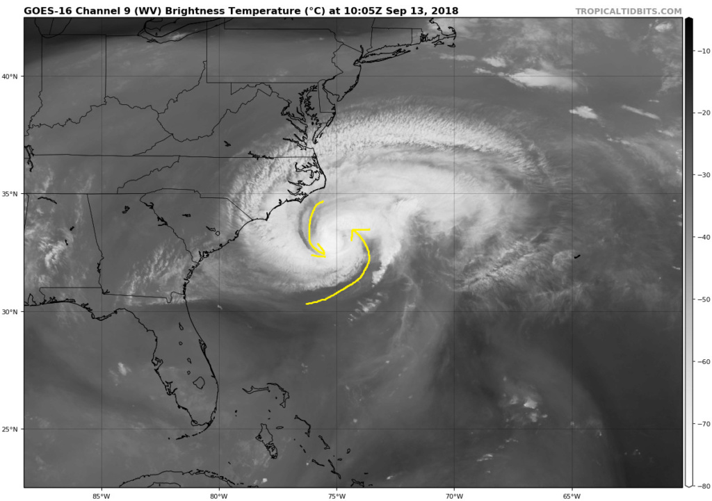
In case you didn't get to see Levi Cowin's video I posted last night here is the main reason why. Dry ai from the south has infiltrated into the system disrupting its core. This is why she looks so ragged and no longer has a well defined eyewall.
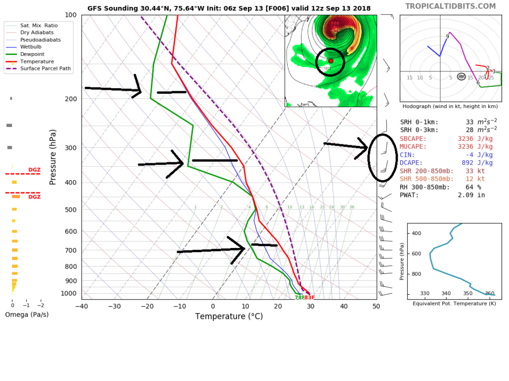
Below are soundings taken from the S and SE sides of Flo. Look top right to see exactly where. Green represents dew point whereas Red line represents temp. Where they separate is where there is dry air. As you can see that at approx. 300mb level there is dry air infiltration. A little further south there is dry air at multiple levels. While there has been minor southerly shear I believe the dry air has been the biggest hinderance over the last 12-24hrs.

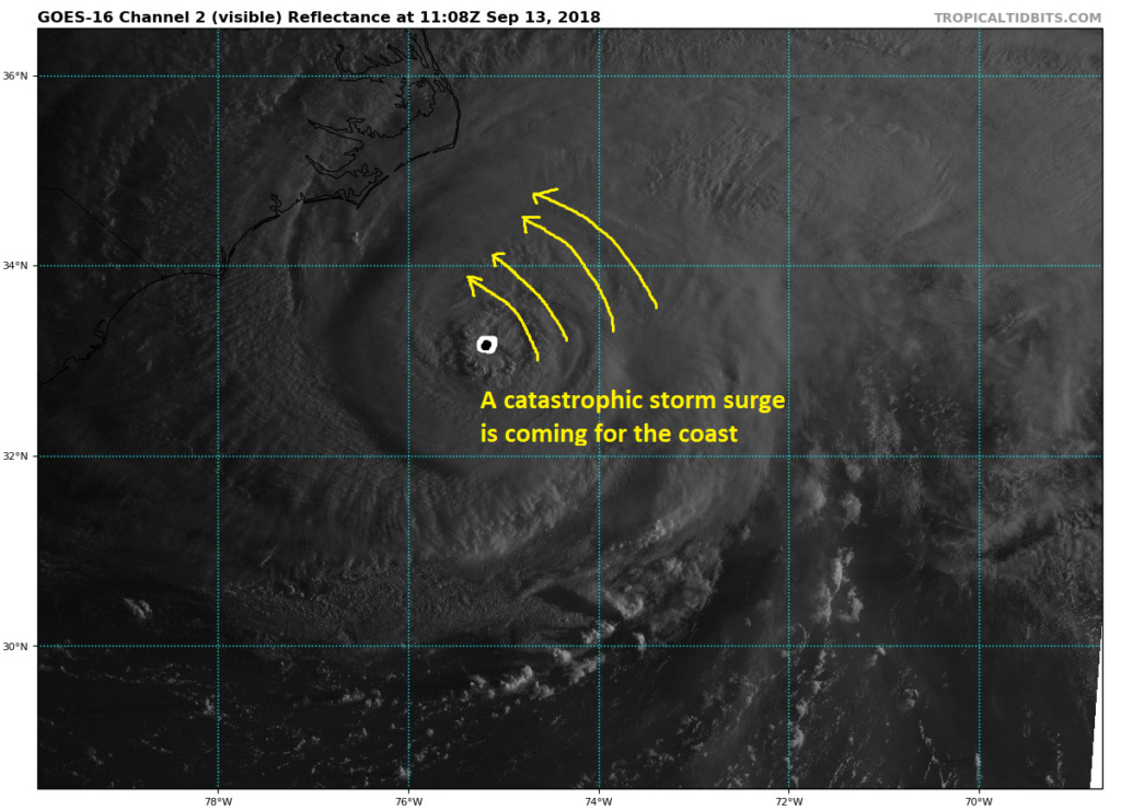
But make no mistake the winds really aren't the biggest concern here; although, they will still cause wide spread severe damage at Cat 2 strength regardless. While there is no doubt "it could be worse", the prolonged major hurricane status and extremely expansive hurricane and trop storm force wind field has been building the storm surge for days, esp in the NE quad. The kinetic energy built up on that N/NE quadrant has been set in motion and a weakening from Cat 4/3/2 status will do very little to weaken the forward momentum of the storm surge. A catastrophic storm surge is still on its way along with feet of flooding rains for a fairly large populated area.
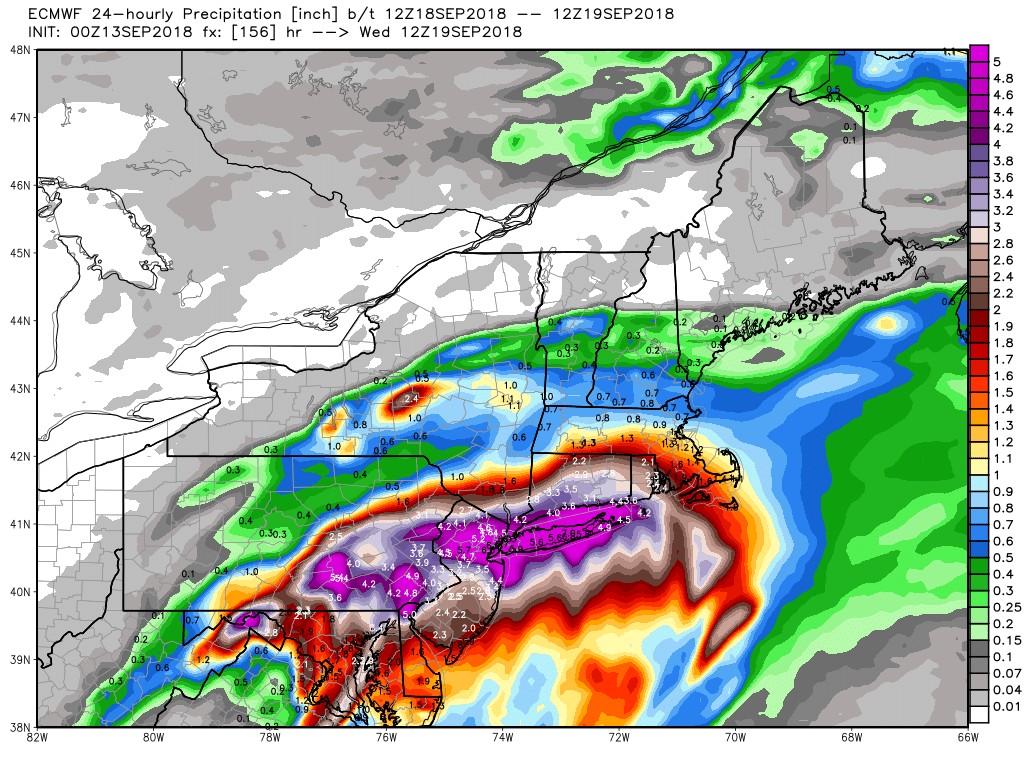
Jman. Yes Euro and other models are showing the potential for impacts from the system some time next week. For now we monitor for the 3day forecast and beyond has been ever shifting soooo. F=Just for kicks this was the euro 24hr precip map for next week

In case you didn't get to see Levi Cowin's video I posted last night here is the main reason why. Dry ai from the south has infiltrated into the system disrupting its core. This is why she looks so ragged and no longer has a well defined eyewall.

Below are soundings taken from the S and SE sides of Flo. Look top right to see exactly where. Green represents dew point whereas Red line represents temp. Where they separate is where there is dry air. As you can see that at approx. 300mb level there is dry air infiltration. A little further south there is dry air at multiple levels. While there has been minor southerly shear I believe the dry air has been the biggest hinderance over the last 12-24hrs.


But make no mistake the winds really aren't the biggest concern here; although, they will still cause wide spread severe damage at Cat 2 strength regardless. While there is no doubt "it could be worse", the prolonged major hurricane status and extremely expansive hurricane and trop storm force wind field has been building the storm surge for days, esp in the NE quad. The kinetic energy built up on that N/NE quadrant has been set in motion and a weakening from Cat 4/3/2 status will do very little to weaken the forward momentum of the storm surge. A catastrophic storm surge is still on its way along with feet of flooding rains for a fairly large populated area.

Jman. Yes Euro and other models are showing the potential for impacts from the system some time next week. For now we monitor for the 3day forecast and beyond has been ever shifting soooo. F=Just for kicks this was the euro 24hr precip map for next week

Last edited by sroc4 on Thu Sep 13, 2018 7:39 am; edited 1 time in total
_________________
"In weather and in life, there's no winning and losing; there's only winning and learning."
WINTER 2012/2013 TOTALS 43.65"WINTER 2017/2018 TOTALS 62.85" WINTER 2022/2023 TOTALS 4.9"
WINTER 2013/2014 TOTALS 64.85"WINTER 2018/2019 TOTALS 14.25" WINTER 2023/2024 TOTALS 13.1"
WINTER 2014/2015 TOTALS 71.20"WINTER 2019/2020 TOTALS 6.35"
WINTER 2015/2016 TOTALS 35.00"WINTER 2020/2021 TOTALS 37.75"
WINTER 2016/2017 TOTALS 42.25"WINTER 2021/2022 TOTALS 31.65"

sroc4- Admin

- Posts : 8354
Reputation : 302
Join date : 2013-01-07
Location : Wading River, LI
 Re: MAJOR HURRICANE FLORENCE part 2: Will have historic impacts to the Carolina coastline and areas inland
weatherwatchermom wrote:mwilli5783 wrote:storm is wimping out,dry air got in from the south side of the storm disrupting the eye wall also looks like it shifted to a north-northwest now
I know the winds are diminishing..but I was watching last night and they were saying that Florence already set the stage for the surge that is coming..some of the waves out in the Atlantic reached 80 feet..that force of water is still coming at them. We lived thru Sandy, look at the destruction that caused and we did not have that winds that this storm is going to produce. Where I lived there was a 15 foot surge. I hope they are wrong and this turns out to be a dud...but they keep talking about how Morehead City is going to take a hard hit...and I have interest there..so here is to them being wrong!!
Exactly weather mom!!
_________________
"In weather and in life, there's no winning and losing; there's only winning and learning."
WINTER 2012/2013 TOTALS 43.65"WINTER 2017/2018 TOTALS 62.85" WINTER 2022/2023 TOTALS 4.9"
WINTER 2013/2014 TOTALS 64.85"WINTER 2018/2019 TOTALS 14.25" WINTER 2023/2024 TOTALS 13.1"
WINTER 2014/2015 TOTALS 71.20"WINTER 2019/2020 TOTALS 6.35"
WINTER 2015/2016 TOTALS 35.00"WINTER 2020/2021 TOTALS 37.75"
WINTER 2016/2017 TOTALS 42.25"WINTER 2021/2022 TOTALS 31.65"

sroc4- Admin

- Posts : 8354
Reputation : 302
Join date : 2013-01-07
Location : Wading River, LI
 Re: MAJOR HURRICANE FLORENCE part 2: Will have historic impacts to the Carolina coastline and areas inland
Don't be surprised to see last min strengthening but time wise there isn't much time for that to happen soit will only go so far
_________________
"In weather and in life, there's no winning and losing; there's only winning and learning."
WINTER 2012/2013 TOTALS 43.65"WINTER 2017/2018 TOTALS 62.85" WINTER 2022/2023 TOTALS 4.9"
WINTER 2013/2014 TOTALS 64.85"WINTER 2018/2019 TOTALS 14.25" WINTER 2023/2024 TOTALS 13.1"
WINTER 2014/2015 TOTALS 71.20"WINTER 2019/2020 TOTALS 6.35"
WINTER 2015/2016 TOTALS 35.00"WINTER 2020/2021 TOTALS 37.75"
WINTER 2016/2017 TOTALS 42.25"WINTER 2021/2022 TOTALS 31.65"

sroc4- Admin

- Posts : 8354
Reputation : 302
Join date : 2013-01-07
Location : Wading River, LI
 Re: MAJOR HURRICANE FLORENCE part 2: Will have historic impacts to the Carolina coastline and areas inland
good thing she's weakening but Dayumm on that rain if its true. Is there any wind threat on the well maps just for kicks? I know we won't know anything until like the weekend at least. But the euro has been most consistent.sroc4 wrote:Florence has been down graded to a Cat 2 hurricane with sustained winds of 110mph. Here is the latest NHC forecast track:
In case you didn't get to see Levi Cowin's video I posted last night here is the main reason why. Dry ai from the south has infiltrated into the system disrupting its core. This is why she looks so ragged and no longer has a well defined eyewall.
Below are soundings taken from the S and SE sides of Flo. Look top right to see exactly where. Green represents dew point whereas Red line represents temp. Where they separate is where there is dry air. As you can see that at approx. 300mb level there is dry air infiltration. A little further south there is dry air at multiple levels. While there has been minor southerly shear I believe the dry air has been the biggest hinderance over the last 12-24hrs.
But make no mistake the winds really aren't the biggest concern here; although, they will still cause wide spread severe damage at Cat 2 strength regardless. While there is no doubt "it could be worse", the prolonged major hurricane status and extremely expansive hurricane and trop storm force wind field has been building the storm surge for days, esp in the NE quad. The kinetic energy built up on that N/NE quadrant has been set in motion and a weakening from Cat 4/3/2 status will do very little to weaken the forward momentum of the storm surge. A catastrophic storm surge is still on its way along with feet of flooding rains for a fairly large populated area.
Jman. Yes Euro and other models are showing the potential for impacts from the system some time next week. For now we monitor for the 3day forecast and beyond has been ever shifting soooo. F=Just for kicks this was the euro 24hr precip map for next week

jmanley32- Senior Enthusiast

- Posts : 20535
Reputation : 108
Join date : 2013-12-12
Age : 43
Location : Yonkers, NY
 Re: MAJOR HURRICANE FLORENCE part 2: Will have historic impacts to the Carolina coastline and areas inland
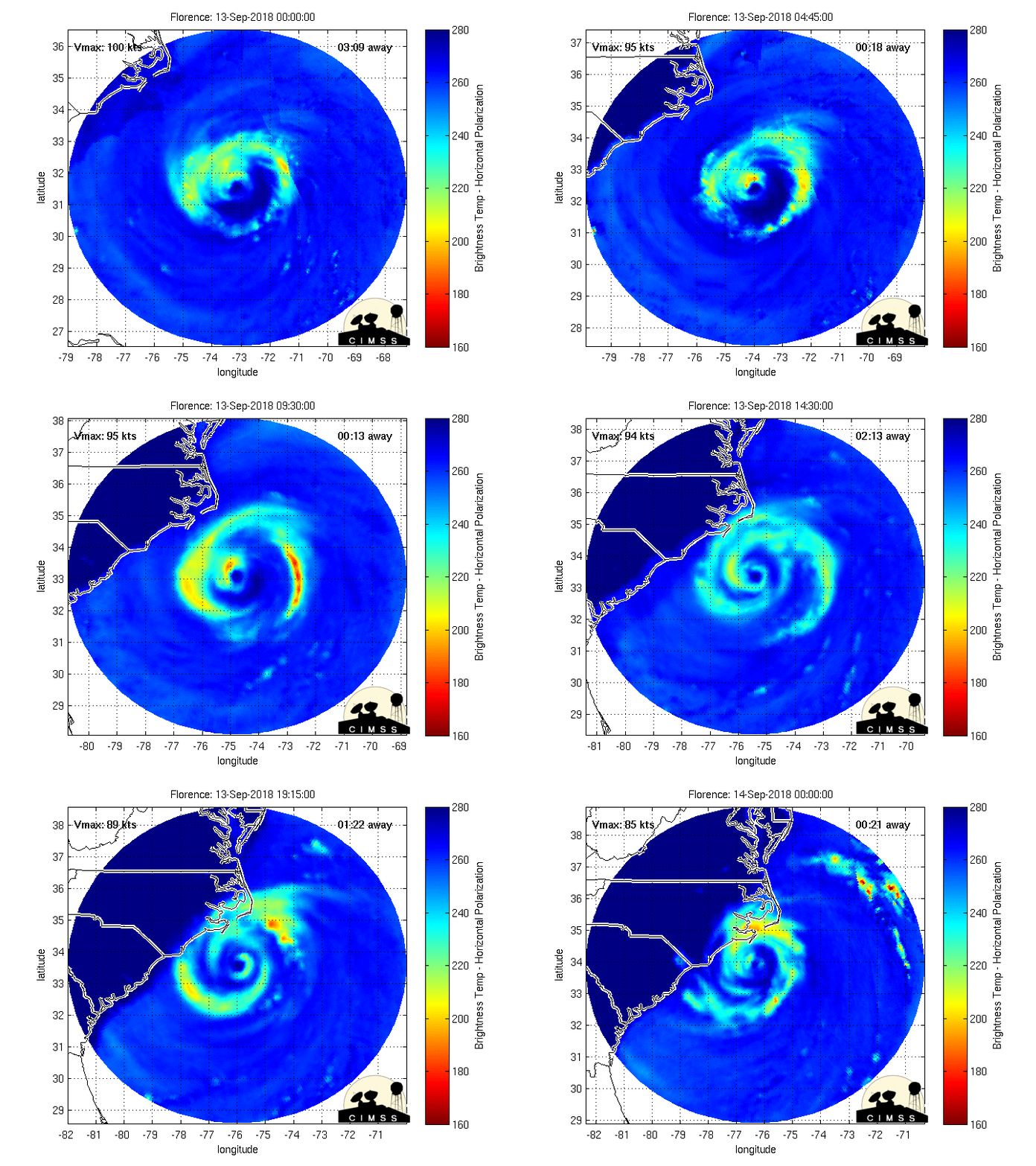
Current recon looks like even further weakening
_________________
"In weather and in life, there's no winning and losing; there's only winning and learning."
WINTER 2012/2013 TOTALS 43.65"WINTER 2017/2018 TOTALS 62.85" WINTER 2022/2023 TOTALS 4.9"
WINTER 2013/2014 TOTALS 64.85"WINTER 2018/2019 TOTALS 14.25" WINTER 2023/2024 TOTALS 13.1"
WINTER 2014/2015 TOTALS 71.20"WINTER 2019/2020 TOTALS 6.35"
WINTER 2015/2016 TOTALS 35.00"WINTER 2020/2021 TOTALS 37.75"
WINTER 2016/2017 TOTALS 42.25"WINTER 2021/2022 TOTALS 31.65"

sroc4- Admin

- Posts : 8354
Reputation : 302
Join date : 2013-01-07
Location : Wading River, LI
 Re: MAJOR HURRICANE FLORENCE part 2: Will have historic impacts to the Carolina coastline and areas inland
I know the flooding will be really bad but the fact that ALL the cable news stations with red colors and flashing lights predicting doomsday with 150 mph winds blah blah blah and now we are down to cat 2 and weakening......people are going to tune the meteorologists out even more and ignore future warnings
This storm prediction and forecast has been embarrassingly bad. It’s 2018. I know hurricanes and weather in general is hard to predict but man!!!!!
This storm prediction and forecast has been embarrassingly bad. It’s 2018. I know hurricanes and weather in general is hard to predict but man!!!!!
Guest- Guest
 Re: MAJOR HURRICANE FLORENCE part 2: Will have historic impacts to the Carolina coastline and areas inland
Hurricane Ike was a cat 2 and look what his storm surge did to coastal areas.

It's likely Florence would will do more damage due to her path and speed

It's likely Florence would will do more damage due to her path and speed
_________________
_______________________________________________________________________________________________________
CLICK HERE to view NJ Strong Snowstorm Classifications
 Re: MAJOR HURRICANE FLORENCE part 2: Will have historic impacts to the Carolina coastline and areas inland
Frank_Wx wrote:Hurricane Ike was a cat 2 and look what his storm surge did to coastal areas.
It's likely Florence would will do more damage due to her path and speed
Hopefully not Frank but you may be right. However no one can deny that the weakening after all week of media hype about the “catastrophic doomsday” is going to have an effect. People who aren’t obsessed with the weather like we are see the wind speed(wrongfully so) and they say oh look at all this panic and hype. We’ve seen and been through 100 mph winds blah blah blah. They then tune meteorologists out. It’s inevitable
Guest- Guest
 Re: MAJOR HURRICANE FLORENCE part 2: Will have historic impacts to the Carolina coastline and areas inland
https://www.wnct.com/weather/webcams/live-eye-9-from-island-traders-beaufort

weatherwatchermom- Senior Enthusiast

- Posts : 3793
Reputation : 78
Join date : 2014-11-25
Location : Hazlet Township, NJ
 Re: MAJOR HURRICANE FLORENCE part 2: Will have historic impacts to the Carolina coastline and areas inland
But what's your definition of catastrophic? Is the above image not considered a catastrophe for so many people? What about the widespread 1-2 FEET (locally 3 feet for some) of rain models continue to show because Florence is caught under a block and has nowhere to go?

It's not just about the wind - which will still be bad. The storm surge and flooding rain is catastrophic enough.
The media hype is absolutely warranted for this storm.

It's not just about the wind - which will still be bad. The storm surge and flooding rain is catastrophic enough.
The media hype is absolutely warranted for this storm.
_________________
_______________________________________________________________________________________________________
CLICK HERE to view NJ Strong Snowstorm Classifications
 Re: MAJOR HURRICANE FLORENCE part 2: Will have historic impacts to the Carolina coastline and areas inland
You’re not getting my point. I know it’s going to be catastrophic flooding between surge and rain. However The majority of the public sees the wind forecast and Category dropping and says its the boy that cried wolf again.
Guest- Guest
 Re: MAJOR HURRICANE FLORENCE part 2: Will have historic impacts to the Carolina coastline and areas inland
Frank_Wx wrote:But what's your definition of catastrophic? Is the above image not considered a catastrophe for so many people? What about the widespread 1-2 FEET (locally 3 feet for some) of rain models continue to show because Florence is caught under a block and has nowhere to go?
It's not just about the wind - which will still be bad. The storm surge and flooding rain is catastrophic enough.
The media hype is absolutely warranted for this storm.
I agree Frank, people are hung up on the category level, when water is always the danger, whether storm surge or rainfall. We have seen what as little as 4-5" of rain can do, what they are in for is just unimaginable. The damage to infrastructure is also a big problem. The storm is not going to just pass and go away, it will be sitting there and first responders and power companies won't be able to get to work for a while... such a dangerous situation.
_________________
Janet
Snowfall winter of 2023-2024 17.5"
Snowfall winter of 2022-2023 6.0"
Snowfall winter of 2021-2022 17.6" 1" sleet 2/25/22
Snowfall winter of 2020-2021 51.1"
Snowfall winter of 2019-2020 8.5"
Snowfall winter of 2018-2019 25.1"
Snowfall winter of 2017-2018 51.9"
Snowfall winter of 2016-2017 45.6"
Snowfall winter of 2015-2016 29.5"
Snowfall winter of 2014-2015 50.55"
Snowfall winter of 2013-2014 66.5"
Dunnzoo- Senior Enthusiast - Mod

- Posts : 4904
Reputation : 68
Join date : 2013-01-11
Age : 62
Location : Westwood, NJ
 Re: MAJOR HURRICANE FLORENCE part 2: Will have historic impacts to the Carolina coastline and areas inland
syosnow94 wrote:You’re not getting my point. I know it’s going to be catastrophic flooding between surge and rain. However The majority of the public sees the wind forecast and Category dropping and says its the boy that cried wolf again.
People are stupid, go figure. They won't be saying "the boy who cried wolf" after this plays out.

hyde345- Pro Enthusiast

- Posts : 1082
Reputation : 48
Join date : 2013-01-08
Location : Hyde Park, NY
 Re: MAJOR HURRICANE FLORENCE part 2: Will have historic impacts to the Carolina coastline and areas inland
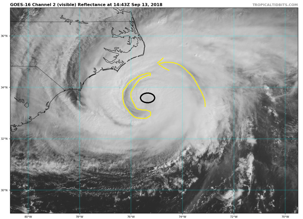
You can see even more dry air being ingested in towards the center of circulation. Make no mistake however, the diaemter of Hurricane force winds is very wide.
https://www.tropicaltidbits.com/sat/satlooper.php?region=06L&product=vis
https://www.tropicaltidbits.com/sat/satlooper.php?region=06L&product=ir

https://www.tropicaltidbits.com/sat/satlooper.php?region=06L&product=vis
https://www.tropicaltidbits.com/sat/satlooper.php?region=06L&product=ir


_________________
"In weather and in life, there's no winning and losing; there's only winning and learning."
WINTER 2012/2013 TOTALS 43.65"WINTER 2017/2018 TOTALS 62.85" WINTER 2022/2023 TOTALS 4.9"
WINTER 2013/2014 TOTALS 64.85"WINTER 2018/2019 TOTALS 14.25" WINTER 2023/2024 TOTALS 13.1"
WINTER 2014/2015 TOTALS 71.20"WINTER 2019/2020 TOTALS 6.35"
WINTER 2015/2016 TOTALS 35.00"WINTER 2020/2021 TOTALS 37.75"
WINTER 2016/2017 TOTALS 42.25"WINTER 2021/2022 TOTALS 31.65"

sroc4- Admin

- Posts : 8354
Reputation : 302
Join date : 2013-01-07
Location : Wading River, LI
 Re: MAJOR HURRICANE FLORENCE part 2: Will have historic impacts to the Carolina coastline and areas inland
Gfs has it going up Ohio River Valley to the great lakes, sparing us a lot of rain...
_________________
Janet
Snowfall winter of 2023-2024 17.5"
Snowfall winter of 2022-2023 6.0"
Snowfall winter of 2021-2022 17.6" 1" sleet 2/25/22
Snowfall winter of 2020-2021 51.1"
Snowfall winter of 2019-2020 8.5"
Snowfall winter of 2018-2019 25.1"
Snowfall winter of 2017-2018 51.9"
Snowfall winter of 2016-2017 45.6"
Snowfall winter of 2015-2016 29.5"
Snowfall winter of 2014-2015 50.55"
Snowfall winter of 2013-2014 66.5"

Dunnzoo- Senior Enthusiast - Mod

- Posts : 4904
Reputation : 68
Join date : 2013-01-11
Age : 62
Location : Westwood, NJ

Joe Snow- Pro Enthusiast

- Posts : 924
Reputation : 7
Join date : 2014-02-12
Age : 62
Location : Sanford Florida, Fmrly Kings Park, NY
 Re: MAJOR HURRICANE FLORENCE part 2: Will have historic impacts to the Carolina coastline and areas inland
Tornado warning Central Hyde County NC

bobjohnsonforthehall- Posts : 311
Reputation : 19
Join date : 2016-10-02
Location : Flemington NJ
 Re: MAJOR HURRICANE FLORENCE part 2: Will have historic impacts to the Carolina coastline and areas inland
Max winds down to 105. Eesh!
Guest- Guest
 Re: MAJOR HURRICANE FLORENCE part 2: Will have historic impacts to the Carolina coastline and areas inland
syosnow94 wrote:You’re not getting my point. I know it’s going to be catastrophic flooding between surge and rain. However The majority of the public sees the wind forecast and Category dropping and says its the boy that cried wolf again.
But your original point was there is too much media hype.
When this is all said and done, the residents down there will actually trust the media more because if it was not for their "hype" they may not have evacuated.
_________________
_______________________________________________________________________________________________________
CLICK HERE to view NJ Strong Snowstorm Classifications
 Re: MAJOR HURRICANE FLORENCE part 2: Will have historic impacts to the Carolina coastline and areas inland
_________________
_______________________________________________________________________________________________________
CLICK HERE to view NJ Strong Snowstorm Classifications
 Re: MAJOR HURRICANE FLORENCE part 2: Will have historic impacts to the Carolina coastline and areas inland
Another factor to consider is that most of South and North Carolina are in the top five wettest years at the moment addFlorence to the mix and for most of the area this will become the wettest year on record and with tropical storm-force winds for a large section down there they'll be lots of trees and power lines down they may be without power for weeks.

algae888- Advanced Forecaster

- Posts : 5311
Reputation : 46
Join date : 2013-02-05
Age : 62
Location : mt. vernon, new york
 Re: MAJOR HURRICANE FLORENCE part 2: Will have historic impacts to the Carolina coastline and areas inland
Frank_Wx wrote:syosnow94 wrote:You’re not getting my point. I know it’s going to be catastrophic flooding between surge and rain. However The majority of the public sees the wind forecast and Category dropping and says its the boy that cried wolf again.
But your original point was there is too much media hype.
When this is all said and done, the residents down there will actually trust the media more because if it was not for their "hype" they may not have evacuated.
Ok. We shall see
Guest- Guest
 Re: MAJOR HURRICANE FLORENCE part 2: Will have historic impacts to the Carolina coastline and areas inland

_________________
"In weather and in life, there's no winning and losing; there's only winning and learning."
WINTER 2012/2013 TOTALS 43.65"WINTER 2017/2018 TOTALS 62.85" WINTER 2022/2023 TOTALS 4.9"
WINTER 2013/2014 TOTALS 64.85"WINTER 2018/2019 TOTALS 14.25" WINTER 2023/2024 TOTALS 13.1"
WINTER 2014/2015 TOTALS 71.20"WINTER 2019/2020 TOTALS 6.35"
WINTER 2015/2016 TOTALS 35.00"WINTER 2020/2021 TOTALS 37.75"
WINTER 2016/2017 TOTALS 42.25"WINTER 2021/2022 TOTALS 31.65"

sroc4- Admin

- Posts : 8354
Reputation : 302
Join date : 2013-01-07
Location : Wading River, LI
Page 3 of 7 •  1, 2, 3, 4, 5, 6, 7
Permissions in this forum:
You cannot reply to topics in this forum|
|
|

 Home
Home