October 2018 Observations & Discussions
+22
SoulSingMG
CPcantmeasuresnow
Snow88
aiannone
skinsfan1177
hyde345
algae888
rb924119
SENJsnowman
docstox12
amugs
larryrock72
sroc4
Fededle22
Radz
Dunnzoo
weatherwatchermom
jmanley32
dkodgis
frank 638
Grselig
Frank_Wx
26 posters
Page 6 of 11
Page 6 of 11 •  1, 2, 3 ... 5, 6, 7 ... 9, 10, 11
 Re: October 2018 Observations & Discussions

Tight Gradient

Wow Frank putting us in STORM MODE this far out is.............
amugs- Advanced Forecaster - Mod

- Posts : 15095
Join date : 2013-01-07
 Re: October 2018 Observations & Discussions
Any wintry threat from this system is gone, in my humble opinion. When you look at the Northern Hemispheric pattern and setup, an inland track, or at the very eastern edge of the most likely spread, would be a coastal hugger. The rapid transition from a -NAO toward a positive mode (1), the lack of a true -AO (2) and 50/50 low argue (3) for the disjointedness we are currently seeing in H5 vorticity maxima. However, they also argue against and work to partially offset the positive influences of the brief PNA (4)/EPO (5) ridge spike coupled with a -WPO (6), in that our source of colder air and northern stream energy will be mitigated. Additionally, the expected further southeastward displacement of the developing/deepening Eastern U.S. trough which would allow the storm track to trend further east (in response to 4-6 above) will also be offset and likely end up yielding to the strengthening ridging developing out ahead of it (in response to 1-3 above), bolstered further by the MJO progression, recent SOI positive state, the previous Niño 1.2 temperature spike, and still anomalously warm western Atlantic. Lastly, the addition of tropical remnants does not help our cause, as that will likely assist a bit in further geopotential height rises via diabatic heat release. While we will still see a storm, it will be a fast moving and likely weak system with a lack of any substantial and sustainable cold air for our region, as we will be warm-sectored. though unsettled conditions will persist for a few days as the multiple spokes of energy rotate through the broad-based, yet lifting trough.
rb924119- Meteorologist

- Posts : 6928
Join date : 2013-02-06
 Re: October 2018 Observations & Discussions
rb924119 wrote:Any wintry threat from this system is gone, in my humble opinion. When you look at the Northern Hemispheric pattern and setup, an inland track, or at the very eastern edge of the most likely spread, would be a coastal hugger. The rapid transition from a -NAO toward a positive mode (1), the lack of a true -AO (2) and 50/50 low argue (3) for the disjointedness we are currently seeing in H5 vorticity maxima. However, they also argue against and work to partially offset the positive influences of the brief PNA (4)/EPO (5) ridge spike coupled with a -WPO (6), in that our source of colder air and northern stream energy will be mitigated. Additionally, the expected further southeastward displacement of the developing/deepening Eastern U.S. trough which would allow the storm track to trend further east (in response to 4-6 above) will also be offset and likely end up yielding to the strengthening ridging developing out ahead of it (in response to 1-3 above), bolstered further by the MJO progression, recent SOI positive state, the previous Niño 1.2 temperature spike, and still anomalously warm western Atlantic. Lastly, the addition of tropical remnants does not help our cause, as that will likely assist a bit in further geopotential height rises via diabatic heat release. While we will still see a storm, it will be a fast moving and likely weak system with a lack of any substantial and sustainable cold air for our region, as we will be warm-sectored. though unsettled conditions will persist for a few days as the multiple spokes of energy rotate through the broad-based, yet lifting trough.
Good info. I love winter threats, but when leaves are still on the trees (a few Halloweens ago), we get serious power outages and lots of trees down.

Grselig- Senior Enthusiast

- Posts : 1408
Reputation : 140
Join date : 2013-03-04
Age : 54
Location : Wayne NJ
 Re: October 2018 Observations & Discussions
Well, for a 43% chance of precipitation it is dark, ominous, and heavily raining here at 3 o'cock

dkodgis- Senior Enthusiast

- Posts : 2560
Reputation : 98
Join date : 2013-12-29
 Re: October 2018 Observations & Discussions
dkodgis wrote:Well, for a 43% chance of precipitation it is dark, ominous, and heavily raining here at 3 o'cock
Wow. Clear and sunny in Wayne NJ

Grselig- Senior Enthusiast

- Posts : 1408
Reputation : 140
Join date : 2013-03-04
Age : 54
Location : Wayne NJ
 Re: October 2018 Observations & Discussions
power impacts will be mini.sized without snow Def but remember how wet it still is and trees won't need a lot to uproot. Branches breaking wouldn't be the biggest issue unless we had the snow.Grselig wrote:rb924119 wrote:Any wintry threat from this system is gone, in my humble opinion. When you look at the Northern Hemispheric pattern and setup, an inland track, or at the very eastern edge of the most likely spread, would be a coastal hugger. The rapid transition from a -NAO toward a positive mode (1), the lack of a true -AO (2) and 50/50 low argue (3) for the disjointedness we are currently seeing in H5 vorticity maxima. However, they also argue against and work to partially offset the positive influences of the brief PNA (4)/EPO (5) ridge spike coupled with a -WPO (6), in that our source of colder air and northern stream energy will be mitigated. Additionally, the expected further southeastward displacement of the developing/deepening Eastern U.S. trough which would allow the storm track to trend further east (in response to 4-6 above) will also be offset and likely end up yielding to the strengthening ridging developing out ahead of it (in response to 1-3 above), bolstered further by the MJO progression, recent SOI positive state, the previous Niño 1.2 temperature spike, and still anomalously warm western Atlantic. Lastly, the addition of tropical remnants does not help our cause, as that will likely assist a bit in further geopotential height rises via diabatic heat release. While we will still see a storm, it will be a fast moving and likely weak system with a lack of any substantial and sustainable cold air for our region, as we will be warm-sectored. though unsettled conditions will persist for a few days as the multiple spokes of energy rotate through the broad-based, yet lifting trough.
Good info. I love winter threats, but when leaves are still on the trees (a few Halloweens ago), we get serious power outages and lots of trees down.

jmanley32- Senior Enthusiast

- Posts : 20535
Reputation : 108
Join date : 2013-12-12
Age : 43
Location : Yonkers, NY
 Re: October 2018 Observations & Discussions
There will be a coastal gale with some tidal flooding, but otherwise just rain.
rb924119- Meteorologist

- Posts : 6928
Reputation : 194
Join date : 2013-02-06
Age : 32
Location : Greentown, Pa
 Re: October 2018 Observations & Discussions
rb924119 wrote:There will be a coastal gale with some tidal flooding, but otherwise just rain.
which means a normal weekend storm this year!!! we had white caps in our creek on Sunday..it was wild

weatherwatchermom- Senior Enthusiast

- Posts : 3793
Reputation : 78
Join date : 2014-11-25
Location : Hazlet Township, NJ

SoulSingMG- Senior Enthusiast

- Posts : 2853
Reputation : 74
Join date : 2013-12-11
Location : Long Island City, NY
 Re: October 2018 Observations & Discussions
so not really a nor Easter so u disagree with frank going storm mode? I mean we have had plenty of plain rain events but frank hasn't hoisted storm mode.rb924119 wrote:There will be a coastal gale with some tidal flooding, but otherwise just rain.

jmanley32- Senior Enthusiast

- Posts : 20535
Reputation : 108
Join date : 2013-12-12
Age : 43
Location : Yonkers, NY
 Re: October 2018 Observations & Discussions
A nuisance weekend rain

skinsfan1177- Senior Enthusiast

- Posts : 4485
Reputation : 35
Join date : 2013-01-07
Age : 46
Location : Point Pleasant Boro
 Re: October 2018 Observations & Discussions
Yawn okay good to know. Frank why the storm mode seems there's consensus this is go be nothing by many members.

jmanley32- Senior Enthusiast

- Posts : 20535
Reputation : 108
Join date : 2013-12-12
Age : 43
Location : Yonkers, NY
 Re: October 2018 Observations & Discussions
I guess there were some rogue storms sparsely scattered today one prompted a tornado warning on the ri mass border.

jmanley32- Senior Enthusiast

- Posts : 20535
Reputation : 108
Join date : 2013-12-12
Age : 43
Location : Yonkers, NY
 Re: October 2018 Observations & Discussions
jmanley32 wrote:so not really a nor Easter so u disagree with frank going storm mode? I mean we have had plenty of plain rain events but frank hasn't hoisted storm mode.rb924119 wrote:There will be a coastal gale with some tidal flooding, but otherwise just rain.
No, it’ll be a Nor’easter, and that’s his call haha this peanut gallery doesn’t comment on such things, but given the expected precipitation amounts, the wind, and the type of system/time of year, I don’t see why he shouldn’t have. I mean, if we were dealing with the same system with colder air we’d certainly be in storm mode, so while I don’t really pay attention to that stuff, I appreciate the consistency haha
rb924119- Meteorologist

- Posts : 6928
Reputation : 194
Join date : 2013-02-06
Age : 32
Location : Greentown, Pa
 Re: October 2018 Observations & Discussions
I think all rb is saying is this is not a winter storm. I don’t think there is “consensus” that this is “nothing”. It is heavy rain and gusty winds with coastal flooding. For those who only get fired up by snow, that may be nothing, but in terms of weather, nor’easters are one of our most dynamic weather events in this part of the country - snow or not.

billg315- Advanced Forecaster - Mod

- Posts : 4483
Reputation : 185
Join date : 2015-01-24
Age : 50
Location : Flemington, NJ
 Re: October 2018 Observations & Discussions
sorry I was not taking Frank's storm mode lightly...I had tongue in cheek comment on more rain...noreeasters are nothing to sneeze at..I remember the day after we moved into this house we had a really strong one...rb924119 wrote:jmanley32 wrote:so not really a nor Easter so u disagree with frank going storm mode? I mean we have had plenty of plain rain events but frank hasn't hoisted storm mode.rb924119 wrote:There will be a coastal gale with some tidal flooding, but otherwise just rain.
No, it’ll be a Nor’easter, and that’s his call haha this peanut gallery doesn’t comment on such things, but given the expected precipitation amounts, the wind, and the type of system/time of year, I don’t see why he shouldn’t have. I mean, if we were dealing with the same system with colder air we’d certainly be in storm mode, so while I don’t really pay attention to that stuff, I appreciate the consistency haha

weatherwatchermom- Senior Enthusiast

- Posts : 3793
Reputation : 78
Join date : 2014-11-25
Location : Hazlet Township, NJ
 Re: October 2018 Observations & Discussions
Yikes, possible tornados and funnel clouds in Massachusetts today, funny how New England, NYS have been seeing severe weather lately....
_________________
Janet
Snowfall winter of 2023-2024 17.5"
Snowfall winter of 2022-2023 6.0"
Snowfall winter of 2021-2022 17.6" 1" sleet 2/25/22
Snowfall winter of 2020-2021 51.1"
Snowfall winter of 2019-2020 8.5"
Snowfall winter of 2018-2019 25.1"
Snowfall winter of 2017-2018 51.9"
Snowfall winter of 2016-2017 45.6"
Snowfall winter of 2015-2016 29.5"
Snowfall winter of 2014-2015 50.55"
Snowfall winter of 2013-2014 66.5"
Dunnzoo- Senior Enthusiast - Mod

- Posts : 4905
Reputation : 68
Join date : 2013-01-11
Age : 62
Location : Westwood, NJ
 Re: October 2018 Observations & Discussions
billg315 wrote:I think all rb is saying is this is not a winter storm. I don’t think there is “consensus” that this is “nothing”. It is heavy rain and gusty winds with coastal flooding. For those who only get fired up by snow, that may be nothing, but in terms of weather, nor’easters are one of our most dynamic weather events in this part of the country - snow or not.
Just what I need to hear. This should get the fal fishing run started
Guest- Guest
 Re: October 2018 Observations & Discussions
I was fully expecting a pissing and moaning comment seeing syo posted lol, that this is not gonna be snow, jk. I know nothing about fishing how would a noreaster help fall fishing? And man fall is like 2/3 over better get it in quick lolsyosnow94 wrote:billg315 wrote:I think all rb is saying is this is not a winter storm. I don’t think there is “consensus” that this is “nothing”. It is heavy rain and gusty winds with coastal flooding. For those who only get fired up by snow, that may be nothing, but in terms of weather, nor’easters are one of our most dynamic weather events in this part of the country - snow or not.
Just what I need to hear. This should get the fal fishing run started
I see the wind threat is more from the pressure gradient between the LP and high above it not so much the storm itself, It seems to be modeled weaker and weaker each run now not even getting out of the 990s or even low 1000's. Some ensembles still show sub 970 and even lower but the majority are agreed on intensity.

jmanley32- Senior Enthusiast

- Posts : 20535
Reputation : 108
Join date : 2013-12-12
Age : 43
Location : Yonkers, NY

jmanley32- Senior Enthusiast

- Posts : 20535
Reputation : 108
Join date : 2013-12-12
Age : 43
Location : Yonkers, NY

SoulSingMG- Senior Enthusiast

- Posts : 2853
Reputation : 74
Join date : 2013-12-11
Location : Long Island City, NY
 Re: October 2018 Observations & Discussions
Scott the euro and gfs are still showing all the main precip to the east do you still think this is incorrect? And what is causing that on the models. 2 to 3 inches isn't much considering duration. Now if this were snow boy would it b for the records imagine 10 to 20 inches factoring in slush in October.

jmanley32- Senior Enthusiast

- Posts : 20535
Reputation : 108
Join date : 2013-12-12
Age : 43
Location : Yonkers, NY
 Re: October 2018 Observations & Discussions
I will certainly conceded that this no longer excites me for much frozen stuff. In fairness to myself my comments the other day had several different 500mb solns that were more consolidated with some of the 500mb vorticity lending to the possibility of a "self made" colder soln scenario, and I have not been following the evolution along all that closely at all. The self generated cold air scenario just doesn't appear to be happening. There are a few things about this storm. 1) which Ray has already alluded to and that is the source region is too warm; modified Pacific, deep south, and sub tropics. Very hard to over come these source regions this time of year. You need a very potent phased system to generate/draw in enough cold air from the north.
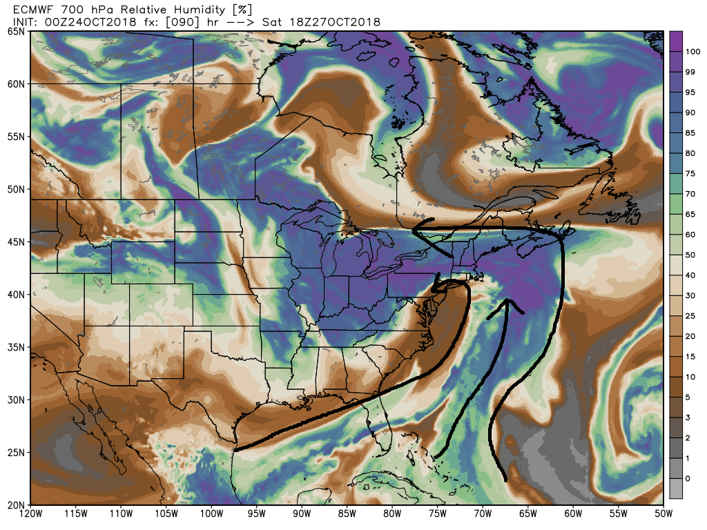
2) it appears 500mb closes off over the Ohio valley and passes N and NW of the region. Our area usually wants to have a 500mb closed low pass more to our south to get into the colder sector.
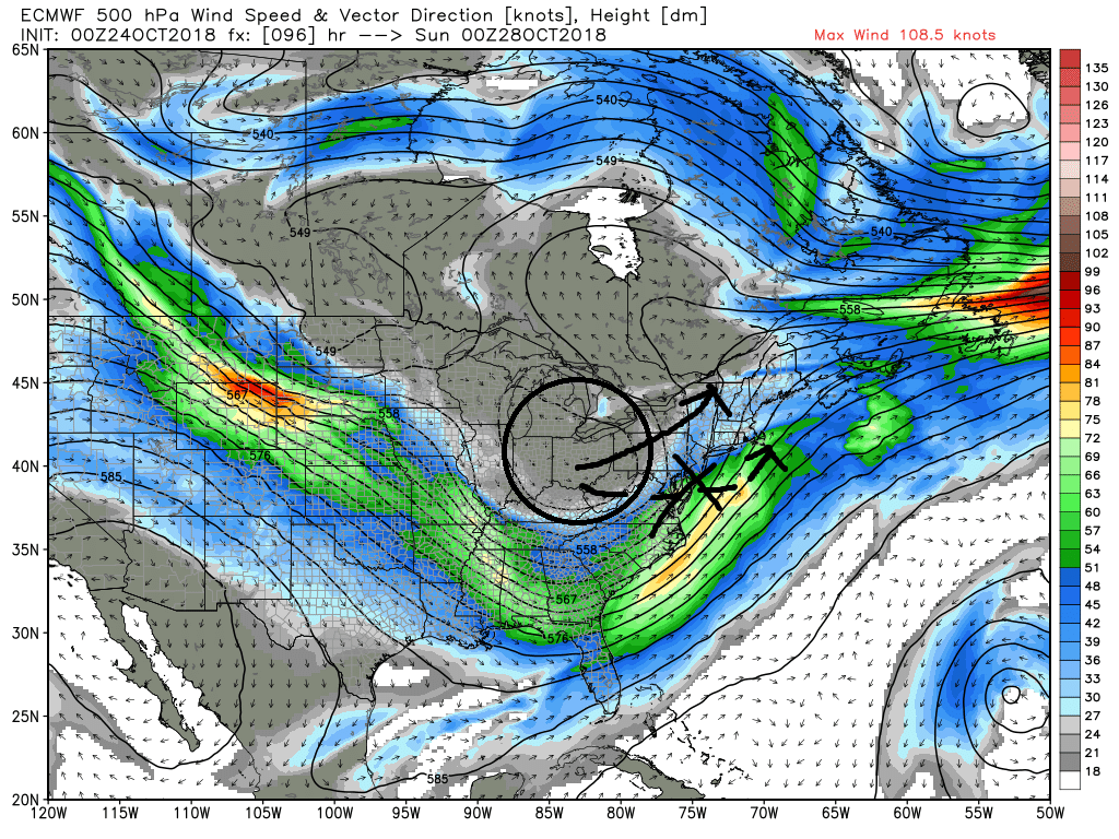
3) Jon to answer your question in part there is a ton of vorticity at 500mb none of which is definitively phased or consolidated associated with the mean 500mb trough. However; looking at the vorticity maps at 850mb there is a ton of strong strung out vorticity there too. My guess is that if these maps are correct on the euro that because the 500mb vorticity isn't a single phased consolidated system that this energy at 850mb is enhancing lift in these areas complimented by a strong LLjet set up along a frontal boundary, so more intense mesoscale vertical lifting rainfall, rather than a tightly wound "classic" Nor' Easter is occurring and why the precip shield looks the way it does on the Euro. Don't get me wrong there is plenty energy aloft such that a strong storm with strong winds and heavy rain will happen, but it isn't the typical "classic" Winter Nor' Easter with a strong phased 500mb system.

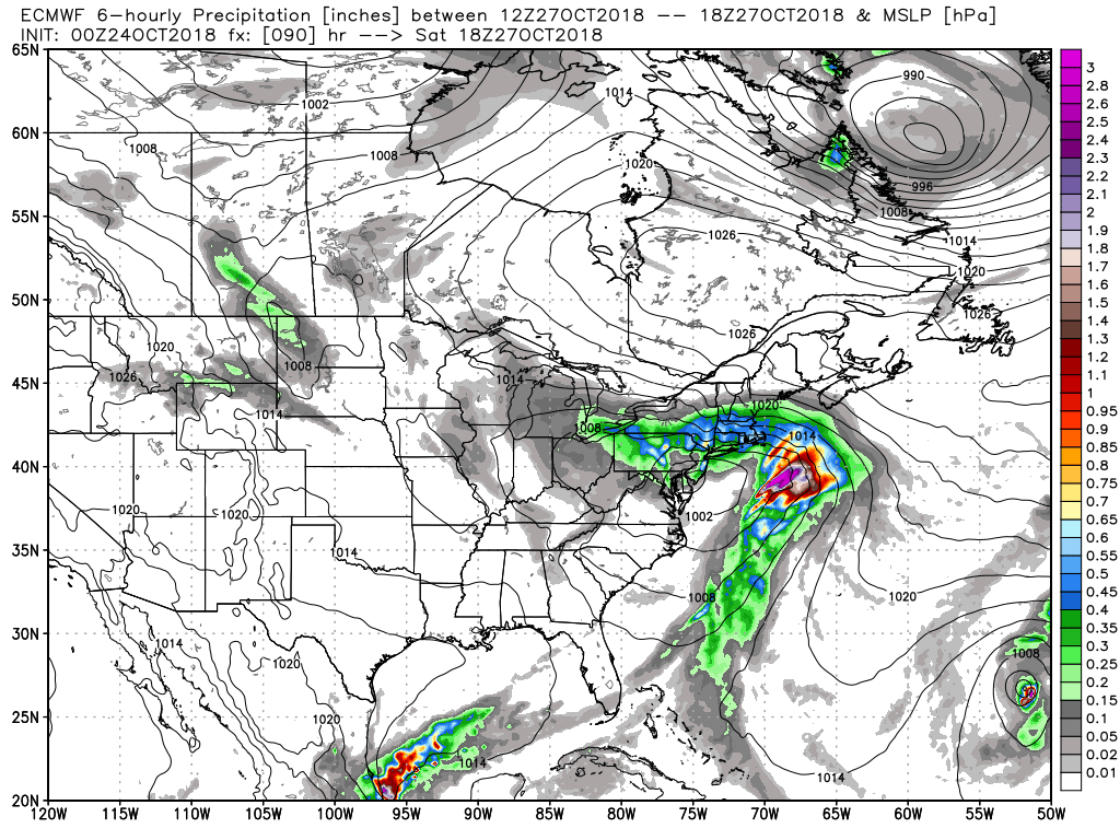

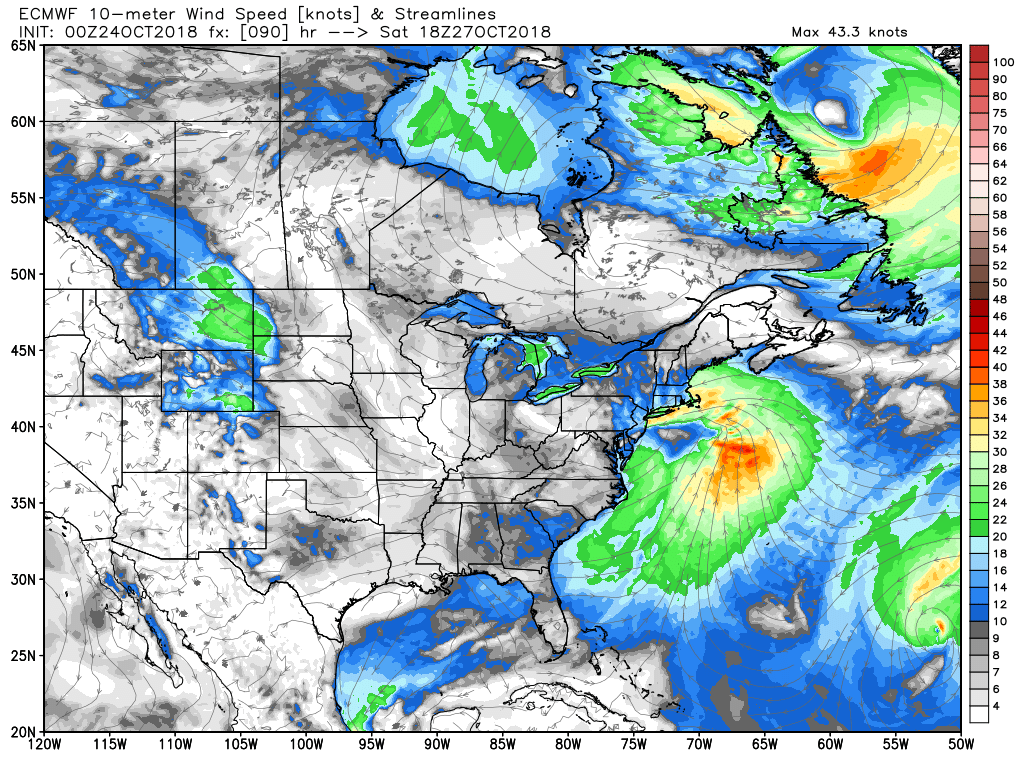

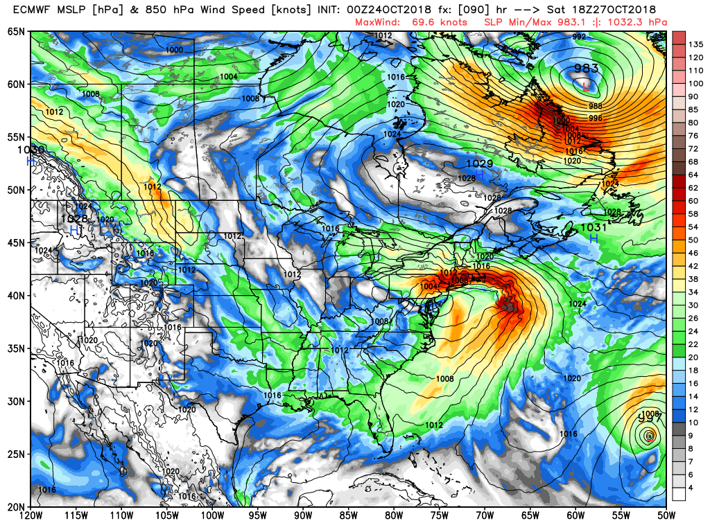

2) it appears 500mb closes off over the Ohio valley and passes N and NW of the region. Our area usually wants to have a 500mb closed low pass more to our south to get into the colder sector.

3) Jon to answer your question in part there is a ton of vorticity at 500mb none of which is definitively phased or consolidated associated with the mean 500mb trough. However; looking at the vorticity maps at 850mb there is a ton of strong strung out vorticity there too. My guess is that if these maps are correct on the euro that because the 500mb vorticity isn't a single phased consolidated system that this energy at 850mb is enhancing lift in these areas complimented by a strong LLjet set up along a frontal boundary, so more intense mesoscale vertical lifting rainfall, rather than a tightly wound "classic" Nor' Easter is occurring and why the precip shield looks the way it does on the Euro. Don't get me wrong there is plenty energy aloft such that a strong storm with strong winds and heavy rain will happen, but it isn't the typical "classic" Winter Nor' Easter with a strong phased 500mb system.


_________________
"In weather and in life, there's no winning and losing; there's only winning and learning."
WINTER 2012/2013 TOTALS 43.65"WINTER 2017/2018 TOTALS 62.85" WINTER 2022/2023 TOTALS 4.9"
WINTER 2013/2014 TOTALS 64.85"WINTER 2018/2019 TOTALS 14.25" WINTER 2023/2024 TOTALS 13.1"
WINTER 2014/2015 TOTALS 71.20"WINTER 2019/2020 TOTALS 6.35"
WINTER 2015/2016 TOTALS 35.00"WINTER 2020/2021 TOTALS 37.75"
WINTER 2016/2017 TOTALS 42.25"WINTER 2021/2022 TOTALS 31.65"

sroc4- Admin

- Posts : 8354
Reputation : 302
Join date : 2013-01-07
Location : Wading River, LI
 Re: October 2018 Observations & Discussions
And after Sat, Sun looks dry but more rain come Monday?

dkodgis- Senior Enthusiast

- Posts : 2560
Reputation : 98
Join date : 2013-12-29
 Re: October 2018 Observations & Discussions
dkodgis wrote:And after Sat, Sun looks dry but more rain come Monday?
There could be wrap around rain Sunday morning. It is likely to be overcast most of the day. Then Monday a clipper-like system, very weak, will pass by bringing us more rain. Less than 1 inch.
_________________
_______________________________________________________________________________________________________
CLICK HERE to view NJ Strong Snowstorm Classifications
 Re: October 2018 Observations & Discussions
I hate all this rain I'm a yard sale picker and its my favorite thing to do on Saturdays when it rains not only do I miss out on the fun but I don't make money. And yes I often actually make more money reselling stuff than I do at my regular job. I just realized this is banter. I'm ill so if you guys wanna move it please do I'm not retype it. Will there be enough instability to have at least some thunderstorms with the nor Easter? 30 to 50mph winds are winds that start to impress me but not overly exciting. I can't explain why wind interests me so muxh. Snow is easier to understand. I will say one thing after seeing crazy storm chasers in Michael and 150 plus mph gusts I never want to be in that that's way to high.

jmanley32- Senior Enthusiast

- Posts : 20535
Reputation : 108
Join date : 2013-12-12
Age : 43
Location : Yonkers, NY
 Re: October 2018 Observations & Discussions
quick question...what is the timing of this storm..we need to travel Sat morning to an event..just curious

weatherwatchermom- Senior Enthusiast

- Posts : 3793
Reputation : 78
Join date : 2014-11-25
Location : Hazlet Township, NJ
Page 6 of 11 •  1, 2, 3 ... 5, 6, 7 ... 9, 10, 11
Page 6 of 11
Permissions in this forum:
You cannot reply to topics in this forum|
|
|

 Home
Home