October Discussion & Observations
+19
Frank_Wx
rb924119
mwilli
GreyBeard
aiannone
algae888
billg315
SoulSingMG
jmanley32
frank 638
Snow88
weatherwatchermom
Math23x7
dkodgis
amugs
docstox12
Dunnzoo
Frankdp23
sroc4
23 posters
Page 2 of 8 •  1, 2, 3, 4, 5, 6, 7, 8
amugs- Advanced Forecaster - Mod

- Posts : 15095
Join date : 2013-01-07
amugs- Advanced Forecaster - Mod

- Posts : 15095
Join date : 2013-01-07
 Re: October Discussion & Observations
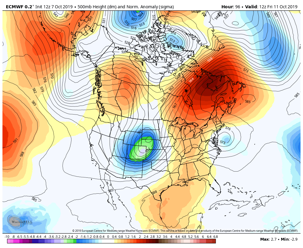
Yep puts wind gusts into the 50s around tristate long island into 60s plus!! Per Euro, the euro is showing this system to have a eye!!

jmanley32- Senior Enthusiast

- Posts : 20535
Reputation : 108
Join date : 2013-12-12
Age : 43
Location : Yonkers, NY
 Re: October Discussion & Observations
Looks like thursday not wednesday and sticks around till Sat!! Worst of it during day Thursday.

jmanley32- Senior Enthusiast

- Posts : 20535
Reputation : 108
Join date : 2013-12-12
Age : 43
Location : Yonkers, NY
 Re: October Discussion & Observations
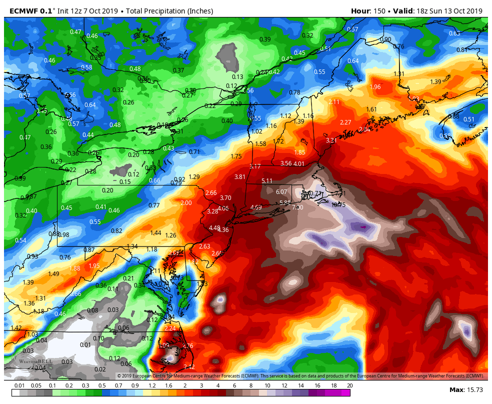
WOW!! Holy smokes Mass and cape 11 inches of rain and near hurricane force winds for LI!! This thing any stronger and further west and its gonna be a mess.
rain totals from system:
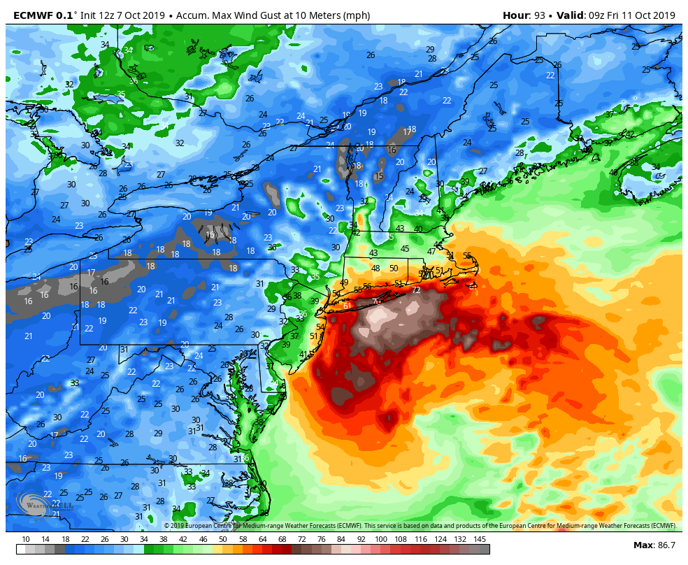
Wind swath: soul we better batten down the hatches even here!! Gust pushing 60mph on thursday. and 30-45 for a very long duration
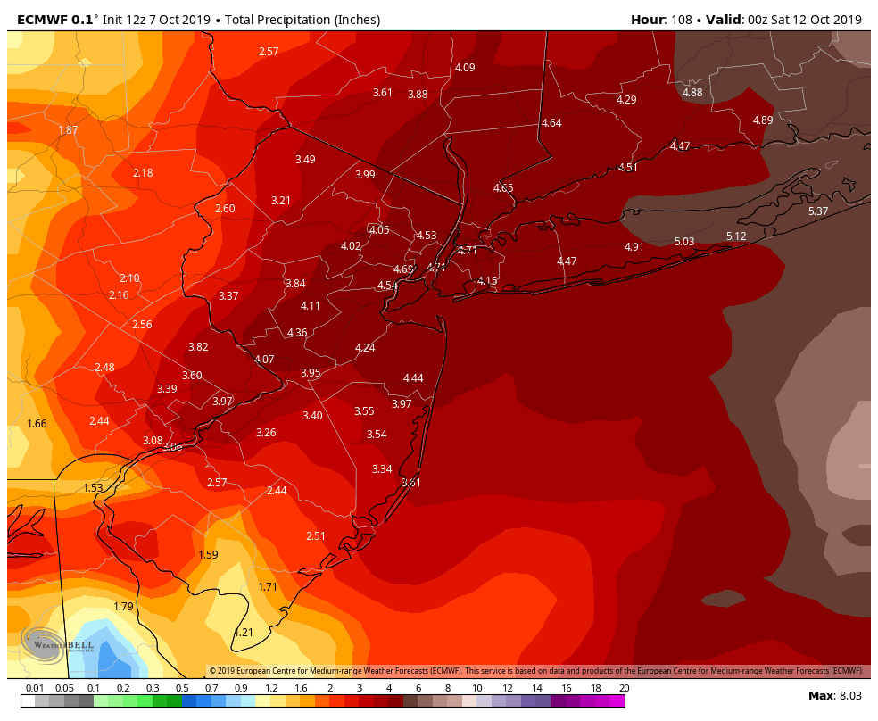
closer look wow, widespread 4-5 inches of rain!! Only .5 or less of that is tonight.
rain totals from system:

Wind swath: soul we better batten down the hatches even here!! Gust pushing 60mph on thursday. and 30-45 for a very long duration

closer look wow, widespread 4-5 inches of rain!! Only .5 or less of that is tonight.


jmanley32- Senior Enthusiast

- Posts : 20535
Reputation : 108
Join date : 2013-12-12
Age : 43
Location : Yonkers, NY
 Re: October Discussion & Observations
Honestly this system looks a lot like sandy in terms of that sudden turn to the NW and west, not saying it would be anywhere near that magnitude of course nothing points to that but it is a retrograde which i believe is the same thing that caused sady to retrograde i may be wrong.

jmanley32- Senior Enthusiast

- Posts : 20535
Reputation : 108
Join date : 2013-12-12
Age : 43
Location : Yonkers, NY
 Re: October Discussion & Observations
_________________
Mugs
AKA:King: Snow Weenie
Self Proclaimed
WINTER 2014-15 : 55.12" +.02 for 6 coatings (avg. 35")
WINTER 2015-16 Total - 29.8" (Avg 35")
WINTER 2016-17 : 39.5" so far

amugs- Advanced Forecaster - Mod

- Posts : 15095
Reputation : 213
Join date : 2013-01-07
Age : 54
Location : Hillsdale,NJ

jmanley32- Senior Enthusiast

- Posts : 20535
Reputation : 108
Join date : 2013-12-12
Age : 43
Location : Yonkers, NY
 Re: October Discussion & Observations
The GFS and NAM both keep the coastal low far enough offshore that the worst effects stay offshore (or maybe parts of LI) except a possible heavy shower band or two passing through Wed-Fri. Then a passing frontal system finally kicks it out by Saturday. Problem is it just sits there spinning for three days so if it does take a slight jog back west that could cause problems especially right on the coastal areas. Still bears watching for the next few days.

billg315- Advanced Forecaster - Mod

- Posts : 4483
Reputation : 185
Join date : 2015-01-24
Age : 50
Location : Flemington, NJ
 Re: October Discussion & Observations
The one feature I like right now with the pattern and has been consistent for the last two-plus months is high pressure over Northern New England and Southeast Canada. This pattern in Winter there would be a lot of over running events 6 + hours of snow ending as drizzle or freezing drizzle which is fine by me. The one thing I despise is high pressure sliding off the Virginia capes as a storm approaches and we get that South to Southwest flow which warms up the low levels and all but eliminates any chances of snow. Without this persistent feature the second half of summer we would have roasted along with the Mid-Atlantic Southeast and Tennessee Valley which many places recorded the most 90° days ever

algae888- Advanced Forecaster

- Posts : 5311
Reputation : 46
Join date : 2013-02-05
Age : 62
Location : mt. vernon, new york

jmanley32- Senior Enthusiast

- Posts : 20535
Reputation : 108
Join date : 2013-12-12
Age : 43
Location : Yonkers, NY
 Re: October Discussion & Observations
NAM shows this system just sitting at the bench mark not wavering much, a push west will mean a world of difference but it appears nam has a lot of rounds of heavy rain and 35 to 50mph gusts wed to thursday.

jmanley32- Senior Enthusiast

- Posts : 20535
Reputation : 108
Join date : 2013-12-12
Age : 43
Location : Yonkers, NY
 Re: October Discussion & Observations
I am looking forward to the first nor'easter of the season. Weather has been boring as of late.
_________________
-Alex Iannone-

aiannone- Senior Enthusiast - Mod

- Posts : 4815
Reputation : 92
Join date : 2013-01-07
Location : Saint James, LI (Northwest Suffolk Co.)
 Re: October Discussion & Observations
We will see, will be interesting watch it form which it is doing so now and its also merging with abnother developing system to its south, kinda a hybrid situation. Then will be a nowcast I guess as to how far west it goes or just sits.aiannone wrote:I am looking forward to the first nor'easter of the season. Weather has been boring as of late.

jmanley32- Senior Enthusiast

- Posts : 20535
Reputation : 108
Join date : 2013-12-12
Age : 43
Location : Yonkers, NY
 Re: October Discussion & Observations
NAM is quite a bit stronger and taking a more turn to the west at hour 31, 996mb previous run 1002mb.
Thursday takes a SW or WSW movement, all the highest winds are to the north and just train from the cape to NJ even inland. Heavy rain bouts too. Thats just going to pile water into LI sound and jersey shore...yikses. rare we have a system make loops and then head SW.
Thursday takes a SW or WSW movement, all the highest winds are to the north and just train from the cape to NJ even inland. Heavy rain bouts too. Thats just going to pile water into LI sound and jersey shore...yikses. rare we have a system make loops and then head SW.

jmanley32- Senior Enthusiast

- Posts : 20535
Reputation : 108
Join date : 2013-12-12
Age : 43
Location : Yonkers, NY
 Re: October Discussion & Observations
It was a high of 58 today. Unfortunately, I got in a full day of grass cutting, blowing leaves, and raking. The sky glared at me today but not even a spritz of rain. I see by this time next week the night time temps start dipping into the mid 30s plus - at least up here. I am a bit surprised the rain did not reach us.

dkodgis- Senior Enthusiast

- Posts : 2560
Reputation : 98
Join date : 2013-12-29
 Re: October Discussion & Observations
so far we ended up 0.56 inches of rain mostly in the morning into mid afternoon part 2 is coming tom afternoon and it looks heavier then today
frank 638- Senior Enthusiast

- Posts : 2843
Reputation : 37
Join date : 2016-01-01
Age : 40
Location : bronx ny
 Re: October Discussion & Observations
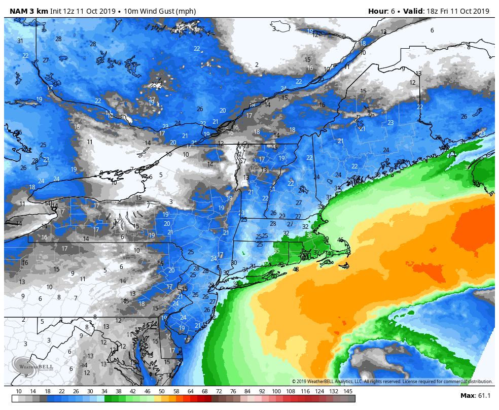
If 3km nam is right very heavy rain tomorrow into friday training in from east in bands and windy with a max gust of 52mph at white plains. We will see what happens.frank 638 wrote:so far we ended up 0.56 inches of rain mostly in the morning into mid afternoon part 2 is coming tom afternoon and it looks heavier then today

jmanley32- Senior Enthusiast

- Posts : 20535
Reputation : 108
Join date : 2013-12-12
Age : 43
Location : Yonkers, NY
 Re: October Discussion & Observations
thankyou for the update i hope not i will take the rain not the wind last thing we need is power outagesjmanley32 wrote:If 3km nam is right very heavy rain tomorrow into friday training in from east in bands and windy with a max gust of 52mph at white plains. We will see what happens.frank 638 wrote:so far we ended up 0.56 inches of rain mostly in the morning into mid afternoon part 2 is coming tom afternoon and it looks heavier then today
frank 638- Senior Enthusiast

- Posts : 2843
Reputation : 37
Join date : 2016-01-01
Age : 40
Location : bronx ny
 Re: October Discussion & Observations
63 degrees partly cloudy.
People were complaining a few weeks ago about the brown Autumn colors.If you get a chance this weekend, take a ride in my neck of the woods.Brilliant oranges, reds and yellows.
People were complaining a few weeks ago about the brown Autumn colors.If you get a chance this weekend, take a ride in my neck of the woods.Brilliant oranges, reds and yellows.

docstox12- Wx Statistician Guru

- Posts : 8530
Reputation : 222
Join date : 2013-01-07
Age : 73
Location : Monroe NY
 Re: October Discussion & Observations
Surprisingly not a drop of rain all day here in Nassau county. Has been mostly sunny but windy with steady 20 mph and gusts to 30. Warmer than expected too with a current temp of 66°. Not much in the way of fall colors yet,as doc said, more brown than any vibrant colors, but we are usually behind you folks to the north by a week or 2. Haven't had to touch a rake yet,which I am ok with that. One of my least favorite yard chores is raking and bagging leaves. When I was a kid, it was permitted to burn them curbside or in your yard but I'm dating myself on that.
GreyBeard- Senior Enthusiast

- Posts : 725
Reputation : 34
Join date : 2014-02-12
Location : eastern nassau county
 Re: October Discussion & Observations
graybeard:your not dating yourself,in the 60's early 70's in brooklyn the park where i played basketball,they burned the leaves there and the smell was kinda "organic"..bu not anymore now it's "bag em"and put it out next day...sad
mwilli- Posts : 132
Reputation : 3
Join date : 2019-02-11
 Re: October Discussion & Observations
Greybeard, remember that well, everybody raking the leaves to the streets and burning them.No bagging and no expense to the towns for removal.That was a marker for late October and November, the smell of burning leaves.

docstox12- Wx Statistician Guru

- Posts : 8530
Reputation : 222
Join date : 2013-01-07
Age : 73
Location : Monroe NY
 Re: October Discussion & Observations
AH the days of burning leaves and then in the spring all the rubbish from winter. Outlawed by the gov't !!! Not to old their gents on this.
Okay so where are we going with this month?
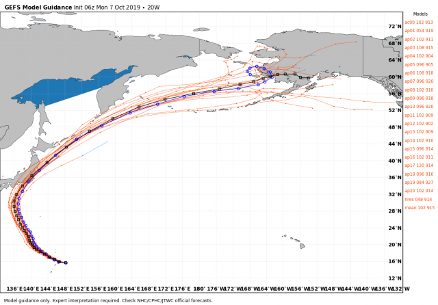
I see an up and down next couple of week with cold fronts sweeping through and a warm up before like 70* range nothing exuberant like we saw last month. All eye remain on what Hagibis, the CAT 5 Typhoon in teh PAC does to our sensible weather when he re curves in the Aleutian Region towards the later part of Rocktober. This usually means a -EPO and + PNA which will drop a trough and how deep it gets remains to be seen over the NE.
Recurvin typhoon - old map but still shows the idea
Pattern
Trough builds east next week

Idea on Temps

Brief Warm Up Next weekend

Oranges over us denote high pressure and blues indicating trough over teh west - another snowstorm/blizzard for them - possibly!!

Typhoon pumps the Hagebabah effects here end of the month as a trouh developes over the GL and NE

Lake effect snows????? I see them in my Mugs Snow Globe LOL!!

SUN UPDATE
Sun is dim
Spotless Days
Current Stretch: 8 days
2019 total: 207 days (73%)
2018 total: 221 days (61%)
2017 total: 104 days (28%)
2016 total: 32 days (9%)
2015 total: 0 days (0%)
2014 total: 1 day (<1%)
2013 total: 0 days (0%)
2012 total: 0 days (0%)
2011 total: 2 days (<1%)
2010 total: 51 days (14%)
2009 total: 260 days (71%)
2008 total: 268 days (73%)
2007 total: 152 days (42%)
2006 total: 70 days (19%)
Updated 11 Oct 2019
Thermosphere Climate Index - this is cold and is on par with the 09/10 and 10/11 winters -
today: 4.37x10¹⁰ W Cold
Max: 49.4x10¹⁰ W Hot (10/1957)
Min: 2.05x10¹⁰ W Cold (02/2009)
explanation | more data: gfx, txt
Affects from low solar are many like EQ, Volcano eruptions - all teh geomagnetic stuff that no one pays attention to on our spaceship we call planet earth until this happens and then we are like OMG !!! Wake up we've had about a half dozen VEI moderate (3's) eruptions this year and two VEI 5's (Ulman and Shiveluch). You know those pink and purple skies that we are seeing like they saw in Dalton, Eddy and Maunder Minimum's they are called Volcano Skies and why?? Cause the fine particles and aerosols from these have "polluted" teh skies giving us glorious artistic dusk skies.
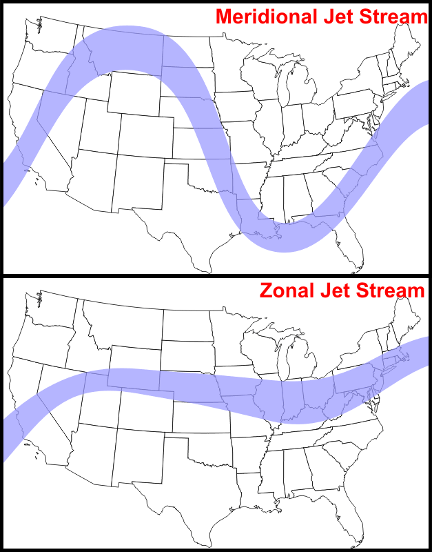
The major affect is meridional jet structure as we are seeing presently and will for some time (years) with big dips in the jet - not zonal as we saw almost all of last winter
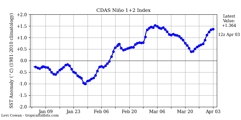
Modoki Nino looking here - cold waters up to region 3.4 and 4
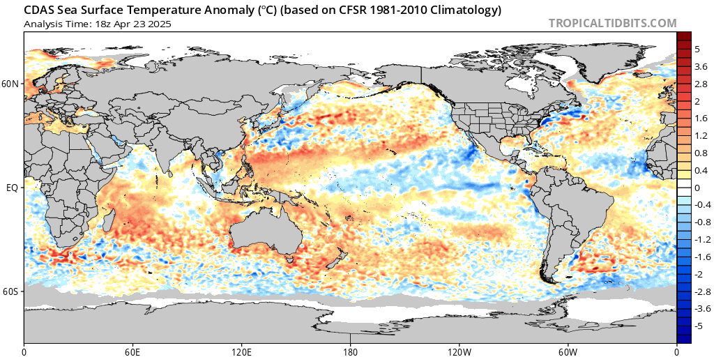
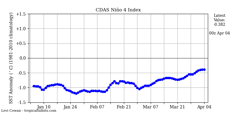
Good sign there and the oceans are lining up as well with a nice warm pool in the EPAC up by Alaska

and around Greenland's western shore
AND the PAC fire hose gets subdued
Middle of Month

END of the Month

So we'll finish plus or AN for the month by about 1* - not going by the concrete jungle temps sorry nor TEB where the asos sensor is on the tarmac - well just at the end by Rt 46 - from the massive abnormal warmth from the first few days.
And Melissa is born - another OTS weak Trop disturbance
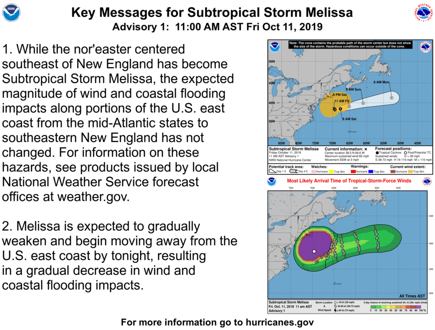
Winds
Ta ta for now peeps!
Okay so where are we going with this month?
I see an up and down next couple of week with cold fronts sweeping through and a warm up before like 70* range nothing exuberant like we saw last month. All eye remain on what Hagibis, the CAT 5 Typhoon in teh PAC does to our sensible weather when he re curves in the Aleutian Region towards the later part of Rocktober. This usually means a -EPO and + PNA which will drop a trough and how deep it gets remains to be seen over the NE.
Recurvin typhoon - old map but still shows the idea

Pattern
Trough builds east next week

Idea on Temps

Brief Warm Up Next weekend

Oranges over us denote high pressure and blues indicating trough over teh west - another snowstorm/blizzard for them - possibly!!

Typhoon pumps the Hagebabah effects here end of the month as a trouh developes over the GL and NE

Lake effect snows????? I see them in my Mugs Snow Globe LOL!!

SUN UPDATE
Sun is dim
Spotless Days
Current Stretch: 8 days
2019 total: 207 days (73%)
2018 total: 221 days (61%)
2017 total: 104 days (28%)
2016 total: 32 days (9%)
2015 total: 0 days (0%)
2014 total: 1 day (<1%)
2013 total: 0 days (0%)
2012 total: 0 days (0%)
2011 total: 2 days (<1%)
2010 total: 51 days (14%)
2009 total: 260 days (71%)
2008 total: 268 days (73%)
2007 total: 152 days (42%)
2006 total: 70 days (19%)
Updated 11 Oct 2019
Thermosphere Climate Index - this is cold and is on par with the 09/10 and 10/11 winters -
today: 4.37x10¹⁰ W Cold
Max: 49.4x10¹⁰ W Hot (10/1957)
Min: 2.05x10¹⁰ W Cold (02/2009)
explanation | more data: gfx, txt
Affects from low solar are many like EQ, Volcano eruptions - all teh geomagnetic stuff that no one pays attention to on our spaceship we call planet earth until this happens and then we are like OMG !!! Wake up we've had about a half dozen VEI moderate (3's) eruptions this year and two VEI 5's (Ulman and Shiveluch). You know those pink and purple skies that we are seeing like they saw in Dalton, Eddy and Maunder Minimum's they are called Volcano Skies and why?? Cause the fine particles and aerosols from these have "polluted" teh skies giving us glorious artistic dusk skies.
The major affect is meridional jet structure as we are seeing presently and will for some time (years) with big dips in the jet - not zonal as we saw almost all of last winter

Modoki Nino looking here - cold waters up to region 3.4 and 4


Good sign there and the oceans are lining up as well with a nice warm pool in the EPAC up by Alaska

and around Greenland's western shore
AND the PAC fire hose gets subdued
Middle of Month

END of the Month

So we'll finish plus or AN for the month by about 1* - not going by the concrete jungle temps sorry nor TEB where the asos sensor is on the tarmac - well just at the end by Rt 46 - from the massive abnormal warmth from the first few days.
And Melissa is born - another OTS weak Trop disturbance

Winds

Ta ta for now peeps!
_________________
Mugs
AKA:King: Snow Weenie
Self Proclaimed
WINTER 2014-15 : 55.12" +.02 for 6 coatings (avg. 35")
WINTER 2015-16 Total - 29.8" (Avg 35")
WINTER 2016-17 : 39.5" so far

amugs- Advanced Forecaster - Mod

- Posts : 15095
Reputation : 213
Join date : 2013-01-07
Age : 54
Location : Hillsdale,NJ
 Re: October Discussion & Observations
GFS shows first snowflakes of the year in Northwest NJ and the Hudson Valley around October 25. Getting closer every day.

billg315- Advanced Forecaster - Mod

- Posts : 4483
Reputation : 185
Join date : 2015-01-24
Age : 50
Location : Flemington, NJ
 Re: October Discussion & Observations
Surprised that a truly tropical storm actually developed out of this lp. We have 65 mph Melissa now moving ssw. A very odd movement for up here.

jmanley32- Senior Enthusiast

- Posts : 20535
Reputation : 108
Join date : 2013-12-12
Age : 43
Location : Yonkers, NY
 Re: October Discussion & Observations
I don’t think I buy the relatively brief death ridge being advertised for the Day 8-12 period, but I need to better analyze things first before I can officially endorse that stance lol doesn’t seem to be supported by the larger synoptic and hemispheric evolution, in my opinion, and what I think ends up occurring may be more of a trough split out west where one piece retrogrades southwestward over the Rockies and beyond, while the other slices into the northern part of the ridge to lead the time-mean trough’s propagation into eastern North America (at least for a time). This would lead to neutral/negative temperature departures as far south as the northern Mid-Atlantic. More discussion to come as my schedule permits......
rb924119- Meteorologist

- Posts : 6928
Reputation : 194
Join date : 2013-02-06
Age : 32
Location : Greentown, Pa
Page 2 of 8 •  1, 2, 3, 4, 5, 6, 7, 8
Permissions in this forum:
You cannot reply to topics in this forum|
|
|

 Home
Home