Long Range Thread 19.0
+38
essexcountypete
SoulSingMG
Scullybutcher
phil155
bobjohnsonforthehall
Zhukov1945
dsix85
Radz
lja
Grselig
devsman
DAYBLAZER
Irish
Dunnzoo
jimv45
sabamfa
SENJsnowman
frank 638
heehaw453
skinsfan1177
sroc4
hyde345
CPcantmeasuresnow
Math23x7
nutleyblizzard
rb924119
weatherwatchermom
aiannone
jmanley32
billg315
dkodgis
Snow88
algae888
docstox12
HectorO
mwilli
amugs
Frank_Wx
42 posters
Page 5 of 28
Page 5 of 28 •  1, 2, 3, 4, 5, 6 ... 16 ... 28
 Re: Long Range Thread 19.0
Actually, I don’t think I have my dates right. When was that suppressed storm last year early in the season?
rb924119- Meteorologist

- Posts : 6928
Join date : 2013-02-06
 Re: Long Range Thread 19.0
It was December 8th—10th, so I’ll have to double check my earlier thoughts and make corrections later, if needed.
rb924119- Meteorologist

- Posts : 6928
Join date : 2013-02-06
 Re: Long Range Thread 19.0
Ray on the woot woot train baby.
5hat was early Dec and they got hanner2e with an ice and historic snowstorm if ya'll (southern slang here) goootcha(get it)
5hat was early Dec and they got hanner2e with an ice and historic snowstorm if ya'll (southern slang here) goootcha(get it)
_________________
Mugs
AKA:King: Snow Weenie
Self Proclaimed
WINTER 2014-15 : 55.12" +.02 for 6 coatings (avg. 35")
WINTER 2015-16 Total - 29.8" (Avg 35")
WINTER 2016-17 : 39.5" so far

amugs- Advanced Forecaster - Mod

- Posts : 15095
Reputation : 213
Join date : 2013-01-07
Age : 54
Location : Hillsdale,NJ
 Re: Long Range Thread 19.0
amugs wrote:Ray on the woot woot train baby.
5hat was early Dec and they got hanner2e with an ice and historic snowstorm if ya'll (southern slang here) goootcha(get it)
Not quite yet, Mugsy, BUT my interest has been piqued for sure! Gotta wait until I can sit down later this weekend and really think on it a bit.
rb924119- Meteorologist

- Posts : 6928
Reputation : 194
Join date : 2013-02-06
Age : 32
Location : Greentown, Pa
 Re: Long Range Thread 19.0
rb924119 wrote:amugs wrote:Ray on the woot woot train baby.
5hat was early Dec and they got hanner2e with an ice and historic snowstorm if ya'll (southern slang here) goootcha(get it)
Not quite yet, Mugsy, BUT my interest has been piqued for sure! Gotta wait until I can sit down later this weekend and really think on it a bit.
IF it plays out like I think it CAN/MIGHT, it COULD be our first Godzilla+ on the season
rb924119- Meteorologist

- Posts : 6928
Reputation : 194
Join date : 2013-02-06
Age : 32
Location : Greentown, Pa
 Re: Long Range Thread 19.0
rb924119 wrote:rb924119 wrote:amugs wrote:Ray on the woot woot train baby.
5hat was early Dec and they got hanner2e with an ice and historic snowstorm if ya'll (southern slang here) goootcha(get it)
Not quite yet, Mugsy, BUT my interest has been piqued for sure! Gotta wait until I can sit down later this weekend and really think on it a bit.
IF it plays out like I think it CAN/MIGHT, it COULD be our first Godzilla+ on the season
Actually second for some of us on this board.

hyde345- Pro Enthusiast

- Posts : 1082
Reputation : 48
Join date : 2013-01-08
Location : Hyde Park, NY
 Re: Long Range Thread 19.0
hyde345 wrote:rb924119 wrote:rb924119 wrote:amugs wrote:Ray on the woot woot train baby.
5hat was early Dec and they got hanner2e with an ice and historic snowstorm if ya'll (southern slang here) goootcha(get it)
Not quite yet, Mugsy, BUT my interest has been piqued for sure! Gotta wait until I can sit down later this weekend and really think on it a bit.
IF it plays out like I think it CAN/MIGHT, it COULD be our first Godzilla+ on the season
Actually second for some of us on this board.
You just HAD to go there, didn’t you?

rb924119- Meteorologist

- Posts : 6928
Reputation : 194
Join date : 2013-02-06
Age : 32
Location : Greentown, Pa
rb924119- Meteorologist

- Posts : 6928
Reputation : 194
Join date : 2013-02-06
Age : 32
Location : Greentown, Pa
 Re: Long Range Thread 19.0
Still gun shy over last winter??rb924119 wrote:amugs wrote:Ray on the woot woot train baby.
5hat was early Dec and they got hanner2e with an ice and historic snowstorm if ya'll (southern slang here) goootcha(get it)
Not quite yet, Mugsy, BUT my interest has been piqued for sure! Gotta wait until I can sit down later this weekend and really think on it a bit.
It's coming, low solae, Mike P and Math say so.
_________________
Mugs
AKA:King: Snow Weenie
Self Proclaimed
WINTER 2014-15 : 55.12" +.02 for 6 coatings (avg. 35")
WINTER 2015-16 Total - 29.8" (Avg 35")
WINTER 2016-17 : 39.5" so far

amugs- Advanced Forecaster - Mod

- Posts : 15095
Reputation : 213
Join date : 2013-01-07
Age : 54
Location : Hillsdale,NJ
 Re: Long Range Thread 19.0
May the ordinary Joe User guy (me) ask:
1) is it looking like snow next Wed?
2) is it looking like snow next weekend (13th-15th)?
We have a family member in the hospital and I may be the only one who has any interest in planning for weather around the daily trips back and forth.
1) is it looking like snow next Wed?
2) is it looking like snow next weekend (13th-15th)?
We have a family member in the hospital and I may be the only one who has any interest in planning for weather around the daily trips back and forth.

dkodgis- Senior Enthusiast

- Posts : 2560
Reputation : 98
Join date : 2013-12-29
 Re: Long Range Thread 19.0
amugs wrote:Still gun shy over last winter??rb924119 wrote:amugs wrote:Ray on the woot woot train baby.
5hat was early Dec and they got hanner2e with an ice and historic snowstorm if ya'll (southern slang here) goootcha(get it)
Not quite yet, Mugsy, BUT my interest has been piqued for sure! Gotta wait until I can sit down later this weekend and really think on it a bit.
It's coming, low solae, Mike P and Math say so.
No, just gunshy because I haven’t been able to do a full analysis, so I don’t want to make any definitive statements until I can do so, but do want to at least discuss which way I’m currently inclined to lean based on what I have looked at. But still subject to change lol you should know by now that if I’m excited about something (or not) I’ll preach until the end ahaha I’m just not able to.......yet lmao also the 9th-12th period is creeping up higher on my priority list as well. So I have two systems to look at lol wouldn’t want it any other way
rb924119- Meteorologist

- Posts : 6928
Reputation : 194
Join date : 2013-02-06
Age : 32
Location : Greentown, Pa
 Re: Long Range Thread 19.0
Not gonna lie, the NAM has me raising my eyebrows bigly for the first event (9th-12th). Dat H5 + jet evolution dohhh!!!
rb924119- Meteorologist

- Posts : 6928
Reputation : 194
Join date : 2013-02-06
Age : 32
Location : Greentown, Pa
 Re: Long Range Thread 19.0
Bernie is pretty jazzed too, just based on what he's seeing in the Euro. He thinks the entire 95 corridor 'could' be in play for Tue-Wed...
https://www.pscp.tv/w/1nAJEZyzQogxL?t=7s&fbclid=IwAR3AJeMafXkJTTkLhDJ3fPKUlNfc_vXw6IGN6wbGfNmb8lfaKZctsx4RW68
https://www.pscp.tv/w/1nAJEZyzQogxL?t=7s&fbclid=IwAR3AJeMafXkJTTkLhDJ3fPKUlNfc_vXw6IGN6wbGfNmb8lfaKZctsx4RW68
SENJsnowman- Senior Enthusiast

- Posts : 1189
Reputation : 61
Join date : 2017-01-06
Age : 51
Location : Bayville, NJ
 Re: Long Range Thread 19.0
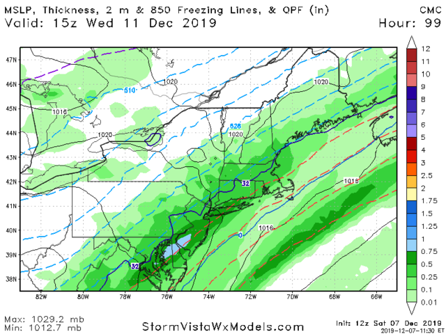
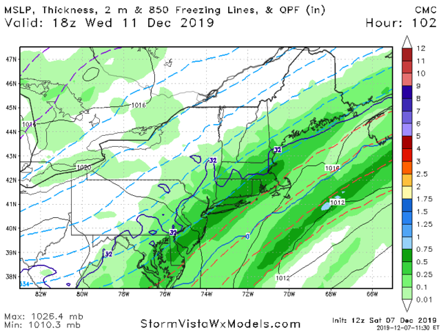
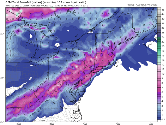
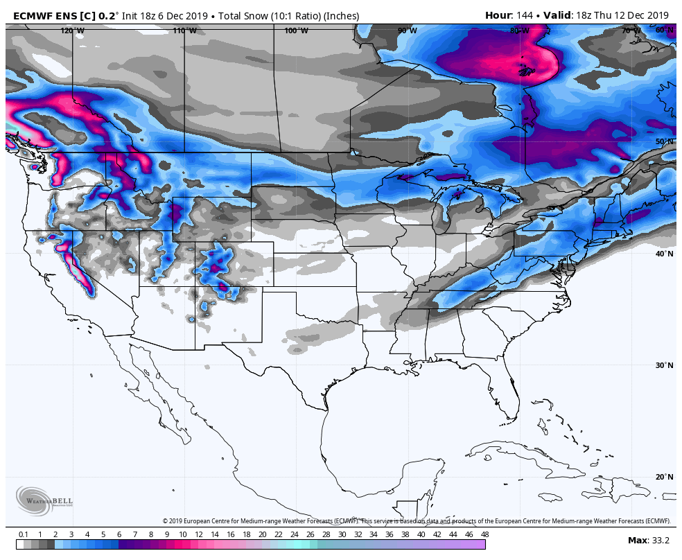
We are in the game for this as per EURO ENS.
Itnis actually energy that is held back and then rounds the base of the trough and ride the front up the coast. Can it get juice?? Possibky but a nice 2-4" event would be a major surprise to many. A 1-3" we would take and run with.
1993-94 at up peeps that BAMWX and Inpostws was preaching about for DEC and JAN.

_________________
Mugs
AKA:King: Snow Weenie
Self Proclaimed
WINTER 2014-15 : 55.12" +.02 for 6 coatings (avg. 35")
WINTER 2015-16 Total - 29.8" (Avg 35")
WINTER 2016-17 : 39.5" so far

amugs- Advanced Forecaster - Mod

- Posts : 15095
Reputation : 213
Join date : 2013-01-07
Age : 54
Location : Hillsdale,NJ
 Re: Long Range Thread 19.0
At face value, I liked what the GFS did with BOTH systems of interest aloft, and really liked what I saw for the second one. The positive anomalies were starting to really be dragged back over the top of the phasing mid-levels. We just lacked the compression from the second northern stream piece. However, I think it made some strides in that department as well. Again, though, all at face value. I’m at work, so I can’t sit and study lol
rb924119- Meteorologist

- Posts : 6928
Reputation : 194
Join date : 2013-02-06
Age : 32
Location : Greentown, Pa
 Re: Long Range Thread 19.0
hyde345 wrote:rb924119 wrote:rb924119 wrote:amugs wrote:Ray on the woot woot train baby.
5hat was early Dec and they got hanner2e with an ice and historic snowstorm if ya'll (southern slang here) goootcha(get it)
Not quite yet, Mugsy, BUT my interest has been piqued for sure! Gotta wait until I can sit down later this weekend and really think on it a bit.
IF it plays out like I think it CAN/MIGHT, it COULD be our first Godzilla+ on the season
Actually second for some of us on this board.
Was just gonna chime in on that Hyde. Everyone always forgets the HV as if our storms never happen. It was pretty much a 10-15 inch event area wide here, 22.6 inches for Math up in Albany, and I believe that qualifies as a Godzilla.
I guess since Ray is in the snow hole of the HV, Fishkill, he may not have received his Godzilla yet.

CPcantmeasuresnow- Wx Statistician Guru

- Posts : 7274
Reputation : 230
Join date : 2013-01-07
Age : 103
Location : Eastern Orange County, NY
 Re: Long Range Thread 19.0
I know Bernie has been saying to keep an eye out for Tuesday night/Wed. I would say a few hours of white rain and that should do it. Maybe well NW can accumulate and inch or two if temps crash fast enough.
This southern energy trails behind and the trough is too flat for much room for energy to sneak in as shown on the GFS. Haven't seen much change in that quite honestly.

2M Temps Euro
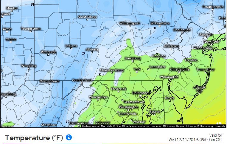
This southern energy trails behind and the trough is too flat for much room for energy to sneak in as shown on the GFS. Haven't seen much change in that quite honestly.

2M Temps Euro

heehaw453- Advanced Forecaster

- Posts : 3906
Reputation : 86
Join date : 2014-01-20
Location : Bedminster Township, PA Elevation 600' ASL
 Re: Long Range Thread 19.0
rb924119 wrote:Fine, our first WIDESPREAD Godzilla+ lol
We appreciate the acknowledgement Ray


CPcantmeasuresnow- Wx Statistician Guru

- Posts : 7274
Reputation : 230
Join date : 2013-01-07
Age : 103
Location : Eastern Orange County, NY
 Re: Long Range Thread 19.0
dkodgis wrote:May the ordinary Joe User guy (me) ask:
1) is it looking like snow next Wed?
2) is it looking like snow next weekend (13th-15th)?
We have a family member in the hospital and I may be the only one who has any interest in planning for weather around the daily trips back and forth.
I’d like to ask about these same days. Wednesday I have a huge catering event for 150 for the nonprofit I work for. So prep is done Tuesday with the event Wednesday. I’m moving next Saturday (Parsippany to Wayne).
sabamfa- Pro Enthusiast

- Posts : 246
Reputation : 2
Join date : 2013-11-05
Age : 38
Location : Wayne, NJ
 Re: Long Range Thread 19.0
Yep Cp I used to be in that snow hole, so Rb didn't get the Godzilla yet like some of us.
jimv45- Senior Enthusiast

- Posts : 1168
Reputation : 36
Join date : 2013-09-20
Location : Hopewell jct.

skinsfan1177- Senior Enthusiast

- Posts : 4485
Reputation : 35
Join date : 2013-01-07
Age : 46
Location : Point Pleasant Boro
 Re: Long Range Thread 19.0
So does the one after it, skins 
rb924119- Meteorologist

- Posts : 6928
Reputation : 194
Join date : 2013-02-06
Age : 32
Location : Greentown, Pa

aiannone- Senior Enthusiast - Mod

- Posts : 4815
Reputation : 92
Join date : 2013-01-07
Location : Saint James, LI (Northwest Suffolk Co.)
 Re: Long Range Thread 19.0
heehaw453 wrote:I know Bernie has been saying to keep an eye out for Tuesday night/Wed. I would say a few hours of white rain and that should do it. Maybe well NW can accumulate and inch or two if temps crash fast enough.
This southern energy trails behind and the trough is too flat for much room for energy to sneak in as shown on the GFS. Haven't seen much change in that quite honestly.
2M Temps Euro
You are just looking at the GFS here which is flatter and more progressive. An accumulating event does have support from other models such as Euro, CMC, and Nam.

hyde345- Pro Enthusiast

- Posts : 1082
Reputation : 48
Join date : 2013-01-08
Location : Hyde Park, NY
 Re: Long Range Thread 19.0
hyde345 wrote:heehaw453 wrote:I know Bernie has been saying to keep an eye out for Tuesday night/Wed. I would say a few hours of white rain and that should do it. Maybe well NW can accumulate and inch or two if temps crash fast enough.
This southern energy trails behind and the trough is too flat for much room for energy to sneak in as shown on the GFS. Haven't seen much change in that quite honestly.
2M Temps Euro
You are just looking at the GFS here which is flatter and more progressive. An accumulating event does have support from other models such as Euro, CMC, and Nam.
I wish I was just being narrow scoped on this threat and just looking at the GFS. The trough is not a sharp one on any of the guidance I've looked at. This leads me to believe energy will have a tough time to come around the base of the trough and form something meaningful.
Just as important we are dealing with a very warm (in the 60s) antecedent air mass and surface temperatures are going to be an issue for any meaningful accumulation. The race between the precip shutoff and the crashing temperatures.
Lastly, these type of setups along and S&E of 95 don't have a good history of producing something meaningful (greater than 1"). Seen this many times before where models show several inches and it winds up with a few hours of white rain. Let's hope this is this falls in the outlier area and produces. Certainly worth watching, but not expecting anything from it.
heehaw453- Advanced Forecaster

- Posts : 3906
Reputation : 86
Join date : 2014-01-20
Location : Bedminster Township, PA Elevation 600' ASL
 Re: Long Range Thread 19.0
sabamfa wrote:dkodgis wrote:May the ordinary Joe User guy (me) ask:
1) is it looking like snow next Wed?
2) is it looking like snow next weekend (13th-15th)?
We have a family member in the hospital and I may be the only one who has any interest in planning for weather around the daily trips back and forth.
I’d like to ask about these same days. Wednesday I have a huge catering event for 150 for the nonprofit I work for. So prep is done Tuesday with the event Wednesday. I’m moving next Saturday (Parsippany to Wayne).
I personally am not ready to comment definitively on either, but maybe somebody else has some further insight they can offer? Paging our resident experts! Lol
rb924119- Meteorologist

- Posts : 6928
Reputation : 194
Join date : 2013-02-06
Age : 32
Location : Greentown, Pa
 Re: Long Range Thread 19.0
sabamfa wrote:dkodgis wrote:May the ordinary Joe User guy (me) ask:
1) is it looking like snow next Wed?
2) is it looking like snow next weekend (13th-15th)?
We have a family member in the hospital and I may be the only one who has any interest in planning for weather around the daily trips back and forth.
I’d like to ask about these same days. Wednesday I have a huge catering event for 150 for the nonprofit I work for. So prep is done Tuesday with the event Wednesday. I’m moving next Saturday (Parsippany to Wayne).
From Upton and it depends on where you are doing this event. Nothing is in being iron2d out yet. The models at 12Z show a much weaker evolution of this front for sbow but upton has this to say.
Somewhat complex scenario shaping up for early week as an
amplifying long wave trough develops over the lower 48. First, a
warm front riding up the coast, and accompanied by a shortwave
trough embedded in the deep layer SW flow E of the amplifying
longwave trough, should bring a round of moderate to locally
heavy rain on Mon. Think ECMWF is more correct than the GFS
with its axis of heavier rain falling more squarely over the
area rather than to the east, via enhanced lift beneath a
coupled low level convergence/upper level divergence couplet.
Wind forecast tricky as there will be both a strong LLJ present
and low level inversion to prevent stronger winds from reaching
the sfc except perhaps in heavier precip accompanying warm fropa
late day or early evening. Have mentioned slight chance thunder
mainly for the metro area and Long Island with models showing
some elevated instability and TT nearing 50.
Once we get into the warm sector, precip chances should diminish
going into overnight Mon night into Tue morning, then increase
with cold fropa Tue night. This second round of steady precip
will likely be anafrontal in nature given, lagging behind cold
fropa given the lagging mid level trough and anticyclonic upper
level jet streak approaching from the west. In this scenario,
precip should change to a period of snow from late Tue night
into Wed especially north/west, as colder air pours in,
especially north/west of NYC where a couple of inches
accumulation appears likely, and lesser amts toward the coast.
The slower/wetter ECMWF cold fropa suggests a possible worst
case of advy level snowfall inland, and maybe an inch or two for
NYC metro and the coast.
_________________
Mugs
AKA:King: Snow Weenie
Self Proclaimed
WINTER 2014-15 : 55.12" +.02 for 6 coatings (avg. 35")
WINTER 2015-16 Total - 29.8" (Avg 35")
WINTER 2016-17 : 39.5" so far

amugs- Advanced Forecaster - Mod

- Posts : 15095
Reputation : 213
Join date : 2013-01-07
Age : 54
Location : Hillsdale,NJ
Page 5 of 28 •  1, 2, 3, 4, 5, 6 ... 16 ... 28
Page 5 of 28
Permissions in this forum:
You cannot reply to topics in this forum|
|
|

 Home
Home