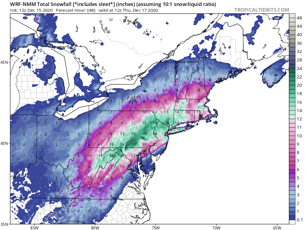
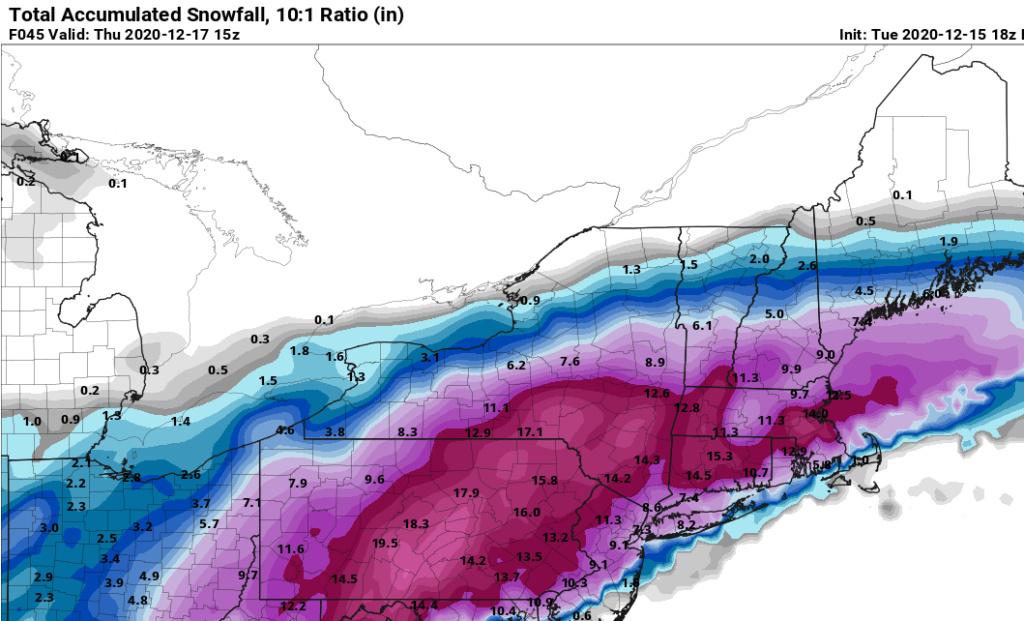
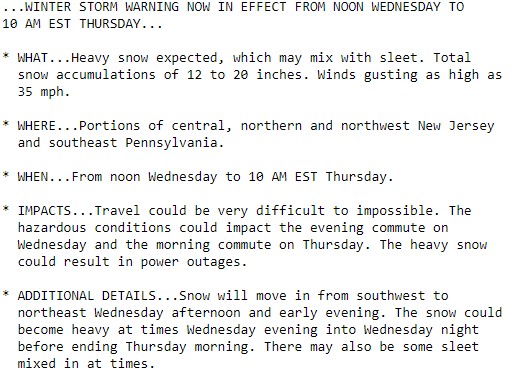
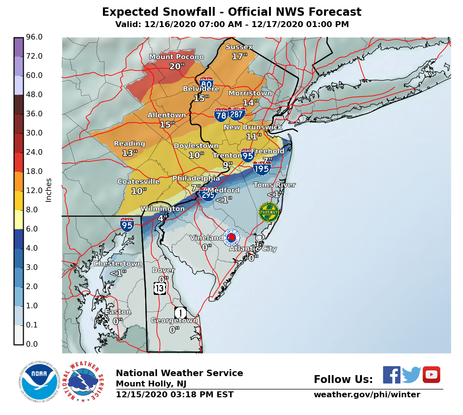
12/16 to 12/17 Godzilla - 1st Call Snow Map
+40
gigs68
WeatherBob
SENJsnowman
Wheezer
Dunnzoo
nutleyblizzard
MattyICE
Irish
bloc1357
RJB8525
rb924119
bobjohnsonforthehall
essexcountypete
elkiehound
DAYBLAZER
crippo84
amugs
heehaw453
sabamfa
CPcantmeasuresnow
sroc4
phil155
docstox12
adamfitz1969
algae888
Math23x7
jimv45
weatherwatchermom
Artechmetals
SoulSingMG
mwilli
billg315
jmanley32
dsix85
Scullybutcher
oldtimer
hyde345
frank 638
aiannone
Frank_Wx
44 posters
Page 9 of 12
Page 9 of 12 •  1, 2, 3 ... 8, 9, 10, 11, 12
 Re: 12/16 to 12/17 Godzilla - 1st Call Snow Map
Irish wrote:TWC just adjusted snow totals for my area in CNJ from 12-18 down to 7-12. Still a very nice storm but the move N&W seems to be happening. Time will tell...
Totals dropped again to 6-10".
Irish- Pro Enthusiast

- Posts : 788
Join date : 2019-01-16
 Re: 12/16 to 12/17 Godzilla - 1st Call Snow Map
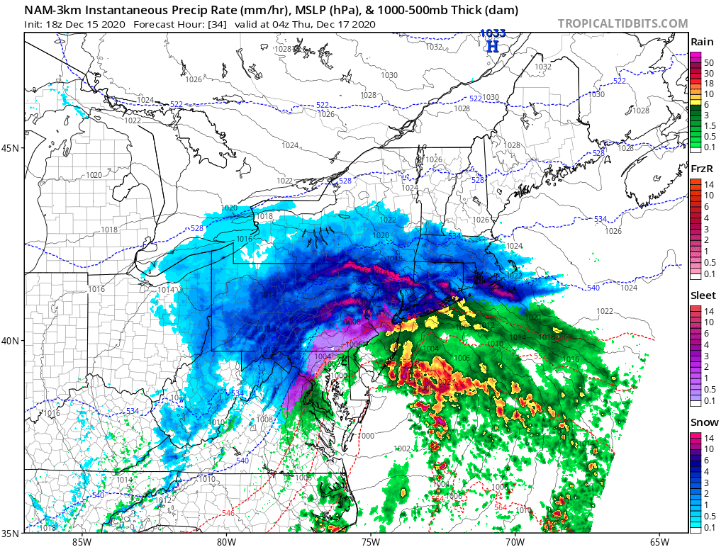
18z NAM so far west it's in the chesapeake
aiannone- Senior Enthusiast - Mod

- Posts : 4815
Join date : 2013-01-07
 Re: 12/16 to 12/17 Godzilla - 1st Call Snow Map
18z Nam- 2-4" LI/NENJ, 4-6" NYC 6-8 NWNJ/Westchester
_________________
-Alex Iannone-

aiannone- Senior Enthusiast - Mod

- Posts : 4815
Reputation : 92
Join date : 2013-01-07
Location : Saint James, LI (Northwest Suffolk Co.)
 Re: 12/16 to 12/17 Godzilla - 1st Call Snow Map
Whats with the LP being over the water then suddenly jumping to the west in chesapeake, lost of sleet for NYC metro even NJ.aiannone wrote:18z NAM so far west it's in the chesapeake

jmanley32- Senior Enthusiast

- Posts : 20535
Reputation : 108
Join date : 2013-12-12
Age : 43
Location : Yonkers, NY
 Re: 12/16 to 12/17 Godzilla - 1st Call Snow Map
I still think this plays some games...we will see. I guess wait and see what tonights runs do and go from there!
bloc1357- Pro Enthusiast

- Posts : 344
Reputation : 10
Join date : 2013-03-05
Age : 47
Location : West Babylon, NY - 11704
 Re: 12/16 to 12/17 Godzilla - 1st Call Snow Map
If there was ever an award for the best attitude on a weather board SENJsnowman wins in a landslide.

CPcantmeasuresnow- Wx Statistician Guru

- Posts : 7274
Reputation : 230
Join date : 2013-01-07
Age : 103
Location : Eastern Orange County, NY
heehaw453- Advanced Forecaster

- Posts : 3906
Reputation : 86
Join date : 2014-01-20
Location : Bedminster Township, PA Elevation 600' ASL
 Re: 12/16 to 12/17 Godzilla - 1st Call Snow Map
CPcantmeasuresnow wrote:
If there was ever an award for the best attitude on a weather board SENJsnowman wins in a landslide.
I agree!
heehaw453- Advanced Forecaster

- Posts : 3906
Reputation : 86
Join date : 2014-01-20
Location : Bedminster Township, PA Elevation 600' ASL
 Re: 12/16 to 12/17 Godzilla - 1st Call Snow Map
_________________
-Alex Iannone-

aiannone- Senior Enthusiast - Mod

- Posts : 4815
Reputation : 92
Join date : 2013-01-07
Location : Saint James, LI (Northwest Suffolk Co.)
 Re: 12/16 to 12/17 Godzilla - 1st Call Snow Map
I actually did not mind the 18z NAM
Yes, still issues with dry slotting and mixing but aloft there were some slight positives
Yes, still issues with dry slotting and mixing but aloft there were some slight positives
_________________
_______________________________________________________________________________________________________
CLICK HERE to view NJ Strong Snowstorm Classifications
 Re: 12/16 to 12/17 Godzilla - 1st Call Snow Map
As many have mentioned, while we’ve been watching the shortwave amplitude over the US, the N Atlantic ULL decided to leave the party out the back door. Watch this 12-run GEFS trend and notice how it trends slowly and steadily further east. pic.twitter.com/xuqXXqq7Gk
— John Homenuk (@jhomenuk) December 15, 2020
_________________
_______________________________________________________________________________________________________
CLICK HERE to view NJ Strong Snowstorm Classifications
 Re: 12/16 to 12/17 Godzilla - 1st Call Snow Map
Frank_Wx wrote:I actually did not mind the 18z NAM
Yes, still issues with dry slotting and mixing but aloft there were some slight positives
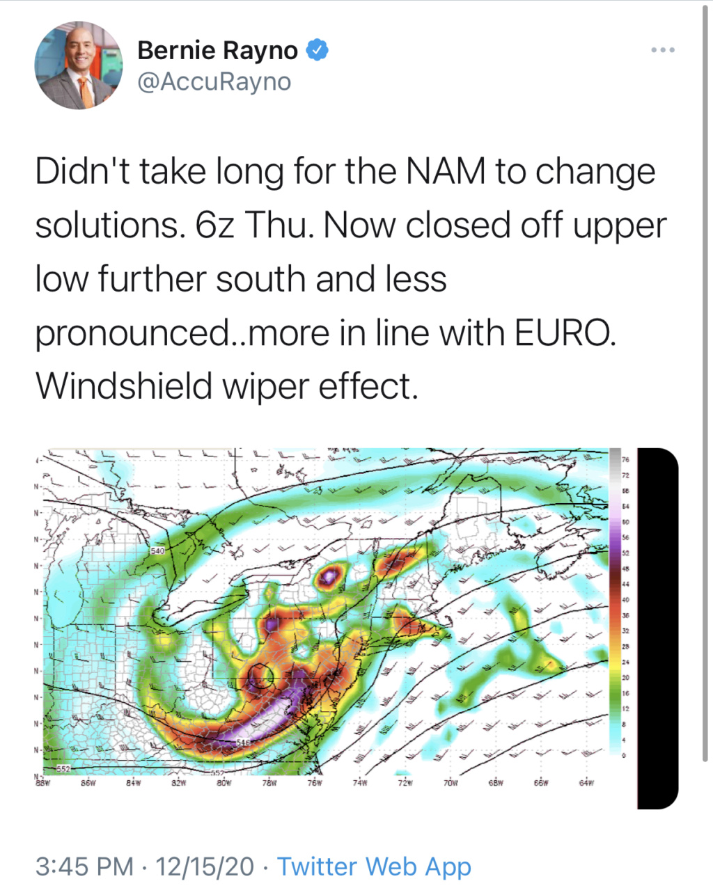
Closed off to early for us which is why we dry slotted but LP was less tucked, kept us colder for the front end thump. didnt really warm until the dry slot
_________________
-Alex Iannone-

aiannone- Senior Enthusiast - Mod

- Posts : 4815
Reputation : 92
Join date : 2013-01-07
Location : Saint James, LI (Northwest Suffolk Co.)
 Re: 12/16 to 12/17 Godzilla - 1st Call Snow Map
Upton's 1:15 PM discussion. Don't be surprised to see a blizzard warning somewhere. Obviously mixing is probably what could stop them from issuing it.
National Weather Service New York NY
115 PM EST Tue Dec 15 2020
SHORT TERM /6 PM THIS EVENING THROUGH THURSDAY/...
As the high pressure shifts east tonight, winds shift out of
the N and NE. Skies will become progressively cloudier through
the night as high cirrus eventually overtake the area. Low
temperatures will be quite chilly, generally in the teens and
low 20s (though NYC may be in the middle to upper 20s). There
may even be some isolated single digit readings in the outlying
areas.
Concerning the major winter storm expected to begin Wednesday
afternoon, not a lot was changed with this update.
Models have been in fairly good agreement on the development of
a surface low pressure along the Mid-Atlantic coast on
Wednesday with the potential for significant impacts to the CWA
from Wednesday afternoon through Thursday in the form of a major
winter storm, but with subtle differences that may affect the
forecast especially closer to the coast.
A strong blocking high to the north will provide cold/dry air
initially. A mid level shortwave trough rounds the base of a
long wave trough over the Tennessee Valley Wednesday morning,
allowing the longwave trough to become slightly negatively
tilted. This combined with an intensifying jet streak to the
north will allow for the rapid intensification of a low pressure
system off of the Carolina coast, positioned in the right
entrance region of the upper level jet streak.
The surface low will move NNE along the Mid Atlantic coastline
and then eastward off the Delmarva Wednesday night into
Thursday. Given the strong Arctic high to the north with
surface and low level temperatures at or below freezing, most
of the area should see an all snow event. The last several runs
of the NAM put this somewhat into doubt with a more amplified
upper trough and stronger mid level jet bringing in warmer air
aloft, also a dry slot late Wed night. With the ECMWF actually
trending colder and remaining slower, did not entirely buy this
scenario except for the lower boroughs of NYC and the south
shore/east end of Long Island.
Winds will increase out of the NE Wednesday evening and
Thursday morning as the tightening pressure gradient will allow
for sustained winds of 25-35 mph possible along the coastline
and gusts 40-50 mph for a time, which may cause close to
blizzard conditions for some.
Where precip remains all snow, potential for over 6 inches of
snow is high, with a medium potential for over a foot of snow.
Amounts may be held down closer to the coast by both wind and
potential for mixing, with lower amounts but still medium
potential for 6 inches of accumulating snow before this occurs.
The main change made with this update was trying to identify the
best potential for any mixing to occur. Though the Twin Forks
likely will mix with rain or sleet at some point, the warm nose
at 850mb was fairly minimal, becoming basically isothermal for a
few hours. This would occur in the middle of the storm so heavy
snow will have already occurred resulting in at least 3-6" of
snow. Obviously the exact intensity of the precipitation and the
ultimate track of the low play a significant role in
determining the strength of the warm nose at 850mb and ultimate
duration and potential to mix or change over to rain, so trends
in models regarding precipitation types will be monitored and
updated accordingly.
There is still some question as to how quickly the low will
pull out late Wed night into Thu. Sided more with ECMWF idea of
light snow in the morning, gradually tapering off from W to E
through the day.
heehaw453- Advanced Forecaster

- Posts : 3906
Reputation : 86
Join date : 2014-01-20
Location : Bedminster Township, PA Elevation 600' ASL
 Re: 12/16 to 12/17 Godzilla - 1st Call Snow Map
Warnings are starting to pop up. NWS as of now is still holding on strong to 12-18 (I live on the west side of Manhattan) with their forecast update. TWC is still riding all snow.
These are the times where you gotta love (or hate) the 4th quarter of a close game. I Was up by 10 when it started but now up only a field goal and they're driving down the field approaching the 2 min warning.
These are the times where you gotta love (or hate) the 4th quarter of a close game. I Was up by 10 when it started but now up only a field goal and they're driving down the field approaching the 2 min warning.
Last edited by crippo84 on Tue Dec 15, 2020 3:43 pm; edited 1 time in total
crippo84- Posts : 383
Reputation : 20
Join date : 2013-11-07
Age : 40
Location : East Village, NYC

SoulSingMG- Senior Enthusiast

- Posts : 2853
Reputation : 74
Join date : 2013-12-11
Location : Long Island City, NY
 Re: 12/16 to 12/17 Godzilla - 1st Call Snow Map
Upton just issued warnings, Im rather shocked its for 12-16 inches. they mention heavy wet snow 45mph winds and power outages.

jmanley32- Senior Enthusiast

- Posts : 20535
Reputation : 108
Join date : 2013-12-12
Age : 43
Location : Yonkers, NY
 Re: 12/16 to 12/17 Godzilla - 1st Call Snow Map
URGENT - WINTER WEATHER MESSAGE
National Weather Service New York NY
340 PM EST Tue Dec 15 2020
CTZ011-012-NYZ078>081-179-161200-
/O.CON.KOKX.WS.A.0001.201216T1900Z-201217T1800Z/
Southern Middlesex-Southern New London-Northwestern Suffolk-
Northeastern Suffolk-Southwestern Suffolk-Southeastern Suffolk-
Southern Nassau-
340 PM EST Tue Dec 15 2020
...WINTER STORM WATCH REMAINS IN EFFECT FROM WEDNESDAY AFTERNOON
THROUGH THURSDAY AFTERNOON...
* WHAT...Heavy snow possible. Total snow accumulations of 3 to 10
inches possible. Winds could gust as high as 50 mph.
* WHERE...Portions of southern Connecticut and southeast New
York.
* WHEN...From Wednesday afternoon through Thursday afternoon.
* IMPACTS...Travel could be very difficult to impossible. The
hazardous conditions could impact the morning or evening
commute. Gusty winds could bring down tree branches.
* ADDITIONAL INFORMATION...There is still uncertainty with how
much warm air moves into the area. If warmer air moves into the
region, less snow will be forecast, and a Winter Weather
Advisory would be issued. If colder air moves into the region,
then more snow will be forecast and a Winter Storm Warning will
be issued.
_________________
-Alex Iannone-

aiannone- Senior Enthusiast - Mod

- Posts : 4815
Reputation : 92
Join date : 2013-01-07
Location : Saint James, LI (Northwest Suffolk Co.)
 Re: 12/16 to 12/17 Godzilla - 1st Call Snow Map
Nws for my area
URGENT - WINTER WEATHER MESSAGE
National Weather Service New York NY
340 PM EST Tue Dec 15 2020
CTZ005>010-NJZ002-004-103>108-NYZ067>071-161200-
/O.UPG.KOKX.WS.A.0001.201216T1900Z-201217T1800Z/
/O.NEW.KOKX.WS.W.0001.201216T1900Z-201217T1800Z/
Northern Fairfield-Northern New Haven-Northern Middlesex-
Northern New London-Southern Fairfield-Southern New Haven-
Western Passaic-Eastern Passaic-Western Bergen-Eastern Bergen-
Western Essex-Eastern Essex-Western Union-Eastern Union-Orange-
Putnam-Rockland-Northern Westchester-Southern Westchester-
340 PM EST Tue Dec 15 2020
...WINTER STORM WARNING IN EFFECT FROM 2 PM WEDNESDAY TO 1 PM EST
THURSDAY...
* WHAT...Heavy snow expected. Total snow accumulations of 12 to 16
inches. Winds gusting as high as 45 mph along the coast.
* WHERE...Portions of northeast New Jersey, southern Connecticut
and southeast New York, including the Lower Hudson Valley.
* WHEN...From 2 PM Wednesday to 1 PM EST Thursday.
* IMPACTS...Travel could

algae888- Advanced Forecaster

- Posts : 5311
Reputation : 46
Join date : 2013-02-05
Age : 62
Location : mt. vernon, new york
 Re: 12/16 to 12/17 Godzilla - 1st Call Snow Map
Mayor Deblasio is on he’s mentioning the storm could be really bad the city is probably getting a foot I’m surprised because I thought There’s going to be mixing especially for south of queens and Brooklyn
frank 638- Senior Enthusiast

- Posts : 2843
Reputation : 37
Join date : 2016-01-01
Age : 40
Location : bronx ny

SoulSingMG- Senior Enthusiast

- Posts : 2853
Reputation : 74
Join date : 2013-12-11
Location : Long Island City, NY

RJB8525- Senior Enthusiast

- Posts : 1994
Reputation : 28
Join date : 2013-02-06
Age : 38
Location : Hackettstown, NJ
 Re: 12/16 to 12/17 Godzilla - 1st Call Snow Map
jmanley32 wrote:Upton just issued warnings, Im rather shocked its for 12-16 inches. they mention heavy wet snow 45mph winds and power outages.
Yeah John they're not buying the short-range models. 7 p.m. tomorrow night per nam dew points below zero in the Hudson Valley and most of Connecticut and in the teens where we live that's not being overcome very easily I don't care how strong the low pressure is. This is an easy 6 in front end thump and I mean easy could easily get to a foot before any dry slot gets in here and then more snows on the back end good call by them

algae888- Advanced Forecaster

- Posts : 5311
Reputation : 46
Join date : 2013-02-05
Age : 62
Location : mt. vernon, new york
 Re: 12/16 to 12/17 Godzilla - 1st Call Snow Map
He also said there will be no more snow days lol, well if your remote thats kinda understandable.frank 638 wrote:Mayor Deblasio is on he’s mentioning the storm could be really bad the city is probably getting a foot I’m surprised because I thought There’s going to be mixing especially for south of queens and Brooklyn

jmanley32- Senior Enthusiast

- Posts : 20535
Reputation : 108
Join date : 2013-12-12
Age : 43
Location : Yonkers, NY
 Re: 12/16 to 12/17 Godzilla - 1st Call Snow Map
That is true let’s hope we have no mixing tomorrow I just want a good old fashion snowstorm for everyonejmanley32 wrote:He also said there will be no more snow days lol, well if your remote thats kinda understandable.frank 638 wrote:Mayor Deblasio is on he’s mentioning the storm could be really bad the city is probably getting a foot I’m surprised because I thought There’s going to be mixing especially for south of queens and Brooklyn
frank 638- Senior Enthusiast

- Posts : 2843
Reputation : 37
Join date : 2016-01-01
Age : 40
Location : bronx ny

RJB8525- Senior Enthusiast

- Posts : 1994
Reputation : 28
Join date : 2013-02-06
Age : 38
Location : Hackettstown, NJ

jmanley32- Senior Enthusiast

- Posts : 20535
Reputation : 108
Join date : 2013-12-12
Age : 43
Location : Yonkers, NY
RJB8525 likes this post

algae888- Advanced Forecaster

- Posts : 5311
Reputation : 46
Join date : 2013-02-05
Age : 62
Location : mt. vernon, new york
Page 9 of 12 •  1, 2, 3 ... 8, 9, 10, 11, 12
Page 9 of 12
Permissions in this forum:
You cannot reply to topics in this forum
 Home
Home