September 2021 Observations and Discussions
+22
Sparky Sparticles
sroc4
dkodgis
brownie
essexcountypete
Joe Snow
crippo84
frank 638
1190ftalt
phil155
SoulSingMG
amugs
sabamfa
rb924119
weatherwatchermom
SENJsnowman
Zhukov1945
jmanley32
Frank_Wx
docstox12
aiannone
billg315
26 posters
Page 1 of 10
Page 1 of 10 • 1, 2, 3, 4, 5, 6, 7, 8, 9, 10 
 September 2021 Observations and Discussions
Cloudy and 69*. September off to a gloomy cool start. Heaviest rain has stayed north and west of my location most of the morning with just some showers here. Expecting a round of heavier rain this evening.

billg315- Advanced Forecaster - Mod

- Posts : 4483
Reputation : 185
Join date : 2015-01-24
Age : 50
Location : Flemington, NJ
 Re: September 2021 Observations and Discussions
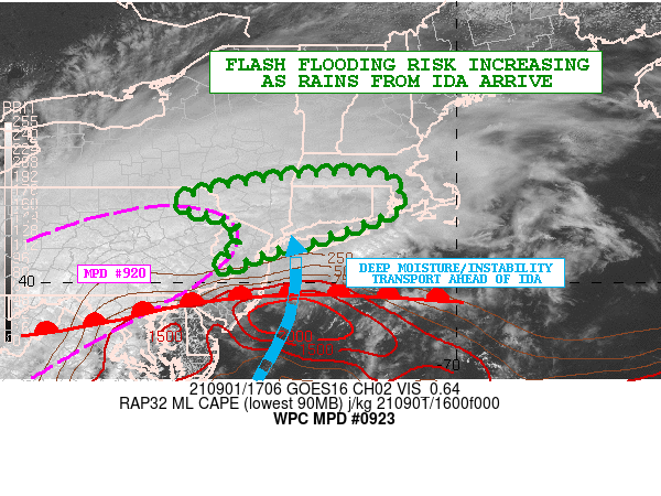
Mesoscale Precipitation Discussion 0923
NWS Weather Prediction Center College Park MD
113 PM EDT Wed Sep 01 2021
Areas affected...Portions of the Northern Mid-Atlantic...Southeast
NY and Southern New England
Concerning...Heavy rainfall...Flash flooding likely
Valid 011712Z - 011930Z
SUMMARY...Heavy rainfall overspreading areas of far northeast PA,
southeast NY, northern NJ and southern New England will increasing
in intensity over the next few hours, with areas of flash flooding
becoming increasingly likely with time.
DISCUSSION...The latest satellite and radar imagery indicates an
expansive area of steady moderate to heavy rain along with some
embedded stronger convective elements impacting areas of far
northeast PA, northern NJ, southeast NY and southern New England.
All of this activity is associated with what is now Post-T.C. Ida.
Very strong frontogenetical forcing and moisture transport is
lifting up across these areas, and with time there will be a
notable increase in the pooling of diurnally aided instability
along a warm front over the central Mid-Atlantic region that will
be advancing northeast toward southern New England going through
the afternoon hours. This will be aided largely by a strengthening
south-southwest low-level jet ahead of Ida's extratropical low
center.
Over the next few hours, there will an increase in the rainfall
intensity and coverage, and the expectation is that there will be
more numerous pockets of locally concentrated convection with very
heavy rainfall rates.
Expect some hourly rainfall rates to begin to approach 2
inches/hour locally, and given the locally heavy rain that has
occurred over the last few hours, some areas of flash flooding
will be gradually likely heading toward the mid to late-afternoon
hours.
Additional heavy rain and much more significant concerns for flash
flooding is expected to evolve by early this evening and heading
into the overnight period. Additional MPDs will be forthcoming
accordingly to address this evolvng threat as Ida approaches the
region.
Orrison
_________________
-Alex Iannone-

aiannone- Senior Enthusiast - Mod

- Posts : 4815
Reputation : 92
Join date : 2013-01-07
Location : Saint James, LI (Northwest Suffolk Co.)
 Re: September 2021 Observations and Discussions
Buckets of rain coming down , breezy.

docstox12- Wx Statistician Guru

- Posts : 8530
Reputation : 222
Join date : 2013-01-07
Age : 73
Location : Monroe NY
 Re: September 2021 Observations and Discussions
Parts of PA already at 5 inches with a lot more left to fall…
_________________
_______________________________________________________________________________________________________
CLICK HERE to view NJ Strong Snowstorm Classifications
 Re: September 2021 Observations and Discussions
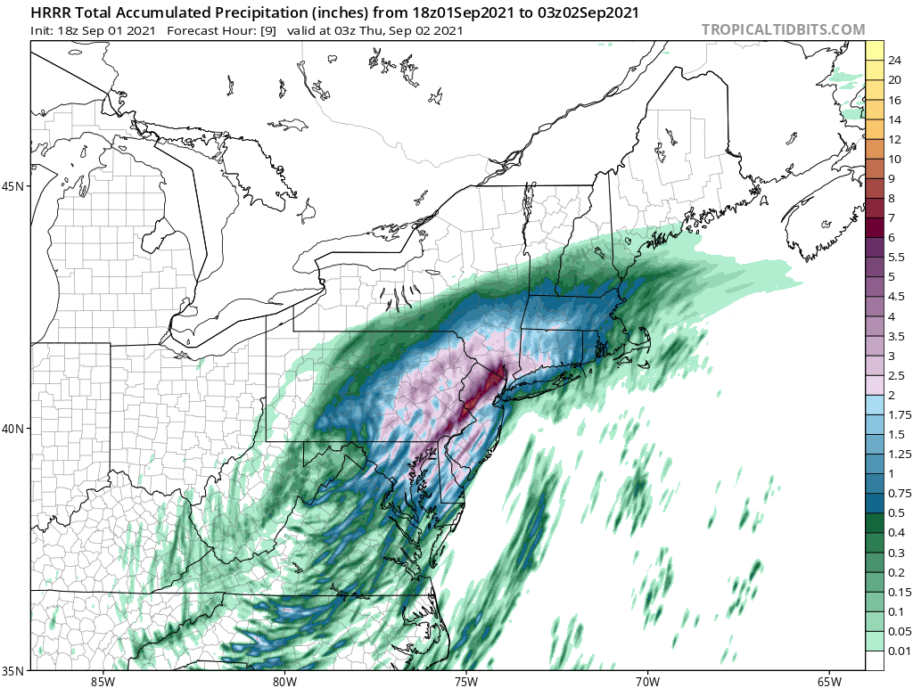
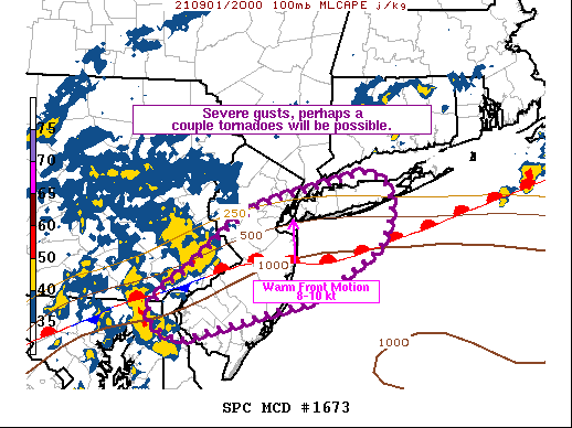
lots of tornado warnings popping south of here, 2 confirmed. thats a lot rain frank wow, HRRR is stil lsteadfast on some pretty crazy amounts in the immediate area, maybe some svr storms too, they inched the spc svr threat a bit further north again.

jmanley32- Senior Enthusiast

- Posts : 20535
Reputation : 108
Join date : 2013-12-12
Age : 43
Location : Yonkers, NY
 Re: September 2021 Observations and Discussions
what up doc, lol. you came out from summer hybernation.docstox12 wrote:Buckets of rain coming down , breezy.

jmanley32- Senior Enthusiast

- Posts : 20535
Reputation : 108
Join date : 2013-12-12
Age : 43
Location : Yonkers, NY
 Re: September 2021 Observations and Discussions
jmanley32 wrote:what up doc, lol. you came out from summer hybernation.docstox12 wrote:Buckets of rain coming down , breezy.
LOL, this storm got me going J man.Here's something to consider, the first flurries up here are around Oct 15th, only 6 weeks away!
Now, back to the regularly scheduled hurricane remnant show.Enjoy it all j man.

docstox12- Wx Statistician Guru

- Posts : 8530
Reputation : 222
Join date : 2013-01-07
Age : 73
Location : Monroe NY
sroc4 and rb924119 like this post

Zhukov1945- Posts : 138
Reputation : 8
Join date : 2018-03-21
Location : Clinton Township NJ
 Re: September 2021 Observations and Discussions
_________________
_______________________________________________________________________________________________________
CLICK HERE to view NJ Strong Snowstorm Classifications
Zhukov1945 likes this post

aiannone- Senior Enthusiast - Mod

- Posts : 4815
Reputation : 92
Join date : 2013-01-07
Location : Saint James, LI (Northwest Suffolk Co.)
 Re: September 2021 Observations and Discussions
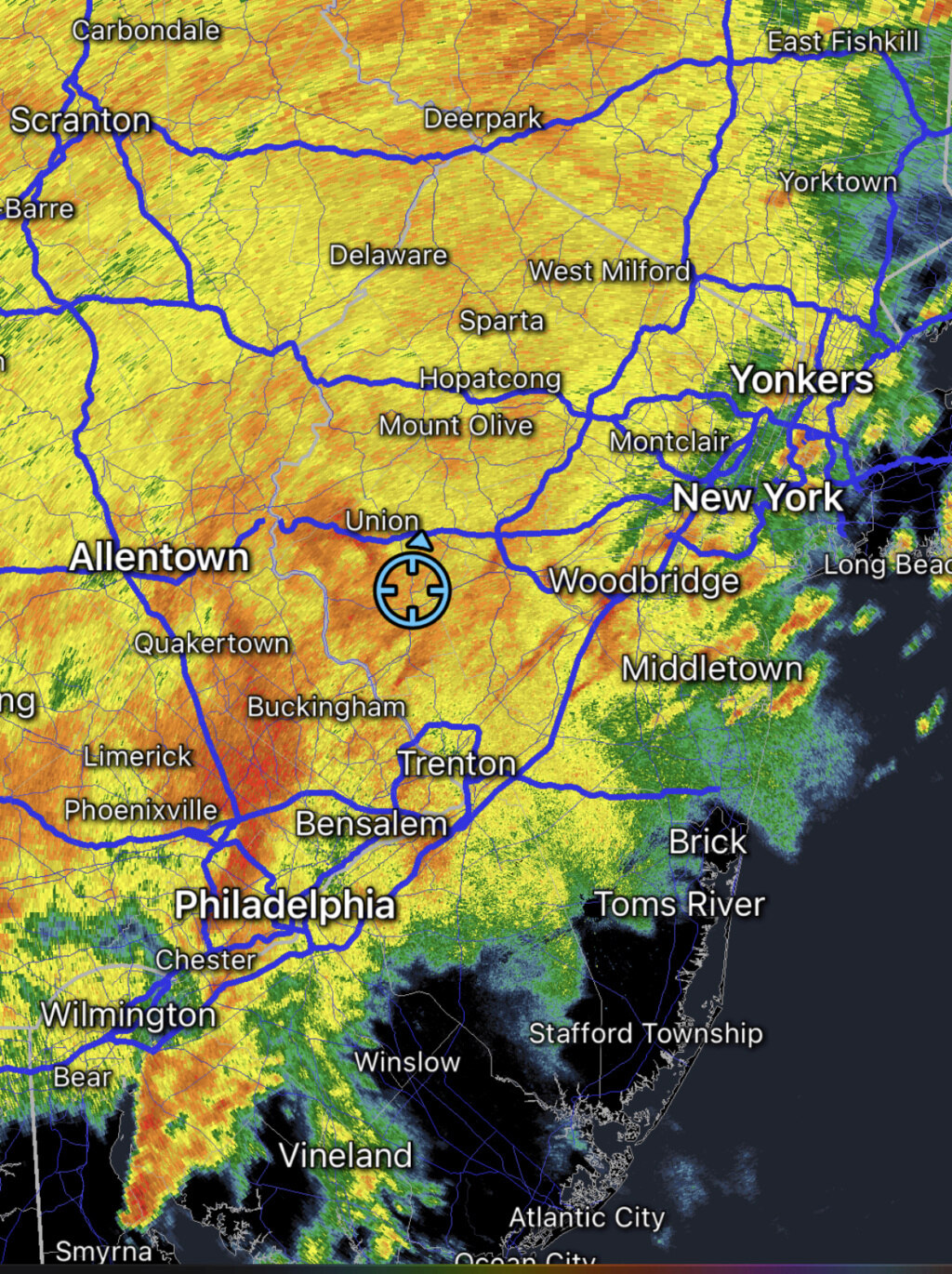
A few miles literally means 4 -5 inches or 6-10 for me. That's going to be impossible to pin point until it happens, if it does. That radar is intense. It would help if any wind or tornado spin ups happened before all that rain because if it is after much hass fallen the rooting of trees is going to be very weak.

jmanley32- Senior Enthusiast

- Posts : 20535
Reputation : 108
Join date : 2013-12-12
Age : 43
Location : Yonkers, NY
 Re: September 2021 Observations and Discussions
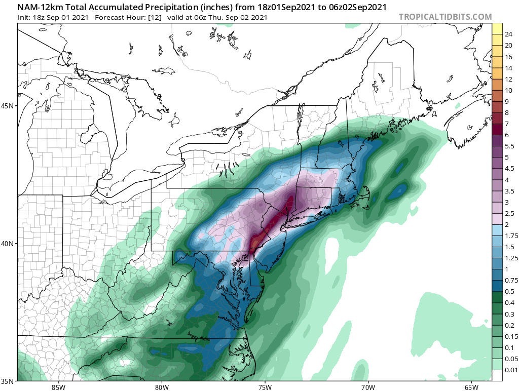
the 18z nam, 19z hrrr and 18z rgem are all bad for NJ and NYC area, all show 4+ inches up to 8 and probably locally even more. the 3km nam radar is as insane as I have seen.

jmanley32- Senior Enthusiast

- Posts : 20535
Reputation : 108
Join date : 2013-12-12
Age : 43
Location : Yonkers, NY
 Re: September 2021 Observations and Discussions
So, it looks like my neck of the woods (Coastal Ocean County, GSP exit 80) has been spared the flood threat, but now sits in the crosshairs of a tornado threat?!  OK, then...I'll let you know if I see anything worth reporting on out there.
SENJsnowman- Senior Enthusiast

- Posts : 1189
Reputation : 61
Join date : 2017-01-06
Age : 51
Location : Bayville, NJ
rb924119 and weatherwatchermom like this post

billg315- Advanced Forecaster - Mod

- Posts : 4483
Reputation : 185
Join date : 2015-01-24
Age : 50
Location : Flemington, NJ
 Re: September 2021 Observations and Discussions
Wow a large and destructive tornado on the ground NW of philly yikes. Just started absolutely pissing rain out (instead of puking for snow, im go say pissing lol) windy and this isnt even the real heavy stuff yet.

jmanley32- Senior Enthusiast

- Posts : 20535
Reputation : 108
Join date : 2013-12-12
Age : 43
Location : Yonkers, NY
 Re: September 2021 Observations and Discussions
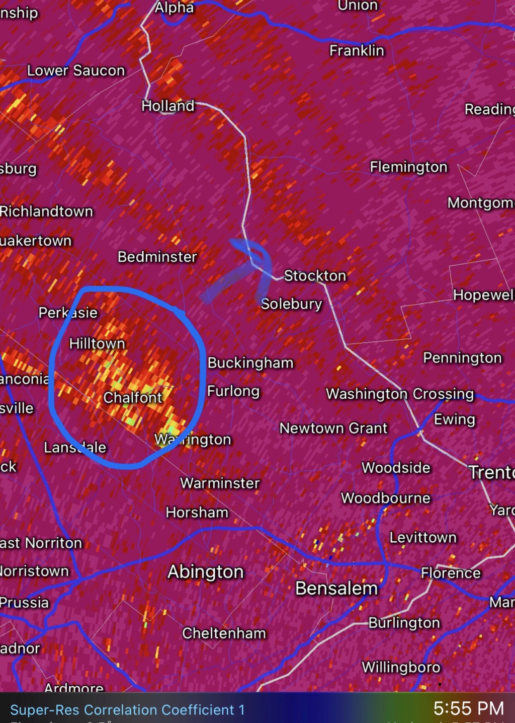
There is a tornado north of Philly in Montgomery/Bucks county. It is headed toward NW NJ in Mercer and Hunterdon counties at about 45 mph. Definitely has my attention as path projection is toward my area.

billg315- Advanced Forecaster - Mod

- Posts : 4483
Reputation : 185
Join date : 2015-01-24
Age : 50
Location : Flemington, NJ

billg315- Advanced Forecaster - Mod

- Posts : 4483
Reputation : 185
Join date : 2015-01-24
Age : 50
Location : Flemington, NJ
 Re: September 2021 Observations and Discussions
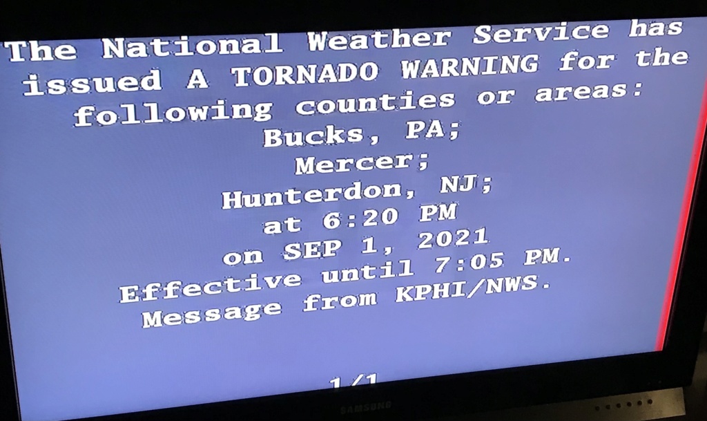
NWS just seized control of TV channels through EBS in my area and issued a Tornado Warning for my location. Have lightning and thunder now too. Warning is for parts of Hunterdon County, Mercer County and Somerset County.

billg315- Advanced Forecaster - Mod

- Posts : 4483
Reputation : 185
Join date : 2015-01-24
Age : 50
Location : Flemington, NJ
 Re: September 2021 Observations and Discussions
well get I'm your basement! That's crazy! Stay safe.billg315 wrote:NWS just seized control of TV channels through EBS in my area and issued a Tornado Warning for my location. Have lightning and thunder now too. Warning is for parts of Hunterdon County, Mercer County and Somerset County.

jmanley32- Senior Enthusiast

- Posts : 20535
Reputation : 108
Join date : 2013-12-12
Age : 43
Location : Yonkers, NY
 Re: September 2021 Observations and Discussions
Stay safe!billg315 wrote:NWS just seized control of TV channels through EBS in my area and issued a Tornado Warning for my location. Have lightning and thunder now too. Warning is for parts of Hunterdon County, Mercer County and Somerset County.

weatherwatchermom- Senior Enthusiast

- Posts : 3793
Reputation : 78
Join date : 2014-11-25
Location : Hazlet Township, NJ
 Re: September 2021 Observations and Discussions
billg315 wrote:NWS just seized control of TV channels through EBS in my area and issued a Tornado Warning for my location. Have lightning and thunder now too. Warning is for parts of Hunterdon County, Mercer County and Somerset County.
Hunker down and let us know you’re ok when able!!
rb924119- Meteorologist

- Posts : 6928
Reputation : 194
Join date : 2013-02-06
Age : 32
Location : Greentown, Pa

billg315- Advanced Forecaster - Mod

- Posts : 4483
Reputation : 185
Join date : 2015-01-24
Age : 50
Location : Flemington, NJ

jmanley32- Senior Enthusiast

- Posts : 20535
Reputation : 108
Join date : 2013-12-12
Age : 43
Location : Yonkers, NY
rb924119- Meteorologist

- Posts : 6928
Reputation : 194
Join date : 2013-02-06
Age : 32
Location : Greentown, Pa
 Re: September 2021 Observations and Discussions
I may be overstating this, but I can't remember rain this heavy and persistent since Irene. It sounds like my building is going through a car wash. And it doesn't let up. There will definitely be flooding issues here.

billg315- Advanced Forecaster - Mod

- Posts : 4483
Reputation : 185
Join date : 2015-01-24
Age : 50
Location : Flemington, NJ
Page 1 of 10 • 1, 2, 3, 4, 5, 6, 7, 8, 9, 10 
Page 1 of 10
Permissions in this forum:
You cannot reply to topics in this forum|
|
|

 Home
Home
