December 2023 Observations and Discussion
+22
brownie
1190ftalt
phil155
frank 638
algae888
deadrabbit79
Frank_Wx
mikeypizano
crippo84
billg315
weatherwatchermom
rb924119
kalleg
jmanley32
SENJsnowman
Dunnzoo
docstox12
dkodgis
aiannone
sroc4
amugs
heehaw453
26 posters
Page 4 of 11
Page 4 of 11 •  1, 2, 3, 4, 5 ... 9, 10, 11
 Re: December 2023 Observations and Discussion
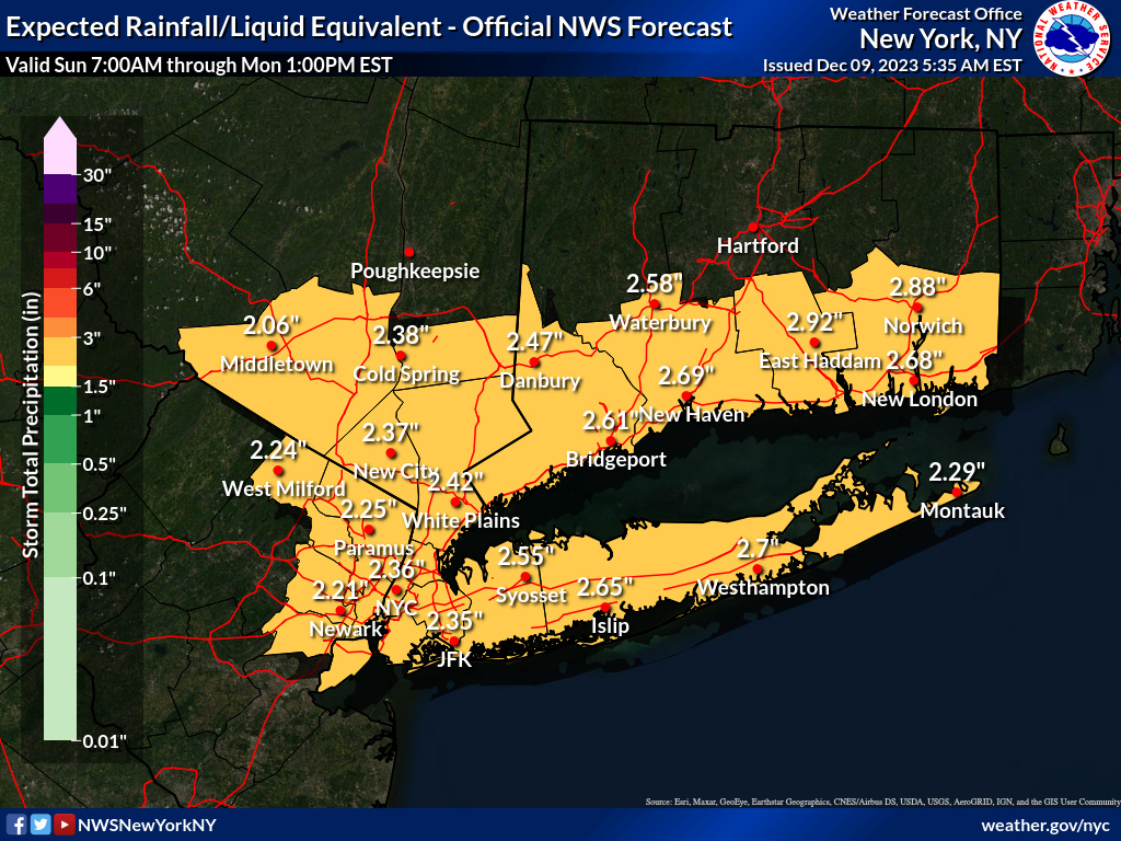
Nws upton increased rain totals to 2 plus for entire area and significantly increased peak wind gusts for example my arwa spot went from 40 mph to 52 mph. Def seems like they are thinking this will be stringer again. Even mentions the chance for snow nw.
jmanley32- Senior Enthusiast

- Posts : 20535
Join date : 2013-12-12
 Re: December 2023 Observations and Discussion
I had a moment to take a look at the impending storm later this weekend, and man this is quite the trough! The energy coming into the CONUS through the PAC NW is very strong. In fact a little too strong. We’re going to see temps ahead of the storm climb into the 60s. That’s because there are actually 2 Pacific upper level short waves semi-close off over the Midwest which causes heights along the east coast to rise
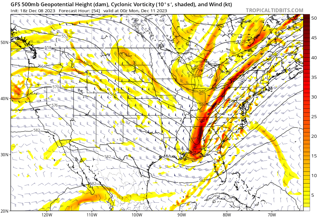
Late Sunday afternoon into evening, we see another upper level short wave drop into the CONUS from Canada. This one catches my eye, because it attempts to phase into the trough which causes the surface low to strengthen and pull down cold air. I’m not thinking the coast will see accumulating snow out of this - mostly because I think the phase doesn’t happen on time (little blocking and collapsing PNA ridge) - but can’t rule it out for interior sections even some close to home N&W of NYC. Right now higher elevations in PA and NY are game for accumulations. Curious to see what happens with models tonight into tomorrow.

Late Sunday afternoon into evening, we see another upper level short wave drop into the CONUS from Canada. This one catches my eye, because it attempts to phase into the trough which causes the surface low to strengthen and pull down cold air. I’m not thinking the coast will see accumulating snow out of this - mostly because I think the phase doesn’t happen on time (little blocking and collapsing PNA ridge) - but can’t rule it out for interior sections even some close to home N&W of NYC. Right now higher elevations in PA and NY are game for accumulations. Curious to see what happens with models tonight into tomorrow.
kalleg and rb924119 like this post
 Re: December 2023 Observations and Discussion
jmanley32 wrote:Nws upton increased rain totals to 2 plus for entire area and significantly increased peak wind gusts for example my arwa spot went from 40 mph to 52 mph. Def seems like they are thinking this will be stringer again. Even mentions the chance for snow nw.
Looks like this will be stronger according to NWS from this morning.Your in the high wind zone, j man, buckle up.Maybe I will see some snow on the back end .Should be a wild ride with this one in the area!
29 degrees, partly cloudy, calm winds.

docstox12- Wx Statistician Guru

- Posts : 8530
Reputation : 222
Join date : 2013-01-07
Age : 73
Location : Monroe NY
 Re: December 2023 Observations and Discussion
Frank_Wx wrote:I had a moment to take a look at the impending storm later this weekend, and man this is quite the trough! The energy coming into the CONUS through the PAC NW is very strong. In fact a little too strong. We’re going to see temps ahead of the storm climb into the 60s. That’s because there are actually 2 Pacific upper level short waves semi-close off over the Midwest which causes heights along the east coast to rise
Late Sunday afternoon into evening, we see another upper level short wave drop into the CONUS from Canada. This one catches my eye, because it attempts to phase into the trough which causes the surface low to strengthen and pull down cold air. I’m not thinking the coast will see accumulating snow out of this - mostly because I think the phase doesn’t happen on time (little blocking and collapsing PNA ridge) - but can’t rule it out for interior sections even some close to home N&W of NYC. Right now higher elevations in PA and NY are game for accumulations. Curious to see what happens with models tonight into tomorrow.
Frank, you beat me to it haha I completely agree, though I actually don’t expect much from this even up here in the Poconos. Maybe Aresian gets into the action a little bit on the back side, but I don’t think this will really work for anybody south of north-central New England. Based on the pattern, I don’t think we see the phase; rather, I think the vorticity maxima/troughs will remain separate until they are north and east of us. The result will be that first we get the precip, then we get the cold air. It’s unfortunate, but there is also time for change haha
rb924119- Meteorologist

- Posts : 6928
Reputation : 194
Join date : 2013-02-06
Age : 32
Location : Greentown, Pa
 Re: December 2023 Observations and Discussion
jmanley32 wrote:So if it is going to head towards negatively tilted scott had posted that NWS had lowered idea of such intense winds so are we looking at possibly above 50mph again. even as high as the GFS which for east of NYC is nuts and would be damaging with a lot of power outages IF it were to occur. That snow is so close to me I would love to see some flakes even if at the end.rb924119 wrote:Meanwhile, the EURO says “Bah humbug, Scrooge you!” lol gotta love it
Didn't that horrible snowstorm that halted traffic in Nov. years ago do something similar? It was exopected to be rain then some snow then 6+ at the last minute?
So, the thing about the trough going negative and increasing the wind threat has to do with enhanced vertical momentum transport thanks to more efficient and stronger forcing for ascent (allowing more vigorous vertical mixing, think of thunderstorms). The stronger the updraft, the more vigorous the downdraft will be to fill the void. And with such a potent low-level jet developing overhead, the stronger the forcing for ascent, the greater the ability to tap into that low-level jet and mix those winds to the surface. However, the more neutral the trough (or more positively tilted/less negatively tilted), the less efficient the forcing for ascent/vertical mixing, which means that there would be more of an inversion-type environment and less effective/vigorous vertical mixing to get the winds from the low-level jet to the surface.
Does that make sense?
Regardless, we should end up with a decent squall line which should yield so higher gusts anyway.
rb924119- Meteorologist

- Posts : 6928
Reputation : 194
Join date : 2013-02-06
Age : 32
Location : Greentown, Pa
 Re: December 2023 Observations and Discussion
rb924119 wrote:Frank_Wx wrote:I had a moment to take a look at the impending storm later this weekend, and man this is quite the trough! The energy coming into the CONUS through the PAC NW is very strong. In fact a little too strong. We’re going to see temps ahead of the storm climb into the 60s. That’s because there are actually 2 Pacific upper level short waves semi-close off over the Midwest which causes heights along the east coast to rise
Late Sunday afternoon into evening, we see another upper level short wave drop into the CONUS from Canada. This one catches my eye, because it attempts to phase into the trough which causes the surface low to strengthen and pull down cold air. I’m not thinking the coast will see accumulating snow out of this - mostly because I think the phase doesn’t happen on time (little blocking and collapsing PNA ridge) - but can’t rule it out for interior sections even some close to home N&W of NYC. Right now higher elevations in PA and NY are game for accumulations. Curious to see what happens with models tonight into tomorrow.
Frank, you beat me to it haha I completely agree, though I actually don’t expect much from this even up here in the Poconos. Maybe Aresian gets into the action a little bit on the back side, but I don’t think this will really work for anybody south of north-central New England. Based on the pattern, I don’t think we see the phase; rather, I think the vorticity maxima/troughs will remain separate until they are north and east of us. The result will be that first we get the precip, then we get the cold air. It’s unfortunate, but there is also time for change haha
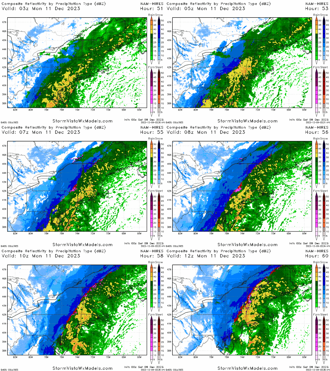
GFS and NAM overnight trended east with the trough, which allows the infiltration of colder air to also move east and bring some good snow into portions of the interior.
_________________
_______________________________________________________________________________________________________
CLICK HERE to view NJ Strong Snowstorm Classifications
 Re: December 2023 Observations and Discussion
Winds at 925mb - 2,500 feet up - are impressive.


_________________
_______________________________________________________________________________________________________
CLICK HERE to view NJ Strong Snowstorm Classifications
jmanley32 likes this post
 Re: December 2023 Observations and Discussion
Yeah, but if you look at H5, they are definitely trending toward the Euro now, and are showing less phasing with each run. Now, on both models, there really isn’t even a phase until the energy is over New England. If that northern stream energy doesn’t get involved, I don’t see how this works out for any meaningful snow. And I don’t see a reason to think that the northern stream energy will get involved in time. I think it’s too late for us to really matter. Some minor accumulations (i.e an inch or two), maybe. But on the whole, I do t think anything significant for our area.
Even the RGEM is headed toward the Euro now with a more progressive system.
Even the RGEM is headed toward the Euro now with a more progressive system.
rb924119- Meteorologist

- Posts : 6928
Reputation : 194
Join date : 2013-02-06
Age : 32
Location : Greentown, Pa
 Re: December 2023 Observations and Discussion
How much rain are we looking at realistically in the NYC metro area? I have heard anywhere from 1 to 3+. Cause I can’t handle another flood. And do those of us getting rain need to worry about icing conditions when the temp drop?
deadrabbit79- Posts : 176
Reputation : 6
Join date : 2013-01-25
Location : Hartsdale, New York
 Re: December 2023 Observations and Discussion
_________________
Janet
Snowfall winter of 2023-2024 17.5"
Snowfall winter of 2022-2023 6.0"
Snowfall winter of 2021-2022 17.6" 1" sleet 2/25/22
Snowfall winter of 2020-2021 51.1"
Snowfall winter of 2019-2020 8.5"
Snowfall winter of 2018-2019 25.1"
Snowfall winter of 2017-2018 51.9"
Snowfall winter of 2016-2017 45.6"
Snowfall winter of 2015-2016 29.5"
Snowfall winter of 2014-2015 50.55"
Snowfall winter of 2013-2014 66.5"
Dunnzoo- Senior Enthusiast - Mod

- Posts : 4905
Reputation : 68
Join date : 2013-01-11
Age : 62
Location : Westwood, NJ
deadrabbit79 and jmanley32 like this post
 Re: December 2023 Observations and Discussion
The 06Z GFS does have a faster consolidation at the H5. That allows for better mid level consolidation and a tilt of the H5 trough. That's the only way there will be accumulating snow in the immediate area IMO. Right now as I've felt this will be several inches of snow for I-81 north of Wilkes Barre. Binghamton I could see at least 4" and of course the Catskills even more. Elevated areas of NW NJ and Poconos in play for a few inches. Wide spread T amounts IMO.


heehaw453- Advanced Forecaster

- Posts : 3906
Reputation : 86
Join date : 2014-01-20
Location : Bedminster Township, PA Elevation 600' ASL
jmanley32 likes this post
 Re: December 2023 Observations and Discussion
deadrabbit79 wrote:How much rain are we looking at realistically in the NYC metro area? I have heard anywhere from 1 to 3+. Cause I can’t handle another flood. And do those of us getting rain need to worry about icing conditions when the temp drop?
Like Dunnz posted, probably somewhere between 1.5-2.5” of rain. No freeze or flash-freeze threat.
rb924119- Meteorologist

- Posts : 6928
Reputation : 194
Join date : 2013-02-06
Age : 32
Location : Greentown, Pa
jmanley32 likes this post
 Re: December 2023 Observations and Discussion
heehaw453 wrote:The 06Z GFS does have a faster consolidation at the H5. That allows for better mid level consolidation and a tilt of the H5 trough. That's the only way there will be accumulating snow in the immediate area IMO. Right now as I've felt this will be several inches of snow for I-81 north of Wilkes Barre. Binghamton I could see at least 4" and of course the Catskills even more. Elevated areas of NW NJ and Poconos in play for a few inches. Wide spread T amounts IMO.
Agree, although I’m going lower for amounts. I don’t think places south of about the latitude of the Mass Pike see anything more than a coating to 3”. Obviously, the elevated areas will do better, and the highest peaks in the Catskills could do better, but on the whole, I really don’t see this as a significant snow threat outside of central and northern New England.
rb924119- Meteorologist

- Posts : 6928
Reputation : 194
Join date : 2013-02-06
Age : 32
Location : Greentown, Pa
jmanley32 likes this post
 Re: December 2023 Observations and Discussion
Man, the NAM is not backing down lol it did a NAM thing again 


rb924119- Meteorologist

- Posts : 6928
Reputation : 194
Join date : 2013-02-06
Age : 32
Location : Greentown, Pa
jmanley32 likes this post
heehaw453- Advanced Forecaster

- Posts : 3906
Reputation : 86
Join date : 2014-01-20
Location : Bedminster Township, PA Elevation 600' ASL
jmanley32 likes this post
 Re: December 2023 Observations and Discussion
Verbatim the snow even wraps briefly into the coast, I don't believe that until I see it. Looks like the high winds are going to be just east of here but only a slight deviation to the west im guessing earlier amplification will build it further west before heading east. What is the sold line of 0 wind? Is there really going to be a sudden calm like a eye of a hurricane but in a line? Don't recall seeing that.rb924119 wrote:Man, the NAM is not backing down lol it did a NAM thing again


jmanley32- Senior Enthusiast

- Posts : 20535
Reputation : 108
Join date : 2013-12-12
Age : 43
Location : Yonkers, NY
 Re: December 2023 Observations and Discussion
As we have said we getting NAM'd lol. I would love to see that happen especially for northern folks, would take a miracle to see flakes down here, it wouldn't stick but still be nice to see it. Saw first flurries on Thursday so it would be second time, both far earlier than last year.

jmanley32- Senior Enthusiast

- Posts : 20535
Reputation : 108
Join date : 2013-12-12
Age : 43
Location : Yonkers, NY
heehaw453 likes this post
 Re: December 2023 Observations and Discussion
It’s interesting because the SREFs, which have the same dynamical core as the NAM, backed off on the snow threat with their latest run, so it’s interesting that the NAM is maintaining its consistency. I’ve seen the NAM score coups in the past, but in this case, I really just don’t see support for it to do what it’s doing. Even the 3k NAM is less bullish. I’m trying to figure out why it’s doing this, but I’m honestly kind of stumped.
rb924119- Meteorologist

- Posts : 6928
Reputation : 194
Join date : 2013-02-06
Age : 32
Location : Greentown, Pa
jmanley32 likes this post
 Re: December 2023 Observations and Discussion
By the looks of that the highest winds miss all but LI? But it also sounds like from Ray's previous post that these will not have a hard time mixing down so these numbers are not all that far off from the truth? Its go be ripping on the cape thats for sure. My friend in eastern CT, almost RI wants to know what the wind will be like he is basically about 20 miles inland durectly north of the forks of LI in CT.Frank_Wx wrote:Winds at 925mb - 2,500 feet up - are impressive.

jmanley32- Senior Enthusiast

- Posts : 20535
Reputation : 108
Join date : 2013-12-12
Age : 43
Location : Yonkers, NY
 Re: December 2023 Observations and Discussion
Now the EURO nodded to the NAM. Which way do we go, George, which way do we go? 


rb924119- Meteorologist

- Posts : 6928
Reputation : 194
Join date : 2013-02-06
Age : 32
Location : Greentown, Pa
Dunnzoo, heehaw453 and Sparky Sparticles like this post
 Re: December 2023 Observations and Discussion
rb924119 wrote:Now the EURO nodded to the NAM. Which way do we go, George, which way do we go?

A Nod or a sarcastic “maybe? I don’t think so you drunk NAM?” Lol
_________________
"In weather and in life, there's no winning and losing; there's only winning and learning."
WINTER 2012/2013 TOTALS 43.65"WINTER 2017/2018 TOTALS 62.85" WINTER 2022/2023 TOTALS 4.9"
WINTER 2013/2014 TOTALS 64.85"WINTER 2018/2019 TOTALS 14.25" WINTER 2023/2024 TOTALS 13.1"
WINTER 2014/2015 TOTALS 71.20"WINTER 2019/2020 TOTALS 6.35"
WINTER 2015/2016 TOTALS 35.00"WINTER 2020/2021 TOTALS 37.75"
WINTER 2016/2017 TOTALS 42.25"WINTER 2021/2022 TOTALS 31.65"

sroc4- Admin

- Posts : 8354
Reputation : 302
Join date : 2013-01-07
Location : Wading River, LI
 Re: December 2023 Observations and Discussion
Hello all. Hope everyone is ok. Rb the nam is forming a coastal low on the front off the NC coast and intensifies as it moves east of Montauk. This throws moisture back to the north west and hence snow for parts of our region. I'm skeptical because it's the only guidance showing this but it has scored coups in the pastrb924119 wrote:It’s interesting because the SREFs, which have the same dynamical core as the NAM, backed off on the snow threat with their latest run, so it’s interesting that the NAM is maintaining its consistency. I’ve seen the NAM score coups in the past, but in this case, I really just don’t see support for it to do what it’s doing. Even the 3k NAM is less bullish. I’m trying to figure out why it’s doing this, but I’m honestly kind of stumped.

algae888- Advanced Forecaster

- Posts : 5311
Reputation : 46
Join date : 2013-02-05
Age : 62
Location : mt. vernon, new york
heehaw453 likes this post
 Re: December 2023 Observations and Discussion
algae888 wrote:Hello all. Hope everyone is ok. Rb the nam is forming a coastal low on the front off the NC coast and intensifies as it moves east of Montauk. This throws moisture back to the north west and hence snow for parts of our region. I'm skeptical because it's the only guidance showing this but it has scored coups in the pastrb924119 wrote:It’s interesting because the SREFs, which have the same dynamical core as the NAM, backed off on the snow threat with their latest run, so it’s interesting that the NAM is maintaining its consistency. I’ve seen the NAM score coups in the past, but in this case, I really just don’t see support for it to do what it’s doing. Even the 3k NAM is less bullish. I’m trying to figure out why it’s doing this, but I’m honestly kind of stumped.
Al! Glad to see you back. Hope all is well. When the NAM scores the coup if I’m not mistaken it’s when there is a big dynamic system. This set up certainly qualifies. We’ll see.
_________________
"In weather and in life, there's no winning and losing; there's only winning and learning."
WINTER 2012/2013 TOTALS 43.65"WINTER 2017/2018 TOTALS 62.85" WINTER 2022/2023 TOTALS 4.9"
WINTER 2013/2014 TOTALS 64.85"WINTER 2018/2019 TOTALS 14.25" WINTER 2023/2024 TOTALS 13.1"
WINTER 2014/2015 TOTALS 71.20"WINTER 2019/2020 TOTALS 6.35"
WINTER 2015/2016 TOTALS 35.00"WINTER 2020/2021 TOTALS 37.75"
WINTER 2016/2017 TOTALS 42.25"WINTER 2021/2022 TOTALS 31.65"

sroc4- Admin

- Posts : 8354
Reputation : 302
Join date : 2013-01-07
Location : Wading River, LI
heehaw453 likes this post
 Re: December 2023 Observations and Discussion
The 18z gfs looks a lot like the nam has snow down to the jersey shore

algae888- Advanced Forecaster

- Posts : 5311
Reputation : 46
Join date : 2013-02-05
Age : 62
Location : mt. vernon, new york
kalleg and SENJsnowman like this post
 Re: December 2023 Observations and Discussion
Algae is back baby!! You know it's real
_________________
Mugs
AKA:King: Snow Weenie
Self Proclaimed
WINTER 2014-15 : 55.12" +.02 for 6 coatings (avg. 35")
WINTER 2015-16 Total - 29.8" (Avg 35")
WINTER 2016-17 : 39.5" so far

amugs- Advanced Forecaster - Mod

- Posts : 15095
Reputation : 213
Join date : 2013-01-07
Age : 54
Location : Hillsdale,NJ
heehaw453 likes this post
 Re: December 2023 Observations and Discussion
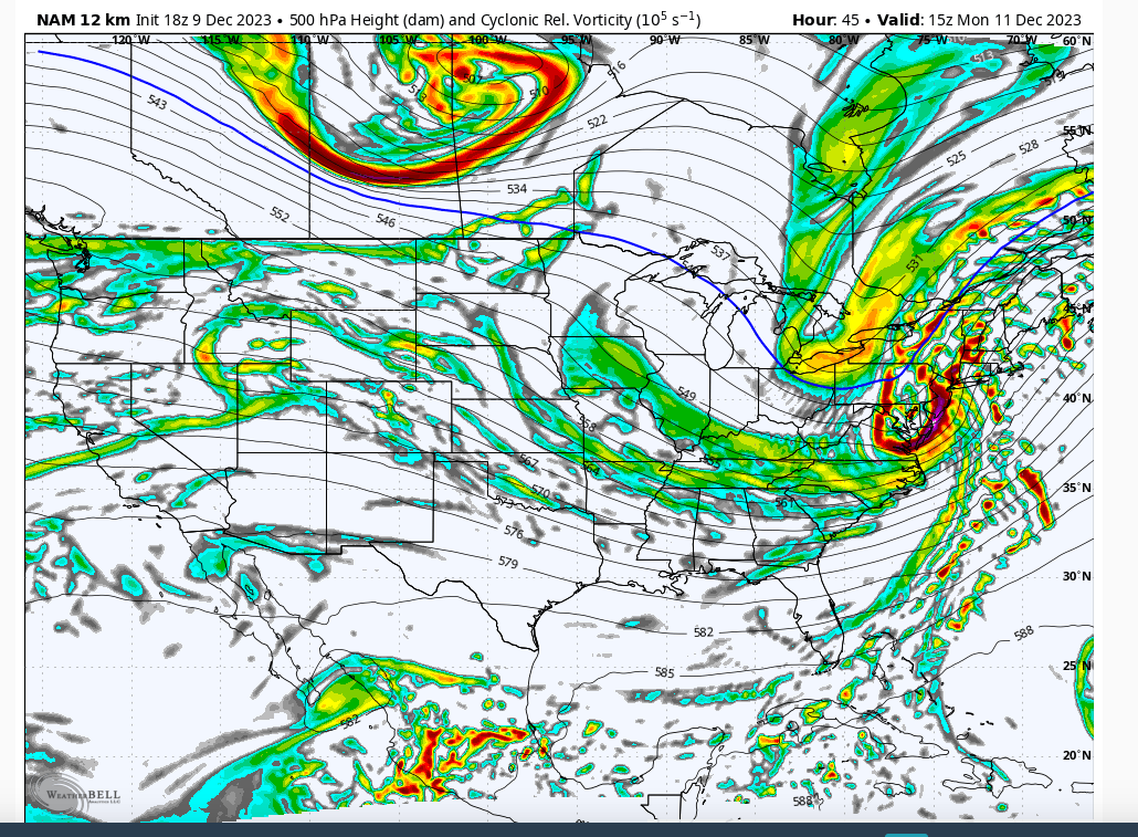
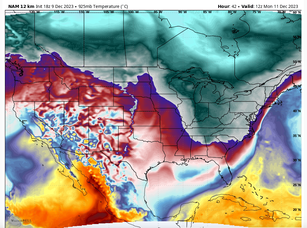
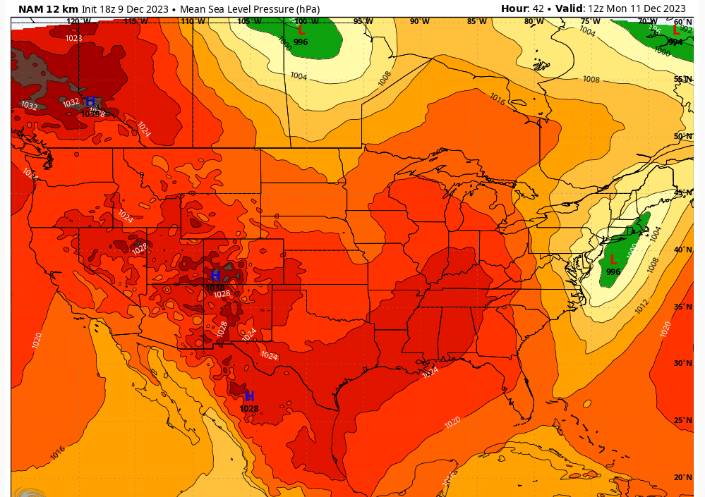
Clearly guidance is going the road of a coastal storm which is how sometimes these anafrontal things can work out. Something needs to keep the precipitation going for these to have a chance. This is probably still evolving to a solution. Neg tilt on the 500mb trough as it hits the coast gives rise to closed off mid level circulation. That slows things down just a hair as the intensification occurs.



heehaw453- Advanced Forecaster

- Posts : 3906
Reputation : 86
Join date : 2014-01-20
Location : Bedminster Township, PA Elevation 600' ASL
sroc4 likes this post
 Re: December 2023 Observations and Discussion
algae888 wrote:The 18z gfs looks a lot like the nam has snow down to the jersey shore
Good to see you!
heehaw453- Advanced Forecaster

- Posts : 3906
Reputation : 86
Join date : 2014-01-20
Location : Bedminster Township, PA Elevation 600' ASL
Page 4 of 11 •  1, 2, 3, 4, 5 ... 9, 10, 11
Page 4 of 11
Permissions in this forum:
You cannot reply to topics in this forum|
|
|

 Home
Home