December 2023 Observations and Discussion
+22
brownie
1190ftalt
phil155
frank 638
algae888
deadrabbit79
Frank_Wx
mikeypizano
crippo84
billg315
weatherwatchermom
rb924119
kalleg
jmanley32
SENJsnowman
Dunnzoo
docstox12
dkodgis
aiannone
sroc4
amugs
heehaw453
26 posters
Page 5 of 11
Page 5 of 11 •  1, 2, 3, 4, 5, 6 ... 9, 10, 11
 Re: December 2023 Observations and Discussion
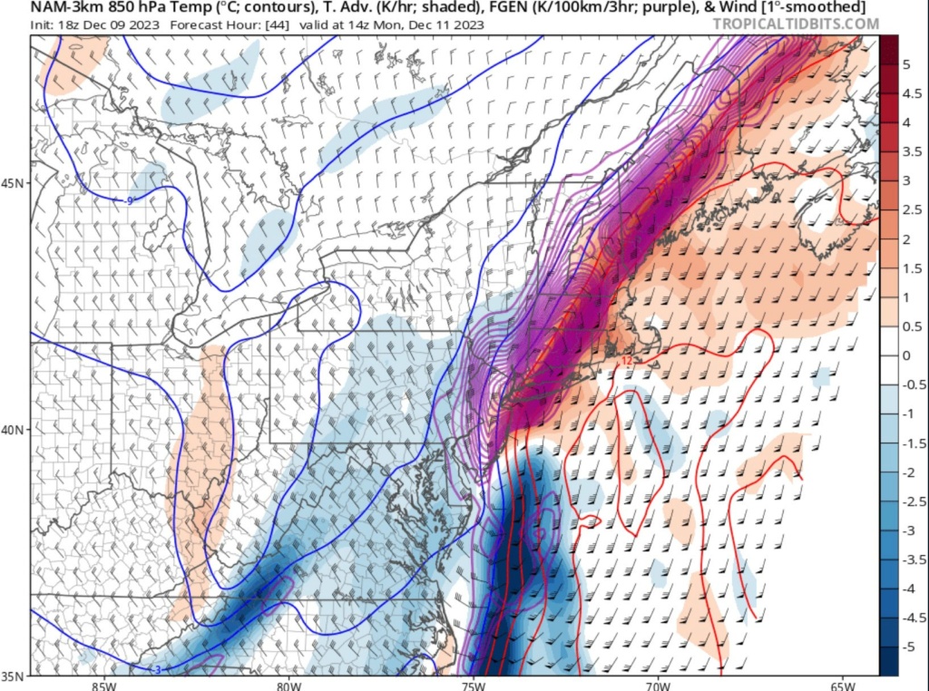
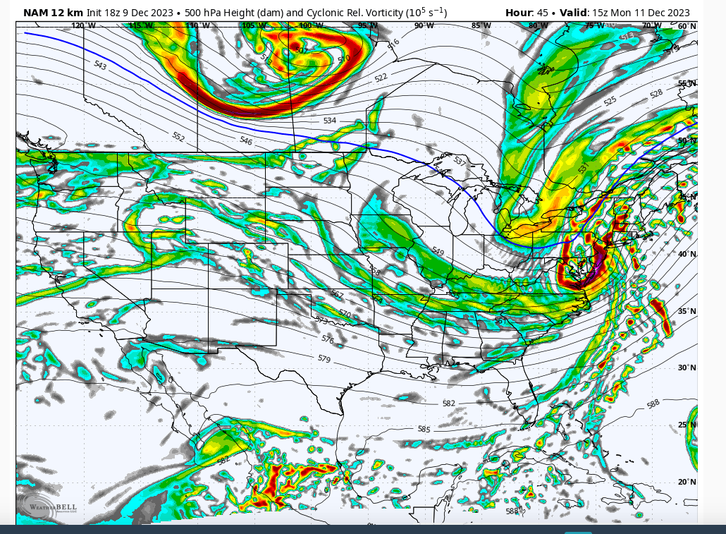
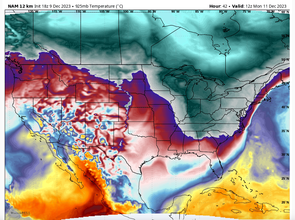
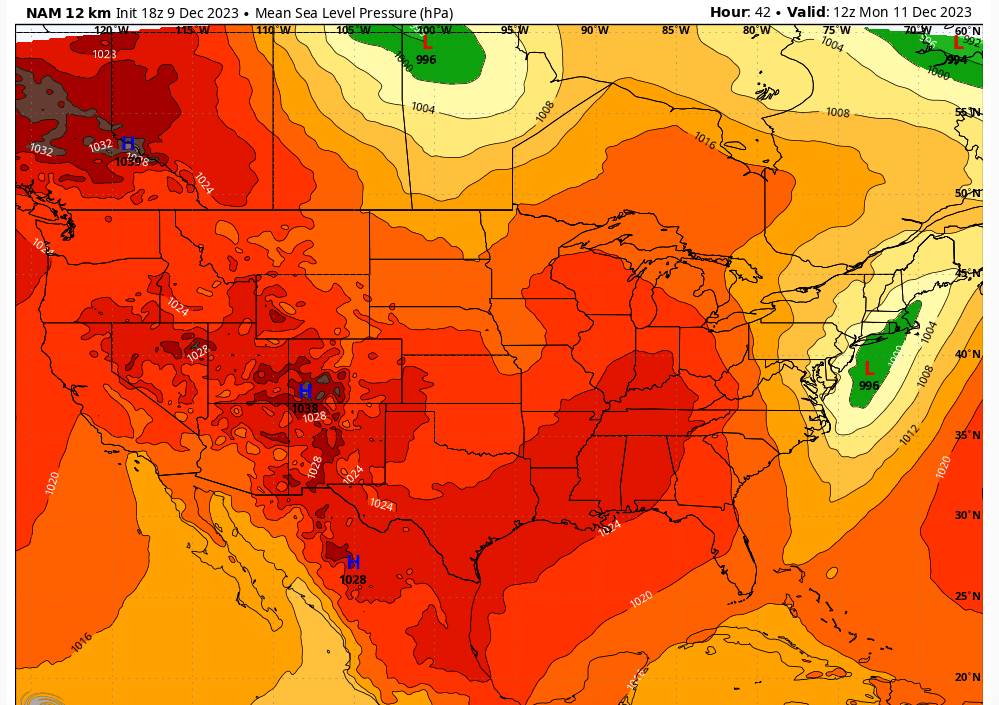
Clearly guidance is going the road of a coastal storm which is how sometimes these anafrontal things can work out. Something needs to keep the precipitation going for these to have a chance. This is probably still evolving to a solution. Neg tilt on the 500mb trough as it hits the coast gives rise to closed off mid level circulation. That slows things down just a hair as the intensification occurs.



heehaw453- Advanced Forecaster

- Posts : 3906
Join date : 2014-01-20
sroc4 likes this post
 Re: December 2023 Observations and Discussion
algae888 wrote:The 18z gfs looks a lot like the nam has snow down to the jersey shore
Good to see you!
heehaw453- Advanced Forecaster

- Posts : 3906
Join date : 2014-01-20
 Re: December 2023 Observations and Discussion
_________________
Mugs
AKA:King: Snow Weenie
Self Proclaimed
WINTER 2014-15 : 55.12" +.02 for 6 coatings (avg. 35")
WINTER 2015-16 Total - 29.8" (Avg 35")
WINTER 2016-17 : 39.5" so far

amugs- Advanced Forecaster - Mod

- Posts : 15095
Reputation : 213
Join date : 2013-01-07
Age : 54
Location : Hillsdale,NJ
 Re: December 2023 Observations and Discussion
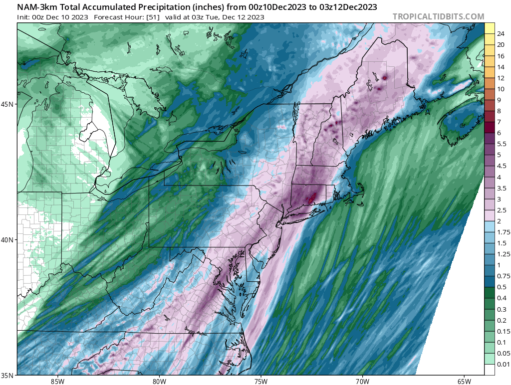
This system is really juiced up that looks impressive. I think we may see some severem t-storms out of the line. And I am guessing flooding rins to the S & E right, well I hope the north cashes in.

jmanley32- Senior Enthusiast

- Posts : 20535
Reputation : 108
Join date : 2013-12-12
Age : 43
Location : Yonkers, NY
 Re: December 2023 Observations and Discussion
_________________
Mugs
AKA:King: Snow Weenie
Self Proclaimed
WINTER 2014-15 : 55.12" +.02 for 6 coatings (avg. 35")
WINTER 2015-16 Total - 29.8" (Avg 35")
WINTER 2016-17 : 39.5" so far

amugs- Advanced Forecaster - Mod

- Posts : 15095
Reputation : 213
Join date : 2013-01-07
Age : 54
Location : Hillsdale,NJ
 Re: December 2023 Observations and Discussion
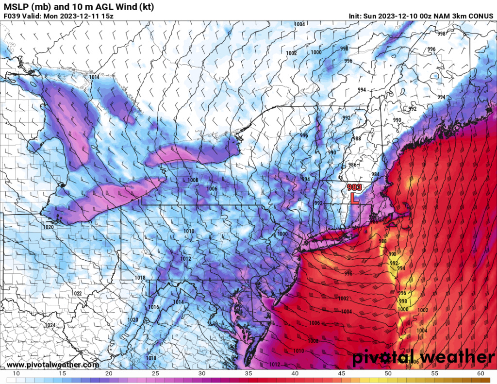
If the NAM holds tru there will be two periods of intensie winds for NYC area but not too far west pretty calm winds. But as the LP pulls out the back side gets back up to 40-50 mph gusts LI looks ugly could see 70mph IMO.

jmanley32- Senior Enthusiast

- Posts : 20535
Reputation : 108
Join date : 2013-12-12
Age : 43
Location : Yonkers, NY
 Re: December 2023 Observations and Discussion
NWS briefing really backed off on the winds west of central LI, has NYC max 35mph, I dunno if I buy it being that low, IMO NYC and southern westchester and eastern NJ should be in a wind advisory at least but as NAM shows the winds are going to be razor sharp cutoff, tough call. Seems heaviest rains now slated to reach 5 inches possibly and the mention isolated lines of t-storms and isolated 60mph gusts in any areas that see that. Will be a interesting night and morning for sure.

jmanley32- Senior Enthusiast

- Posts : 20535
Reputation : 108
Join date : 2013-12-12
Age : 43
Location : Yonkers, NY

jmanley32- Senior Enthusiast

- Posts : 20535
Reputation : 108
Join date : 2013-12-12
Age : 43
Location : Yonkers, NY
 Re: December 2023 Observations and Discussion
Pretty good discussion and popints out what I was saying about the lull in the winds and the razor cutoff, but appears mixing might also be a issue even though 925mb winds are intense.
.SHORT TERM /6 AM SUNDAY MORNING THROUGH MONDAY/...
A 500 mb trough digs in to our west on Sunday, then lifts
during the day Monday with its axis shifting through the
forecast area Monday evening. At the surface, a strong cold
front approaches us on Sunday and passes through during Sunday
night. While it`s passing through, an area of low pressure
develops along the front, passing through or nearby the forecast
area before rapidly deepening to our NE.
Rain chances ramp up through the day with the entire forecast
area likely seeing rain by the end of the afternoon. The rain
could be heavy at times as early as the afternoon as per latest
CAM reflectivity, with this potential lasting into the night.
The heavy rain potential comes from a developing strong low
level jet combining with deep synoptic lift aloft and an
anomalously moist air mass. Some models continue to show some
elevated instability, so with deep lift, will keep in an
isolated thunderstorm in the forecast. Models continue to favor
eastern areas for the higher total rain amounts, as the llj will
be stronger here, and forcing/convergence near the deepening
low center will be passing through or nearby. Further
enhancement may occur in parts of CT due to speed convergence on
a southerly flow. The flood watch has been extended to include
eastern Suffolk County as the trend for heavier rain totals
remains focused more over eastern sections. See the hydrology
section below for more details.
Regarding winds for this event, for several days now, 925mb
winds continue to be progged reach 60-80 kt over roughly the
eastern half of the forecast area Sunday night. Even by late
afternoon, they`re progged at 50-60 kt. There will be a low
level inversion, but not particularly strong. Especially with
the threat of convectively enhanced downpours and models showing
50-60kt winds below the inversion at 1000 ft, there is an
increased threat of seeing wind gusts reaching high wind warning
thresholds in some areas. Thinking about 60-70% of the 925 mb
jet could mix down. Complicating this is that there could be a
couple hours of a lull in the winds as low pressure takes shape
along the developing low nearby or just off to our south. There
could be a pretty sharp east to west gradient where winds could
get to at least wind advisory criteria. There also could be a
timing offset on when the potential convective downpours could
occur with the strongest winds aloft. Therefore do not have the
confidence at this time to upgrade to a high wind warning for
the zones currently under a watch. There is a possibility that
the threat will be more focused over Long Island, and not so
much for Brooklyn and Queens. Will however maintain the watch
for the time being. However, after collaboration with WFO BOX,
have enough confidence to go with a wind advisory along portions
of the CT Coast.
Rain chances continue into Monday even behind the front as the
flow aloft remains cyclonic and we`ll be within the right
entrance region of an upper jet streak. Some cold air wraps in
behind the front, and may cause a mix of rain and snow well NW
of the city in the morning. Little to no snow accumulation
expected. Remaining breezy through the day as we dry out for the
afternoon. Highs generally in the 40s.
Last edited by jmanley32 on Sat Dec 09, 2023 10:31 pm; edited 1 time in total

jmanley32- Senior Enthusiast

- Posts : 20535
Reputation : 108
Join date : 2013-12-12
Age : 43
Location : Yonkers, NY

jmanley32- Senior Enthusiast

- Posts : 20535
Reputation : 108
Join date : 2013-12-12
Age : 43
Location : Yonkers, NY
 Re: December 2023 Observations and Discussion
For the life of me, I just do not see this going the way of the NAM this time. I have figured out that it’s accounting for dynamic cooling in an otherwise extremely marginal airmass. But when I look at the set up, I just don’t see the mechanism by which there’s cold enough air close by enough to be drawn into this system and lifted such that it cools the column below freezing.
For example, when we look at the pattern over the Northern Hemisphere, what do we have?
positive NAO/no 50N/50W low (favors ridging over eastern CONUS)
70N/70E ridge (favors troughing over eastern CONUS)
Neutral AO
negative WPO (favors troughing over eastern CONUS)
positive EPO (favors ridging over eastern CONUS)
neutralizing PNA
MJO phase 4 (favors ridging over eastern CONUS)
neutral SOI
no significant changes in ENSO 1.2 (considered neutral)
warm Gulf (favors ridging over eastern CONUS)
neutral North Atlantic SSTs
So just based on this, there’s no real mechanism to drill cold air/troughing into the eastern CONUS, which makes me think that the northern stream trough will not be able to phase in with the lead wave soon enough for our area to cash in on any substantial totals (i.e. more than 1-3”). I think it’s slower and weaker overall. Similarly, I think this does allow the lead wave to negatively a little sooner, as it’s being nudged to lift out a little quicker by the slight warm bias of the hemispheric factors outlined above. However, this negative tilt doesn’t help us because the secondary northern stream should be less efficient at delivering the fresh shot of colder air into the system. So yeah, we will have great dynamics in play, but they’re all gonna be in a generally “warm” column.
I further support this by bringing up the surface pressure anomalies - the incoming high pressure associated with the incoming northern stream is meager at best, and is being stretched thin between a wave in Canada and our developing coastal storm. So again, low-level cold air transport into the back side of our storm should not be all that efficient. This leads me into a third point that I’d like to make, which is that this incoming front is not sharp when it comes in. What I mean by that is it’s disjointed. The mid-levels are going to cool faster than the lower-levels, which presents a problem. To me, that signifies that the best forcing for ascent is going to outrun the cold advection before the lower levels can cool sufficiently to support accumulating snow. In a classic anafrontal setup, you want to see a very steep frontal system so that the levels almost all change at once, which helps to maximize the overlap between the best synoptic lift and rates of cooling. If we had a mechanism to hammer the northern stream trough and cold air into the eastern CONUS (more favorable Pacific), I’d be all in. But I do not see any mechanism by which we can get enough cold air in the back side in time for our area to really capitalize. As a result, I see the bulk of the precipitation fall as rain, then the cold comes in, and we see it end as a little snow.
Maybe I’m losing my edge, I don’t know. But I can’t get on board with this.
rb924119- Meteorologist

- Posts : 6928
Reputation : 194
Join date : 2013-02-06
Age : 32
Location : Greentown, Pa
 Re: December 2023 Observations and Discussion
Additionally, you have a warm, wet ground to contend with, so a lot of snow will be lost to contact melting. Idk, folks.
rb924119- Meteorologist

- Posts : 6928
Reputation : 194
Join date : 2013-02-06
Age : 32
Location : Greentown, Pa
 Re: December 2023 Observations and Discussion
00z RGEM looks pretty good to me, honestly.
rb924119- Meteorologist

- Posts : 6928
Reputation : 194
Join date : 2013-02-06
Age : 32
Location : Greentown, Pa
 Re: December 2023 Observations and Discussion
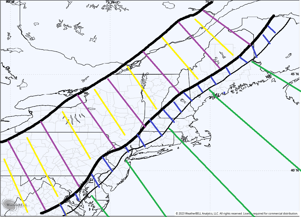
Ray pretty much sums it up, unfort. Below is a very general snow map.
Purple/Yellow = Best chance for accumulation
Blue = may change over and see a few wet flakes; little to no accumulation
Green = Heavy rain
One thing I will add is the winds, esp for eastern half of LI and eastward look real. Have batteries as there likely will be some power outages in Suffolk County especially. NWS has issued a High Wind Warning for Suffolk. To the west may be more isolated.

HIGH WIND WARNING REMAINS IN EFFECT FROM 10 PM THIS EVENING TO
10 AM EST MONDAY...
* WHAT...South winds 25 to 35 mph with gusts up to 60 mph
expected.
* WHERE...Northwest Suffolk, Northeast Suffolk, Southwest
Suffolk and Southeast Suffolk Counties.
* WHEN...From 10 PM this evening to 10 AM EST Monday.
* IMPACTS...Damaging winds will blow down trees and power lines.
Widespread power outages are expected. Travel will be
difficult, especially for high profile vehicles.
For several days now, forecast guidance has been progging 925mb
winds reaching 60-80 kt east of NYC tonight. Even by late afternoon,
they`re progged at 50-60 kt. There will be a low level inversion,
but not particularly strong. Especially with the threat of
convectively enhanced downpours and models showing 50-60kt winds
below the inversion at 1000 ft, there is an increased threat of
seeing wind gusts reaching high wind warning thresholds in some
areas. For now, thinking the place with the best chance to meet high
wind warnings will be across Suffolk county. While portions of
NYC/Nassau County and part of the CT coast, could see an isolated
gusts to warning or come close to it, felt it was best to keep them
in a Wind Advisory. All the forecast guidance is indicating a
fairly sharp cut off with respect to the strongest winds occur. Can
nor rule out the day shift potentially having to adjust the
headlines a bit based on the newer forecast data that comes in
during the day. The combination of a saturated ground and strong
gusty winds, would expect some wind damage across the advisory and
warning locations.
Purple/Yellow = Best chance for accumulation
Blue = may change over and see a few wet flakes; little to no accumulation
Green = Heavy rain

One thing I will add is the winds, esp for eastern half of LI and eastward look real. Have batteries as there likely will be some power outages in Suffolk County especially. NWS has issued a High Wind Warning for Suffolk. To the west may be more isolated.

HIGH WIND WARNING REMAINS IN EFFECT FROM 10 PM THIS EVENING TO
10 AM EST MONDAY...
* WHAT...South winds 25 to 35 mph with gusts up to 60 mph
expected.
* WHERE...Northwest Suffolk, Northeast Suffolk, Southwest
Suffolk and Southeast Suffolk Counties.
* WHEN...From 10 PM this evening to 10 AM EST Monday.
* IMPACTS...Damaging winds will blow down trees and power lines.
Widespread power outages are expected. Travel will be
difficult, especially for high profile vehicles.
For several days now, forecast guidance has been progging 925mb
winds reaching 60-80 kt east of NYC tonight. Even by late afternoon,
they`re progged at 50-60 kt. There will be a low level inversion,
but not particularly strong. Especially with the threat of
convectively enhanced downpours and models showing 50-60kt winds
below the inversion at 1000 ft, there is an increased threat of
seeing wind gusts reaching high wind warning thresholds in some
areas. For now, thinking the place with the best chance to meet high
wind warnings will be across Suffolk county. While portions of
NYC/Nassau County and part of the CT coast, could see an isolated
gusts to warning or come close to it, felt it was best to keep them
in a Wind Advisory. All the forecast guidance is indicating a
fairly sharp cut off with respect to the strongest winds occur. Can
nor rule out the day shift potentially having to adjust the
headlines a bit based on the newer forecast data that comes in
during the day. The combination of a saturated ground and strong
gusty winds, would expect some wind damage across the advisory and
warning locations.
_________________
"In weather and in life, there's no winning and losing; there's only winning and learning."
WINTER 2012/2013 TOTALS 43.65"WINTER 2017/2018 TOTALS 62.85" WINTER 2022/2023 TOTALS 4.9"
WINTER 2013/2014 TOTALS 64.85"WINTER 2018/2019 TOTALS 14.25" WINTER 2023/2024 TOTALS 13.1"
WINTER 2014/2015 TOTALS 71.20"WINTER 2019/2020 TOTALS 6.35"
WINTER 2015/2016 TOTALS 35.00"WINTER 2020/2021 TOTALS 37.75"
WINTER 2016/2017 TOTALS 42.25"WINTER 2021/2022 TOTALS 31.65"

sroc4- Admin

- Posts : 8354
Reputation : 302
Join date : 2013-01-07
Location : Wading River, LI
rb924119 likes this post
 Re: December 2023 Observations and Discussion
42 degrees, cloudy, calm winds.Soaking rainstorm on the way but I see areas N and W of me now in the game for back end snow.Blue and link have expanded in those areas.Figure maybe a slush inch or two here if lucky.

docstox12- Wx Statistician Guru

- Posts : 8530
Reputation : 222
Join date : 2013-01-07
Age : 73
Location : Monroe NY
 Re: December 2023 Observations and Discussion
sroc4 wrote:Ray pretty much sums it up, unfort. Below is a very general snow map.
Purple/Yellow = Best chance for accumulation
Blue = may change over and see a few wet flakes; little to no accumulation
Green = Heavy rain
One thing I will add is the winds, esp for eastern half of LI and eastward look real. Have batteries as there likely will be some power outages in Suffolk County especially. NWS has issued a High Wind Warning for Suffolk. To the west may be more isolated.
HIGH WIND WARNING REMAINS IN EFFECT FROM 10 PM THIS EVENING TO
10 AM EST MONDAY...
* WHAT...South winds 25 to 35 mph with gusts up to 60 mph
expected.
* WHERE...Northwest Suffolk, Northeast Suffolk, Southwest
Suffolk and Southeast Suffolk Counties.
* WHEN...From 10 PM this evening to 10 AM EST Monday.
* IMPACTS...Damaging winds will blow down trees and power lines.
Widespread power outages are expected. Travel will be
difficult, especially for high profile vehicles.
For several days now, forecast guidance has been progging 925mb
winds reaching 60-80 kt east of NYC tonight. Even by late afternoon,
they`re progged at 50-60 kt. There will be a low level inversion,
but not particularly strong. Especially with the threat of
convectively enhanced downpours and models showing 50-60kt winds
below the inversion at 1000 ft, there is an increased threat of
seeing wind gusts reaching high wind warning thresholds in some
areas. For now, thinking the place with the best chance to meet high
wind warnings will be across Suffolk county. While portions of
NYC/Nassau County and part of the CT coast, could see an isolated
gusts to warning or come close to it, felt it was best to keep them
in a Wind Advisory. All the forecast guidance is indicating a
fairly sharp cut off with respect to the strongest winds occur. Can
nor rule out the day shift potentially having to adjust the
headlines a bit based on the newer forecast data that comes in
during the day. The combination of a saturated ground and strong
gusty winds, would expect some wind damage across the advisory and
warning locations.
Agreed. Wide spread Trace amounts north of the Fall Line (you will see flakes in the air)
Scranton area 1-2"
BGH area 4"+
Catskills approach 6"
Highly elevated areas (> 1300') of Poconos and NW NJ 1-2"
Elevated areas of Orange Cty C-1"
This is consolidating too late and moving too fast. The NAM gets inebriated from time to time...
heehaw453- Advanced Forecaster

- Posts : 3906
Reputation : 86
Join date : 2014-01-20
Location : Bedminster Township, PA Elevation 600' ASL
sroc4 and rb924119 like this post
 Re: December 2023 Observations and Discussion
Looks like the NAM is finally caving……or shall I say, sobering up a little lol thank god, because if it continued it might not have been the only one inebriated by the end of the day lmao
Now hopefully there aren’t any last-minute surprises by other guidance or observations haha but if anything, I think forecasts are more likely to bust too high with predicted snowfall rather than too low. Heehaw, for what it’s worth, I think you and Scott combine for a pretty good forecast
Now hopefully there aren’t any last-minute surprises by other guidance or observations haha but if anything, I think forecasts are more likely to bust too high with predicted snowfall rather than too low. Heehaw, for what it’s worth, I think you and Scott combine for a pretty good forecast
rb924119- Meteorologist

- Posts : 6928
Reputation : 194
Join date : 2013-02-06
Age : 32
Location : Greentown, Pa
 Re: December 2023 Observations and Discussion
Okay let's give the NAM some credit here for sniffing out the coastal forming further S and switching areas further east over ro wet flakes. Your GFS and EURO had this storm 3 days ago cutting through C and NNJ and today has it through ELI. 5 days ago it had it through Buffalo. The NAM was over juiced es but it sniffed this out and the GFS was showing some credence to it yesterday.
I agree a wet ground without crashing temps and sleet in a changeover limits the snow accumulations greatly. 3" may fall from the sky but that's not what is sticking.
Soaker of a storm with windy conditions.
Good thing my new roof n gutters were put on last week!!!
I know it's rain but a good sign for when this pattern aligns.
Amazing how this went from a monster cutter to a coastal in 5 days only a 1000 mile shift in location. Imagine the people in Mich who thought they maybe getting a blizzard from this to basically nada.
48* and March like outside.
_________________
Mugs
AKA:King: Snow Weenie
Self Proclaimed
WINTER 2014-15 : 55.12" +.02 for 6 coatings (avg. 35")
WINTER 2015-16 Total - 29.8" (Avg 35")
WINTER 2016-17 : 39.5" so far

amugs- Advanced Forecaster - Mod

- Posts : 15095
Reputation : 213
Join date : 2013-01-07
Age : 54
Location : Hillsdale,NJ
rb924119 likes this post
 Re: December 2023 Observations and Discussion
amugs wrote:Okay let's give the NAM some credit here for sniffing out the coastal forming further S and switching areas further east over ro wet flakes. Your GFS and EURO had this storm 3 days ago cutting through C and NNJ and today has it through ELI. 5 days ago it had it through Buffalo. The NAM was over juiced es but it sniffed this out and the GFS was showing some credence to it yesterday.
I agree a wet ground without crashing temps and sleet in a changeover limits the snow accumulations greatly. 3" may fall from the sky but that's not what is sticking.
Soaker of a storm with windy conditions.
Good thing my new roof n gutters were put on last week!!!
I know it's rain but a good sign for when this pattern aligns.
Amazing how this went from a monster cutter to a coastal in 5 days only a 1000 mile shift in location. Imagine the people in Mich who thought they maybe getting a blizzard from this to basically nada.
48* and March like outside.
Hey, if you really want to play this game, go back about two weeks in the LR thread and see my post about the possibility of a snow event during the 5th-9th period
All kidding aside, the NAM can be a dangerous model, especially with coastals/Miller-A events. In fact, I always take it into account when I make a forecast because I have found it to be quite useful, significantly more so than the “upgraded” GFS (don’t even get me started on that model. It should be renamed the GooFuS model as far as I’m concerned. Even the GEM has an higher skill score now. Mods, is there a way we can get that corrected in the forum? lol Anyway….) And when I saw it the other day I immediately gave it attention, and I do believe heehaw was the first to post in detail about this potential a couple days ago. So it was being given respect. I can’t say this definitively yet since the event has yet to unfold, but I think it just went too far this time, which is why we/I are/am having a little fun with it. When the 12z EURO came out yesterday and we had the NAM/EURO in the same camp, I really thought it might have been game on, but again, I don’t think the pattern supports that type of outcome, and the backing away of models makes sense, in my opinion.
rb924119- Meteorologist

- Posts : 6928
Reputation : 194
Join date : 2013-02-06
Age : 32
Location : Greentown, Pa
amugs likes this post
 Re: December 2023 Observations and Discussion
amugs wrote:Okay let's give the NAM some credit here for sniffing out the coastal forming further S and switching areas further east over ro wet flakes. Your GFS and EURO had this storm 3 days ago cutting through C and NNJ and today has it through ELI. 5 days ago it had it through Buffalo. The NAM was over juiced es but it sniffed this out and the GFS was showing some credence to it yesterday.
I agree a wet ground without crashing temps and sleet in a changeover limits the snow accumulations greatly. 3" may fall from the sky but that's not what is sticking.
Soaker of a storm with windy conditions.
Good thing my new roof n gutters were put on last week!!!
I know it's rain but a good sign for when this pattern aligns.
Amazing how this went from a monster cutter to a coastal in 5 days only a 1000 mile shift in location. Imagine the people in Mich who thought they maybe getting a blizzard from this to basically nada.
48* and March like outside.
For the record the first time the NAM came into range(00zz Dec 8th) with this system it was waaaay west. It wasnt until Dec 9th 00z that it came in line with the Euro and GFS.


Euro 00z Dec 8th had this:


_________________
"In weather and in life, there's no winning and losing; there's only winning and learning."
WINTER 2012/2013 TOTALS 43.65"WINTER 2017/2018 TOTALS 62.85" WINTER 2022/2023 TOTALS 4.9"
WINTER 2013/2014 TOTALS 64.85"WINTER 2018/2019 TOTALS 14.25" WINTER 2023/2024 TOTALS 13.1"
WINTER 2014/2015 TOTALS 71.20"WINTER 2019/2020 TOTALS 6.35"
WINTER 2015/2016 TOTALS 35.00"WINTER 2020/2021 TOTALS 37.75"
WINTER 2016/2017 TOTALS 42.25"WINTER 2021/2022 TOTALS 31.65"

sroc4- Admin

- Posts : 8354
Reputation : 302
Join date : 2013-01-07
Location : Wading River, LI
 Re: December 2023 Observations and Discussion
60* and we had our first bout of heavy rain..was going to go out and mosey around..but nope sitting with the pups...going to pull out a book  instead..

weatherwatchermom- Senior Enthusiast

- Posts : 3793
Reputation : 78
Join date : 2014-11-25
Location : Hazlet Township, NJ
Dunnzoo likes this post
 Re: December 2023 Observations and Discussion
51 at 1:45 pm. Barely any rain but looks like it will. Still no wind

dkodgis- Senior Enthusiast

- Posts : 2560
Reputation : 98
Join date : 2013-12-29
 Re: December 2023 Observations and Discussion
Heavy rain again no wind yet
frank 638- Senior Enthusiast

- Posts : 2843
Reputation : 37
Join date : 2016-01-01
Age : 40
Location : bronx ny
 Re: December 2023 Observations and Discussion
57* here and absolutely pouring. 0.36in so far. Current rain rate 2.06in/hr
_________________
-Alex Iannone-

aiannone- Senior Enthusiast - Mod

- Posts : 4815
Reputation : 92
Join date : 2013-01-07
Location : Saint James, LI (Northwest Suffolk Co.)
 Re: December 2023 Observations and Discussion
a little over an inch since it started around 12...still coming down steady with intervals of heavier rain. long lazy day.

weatherwatchermom- Senior Enthusiast

- Posts : 3793
Reputation : 78
Join date : 2014-11-25
Location : Hazlet Township, NJ
 Re: December 2023 Observations and Discussion
53*, rain for the last few hours, but not really much, about quarter of an inch so far. Just ick.
_________________
Janet
Snowfall winter of 2023-2024 17.5"
Snowfall winter of 2022-2023 6.0"
Snowfall winter of 2021-2022 17.6" 1" sleet 2/25/22
Snowfall winter of 2020-2021 51.1"
Snowfall winter of 2019-2020 8.5"
Snowfall winter of 2018-2019 25.1"
Snowfall winter of 2017-2018 51.9"
Snowfall winter of 2016-2017 45.6"
Snowfall winter of 2015-2016 29.5"
Snowfall winter of 2014-2015 50.55"
Snowfall winter of 2013-2014 66.5"
Dunnzoo- Senior Enthusiast - Mod

- Posts : 4905
Reputation : 68
Join date : 2013-01-11
Age : 62
Location : Westwood, NJ

aiannone- Senior Enthusiast - Mod

- Posts : 4815
Reputation : 92
Join date : 2013-01-07
Location : Saint James, LI (Northwest Suffolk Co.)
Dunnzoo likes this post
Page 5 of 11 •  1, 2, 3, 4, 5, 6 ... 9, 10, 11
Page 5 of 11
Permissions in this forum:
You cannot reply to topics in this forum|
|
|

 Home
Home