
 Search
BLOG: March 12th-13th Potential Snowstorm, Discussion Thread 1.0
Page 6 of 12 •  1, 2, 3 ... 5, 6, 7 ... 10, 11, 12
 ![]()
Re: BLOG: March 12th-13th Potential Snowstorm, Discussion Thread 1.0
![]() by amugs Sun Mar 09, 2014 2:03 pm
by amugs Sun Mar 09, 2014 2:03 pm

The battle !!!! I will always side with Snowy in winter and late fall!
Heat Miser you can your day in mid-late spring and summer let us have these last days you $#@&!!
amugs- Advanced Forecaster - Mod

- Posts : 15093
Join date : 2013-01-07
Re: BLOG: March 12th-13th Potential Snowstorm, Discussion Thread 1.0
![]() by jimv45 Sun Mar 09, 2014 2:09 pm
by jimv45 Sun Mar 09, 2014 2:09 pm
jimv45- Senior Enthusiast

- Posts : 1168
Join date : 2013-09-20
Re: BLOG: March 12th-13th Potential Snowstorm, Discussion Thread 1.0
![]() by SNOW MAN Sun Mar 09, 2014 2:43 pm
by SNOW MAN Sun Mar 09, 2014 2:43 pm

SNOW MAN- Senior Enthusiast
- Posts : 1361
Reputation : 25
Join date : 2013-01-13
Age : 64
Location : Marshalls Creek Pa.
Re: BLOG: March 12th-13th Potential Snowstorm, Discussion Thread 1.0
![]() by SoulSingMG Sun Mar 09, 2014 2:52 pm
by SoulSingMG Sun Mar 09, 2014 2:52 pm

SoulSingMG- Senior Enthusiast
- Posts : 2853
Reputation : 74
Join date : 2013-12-11
Location : Long Island City, NY
Re: BLOG: March 12th-13th Potential Snowstorm, Discussion Thread 1.0
![]() by SNOW MAN Sun Mar 09, 2014 2:56 pm
by SNOW MAN Sun Mar 09, 2014 2:56 pm
SNOW MAN- Senior Enthusiast
- Posts : 1361
Reputation : 25
Join date : 2013-01-13
Age : 64
Location : Marshalls Creek Pa.
Re: BLOG: March 12th-13th Potential Snowstorm, Discussion Thread 1.0
![]() by pdubz Sun Mar 09, 2014 3:10 pm
by pdubz Sun Mar 09, 2014 3:10 pm

pdubz- Pro Enthusiast

- Posts : 539
Reputation : 0
Join date : 2013-09-24
Age : 32
Location : Port Washington,NY (L.I)
Re: BLOG: March 12th-13th Potential Snowstorm, Discussion Thread 1.0
![]() by Frank_Wx Sun Mar 09, 2014 3:15 pm
by Frank_Wx Sun Mar 09, 2014 3:15 pm
_________________
_______________________________________________________________________________________________________
CLICK HERE to view NJ Strong Snowstorm Classifications

Frank_Wx- Godzilla Seeker

- Posts : 21305
Reputation : 328
Join date : 2013-01-05
Age : 31
Location : Jersey City, NJ -

Re: BLOG: March 12th-13th Potential Snowstorm, Discussion Thread 1.0
![]() by Frank_Wx Sun Mar 09, 2014 3:38 pm
by Frank_Wx Sun Mar 09, 2014 3:38 pm

The east-based blocking is a little too far east for us and as a result the PV stays further north. Maybe over the next couple days we see the PV trending southward again which will track the storm further south as well. This was the case with the last storm, except we missed out completely. If the PV turns out to be further south than modeled this time around, we would benefit.
_________________
_______________________________________________________________________________________________________
CLICK HERE to view NJ Strong Snowstorm Classifications
Frank_Wx- Godzilla Seeker
- Posts : 21305
Reputation : 328
Join date : 2013-01-05
Age : 31
Location : Jersey City, NJ -
Re: BLOG: March 12th-13th Potential Snowstorm, Discussion Thread 1.0
![]() by algae888 Sun Mar 09, 2014 4:55 pm
by algae888 Sun Mar 09, 2014 4:55 pm

algae888- Advanced Forecaster

- Posts : 5311
Reputation : 46
Join date : 2013-02-05
Age : 61
Location : mt. vernon, new york
Re: BLOG: March 12th-13th Potential Snowstorm, Discussion Thread 1.0
![]() by pdubz Sun Mar 09, 2014 5:04 pm
by pdubz Sun Mar 09, 2014 5:04 pm
pdubz- Pro Enthusiast
- Posts : 539
Reputation : 0
Join date : 2013-09-24
Age : 32
Location : Port Washington,NY (L.I)
Re: BLOG: March 12th-13th Potential Snowstorm, Discussion Thread 1.0
![]() by sroc4 Sun Mar 09, 2014 5:05 pm
by sroc4 Sun Mar 09, 2014 5:05 pm
 " />
" />The timing of the system on the CMC and GFS are very similar, whereas, the Euro is about 6-8hrs slower. Here is 00z Thursday for all three models (GFS, CMC, Euro).
 " />
" /> " />
" />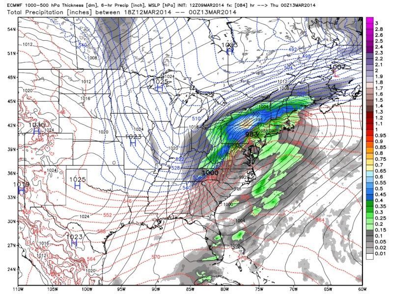 " />
" />They all are warm at the start and usher in cold behind it. Rain to snow. For the moment I am not very excited for much of a change over to snow at all for I-95 and points S and east along the coast and LI before the heaviest precip moves out. Interior sections north and west of I 95 have a chance here to see decent accumulating snow as is modeled by todays runs however.
All this being said there is still a looooooong way to go. I am by no means ruling out accum snow all the way to the coast at this point..just seems unlikely based on whats currently modeled. The GFS and CMC ensemble means today are south of their operational runs. The Euro Ensembles look to be about on par with its operational. Lets see if the tracks above shift further N or S or stay about the same by Tuesday morning. You will not see a snow amount from this guy until no earlier than after Monday eve 00z runs...so Tues. morn. I've learned my lesson.
 " />
" /> " />
" /> " />
" />_________________
"In weather and in life, there's no winning and losing; there's only winning and learning."
WINTER 2012/2013 TOTALS 43.65"WINTER 2017/2018 TOTALS 62.85" WINTER 2022/2023 TOTALS 4.9"
WINTER 2013/2014 TOTALS 64.85"WINTER 2018/2019 TOTALS 14.25" WINTER 2023/2024 TOTALS 13.1"
WINTER 2014/2015 TOTALS 71.20"WINTER 2019/2020 TOTALS 6.35"
WINTER 2015/2016 TOTALS 35.00"WINTER 2020/2021 TOTALS 37.75"
WINTER 2016/2017 TOTALS 42.25"WINTER 2021/2022 TOTALS 31.65"

sroc4- Admin
- Posts : 8331
Reputation : 301
Join date : 2013-01-07
Location : Wading River, LI
Re: BLOG: March 12th-13th Potential Snowstorm, Discussion Thread 1.0
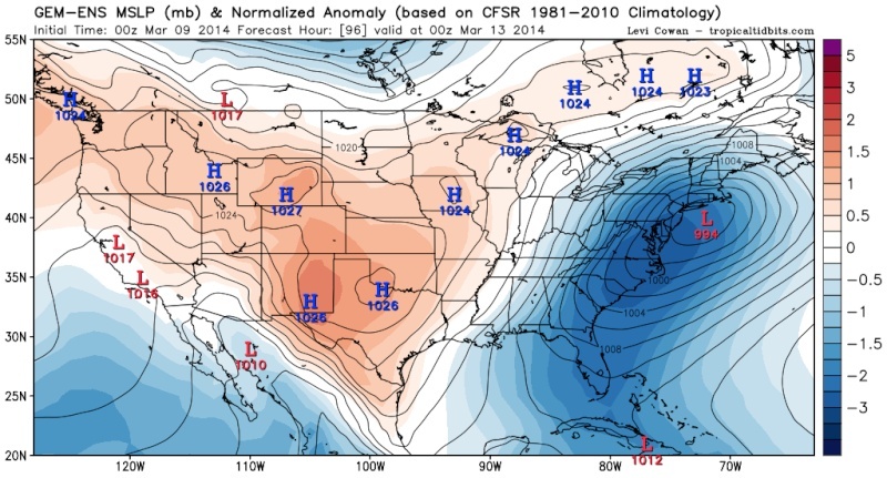
![]() by algae888 Sun Mar 09, 2014 5:37 pm
by algae888 Sun Mar 09, 2014 5:37 pm
MODELS ARE IN GOOD AGREEMENT WITH THE H5 FLOW THROUGH TUE...BUT
CONTINUE TO HAVE ISSUES WITH PAC NW ENERGY MOVING ONSHORE AND
PHASING WITH THE SOUTHERN BRANCH OF THE JET STREAM BY MIDWEEK. WHILE
CONFIDENCE IS INCREASING THAT WE WILL BE IMPACTED BY THIS
SYSTEM...THE DETAILS REMAIN IN QUESTION.
SUNYSB ENSEMBLE SENSITIVITY ANALYSIS INDICATES THAT
THE UNCERTAINTY LIES WITH THIS PAC ENERGY THAT WILL MOVE ONSHORE
EARLY MON MORNING. A DEEPER SOLN WOULD LEND TO MORE RIDGING
DOWNSTREAM AND ULTIMATELY RESULT IN A TRACK CLOSER TO THE COAST.
THESE DIFFERENCES COULD LEAD TO SIGNIFICANT CHANGES IN THE
FORECAST AS A SOLN FURTHER OFFSHORE WOULD LIKELY BE COLDER.
HOPING THAT ONCE THE PAC ENERGY MOVES ONSHORE TOMORROW WHERE THERE
IS BETTER DATA SAMPLING...SOLNS WILL CONVERGE FURTHER AND
CONFIDENCE WILL INCREASE.
we should have better idea of track after tom 12z runs
algae888- Advanced Forecaster
- Posts : 5311
Reputation : 46
Join date : 2013-02-05
Age : 61
Location : mt. vernon, new york
Re: BLOG: March 12th-13th Potential Snowstorm, Discussion Thread 1.0
![]() by algae888 Sun Mar 09, 2014 5:41 pm
by algae888 Sun Mar 09, 2014 5:41 pm
pdubz wrote:Really? NAM snowmap shows it further north
we shouldn't look at snow map. we need to look at intensity and track. if the 18z nam were to verify there would be more snow due to dynamic cooling. models don't pick up on this well enough.
algae888- Advanced Forecaster
- Posts : 5311
Reputation : 46
Join date : 2013-02-05
Age : 61
Location : mt. vernon, new york
Re: BLOG: March 12th-13th Potential Snowstorm, Discussion Thread 1.0
![]() by jmanley32 Sun Mar 09, 2014 5:51 pm
by jmanley32 Sun Mar 09, 2014 5:51 pm

jmanley32- Senior Enthusiast
- Posts : 20513
Reputation : 108
Join date : 2013-12-12
Age : 42
Location : Yonkers, NY
Re: BLOG: March 12th-13th Potential Snowstorm, Discussion Thread 1.0
![]() by jmanley32 Sun Mar 09, 2014 7:54 pm
by jmanley32 Sun Mar 09, 2014 7:54 pm
jmanley32- Senior Enthusiast
- Posts : 20513
Reputation : 108
Join date : 2013-12-12
Age : 42
Location : Yonkers, NY
Re: BLOG: March 12th-13th Potential Snowstorm, Discussion Thread 1.0
![]() by amugs Sun Mar 09, 2014 8:18 pm
by amugs Sun Mar 09, 2014 8:18 pm
jmanley32 wrote:Is there any possibility with such a strong low being forecast that snow could be at the coast for most or all of the event or is this totally off the table? Funny thing is (and I know this is for long range forum) my local forecast has more confidence in all snow for 18th than this storm, at 70% already!
Jman - 18th is too far out. They had this event as all snow last week as well.
Here is the forecasted thermal profile - temps - jesus is this going to be tight
N&W from this will be very interesting if is comes to fruition - tomorrow we will know a hell of a lot more - the usual 60-48 hours before the storm - the pattern of the winter so most options are on the table IMO but trending S
http://tinypic.com/view.php?pic=286v95k&s=8
Last edited by amugs on Sun Mar 09, 2014 10:02 pm; edited 1 time in total
_________________
Mugs
AKA:King: Snow Weenie
Self Proclaimed
WINTER 2014-15 : 55.12" +.02 for 6 coatings (avg. 35")
WINTER 2015-16 Total - 29.8" (Avg 35")
WINTER 2016-17 : 39.5" so far

amugs- Advanced Forecaster - Mod
- Posts : 15093
Reputation : 213
Join date : 2013-01-07
Age : 54
Location : Hillsdale,NJ
Re: BLOG: March 12th-13th Potential Snowstorm, Discussion Thread 1.0
![]() by sroc4 Sun Mar 09, 2014 9:04 pm
by sroc4 Sun Mar 09, 2014 9:04 pm
All snow at the coast is unlikely at the moment, but is def not off the table. JMan. If you go back a few posts you can see where the approx tracks have trended to thus far. If that's the track this sucker takes it will be mostly rain for the coast. Keep in mind that is not set in stone. The timing and intensity of the phase is still not set in stone. Heck If the western ridge trends more amped and the northern stream digs in just a little further south the triple phase soln still could happen. The Euro is not all that far off from the third piece of southern energy interacting with the other two. At the moment I think the triple phase is least likely to happen but still possible. Bottom line is as of now this storm is modeled to come in like the map I drew above, but significant trends are still possible as the energy will just be making it ashore tomorrow morning. Look for changes to the track by the 12z and 00z tomorrow if they are going to occur since much better data will be plugged into the models.jmanley32 wrote:Is there any possibility with such a strong low being forecast that snow could be at the coast for most or all of the event or is this totally off the table? Funny thing is (and I know this is for long range forum) my local forecast has more confidence in all snow for 18th than this storm, at 70% already!
_________________
"In weather and in life, there's no winning and losing; there's only winning and learning."
WINTER 2012/2013 TOTALS 43.65"WINTER 2017/2018 TOTALS 62.85" WINTER 2022/2023 TOTALS 4.9"
WINTER 2013/2014 TOTALS 64.85"WINTER 2018/2019 TOTALS 14.25" WINTER 2023/2024 TOTALS 13.1"
WINTER 2014/2015 TOTALS 71.20"WINTER 2019/2020 TOTALS 6.35"
WINTER 2015/2016 TOTALS 35.00"WINTER 2020/2021 TOTALS 37.75"
WINTER 2016/2017 TOTALS 42.25"WINTER 2021/2022 TOTALS 31.65"
sroc4- Admin
- Posts : 8331
Reputation : 301
Join date : 2013-01-07
Location : Wading River, LI
Re: BLOG: March 12th-13th Potential Snowstorm, Discussion Thread 1.0
![]() by jmanley32 Sun Mar 09, 2014 9:13 pm
by jmanley32 Sun Mar 09, 2014 9:13 pm
jmanley32- Senior Enthusiast
- Posts : 20513
Reputation : 108
Join date : 2013-12-12
Age : 42
Location : Yonkers, NY
Re: BLOG: March 12th-13th Potential Snowstorm, Discussion Thread 1.0
![]() by NjWeatherGuy Sun Mar 09, 2014 9:23 pm
by NjWeatherGuy Sun Mar 09, 2014 9:23 pm

NjWeatherGuy- Advanced Forecaster
- Posts : 4100
Reputation : 28
Join date : 2013-01-06
Location : Belle Mead, NJ
Re: BLOG: March 12th-13th Potential Snowstorm, Discussion Thread 1.0
![]() by Frank_Wx Sun Mar 09, 2014 10:38 pm
by Frank_Wx Sun Mar 09, 2014 10:38 pm
_________________
_______________________________________________________________________________________________________
CLICK HERE to view NJ Strong Snowstorm Classifications
Frank_Wx- Godzilla Seeker
- Posts : 21305
Reputation : 328
Join date : 2013-01-05
Age : 31
Location : Jersey City, NJ -
Re: BLOG: March 12th-13th Potential Snowstorm, Discussion Thread 1.0
![]() by jmanley32 Sun Mar 09, 2014 10:42 pm
by jmanley32 Sun Mar 09, 2014 10:42 pm
jmanley32- Senior Enthusiast
- Posts : 20513
Reputation : 108
Join date : 2013-12-12
Age : 42
Location : Yonkers, NY
Re: BLOG: March 12th-13th Potential Snowstorm, Discussion Thread 1.0
![]() by algae888 Sun Mar 09, 2014 11:00 pm
by algae888 Sun Mar 09, 2014 11:00 pm
Frank_Wx wrote:NAM is much further south and colder. Is this a trend?
yes nice run. I do not have snow map but hv does real well on this run. it looks like slower west to east progression of storm and the ns s/w is stronger and the phase happens later causing colder air to filter in. it looks to move due east from wv to Delmarva and then ne. I think we want the storm to slow a little more to allow colder air to filter in.
algae888- Advanced Forecaster
- Posts : 5311
Reputation : 46
Join date : 2013-02-05
Age : 61
Location : mt. vernon, new york
Re: BLOG: March 12th-13th Potential Snowstorm, Discussion Thread 1.0
![]() by algae888 Sun Mar 09, 2014 11:19 pm
by algae888 Sun Mar 09, 2014 11:19 pm
algae888- Advanced Forecaster
- Posts : 5311
Reputation : 46
Join date : 2013-02-05
Age : 61
Location : mt. vernon, new york
Re: BLOG: March 12th-13th Potential Snowstorm, Discussion Thread 1.0
![]() by jmanley32 Sun Mar 09, 2014 11:52 pm
by jmanley32 Sun Mar 09, 2014 11:52 pm
jmanley32- Senior Enthusiast
- Posts : 20513
Reputation : 108
Join date : 2013-12-12
Age : 42
Location : Yonkers, NY
Re: BLOG: March 12th-13th Potential Snowstorm, Discussion Thread 1.0
![]() by jmanley32 Sun Mar 09, 2014 11:54 pm
by jmanley32 Sun Mar 09, 2014 11:54 pm
jmanley32- Senior Enthusiast
- Posts : 20513
Reputation : 108
Join date : 2013-12-12
Age : 42
Location : Yonkers, NY
Re: BLOG: March 12th-13th Potential Snowstorm, Discussion Thread 1.0
![]() by Frank_Wx Mon Mar 10, 2014 12:00 am
by Frank_Wx Mon Mar 10, 2014 12:00 am
_________________
_______________________________________________________________________________________________________
CLICK HERE to view NJ Strong Snowstorm Classifications
Frank_Wx- Godzilla Seeker
- Posts : 21305
Reputation : 328
Join date : 2013-01-05
Age : 31
Location : Jersey City, NJ -
Re: BLOG: March 12th-13th Potential Snowstorm, Discussion Thread 1.0
![]() by Frank_Wx Mon Mar 10, 2014 12:00 am
by Frank_Wx Mon Mar 10, 2014 12:00 am
jmanley32 wrote:00z came out late for some reason but its also a hair south, praying this is a trend and will go even more tomorrow when this thing comes on shore. We were tricked last time maybe its doing the opposite trick this time in our favor : )
It is the time change. Lol.
_________________
_______________________________________________________________________________________________________
CLICK HERE to view NJ Strong Snowstorm Classifications
Frank_Wx- Godzilla Seeker
- Posts : 21305
Reputation : 328
Join date : 2013-01-05
Age : 31
Location : Jersey City, NJ -
Sponsored content
Page 6 of 12 • 1, 2, 3 ... 5, 6, 7 ... 10, 11, 12 ![]()
|
|
|