
 Search
Long Range Thread 9.0
Page 8 of 40 •  1 ... 5 ... 7, 8, 9 ... 24 ... 40
 ![]()
Re: Long Range Thread 9.0
![]() by Frank_Wx Sun Nov 29, 2015 11:23 am
by Frank_Wx Sun Nov 29, 2015 11:23 am
docstox12 wrote:Would this strongly negative SOI indicate the El Nino will be peaking and then receding in December?
Ahh yes, the million dollar question. When will El Nino peak? If you look back at other Nino years and their SOI, you'll notice it's difficult to find any correlation because the SOI fluctuates so much.
http://www.bom.gov.au/climate/current/soihtm1.shtml
Therefore, I think the SOI is a poor indicator to use to determine if Nino peaked or not. I think ONI, a measure of SSTs in each Nino region, is better to use. I'm still waiting for this week's update, but as of last week Nino region 3.4 was still warming. Now up to +3.1*C. You can follow ONIs here.
http://www.cpc.ncep.noaa.gov/data/indices/wksst8110.for
Frank_Wx- Godzilla Seeker

- Posts : 21305
Join date : 2013-01-05 -

Re: Long Range Thread 9.0
![]() by docstox12 Sun Nov 29, 2015 11:31 am
by docstox12 Sun Nov 29, 2015 11:31 am
docstox12- Wx Statistician Guru

- Posts : 8504
Join date : 2013-01-07
Re: Long Range Thread 9.0
![]() by Frank_Wx Sun Nov 29, 2015 11:34 am
by Frank_Wx Sun Nov 29, 2015 11:34 am
docstox12 wrote:OK, Frank, thanks for that SOI discussion.Will watch the ONI instead for a clearer Nino picture.
Yea and there's also real and current observations you can use such as SSTA changes over last 7 days, 850mb zonal winds over the Tropical Pacific, 200mb winds, etc.
The direction in which they're blowing, westerly or easterly, is a good indication of where El Nino is trending relative to strength.
_________________
_______________________________________________________________________________________________________
CLICK HERE to view NJ Strong Snowstorm Classifications

Frank_Wx- Godzilla Seeker
- Posts : 21305
Reputation : 328
Join date : 2013-01-05
Age : 31
Location : Jersey City, NJ -
Re: Long Range Thread 9.0
![]() by sroc4 Sun Nov 29, 2015 11:48 am
by sroc4 Sun Nov 29, 2015 11:48 am
Frank_Wx wrote:This response applies both to Scott and Doc. In my opinion, the drop of the SOI is more of an indication of our pattern heading into what typically resembles a strong El Nino during December. The pattern over the month of November resembled more of a La Niña if anything. During Nov the SOI, for the most part, was neutral and the MJO was very active. That is completely opposite of El Nino regimes, which should keep the SOI steadily negative and the MJO inactive (in the circle of death). Now we're seeing the SOI tank and the MJO head into the COD. Plus, LR guidance is accurately showing the AK Vortex and Canadian ridge.
Further, prior El Nino years like 83 and 97 experienced similar SOI drops and those two years had pretty different outcomes to their winter. In sum, I think the SOI drop is a response to our pattern headed to an El Nino configuration and NOT an indication we're seeing a pattern change to colder weather in the near future.
Like I mentioned, this pattern change will occur once the Stratosphere cooperates. The 2002-2003 correlation is interesting but I'm not buying it until other variables fall into place.
This may be true Frank but if you are going to discuss 97 and 83 you must point out the SST conf was drastically different; therefore, a much diff response to the SOI. Correct me if Im wrong but when you get a strong fluctuations to the SOI relative to the base state, in this case a crash, you end up with changes to the relative strength of the westerlies/easterlies. Like you noted this November the pattern was more typical of a Nino pattern despite the daily SOI values avging in a "neutral state". If you look the 30 day avg SOI as of October 31st it was -21.01. In less than one month the 30 day avg SOI went from -21.01 to -2.99. Noted in my prev post this is an unprecedented rise in an el nino year for the month of November. The behavior of the atmosphere being completely opposite of El Nino regimes I believe is more because of this unprecedented rise in the SOI relative to where it was back in OCT and enhanced Easterlies as a result. Enhanced easterlies and warm Indian Ocean SSTA has led to an enhanced MJO in the 2/3 phases for the better part of Nov. Now taking consideration of the current SST anomalies this year relative to say 97,( ie: much stronger SSTA in the Eastern NINO regions in 97 vs much stronger in the central Nino regions this year as well as the relationship with the Northern Pac SSTA alignment) I think this SOI drop might actually enhance the possibility for a trough in the east 2-3weeks from now for the following reasons.
 " />
" />Again correct me if I am wrong here, but the SOI crash is an indicator that the relative pressures are increasing over Darwin Australia, and dropping over Tahiti. The result of this would lead to a westerly wind burst as air tends to move from High pressure to low pressure. Now because of the SSTA alignment this burst in theory would lead to the westerly wind burst meeting the easterlies and enhanced tropical forcing further west towards the dateline and an enhancement to the Ak vortex further west near south of the Aleutians vs say 97 where the SSTA alignment led to the tropical forcing being much further east enhancing the trough set up over the west coast. At least in theory. I could be totally off base here.
_________________
"In weather and in life, there's no winning and losing; there's only winning and learning."
WINTER 2012/2013 TOTALS 43.65"WINTER 2017/2018 TOTALS 62.85" WINTER 2022/2023 TOTALS 4.9"
WINTER 2013/2014 TOTALS 64.85"WINTER 2018/2019 TOTALS 14.25" WINTER 2023/2024 TOTALS 13.1"
WINTER 2014/2015 TOTALS 71.20"WINTER 2019/2020 TOTALS 6.35"
WINTER 2015/2016 TOTALS 35.00"WINTER 2020/2021 TOTALS 37.75"
WINTER 2016/2017 TOTALS 42.25"WINTER 2021/2022 TOTALS 31.65"

sroc4- Admin
- Posts : 8331
Reputation : 301
Join date : 2013-01-07
Location : Wading River, LI
Re: Long Range Thread 9.0
![]() by algae888 Sun Nov 29, 2015 4:52 pm
by algae888 Sun Nov 29, 2015 4:52 pm

new mjo forecast. what can I say. murphy's law! strato, AO, NAO MJO, el-nino. what a mountain to climb!!!!

algae888- Advanced Forecaster

- Posts : 5311
Reputation : 46
Join date : 2013-02-05
Age : 61
Location : mt. vernon, new york
Re: Long Range Thread 9.0
![]() by amugs Sun Nov 29, 2015 6:55 pm
by amugs Sun Nov 29, 2015 6:55 pm
UGLY +EPO and -PNA Euro Weeklies

This looks a lot better by my little eye in the game of eye spy -EPO and +PNA but it looks to be transient.

JB just put out a winter update and is staying the course with his winter prediction.
"Overall this forecast remains the same. Winter is going to be a challenge. I don't believe in broad-brushing El Niños to a standard one size fits all composite. Our blend of analogs, even with warm winters factored in, gives a major cold and snowy winter over the South and into the East. This will be a back-weighted winter. While there is a chance the warmer ideas win out, the current idea is for a colder December than November overall (opposite of last year) followed perhaps by a pullback, and then the core of the winter will be from mid-January on, which was first said back in August.
.gif)
This is what we want to see and it is staying the course - just have to chin and bear it here !!

I know there will be many who will be again cancelling winter but peeps it is strong El Nino that is driving the pattern right now which is fine cause when that stupid AK Vortex drops SW of the Aleutians due to trop forcing/convection out by 155W and the Dateline we WILL be dancing.
DEC 14-17 is a good chance for snow for the LHV and NWNJ - going by Jiom Witt's calendar and the planetary alignment.
Spent 5.5 hrs in the car on the ride home from DC - never doing that again on Turkey weekend!!
_________________
Mugs
AKA:King: Snow Weenie
Self Proclaimed
WINTER 2014-15 : 55.12" +.02 for 6 coatings (avg. 35")
WINTER 2015-16 Total - 29.8" (Avg 35")
WINTER 2016-17 : 39.5" so far

amugs- Advanced Forecaster - Mod

- Posts : 15093
Reputation : 213
Join date : 2013-01-07
Age : 54
Location : Hillsdale,NJ
Re: Long Range Thread 9.0
![]() by Frank_Wx Sun Nov 29, 2015 7:14 pm
by Frank_Wx Sun Nov 29, 2015 7:14 pm
sroc4 wrote:Frank_Wx wrote:This response applies both to Scott and Doc. In my opinion, the drop of the SOI is more of an indication of our pattern heading into what typically resembles a strong El Nino during December. The pattern over the month of November resembled more of a La Niña if anything. During Nov the SOI, for the most part, was neutral and the MJO was very active. That is completely opposite of El Nino regimes, which should keep the SOI steadily negative and the MJO inactive (in the circle of death). Now we're seeing the SOI tank and the MJO head into the COD. Plus, LR guidance is accurately showing the AK Vortex and Canadian ridge.
Further, prior El Nino years like 83 and 97 experienced similar SOI drops and those two years had pretty different outcomes to their winter. In sum, I think the SOI drop is a response to our pattern headed to an El Nino configuration and NOT an indication we're seeing a pattern change to colder weather in the near future.
Like I mentioned, this pattern change will occur once the Stratosphere cooperates. The 2002-2003 correlation is interesting but I'm not buying it until other variables fall into place.
This may be true Frank but if you are going to discuss 97 and 83 you must point out the SST conf was drastically different; therefore, a much diff response to the SOI. Correct me if Im wrong but when you get a strong fluctuations to the SOI relative to the base state, in this case a crash, you end up with changes to the relative strength of the westerlies/easterlies. Like you noted this November the pattern was more typical of a Nino pattern despite the daily SOI values avging in a "neutral state". If you look the 30 day avg SOI as of October 31st it was -21.01. In less than one month the 30 day avg SOI went from -21.01 to -2.99. Noted in my prev post this is an unprecedented rise in an el nino year for the month of November. The behavior of the atmosphere being completely opposite of El Nino regimes I believe is more because of this unprecedented rise in the SOI relative to where it was back in OCT and enhanced Easterlies as a result. Enhanced easterlies and warm Indian Ocean SSTA has led to an enhanced MJO in the 2/3 phases for the better part of Nov. Now taking consideration of the current SST anomalies this year relative to say 97,( ie: much stronger SSTA in the Eastern NINO regions in 97 vs much stronger in the central Nino regions this year as well as the relationship with the Northern Pac SSTA alignment) I think this SOI drop might actually enhance the possibility for a trough in the east 2-3weeks from now for the following reasons.
Again correct me if I am wrong here, but the SOI crash is an indicator that the relative pressures are increasing over Darwin Australia, and dropping over Tahiti. The result of this would lead to a westerly wind burst as air tends to move from High pressure to low pressure. Now because of the SSTA alignment this burst in theory would lead to the westerly wind burst meeting the easterlies and enhanced tropical forcing further west towards the dateline and an enhancement to the Ak vortex further west near south of the Aleutians vs say 97 where the SSTA alignment led to the tropical forcing being much further east enhancing the trough set up over the west coast. At least in theory. I could be totally off base here.
The relationship between the SOI and westerly / easterly winds I may need to study more of. I understand how SOI is calculated - difference in pressures between Tahiti and Darwin - and realize -8 or lower points to El Nino conditions and +8 or greater signals La Nina. Let's take November 2015 for example. As you stated, there were strong easterly winds in the eastern Nino regions. This is 100% correct according to the graphs below.

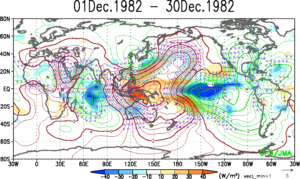
During this time, the SOI averaged -2.99 which is considered neutral. Very odd of what you typically see during strong El Nino events or even regular Nino events. In November of 1997, there were also strong easterly winds persistent across the eastern Nino regions as shown on the map below. I also included December 1997.


Here is a look of how the SOI trended in 1997-1998:

The SOI in Nov 1997 was around -15 then trended slightly upward to -9 in December all while strong easterly winds dominated the eastern Tropical Pacific. The core of the easterlies in 1997 were between 160W and 120W. In 1982 they were between 180 and 150W as seen below:

And from the SOI chart I posted above, 1982-1983 the SOI did not even budge. It was anomalously negative November, January, and February.
The latest GFS forecast is pretty unimpressive with the trade winds going into December. Easterlies continue to compose the eastern Nino region while a weak signal for westerlies exist west of 120W. I do not see how our current El Nino can continue maintaining this level of strength with trade winds looking like this. This to me is a better indication that we're very close if not already achieved a peak. Whereas, the SOI if you take it for what it is would suggest El Nino is reinvigorating.

This is why I feel the pattern is transitioning to what El Nino's should look like this time of year, especially strong one's. An AK vortex, Canadian ridge over east-central Canada, and +NAO/+AO conditions. The SOI is responding to that transition. Maybe more research needs to be done on my end, or I need to study the relationship better, but this SOI drop to me does not mean we'll see a surge in the PNA leading to a trough over the east. It's the atmosphere responding to the +ENSO.
_________________
_______________________________________________________________________________________________________
CLICK HERE to view NJ Strong Snowstorm Classifications
Frank_Wx- Godzilla Seeker
- Posts : 21305
Reputation : 328
Join date : 2013-01-05
Age : 31
Location : Jersey City, NJ -
Re: Long Range Thread 9.0
![]() by Frank_Wx Sun Nov 29, 2015 7:23 pm
by Frank_Wx Sun Nov 29, 2015 7:23 pm
_________________
_______________________________________________________________________________________________________
CLICK HERE to view NJ Strong Snowstorm Classifications
Frank_Wx- Godzilla Seeker
- Posts : 21305
Reputation : 328
Join date : 2013-01-05
Age : 31
Location : Jersey City, NJ -
Re: Long Range Thread 9.0
![]() by Dunnzoo Sun Nov 29, 2015 7:51 pm
by Dunnzoo Sun Nov 29, 2015 7:51 pm
_________________
Janet
Snowfall winter of 2023-2024 17.5"
Snowfall winter of 2022-2023 6.0"
Snowfall winter of 2021-2022 17.6" 1" sleet 2/25/22
Snowfall winter of 2020-2021 51.1"
Snowfall winter of 2019-2020 8.5"
Snowfall winter of 2018-2019 25.1"
Snowfall winter of 2017-2018 51.9"
Snowfall winter of 2016-2017 45.6"
Snowfall winter of 2015-2016 29.5"
Snowfall winter of 2014-2015 50.55"
Snowfall winter of 2013-2014 66.5"

Dunnzoo- Senior Enthusiast - Mod
- Posts : 4890
Reputation : 68
Join date : 2013-01-11
Age : 62
Location : Westwood, NJ
Re: Long Range Thread 9.0
![]() by Frank_Wx Sun Nov 29, 2015 8:14 pm
by Frank_Wx Sun Nov 29, 2015 8:14 pm
Dunnzoo wrote:Even though all these signals are starting to change doesn't it take a few weeks to affect our weather, so we would be on track to get more sustained cold after Christmas/early January as predicted?
Correct. There is definitely a lagg effect with zonal winds and even SOI. If a change occurs it will be around the time period you mentioned.
_________________
_______________________________________________________________________________________________________
CLICK HERE to view NJ Strong Snowstorm Classifications
Frank_Wx- Godzilla Seeker
- Posts : 21305
Reputation : 328
Join date : 2013-01-05
Age : 31
Location : Jersey City, NJ -
Re: Long Range Thread 9.0
![]() by Dunnzoo Sun Nov 29, 2015 8:23 pm
by Dunnzoo Sun Nov 29, 2015 8:23 pm
_________________
Janet
Snowfall winter of 2023-2024 17.5"
Snowfall winter of 2022-2023 6.0"
Snowfall winter of 2021-2022 17.6" 1" sleet 2/25/22
Snowfall winter of 2020-2021 51.1"
Snowfall winter of 2019-2020 8.5"
Snowfall winter of 2018-2019 25.1"
Snowfall winter of 2017-2018 51.9"
Snowfall winter of 2016-2017 45.6"
Snowfall winter of 2015-2016 29.5"
Snowfall winter of 2014-2015 50.55"
Snowfall winter of 2013-2014 66.5"
Dunnzoo- Senior Enthusiast - Mod
- Posts : 4890
Reputation : 68
Join date : 2013-01-11
Age : 62
Location : Westwood, NJ
Re: Long Range Thread 9.0
![]() by sroc4 Sun Nov 29, 2015 8:40 pm
by sroc4 Sun Nov 29, 2015 8:40 pm
Frank_Wx wrote:sroc4 wrote:Frank_Wx wrote:This response applies both to Scott and Doc. In my opinion, the drop of the SOI is more of an indication of our pattern heading into what typically resembles a strong El Nino during December. The pattern over the month of November resembled more of a La Niña if anything. During Nov the SOI, for the most part, was neutral and the MJO was very active. That is completely opposite of El Nino regimes, which should keep the SOI steadily negative and the MJO inactive (in the circle of death). Now we're seeing the SOI tank and the MJO head into the COD. Plus, LR guidance is accurately showing the AK Vortex and Canadian ridge.
Further, prior El Nino years like 83 and 97 experienced similar SOI drops and those two years had pretty different outcomes to their winter. In sum, I think the SOI drop is a response to our pattern headed to an El Nino configuration and NOT an indication we're seeing a pattern change to colder weather in the near future.
Like I mentioned, this pattern change will occur once the Stratosphere cooperates. The 2002-2003 correlation is interesting but I'm not buying it until other variables fall into place.
This may be true Frank but if you are going to discuss 97 and 83 you must point out the SST conf was drastically different; therefore, a much diff response to the SOI. Correct me if Im wrong but when you get a strong fluctuations to the SOI relative to the base state, in this case a crash, you end up with changes to the relative strength of the westerlies/easterlies. Like you noted this November the pattern was more typical of a Nino pattern despite the daily SOI values avging in a "neutral state". If you look the 30 day avg SOI as of October 31st it was -21.01. In less than one month the 30 day avg SOI went from -21.01 to -2.99. Noted in my prev post this is an unprecedented rise in an el nino year for the month of November. The behavior of the atmosphere being completely opposite of El Nino regimes I believe is more because of this unprecedented rise in the SOI relative to where it was back in OCT and enhanced Easterlies as a result. Enhanced easterlies and warm Indian Ocean SSTA has led to an enhanced MJO in the 2/3 phases for the better part of Nov. Now taking consideration of the current SST anomalies this year relative to say 97,( ie: much stronger SSTA in the Eastern NINO regions in 97 vs much stronger in the central Nino regions this year as well as the relationship with the Northern Pac SSTA alignment) I think this SOI drop might actually enhance the possibility for a trough in the east 2-3weeks from now for the following reasons.
Again correct me if I am wrong here, but the SOI crash is an indicator that the relative pressures are increasing over Darwin Australia, and dropping over Tahiti. The result of this would lead to a westerly wind burst as air tends to move from High pressure to low pressure. Now because of the SSTA alignment this burst in theory would lead to the westerly wind burst meeting the easterlies and enhanced tropical forcing further west towards the dateline and an enhancement to the Ak vortex further west near south of the Aleutians vs say 97 where the SSTA alignment led to the tropical forcing being much further east enhancing the trough set up over the west coast. At least in theory. I could be totally off base here.
The relationship between the SOI and westerly / easterly winds I may need to study more of. I understand how SOI is calculated - difference in pressures between Tahiti and Darwin - and realize -8 or lower points to El Nino conditions and +8 or greater signals La Nina. Let's take November 2015 for example. As you stated, there were strong easterly winds in the eastern Nino regions. This is 100% correct according to the graphs below.
During this time, the SOI averaged -2.99 which is considered neutral. Very odd of what you typically see during strong El Nino events or even regular Nino events. In November of 1997, there were also strong easterly winds persistent across the eastern Nino regions as shown on the map below. I also included December 1997.
Here is a look of how the SOI trended in 1997-1998:
The SOI in Nov 1997 was around -15 then trended slightly upward to -9 in December all while strong easterly winds dominated the eastern Tropical Pacific. The core of the easterlies in 1997 were between 160W and 120W. In 1982 they were between 180 and 150W as seen below:
And from the SOI chart I posted above, 1982-1983 the SOI did not even budge. It was anomalously negative November, January, and February.
The latest GFS forecast is pretty unimpressive with the trade winds going into December. Easterlies continue to compose the eastern Nino region while a weak signal for westerlies exist west of 120W. I do not see how our current El Nino can continue maintaining this level of strength with trade winds looking like this. This to me is a better indication that we're very close if not already achieved a peak. Whereas, the SOI if you take it for what it is would suggest El Nino is reinvigorating.
This is why I feel the pattern is transitioning to what El Nino's should look like this time of year, especially strong one's. An AK vortex, Canadian ridge over east-central Canada, and +NAO/+AO conditions. The SOI is responding to that transition. Maybe more research needs to be done on my end, or I need to study the relationship better, but this SOI drop to me does not mean we'll see a surge in the PNA leading to a trough over the east. It's the atmosphere responding to the +ENSO.
So to reiterate what you said above as a general rule an SOI of -8 or lower points to El Nino conditions and +8 or greater signals La Nina. However there is more to that statement. When looking at the SOI value one cant just look at the daily values, but the 30day and 90 mean values and beyond when in determining the conditions of the Tropical Pac (La Nina, El NINO or La Nada). The 30day mean is currently neutral at -2.99, but the 90 mean is still in El Nino territory at -13.79.
How strong the easterlies are and where they are really are nothing more than the sum of all vectors, westerly's plus easterlies, ie: 5mph westerly plus 10mph easterly leads to a net 5mph easterly in a given location. You can also have a net 5mph easterly if you have 50mph Easterly up against 45MPH westerly; however, there will most likely be enhanced rising air in that location vs the first example due to a more violent interaction between westerly and easterly vectors (the same way you would have more damage in a car crash using the same speeds).
The number generated to create the SOI value is also a complex one that involves the ratio of the pressure differences between Darwin and Tahiti. What I mean by that statement is the SOI value is the result of the relative pressure differences not necessarily the absolute values. For example: Darwins pressure is 1025mb compared to Tahiti's 1000mb. Lets say this leads to a negative SOI value of -10. If Tahiti's pressure remained the same but Darwin's went up the gradient between the two would increase forcing a more negative value. However; the same gradient would increase if Darwins pressure remained the same but Tahiti's lowered. The resulting SOI value would similarly drop because the gradient between the two locations became larger. BUT does that mean the conditions stay the same in the tropical pacific in one example to the next? The answer is a very complex no. I think the crazy relationship of this SOI value and easterly vs westerly, the MJO, and the net sum of the Walker Circulation, Hadley cells etc shows us just how complex this all is. I feel like I am just starting to scratch the surface of understanding these things, but enjoy the learning process.
So I absolutely agree with you Frank in that I think the trends in the SOI right now is one that is telling us the peak of this Nino has arrived and we may be seeing the reversal of it as we speak, but we wont know that until we see where the 90day avg SOI goes over time. With that said the current dramatic drop in the SOI value is a normal transient fluctuation in an otherwise trend towards neutral and eventual La Nina territory by next summer or fall as historically it is not uncommon after strong El Ninos to rapidly flip to a Nina. So as the easterlies become more dominant the strength of these westerly bursts, (as indicated by the transient SOI crash), where it is located and the relative strength and position of the Easterly wind component will dictate if this particular SOI crash will end up enhancing the trough in a favorable position in the N Pac to lead us to an eastern CONUS trough. My argument is the SOI crash will lead to a transient shift in the pattern. Its only transient because the strength of the Nino is still dominating the pattern overall. So if we get a few more days of a strong neg SOI before it comes back towards neutral again the current SSTA in both the Trop Pac and N Pac are such that we could see a transient cold shot with a poss storm threat or two because the forcing should occur between the dateline and about 120W. Of course the strength of the NINo could totally poo poo this little SOI crash theory as well.
_________________
"In weather and in life, there's no winning and losing; there's only winning and learning."
WINTER 2012/2013 TOTALS 43.65"WINTER 2017/2018 TOTALS 62.85" WINTER 2022/2023 TOTALS 4.9"
WINTER 2013/2014 TOTALS 64.85"WINTER 2018/2019 TOTALS 14.25" WINTER 2023/2024 TOTALS 13.1"
WINTER 2014/2015 TOTALS 71.20"WINTER 2019/2020 TOTALS 6.35"
WINTER 2015/2016 TOTALS 35.00"WINTER 2020/2021 TOTALS 37.75"
WINTER 2016/2017 TOTALS 42.25"WINTER 2021/2022 TOTALS 31.65"
sroc4- Admin
- Posts : 8331
Reputation : 301
Join date : 2013-01-07
Location : Wading River, LI
Re: Long Range Thread 9.0
![]() by Frank_Wx Sun Nov 29, 2015 9:17 pm
by Frank_Wx Sun Nov 29, 2015 9:17 pm
sroc4 wrote:Frank_Wx wrote:sroc4 wrote:Frank_Wx wrote:This response applies both to Scott and Doc. In my opinion, the drop of the SOI is more of an indication of our pattern heading into what typically resembles a strong El Nino during December. The pattern over the month of November resembled more of a La Niña if anything. During Nov the SOI, for the most part, was neutral and the MJO was very active. That is completely opposite of El Nino regimes, which should keep the SOI steadily negative and the MJO inactive (in the circle of death). Now we're seeing the SOI tank and the MJO head into the COD. Plus, LR guidance is accurately showing the AK Vortex and Canadian ridge.
Further, prior El Nino years like 83 and 97 experienced similar SOI drops and those two years had pretty different outcomes to their winter. In sum, I think the SOI drop is a response to our pattern headed to an El Nino configuration and NOT an indication we're seeing a pattern change to colder weather in the near future.
Like I mentioned, this pattern change will occur once the Stratosphere cooperates. The 2002-2003 correlation is interesting but I'm not buying it until other variables fall into place.
This may be true Frank but if you are going to discuss 97 and 83 you must point out the SST conf was drastically different; therefore, a much diff response to the SOI. Correct me if Im wrong but when you get a strong fluctuations to the SOI relative to the base state, in this case a crash, you end up with changes to the relative strength of the westerlies/easterlies. Like you noted this November the pattern was more typical of a Nino pattern despite the daily SOI values avging in a "neutral state". If you look the 30 day avg SOI as of October 31st it was -21.01. In less than one month the 30 day avg SOI went from -21.01 to -2.99. Noted in my prev post this is an unprecedented rise in an el nino year for the month of November. The behavior of the atmosphere being completely opposite of El Nino regimes I believe is more because of this unprecedented rise in the SOI relative to where it was back in OCT and enhanced Easterlies as a result. Enhanced easterlies and warm Indian Ocean SSTA has led to an enhanced MJO in the 2/3 phases for the better part of Nov. Now taking consideration of the current SST anomalies this year relative to say 97,( ie: much stronger SSTA in the Eastern NINO regions in 97 vs much stronger in the central Nino regions this year as well as the relationship with the Northern Pac SSTA alignment) I think this SOI drop might actually enhance the possibility for a trough in the east 2-3weeks from now for the following reasons.
Again correct me if I am wrong here, but the SOI crash is an indicator that the relative pressures are increasing over Darwin Australia, and dropping over Tahiti. The result of this would lead to a westerly wind burst as air tends to move from High pressure to low pressure. Now because of the SSTA alignment this burst in theory would lead to the westerly wind burst meeting the easterlies and enhanced tropical forcing further west towards the dateline and an enhancement to the Ak vortex further west near south of the Aleutians vs say 97 where the SSTA alignment led to the tropical forcing being much further east enhancing the trough set up over the west coast. At least in theory. I could be totally off base here.
The relationship between the SOI and westerly / easterly winds I may need to study more of. I understand how SOI is calculated - difference in pressures between Tahiti and Darwin - and realize -8 or lower points to El Nino conditions and +8 or greater signals La Nina. Let's take November 2015 for example. As you stated, there were strong easterly winds in the eastern Nino regions. This is 100% correct according to the graphs below.
During this time, the SOI averaged -2.99 which is considered neutral. Very odd of what you typically see during strong El Nino events or even regular Nino events. In November of 1997, there were also strong easterly winds persistent across the eastern Nino regions as shown on the map below. I also included December 1997.
Here is a look of how the SOI trended in 1997-1998:
The SOI in Nov 1997 was around -15 then trended slightly upward to -9 in December all while strong easterly winds dominated the eastern Tropical Pacific. The core of the easterlies in 1997 were between 160W and 120W. In 1982 they were between 180 and 150W as seen below:
And from the SOI chart I posted above, 1982-1983 the SOI did not even budge. It was anomalously negative November, January, and February.
The latest GFS forecast is pretty unimpressive with the trade winds going into December. Easterlies continue to compose the eastern Nino region while a weak signal for westerlies exist west of 120W. I do not see how our current El Nino can continue maintaining this level of strength with trade winds looking like this. This to me is a better indication that we're very close if not already achieved a peak. Whereas, the SOI if you take it for what it is would suggest El Nino is reinvigorating.
This is why I feel the pattern is transitioning to what El Nino's should look like this time of year, especially strong one's. An AK vortex, Canadian ridge over east-central Canada, and +NAO/+AO conditions. The SOI is responding to that transition. Maybe more research needs to be done on my end, or I need to study the relationship better, but this SOI drop to me does not mean we'll see a surge in the PNA leading to a trough over the east. It's the atmosphere responding to the +ENSO.
So to reiterate what you said above as a general rule an SOI of -8 or lower points to El Nino conditions and +8 or greater signals La Nina. However there is more to that statement. When looking at the SOI value one cant just look at the daily values, but the 30day and 90 mean values and beyond when in determining the conditions of the Tropical Pac (La Nina, El NINO or La Nada). The 30day mean is currently neutral at -2.99, but the 90 mean is still in El Nino territory at -13.79.
How strong the easterlies are and where they are really are nothing more than the sum of all vectors, westerly's plus easterlies, ie: 5mph westerly plus 10mph easterly leads to a net 5mph easterly in a given location. You can also have a net 5mph easterly if you have 50mph Easterly up against 45MPH westerly; however, there will most likely be enhanced rising air in that location vs the first example due to a more violent interaction between westerly and easterly vectors (the same way you would have more damage in a car crash using the same speeds).
The number generated to create the SOI value is also a complex one that involves the ratio of the pressure differences between Darwin and Tahiti. What I mean by that statement is the SOI value is the result of the relative pressure differences not necessarily the absolute values. For example: Darwins pressure is 1025mb compared to Tahiti's 1000mb. Lets say this leads to a negative SOI value of -10. If Tahiti's pressure remained the same but Darwin's went up the gradient between the two would increase forcing a more negative value. However; the same gradient would increase if Darwins pressure remained the same but Tahiti's lowered. The resulting SOI value would similarly drop because the gradient between the two locations became larger. BUT does that mean the conditions stay the same in the tropical pacific in one example to the next? The answer is a very complex no. I think the crazy relationship of this SOI value and easterly vs westerly, the MJO, and the net sum of the Walker Circulation, Hadley cells etc shows us just how complex this all is. I feel like I am just starting to scratch the surface of understanding these things, but enjoy the learning process.
So I absolutely agree with you Frank in that I think the trends in the SOI right now is one that is telling us the peak of this Nino has arrived and we may be seeing the reversal of it as we speak, but we wont know that until we see where the 90day avg SOI goes over time. With that said the current dramatic drop in the SOI value is a normal transient fluctuation in an otherwise trend towards neutral and eventual La Nina territory by next summer or fall as historically it is not uncommon after strong El Ninos to rapidly flip to a Nina. So as the easterlies become more dominant the strength of these westerly bursts, (as indicated by the transient SOI crash), where it is located and the relative strength and position of the Easterly wind component will dictate if this particular SOI crash will end up enhancing the trough in a favorable position in the N Pac to lead us to an eastern CONUS trough. My argument is the SOI crash will lead to a transient shift in the pattern. Its only transient because the strength of the Nino is still dominating the pattern overall. So if we get a few more days of a strong neg SOI before it comes back towards neutral again the current SSTA in both the Trop Pac and N Pac are such that we could see a transient cold shot with a poss storm threat or two because the forcing should occur between the dateline and about 120W. Of course the strength of the NINo could totally poo poo this little SOI crash theory as well.
I kind of feel like we're saying the same thing. Difference is you are using SOI in a more granular manner to figure out El Nino's peak / intensity while I'm using zonal trade wind anomalies to draw my conclusions (you also use trade winds and tie them back to the SOI and overall pressures between Tahiti and Darwin which is pretty awesome). I'm still a little hesitant because we saw a decent amount, albeit weak, tropical forcing between the Dateline and 120W in November and that did not seem to promote sustained troughing over the eastern CONUS. Hence why I already feel the STJ coupled with the AK Vortex will be the dominant drivers heading into December. We cannot ignore the fact either that the upper air pattern the first couple of weeks of December is polar opposite of what we saw in November. The Aleutian trough is now an Alaskan Vortex, the negative EPO is now a central Canadian ridge...the Atlantic remains the same though (+NAO/+AO). We'll see if the stronger tropical forcing the GFS is projecting to begin December could lead to some transient shots by the middle of the month. It does appear some ensembles are trending in that direction. Either way, the state of the Stratosphere indicates we're still a good deal away from seeing a complete pattern change. I will talk more about this in tomorrow' Mo Mo.
_________________
_______________________________________________________________________________________________________
CLICK HERE to view NJ Strong Snowstorm Classifications
Frank_Wx- Godzilla Seeker
- Posts : 21305
Reputation : 328
Join date : 2013-01-05
Age : 31
Location : Jersey City, NJ -
Re: Long Range Thread 9.0
![]() by amugs Sun Nov 29, 2015 9:31 pm
by amugs Sun Nov 29, 2015 9:31 pm


_________________
Mugs
AKA:King: Snow Weenie
Self Proclaimed
WINTER 2014-15 : 55.12" +.02 for 6 coatings (avg. 35")
WINTER 2015-16 Total - 29.8" (Avg 35")
WINTER 2016-17 : 39.5" so far
amugs- Advanced Forecaster - Mod
- Posts : 15093
Reputation : 213
Join date : 2013-01-07
Age : 54
Location : Hillsdale,NJ
Re: Long Range Thread 9.0
![]() by sroc4 Sun Nov 29, 2015 9:49 pm
by sroc4 Sun Nov 29, 2015 9:49 pm
Frank_Wx wrote:Also, glad we can have these types of discussions because doing the research is a big help in helping me better understand GWO (global wind oscillation)
Ditto Frank. I'd like to hear Rb chime in if he has the time.
_________________
"In weather and in life, there's no winning and losing; there's only winning and learning."
WINTER 2012/2013 TOTALS 43.65"WINTER 2017/2018 TOTALS 62.85" WINTER 2022/2023 TOTALS 4.9"
WINTER 2013/2014 TOTALS 64.85"WINTER 2018/2019 TOTALS 14.25" WINTER 2023/2024 TOTALS 13.1"
WINTER 2014/2015 TOTALS 71.20"WINTER 2019/2020 TOTALS 6.35"
WINTER 2015/2016 TOTALS 35.00"WINTER 2020/2021 TOTALS 37.75"
WINTER 2016/2017 TOTALS 42.25"WINTER 2021/2022 TOTALS 31.65"
sroc4- Admin
- Posts : 8331
Reputation : 301
Join date : 2013-01-07
Location : Wading River, LI
Re: Long Range Thread 9.0
![]() by Frank_Wx Sun Nov 29, 2015 9:50 pm
by Frank_Wx Sun Nov 29, 2015 9:50 pm
amugs wrote:If one were to believe the CFS it is saying at the end of the month we start to see things go to normal to below normal temps wise:
If the CFS is hinting at a pattern change, we must be getting close, no??
_________________
_______________________________________________________________________________________________________
CLICK HERE to view NJ Strong Snowstorm Classifications
Frank_Wx- Godzilla Seeker
- Posts : 21305
Reputation : 328
Join date : 2013-01-05
Age : 31
Location : Jersey City, NJ -
Re: Long Range Thread 9.0
![]() by Frank_Wx Sun Nov 29, 2015 9:51 pm
by Frank_Wx Sun Nov 29, 2015 9:51 pm
sroc4 wrote:Frank_Wx wrote:Also, glad we can have these types of discussions because doing the research is a big help in helping me better understand GWO (global wind oscillation)
Ditto Frank. I'd like to hear Rb chime in if he has the time.
rb has vanished. We need the OT Island crew to send out a search for him and Snow Man. CP or Doc, please make this happen.
Thanks.
_________________
_______________________________________________________________________________________________________
CLICK HERE to view NJ Strong Snowstorm Classifications
Frank_Wx- Godzilla Seeker
- Posts : 21305
Reputation : 328
Join date : 2013-01-05
Age : 31
Location : Jersey City, NJ -
Re: Long Range Thread 9.0
![]() by docstox12 Sun Nov 29, 2015 11:41 pm
by docstox12 Sun Nov 29, 2015 11:41 pm
Doc's presentation included the idea that this rapid , albeit transient, severe drop, in the SOI value in the overall Nino situation can result in a transient favorable situation for snow.Perhaps that occured in the Feb 1983 snowstorm within that '82-'83 Nino year.
You guys are unbelievably awesome with this research.I feel like I am in Meteorology College.I am slowly picking up bits and pieces on how just so complex all these variables are that make up winter weather up here.

docstox12- Wx Statistician Guru
- Posts : 8504
Reputation : 222
Join date : 2013-01-07
Age : 73
Location : Monroe NY
Re: Long Range Thread 9.0
![]() by rb924119 Mon Nov 30, 2015 8:37 am
by rb924119 Mon Nov 30, 2015 8:37 am
Frank_Wx wrote:sroc4 wrote:Frank_Wx wrote:Also, glad we can have these types of discussions because doing the research is a big help in helping me better understand GWO (global wind oscillation)
Ditto Frank. I'd like to hear Rb chime in if he has the time.
rb has vanished. We need the OT Island crew to send out a search for him and Snow Man. CP or Doc, please make this happen.
Thanks.
Sorry fellas, I was attempting to hibernate through these pitiful next three weeks and then wake up to the magic of a changing pattern lmfao No, in all honesty I've been on, just reading though. I haven't had much time to do otherwise since Thanksgiving with my work schedule. Besides, you guys are sustaining quite the discussion anyway :p
rb924119- Meteorologist

- Posts : 6889
Reputation : 194
Join date : 2013-02-06
Age : 32
Location : Greentown, Pa
Re: Long Range Thread 9.0
![]() by amugs Mon Nov 30, 2015 10:23 am
by amugs Mon Nov 30, 2015 10:23 am
rb924119 wrote:Frank_Wx wrote:sroc4 wrote:Frank_Wx wrote:Also, glad we can have these types of discussions because doing the research is a big help in helping me better understand GWO (global wind oscillation)
Ditto Frank. I'd like to hear Rb chime in if he has the time.
rb has vanished. We need the OT Island crew to send out a search for him and Snow Man. CP or Doc, please make this happen.
Thanks.
Sorry fellas, I was attempting to hibernate through these pitiful next three weeks and then wake up to the magic of a changing pattern lmfao No, in all honesty I've been on, just reading though. I haven't had much time to do otherwise since Thanksgiving with my work schedule. Besides, you guys are sustaining quite the discussion anyway :p
One down and one to go!!
_________________
Mugs
AKA:King: Snow Weenie
Self Proclaimed
WINTER 2014-15 : 55.12" +.02 for 6 coatings (avg. 35")
WINTER 2015-16 Total - 29.8" (Avg 35")
WINTER 2016-17 : 39.5" so far
amugs- Advanced Forecaster - Mod
- Posts : 15093
Reputation : 213
Join date : 2013-01-07
Age : 54
Location : Hillsdale,NJ
Re: Long Range Thread 9.0
![]() by Math23x7 Mon Nov 30, 2015 9:17 pm
by Math23x7 Mon Nov 30, 2015 9:17 pm
Math23x7- Wx Statistician Guru
- Posts : 2379
Reputation : 68
Join date : 2013-01-08
Re: Long Range Thread 9.0
![]() by Frank_Wx Mon Nov 30, 2015 9:36 pm
by Frank_Wx Mon Nov 30, 2015 9:36 pm
Math23x7 wrote:If the CPC's 14-day teleconnection spreads are accurate, then it is possible that we could have an all-time record high NAO reading. The highest occured on November 9th, 1978 when the NAO was +2.52!!! This weekend, the spaghetti plots on the chart all have it between +2 and +3!!!
Great. GREAT MIKE THANKS
_________________
_______________________________________________________________________________________________________
CLICK HERE to view NJ Strong Snowstorm Classifications
Frank_Wx- Godzilla Seeker
- Posts : 21305
Reputation : 328
Join date : 2013-01-05
Age : 31
Location : Jersey City, NJ -
Re: Long Range Thread 9.0
![]() by Math23x7 Mon Nov 30, 2015 9:49 pm
by Math23x7 Mon Nov 30, 2015 9:49 pm
Frank_Wx wrote:Math23x7 wrote:If the CPC's 14-day teleconnection spreads are accurate, then it is possible that we could have an all-time record high NAO reading. The highest occured on November 9th, 1978 when the NAO was +2.52!!! This weekend, the spaghetti plots on the chart all have it between +2 and +3!!!
Great. GREAT MIKE THANKS


Math23x7- Wx Statistician Guru
- Posts : 2379
Reputation : 68
Join date : 2013-01-08
Re: Long Range Thread 9.0
![]() by Frank_Wx Mon Nov 30, 2015 10:42 pm
by Frank_Wx Mon Nov 30, 2015 10:42 pm


And to be honest, I'm not really thrilled about the look they give between Christmas and New Years. Luckily that's still pretty far out for changes to still happen.

_________________
_______________________________________________________________________________________________________
CLICK HERE to view NJ Strong Snowstorm Classifications
Frank_Wx- Godzilla Seeker
- Posts : 21305
Reputation : 328
Join date : 2013-01-05
Age : 31
Location : Jersey City, NJ -
Re: Long Range Thread 9.0
![]() by CPcantmeasuresnow Tue Dec 01, 2015 4:31 am
by CPcantmeasuresnow Tue Dec 01, 2015 4:31 am

CPcantmeasuresnow- Wx Statistician Guru
- Posts : 7274
Reputation : 230
Join date : 2013-01-07
Age : 103
Location : Eastern Orange County, NY
Re: Long Range Thread 9.0
![]() by rb924119 Tue Dec 01, 2015 8:06 am
by rb924119 Tue Dec 01, 2015 8:06 am
Frank_Wx wrote:Word around the weather world tonight is about how awful the latest EURO weeklies look. Here's some images 1 week apart from eachother. Take note of time stamps.
And to be honest, I'm not really thrilled about the look they give between Christmas and New Years. Luckily that's still pretty far out for changes to still happen.
Hey Frank, all hope may not be lost. When taken at face value, no; it looks like even the end of December is going to H@ll in a hand basket. BUT, take notice of the trends of the 500 hPa positive anomalies. They started in the northern Midwest; this latest run the core is now centered right near 60N. The trend is moving the right direction; toward the pole. Even in the GooFuS, this trend is evident. Why am I bringing this up? Here's why:

Look at the winds and fluxes toward mid-month......winds start dropping and fluxes start increasing, and you can also see the rises in heights. Also notice the time period; both on your graphics and mine, the time period is mid-month. Remember when all that snow cover started to rapidly stack up in the NH, specifically Siberia? Mid-month of October through the present. I think we might be seeing the models attempting to pick up on these vertical fluxes in the long range. You can also see the trends in the teleconnections, for the most part, heading in the right directions: NAO/AO/EPO trending toward negative values. The PNA is the only uncooperative one, but I think that could end up reversing if we start to see this consistently showing up.
rb924119- Meteorologist
- Posts : 6889
Reputation : 194
Join date : 2013-02-06
Age : 32
Location : Greentown, Pa
Re: Long Range Thread 9.0
![]() by amugs Tue Dec 01, 2015 8:45 am
by amugs Tue Dec 01, 2015 8:45 am
_________________
Mugs
AKA:King: Snow Weenie
Self Proclaimed
WINTER 2014-15 : 55.12" +.02 for 6 coatings (avg. 35")
WINTER 2015-16 Total - 29.8" (Avg 35")
WINTER 2016-17 : 39.5" so far
amugs- Advanced Forecaster - Mod
- Posts : 15093
Reputation : 213
Join date : 2013-01-07
Age : 54
Location : Hillsdale,NJ
Page 8 of 40 • 1 ... 5 ... 7, 8, 9 ... 24 ... 40 ![]()
|
|
|