
 Search
Long Range Thread 9.0
Page 31 of 40 •  1 ... 17 ... 30, 31, 32 ... 35 ... 40
 ![]()
Re: Long Range Thread 9.0
![]() by amugs Fri Dec 25, 2015 11:14 pm
by amugs Fri Dec 25, 2015 11:14 pm
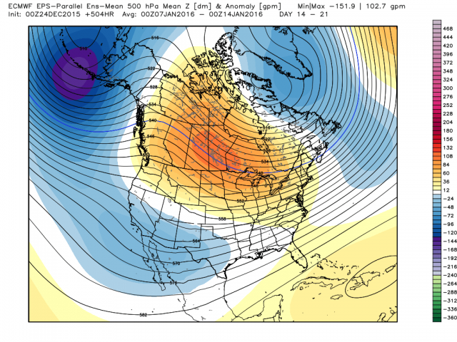
well here is the last one

Splitting the uprights like Janakowski of the Oakland Raiders last night on ot ftw
amugs- Advanced Forecaster - Mod

- Posts : 15093
Join date : 2013-01-07
Re: Long Range Thread 9.0
![]() by amugs Fri Dec 25, 2015 11:22 pm
by amugs Fri Dec 25, 2015 11:22 pm
from wxbell mjo yeah baby

AO best look in months

NAO bring it baby

PNA OH YEAH

FINALLY EPO TRES FOR TRES

not too shabby -euro weeklies showing a good to great ride from about jan 10ish to feb 10ish
amugs- Advanced Forecaster - Mod
- Posts : 15093
Join date : 2013-01-07
Re: Long Range Thread 9.0
![]() by Guest Sat Dec 26, 2015 8:46 am
by Guest Sat Dec 26, 2015 8:46 am
Guest- Guest
Re: Long Range Thread 9.0
![]() by algae888 Sat Dec 26, 2015 10:09 am
by algae888 Sat Dec 26, 2015 10:09 am

algae888- Advanced Forecaster

- Posts : 5311
Reputation : 46
Join date : 2013-02-05
Age : 61
Location : mt. vernon, new york
Re: Long Range Thread 9.0
![]() by skinsfan1177 Sat Dec 26, 2015 10:27 am
by skinsfan1177 Sat Dec 26, 2015 10:27 am

skinsfan1177- Senior Enthusiast

- Posts : 4485
Reputation : 35
Join date : 2013-01-07
Age : 46
Location : Point Pleasant Boro
Re: Long Range Thread 9.0
![]() by amugs Sat Dec 26, 2015 10:34 am
by amugs Sat Dec 26, 2015 10:34 am
skinsfan1177 wrote:Is their any sign of a -NAO wouldn't that be key for storms to come up the coast
As per this indicy it is coming:

_________________
Mugs
AKA:King: Snow Weenie
Self Proclaimed
WINTER 2014-15 : 55.12" +.02 for 6 coatings (avg. 35")
WINTER 2015-16 Total - 29.8" (Avg 35")
WINTER 2016-17 : 39.5" so far

amugs- Advanced Forecaster - Mod
- Posts : 15093
Reputation : 213
Join date : 2013-01-07
Age : 54
Location : Hillsdale,NJ
Re: Long Range Thread 9.0
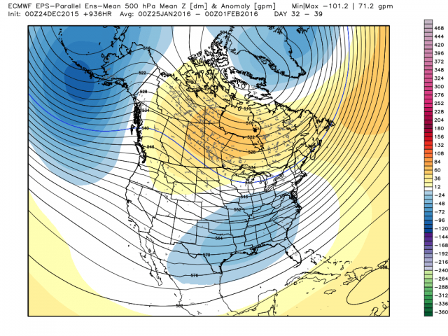
![]() by amugs Sat Dec 26, 2015 10:39 am
by amugs Sat Dec 26, 2015 10:39 am


.png)
10000000000000x better than what we are in and it is holding steadfast on the AL vortex retrograding SW of teh ALeutians, pumpion the -EPO and +PNA along with the trough over SE.
_________________
Mugs
AKA:King: Snow Weenie
Self Proclaimed
WINTER 2014-15 : 55.12" +.02 for 6 coatings (avg. 35")
WINTER 2015-16 Total - 29.8" (Avg 35")
WINTER 2016-17 : 39.5" so far
amugs- Advanced Forecaster - Mod
- Posts : 15093
Reputation : 213
Join date : 2013-01-07
Age : 54
Location : Hillsdale,NJ
Re: Long Range Thread 9.0
![]() by skinsfan1177 Sat Dec 26, 2015 10:45 am
by skinsfan1177 Sat Dec 26, 2015 10:45 am
skinsfan1177- Senior Enthusiast
- Posts : 4485
Reputation : 35
Join date : 2013-01-07
Age : 46
Location : Point Pleasant Boro
Re: Long Range Thread 9.0
![]() by Frank_Wx Sat Dec 26, 2015 11:18 am
by Frank_Wx Sat Dec 26, 2015 11:18 am

_________________
_______________________________________________________________________________________________________
CLICK HERE to view NJ Strong Snowstorm Classifications

Frank_Wx- Godzilla Seeker

- Posts : 21305
Reputation : 328
Join date : 2013-01-05
Age : 31
Location : Jersey City, NJ -

Re: Long Range Thread 9.0
![]() by Frank_Wx Sat Dec 26, 2015 11:31 am
by Frank_Wx Sat Dec 26, 2015 11:31 am


_________________
_______________________________________________________________________________________________________
CLICK HERE to view NJ Strong Snowstorm Classifications
Frank_Wx- Godzilla Seeker
- Posts : 21305
Reputation : 328
Join date : 2013-01-05
Age : 31
Location : Jersey City, NJ -
chief7- Posts : 132
Reputation : 0
Join date : 2013-11-10
Location : Langhorne pa
Re: Long Range Thread 9.0
![]() by algae888 Sat Dec 26, 2015 4:40 pm
by algae888 Sat Dec 26, 2015 4:40 pm
algae888- Advanced Forecaster
- Posts : 5311
Reputation : 46
Join date : 2013-02-05
Age : 61
Location : mt. vernon, new york
Re: Long Range Thread 9.0
![]() by Frank_Wx Sat Dec 26, 2015 5:30 pm
by Frank_Wx Sat Dec 26, 2015 5:30 pm

_________________
_______________________________________________________________________________________________________
CLICK HERE to view NJ Strong Snowstorm Classifications
Frank_Wx- Godzilla Seeker
- Posts : 21305
Reputation : 328
Join date : 2013-01-05
Age : 31
Location : Jersey City, NJ -
Re: Long Range Thread 9.0
![]() by sroc4 Sat Dec 26, 2015 7:13 pm
by sroc4 Sat Dec 26, 2015 7:13 pm
_________________
"In weather and in life, there's no winning and losing; there's only winning and learning."
WINTER 2012/2013 TOTALS 43.65"WINTER 2017/2018 TOTALS 62.85" WINTER 2022/2023 TOTALS 4.9"
WINTER 2013/2014 TOTALS 64.85"WINTER 2018/2019 TOTALS 14.25" WINTER 2023/2024 TOTALS 13.1"
WINTER 2014/2015 TOTALS 71.20"WINTER 2019/2020 TOTALS 6.35"
WINTER 2015/2016 TOTALS 35.00"WINTER 2020/2021 TOTALS 37.75"
WINTER 2016/2017 TOTALS 42.25"WINTER 2021/2022 TOTALS 31.65"

sroc4- Admin
- Posts : 8331
Reputation : 301
Join date : 2013-01-07
Location : Wading River, LI
Re: Long Range Thread 9.0
![]() by Frank_Wx Sat Dec 26, 2015 8:44 pm
by Frank_Wx Sat Dec 26, 2015 8:44 pm
The upcoming Tropospheric pattern - to me - will bring normal to below normal weather after New Years but struggle to see cyclogenesis occur along the east coast. Reason being the lack of well defined Aleutian trough. The low heights progged over the Aleutians in early January are a result of intense pieces of H5 energy breaking off from the western Arctic Tropospheric PV. Until a better defined / organized / anomalous trough develops there, the EPO/PNA ridges will remain transient. This should become apparent once the MJO deamplifies or exits phase 7. Additionally, the NAO looks to remain positive. It will be difficult to see trough amplification over the eastern U.S. with these signals prior to a SSWE and under strong El Nino conditions. Not to say there won't be opportunities for wintry weather, such as what we'll see Tuesday morning, but the Godzilla-type storms will wait until late Jan into February IMO.
I know people are not necessarily chasing Godzilla's, but I've seen some posts insinuating the upcoming pattern flip in early January looks "cold and dry." This may be true (though I caution it won't take much for storms to show up in the short range thanks to the STJ), but the upcoming pattern is NOT the pattern most pro's are expecting to be our true winter pattern. The pattern I'm expecting later this season will have an anomalous trough over the Aleutians, a N-S oriented PNA ridge (mainly over western Canada), and a favorably positioned southeastern trough. The weakening of El Nino and full-scale SSW will get us there. But as I've said numerous times, this is a step-down pattern that will take time to evolve. Phase 1 will come the 1st two weeks of January. Phase 2 will come the third week. And the last phase will come week 4 to early February.
I'll have all the details in the next Mo Mo blog.

_________________
_______________________________________________________________________________________________________
CLICK HERE to view NJ Strong Snowstorm Classifications
Frank_Wx- Godzilla Seeker
- Posts : 21305
Reputation : 328
Join date : 2013-01-05
Age : 31
Location : Jersey City, NJ -
Re: Long Range Thread 9.0
![]() by Frank_Wx Sat Dec 26, 2015 8:50 pm
by Frank_Wx Sat Dec 26, 2015 8:50 pm
sroc4 wrote:Honestly Frank I'm not sure we will need it. The main driver the last two years as we were headed into the second half of winter has been the -EPO compliments of the positive PDO and the trop pac forcing near the dateline. Although weaker than last year the PDO region is still mod warm and should def support a sustained negative EPO. Beginning Jan the EPO ridge should start to drive cold air into the east. Similar to last winter in the early going it comes and backs off and comes again and again relentlessly. Each time dropping SST off the coast and offering up opportunities for snow chances. As the snow pack builds in the NE further and further south each push of the cold air becomes less and less transient, because as they say of the cold and snow it breeds cold and snow. Unlike last year where El Niño was in its infancy and the STJ had not yet really gotten going, this year we are all systems go regarding the STJ so hopefully we have more opportunity for more intense cyclogenisis and bigger snow accumulations vs the mild mod events created by the sfwe events frequented last year. This year it looks way more likely we get the -AO. God willing if the stratosphere responds as is possible given current observations and modeling and we get the -NAO even if only for a 3-4 week period some time in late Jan or February we really have a chance for some historic storms and snowfall totals. This is not just a snow weenies wish but a distinct possibility of becoming a reality given everything I've researched, what I see in the current medium and LR modeling, and what very smart individuals both amateur and pro mets have to say. Again even without a neg NAO I am still very confident in above avg snowfall. I of course may run into a two by four up side the head as we head deeper into the season but I seriously doubt it. I am very pleased with where we are right now.
I agree. I wasn't insinuating the +NAO is a bad thing. It would certainly help, but as long as there is an anomalous ridge in the west we should be ok.
_________________
_______________________________________________________________________________________________________
CLICK HERE to view NJ Strong Snowstorm Classifications
Frank_Wx- Godzilla Seeker
- Posts : 21305
Reputation : 328
Join date : 2013-01-05
Age : 31
Location : Jersey City, NJ -
Re: Long Range Thread 9.0
![]() by Frank_Wx Sat Dec 26, 2015 9:09 pm
by Frank_Wx Sat Dec 26, 2015 9:09 pm
.png.140f6596c775e72a24e02af2797a4bc0.png)
_________________
_______________________________________________________________________________________________________
CLICK HERE to view NJ Strong Snowstorm Classifications
Frank_Wx- Godzilla Seeker
- Posts : 21305
Reputation : 328
Join date : 2013-01-05
Age : 31
Location : Jersey City, NJ -
Re: Long Range Thread 9.0
![]() by Snow88 Sat Dec 26, 2015 9:15 pm
by Snow88 Sat Dec 26, 2015 9:15 pm
"*** ALERT ! MAJOR PATTERN CHANGE SEEMS LIKELY FOR JAN/ FEB 2016 --- my latest DEC 26 UPDATE!!!
QBO is collapsing ...the Polar Vortex is going to split and the pattern will get get nasty the east by Mid Jan"
https://www.wxrisk.com/the-wxrisk-com-snowstorm-page/

Snow88- Senior Enthusiast
- Posts : 2193
Reputation : 4
Join date : 2013-01-09
Age : 35
Location : Brooklyn, NY
Re: Long Range Thread 9.0
![]() by sroc4 Sat Dec 26, 2015 9:51 pm
by sroc4 Sat Dec 26, 2015 9:51 pm
Frank_Wx wrote:sroc4 wrote:Honestly Frank I'm not sure we will need it. The main driver the last two years as we were headed into the second half of winter has been the -EPO compliments of the positive PDO and the trop pac forcing near the dateline. Although weaker than last year the PDO region is still mod warm and should def support a sustained negative EPO. Beginning Jan the EPO ridge should start to drive cold air into the east. Similar to last winter in the early going it comes and backs off and comes again and again relentlessly. Each time dropping SST off the coast and offering up opportunities for snow chances. As the snow pack builds in the NE further and further south each push of the cold air becomes less and less transient, because as they say of the cold and snow it breeds cold and snow. Unlike last year where El Niño was in its infancy and the STJ had not yet really gotten going, this year we are all systems go regarding the STJ so hopefully we have more opportunity for more intense cyclogenisis and bigger snow accumulations vs the mild mod events created by the sfwe events frequented last year. This year it looks way more likely we get the -AO. God willing if the stratosphere responds as is possible given current observations and modeling and we get the -NAO even if only for a 3-4 week period some time in late Jan or February we really have a chance for some historic storms and snowfall totals. This is not just a snow weenies wish but a distinct possibility of becoming a reality given everything I've researched, what I see in the current medium and LR modeling, and what very smart individuals both amateur and pro mets have to say. Again even without a neg NAO I am still very confident in above avg snowfall. I of course may run into a two by four up side the head as we head deeper into the season but I seriously doubt it. I am very pleased with where we are right now.
I agree. I wasn't insinuating the +NAO is a bad thing. It would certainly help, but as long as there is an anomalous ridge in the west we should be ok.
i def didn't think you were insinuating that a pos NAO was a bad thing. I'm sorry if it came across that way. I simply want folks to understand that as long as we have that strong Neg EPO/+PNA signal, esp if it connects overtop with the Barents ridge like is shown in the LR ensemble forecasts, the cold air will make its push and winter weather opportunities will present themselves. I also want folks to know that this IS NOT AND WILL NOT be like December. When I say transient I mean initially these cold shots drive in below normal temps and then moderate back to normal to slight above normal, not back to the SE death ridge and 10-30*f above normal....so long as the ridging holds in the NW CONUS And Western Canada/Alaska which looks to hold strong at least the first 10-14 d of Jan.
The -NAO would be icing on the cake. Think of this teleconnection as the back board for the cold air. Without it cold shots and energy associated with it come and go escaping north and east. Look at my signature at my snow totals from last year. That's what happens when we get snow in negative EPO but +NAO pattern small to moderate snow totals. With a -NAO the cold air kind of tumbles back on itself as it runs up against the block. That same idea leads to more intense cyclogenisis on or near the coast and Godzilla and/or Frankzilla Storm total potential (12-24"= Godzilla. 24+=Frankzilla)
no matter how it turns out this year will be very interesting to analyze retrospectively.
_________________
"In weather and in life, there's no winning and losing; there's only winning and learning."
WINTER 2012/2013 TOTALS 43.65"WINTER 2017/2018 TOTALS 62.85" WINTER 2022/2023 TOTALS 4.9"
WINTER 2013/2014 TOTALS 64.85"WINTER 2018/2019 TOTALS 14.25" WINTER 2023/2024 TOTALS 13.1"
WINTER 2014/2015 TOTALS 71.20"WINTER 2019/2020 TOTALS 6.35"
WINTER 2015/2016 TOTALS 35.00"WINTER 2020/2021 TOTALS 37.75"
WINTER 2016/2017 TOTALS 42.25"WINTER 2021/2022 TOTALS 31.65"
sroc4- Admin
- Posts : 8331
Reputation : 301
Join date : 2013-01-07
Location : Wading River, LI
Re: Long Range Thread 9.0
![]() by NjWeatherGuy Sat Dec 26, 2015 10:25 pm
by NjWeatherGuy Sat Dec 26, 2015 10:25 pm

NjWeatherGuy- Advanced Forecaster
- Posts : 4100
Reputation : 28
Join date : 2013-01-06
Location : Belle Mead, NJ
Re: Long Range Thread 9.0
![]() by Frank_Wx Sun Dec 27, 2015 1:14 am
by Frank_Wx Sun Dec 27, 2015 1:14 am

_________________
_______________________________________________________________________________________________________
CLICK HERE to view NJ Strong Snowstorm Classifications
Frank_Wx- Godzilla Seeker
- Posts : 21305
Reputation : 328
Join date : 2013-01-05
Age : 31
Location : Jersey City, NJ -
Re: Long Range Thread 9.0
![]() by amugs Sun Dec 27, 2015 1:18 am
by amugs Sun Dec 27, 2015 1:18 am
_________________
Mugs
AKA:King: Snow Weenie
Self Proclaimed
WINTER 2014-15 : 55.12" +.02 for 6 coatings (avg. 35")
WINTER 2015-16 Total - 29.8" (Avg 35")
WINTER 2016-17 : 39.5" so far
amugs- Advanced Forecaster - Mod
- Posts : 15093
Reputation : 213
Join date : 2013-01-07
Age : 54
Location : Hillsdale,NJ
Re: Long Range Thread 9.0
![]() by amugs Sun Dec 27, 2015 1:20 am
by amugs Sun Dec 27, 2015 1:20 am
This is Frickin awesome
+wpo,-epo, + pna, - AO and NAO from the looks giddeee up or saddle up looks to be fine time with the pv splitting ,forecasted to by the end of next week
_________________
Mugs
AKA:King: Snow Weenie
Self Proclaimed
WINTER 2014-15 : 55.12" +.02 for 6 coatings (avg. 35")
WINTER 2015-16 Total - 29.8" (Avg 35")
WINTER 2016-17 : 39.5" so far
amugs- Advanced Forecaster - Mod
- Posts : 15093
Reputation : 213
Join date : 2013-01-07
Age : 54
Location : Hillsdale,NJ
Re: Long Range Thread 9.0
![]() by amugs Sun Dec 27, 2015 1:24 am
by amugs Sun Dec 27, 2015 1:24 am
_________________
Mugs
AKA:King: Snow Weenie
Self Proclaimed
WINTER 2014-15 : 55.12" +.02 for 6 coatings (avg. 35")
WINTER 2015-16 Total - 29.8" (Avg 35")
WINTER 2016-17 : 39.5" so far
amugs- Advanced Forecaster - Mod
- Posts : 15093
Reputation : 213
Join date : 2013-01-07
Age : 54
Location : Hillsdale,NJ
Re: Long Range Thread 9.0
![]() by Guest Sun Dec 27, 2015 8:52 am
by Guest Sun Dec 27, 2015 8:52 am
Guest- Guest
Re: Long Range Thread 9.0
![]() by Snow88 Sun Dec 27, 2015 10:04 am
by Snow88 Sun Dec 27, 2015 10:04 am
Snow88- Senior Enthusiast
- Posts : 2193
Reputation : 4
Join date : 2013-01-09
Age : 35
Location : Brooklyn, NY
Re: Long Range Thread 9.0
![]() by amugs Sun Dec 27, 2015 10:17 am
by amugs Sun Dec 27, 2015 10:17 am
syosnow94 wrote:What ever happened to the threat during the time frame of January 1st to 3rd that sroc4 was interested in?
It is there but off the coast right now - lots of time - bring the cold air and pattern first the we hammer out these details. A STJ and percolation in teh atmosphere things can change on a dime in the upcoming set up storm wise.
GFS

_________________
Mugs
AKA:King: Snow Weenie
Self Proclaimed
WINTER 2014-15 : 55.12" +.02 for 6 coatings (avg. 35")
WINTER 2015-16 Total - 29.8" (Avg 35")
WINTER 2016-17 : 39.5" so far
amugs- Advanced Forecaster - Mod
- Posts : 15093
Reputation : 213
Join date : 2013-01-07
Age : 54
Location : Hillsdale,NJ
Page 31 of 40 • 1 ... 17 ... 30, 31, 32 ... 35 ... 40 ![]()
|
|
|