
 Search
Friday, March 10th "Wave 1" Minor Snow Event
Page 4 of 8 •  1, 2, 3, 4, 5, 6, 7, 8
 ![]()
Re: Friday, March 10th "Wave 1" Minor Snow Event
![]() by amugs Tue Mar 07, 2017 2:34 pm
by amugs Tue Mar 07, 2017 2:34 pm
sroc4 wrote:amugs wrote:nutleyblizzard wrote:EURO for wave 1 is stronger/further north. Looks like the GFS.
GFS rules Northern Stream waves - and I said it will make a north trend today as teh EURO caves to this idea - a possible another 25-50 mile bump north I think is in play to teh final solution
GFS rules nothing MUGS...lol Last Fridays clipper was all GFS showing a nice 1-3/2-4" until it finally caved to the euros idea of south and Nada. Euro on occasion had a few runs showing some precip into the area, but overall it destroyed the GFS. We need another day to call anything a true trend. After all we still have too much time. With these systems where a trend of 25miles means the diff between a few inches to nada last minute trends with in 12-24hrs is still very much in play. Esp with the energy still in the Pac.
Over the last three years the EURO has not done well with Northern Waves - that is my point here - GFS verification is so much better with these types of storms. EURO is better with Southern Waves.
amugs- Advanced Forecaster - Mod

- Posts : 15093
Join date : 2013-01-07
Re: Friday, March 10th "Wave 1" Minor Snow Event
![]() by Math23x7 Tue Mar 07, 2017 2:39 pm
by Math23x7 Tue Mar 07, 2017 2:39 pm
Math23x7- Wx Statistician Guru

- Posts : 2379
Join date : 2013-01-08
Re: Friday, March 10th "Wave 1" Minor Snow Event
![]() by dkodgis Tue Mar 07, 2017 2:55 pm
by dkodgis Tue Mar 07, 2017 2:55 pm

dkodgis- Senior Enthusiast

- Posts : 2493
Reputation : 98
Join date : 2013-12-29
Re: Friday, March 10th "Wave 1" Minor Snow Event
![]() by frank 638 Tue Mar 07, 2017 3:09 pm
by frank 638 Tue Mar 07, 2017 3:09 pm
frank 638- Senior Enthusiast
- Posts : 2824
Reputation : 37
Join date : 2016-01-01
Age : 40
Location : bronx ny
Re: Friday, March 10th "Wave 1" Minor Snow Event
![]() by Frank_Wx Tue Mar 07, 2017 3:26 pm
by Frank_Wx Tue Mar 07, 2017 3:26 pm
_________________
_______________________________________________________________________________________________________
CLICK HERE to view NJ Strong Snowstorm Classifications

Frank_Wx- Godzilla Seeker

- Posts : 21305
Reputation : 328
Join date : 2013-01-05
Age : 31
Location : Jersey City, NJ -

Re: Friday, March 10th "Wave 1" Minor Snow Event
![]() by Frank_Wx Tue Mar 07, 2017 3:27 pm
by Frank_Wx Tue Mar 07, 2017 3:27 pm
_________________
_______________________________________________________________________________________________________
CLICK HERE to view NJ Strong Snowstorm Classifications
Frank_Wx- Godzilla Seeker
- Posts : 21305
Reputation : 328
Join date : 2013-01-05
Age : 31
Location : Jersey City, NJ -
Re: Friday, March 10th "Wave 1" Minor Snow Event
![]() by Snow88 Tue Mar 07, 2017 3:32 pm
by Snow88 Tue Mar 07, 2017 3:32 pm

Snow88- Senior Enthusiast
- Posts : 2193
Reputation : 4
Join date : 2013-01-09
Age : 35
Location : Brooklyn, NY
Re: Friday, March 10th "Wave 1" Minor Snow Event
![]() by Snow88 Tue Mar 07, 2017 3:48 pm
by Snow88 Tue Mar 07, 2017 3:48 pm
Para Nam is good for NYC north
Snow88- Senior Enthusiast
- Posts : 2193
Reputation : 4
Join date : 2013-01-09
Age : 35
Location : Brooklyn, NY
Re: Friday, March 10th "Wave 1" Minor Snow Event
![]() by sroc4 Tue Mar 07, 2017 3:49 pm
by sroc4 Tue Mar 07, 2017 3:49 pm
amugs wrote:sroc4 wrote:amugs wrote:nutleyblizzard wrote:EURO for wave 1 is stronger/further north. Looks like the GFS.
GFS rules Northern Stream waves - and I said it will make a north trend today as teh EURO caves to this idea - a possible another 25-50 mile bump north I think is in play to teh final solution
GFS rules nothing MUGS...lol Last Fridays clipper was all GFS showing a nice 1-3/2-4" until it finally caved to the euros idea of south and Nada. Euro on occasion had a few runs showing some precip into the area, but overall it destroyed the GFS. We need another day to call anything a true trend. After all we still have too much time. With these systems where a trend of 25miles means the diff between a few inches to nada last minute trends with in 12-24hrs is still very much in play. Esp with the energy still in the Pac.
Over the last three years the EURO has not done well with Northern Waves - that is my point here - GFS verification is so much better with these types of storms. EURO is better with Southern Waves.
This appears to be a Pac derived piece of energy Mugs not N stream. This is not a clipper that dives out of Canada but rather one that enters in from the Pac Ocean that then rides along the Frontal boundary established compliments of the TPV sitting in SE Canada and may or may not interact with the N branch.


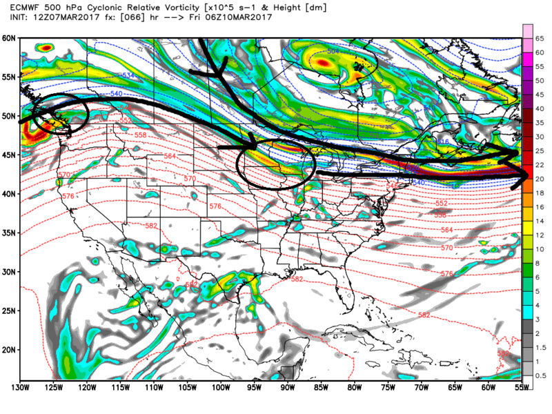

The second question is if a surface LP develops from an interaction where does it come off the coast? If it passes over or immediately just S of LI then temp issues esp from the surface to about 925mb may be an issue with a SW flow out ahead until the LP pulls east and the winds can swing around to NW. However as long as it passes S of LI, but not too far south, temps should not be much of an issue. The more interaction between the N and the Pac branches the better chance we have to have the mean trough dig just enough to force it into the Ohio Valey and consequently the surface LP move through the area on a slightly more W/SW to E/NE trajectory and the better the baroclinically enhanced lift we will see. If there is little to no interactions and the energy remains more strung out and QPF is light, boundary layer temps then will be an issue, QPF light, and the LP trajectory will be more NW/W to SE/E which will not yield much in the way of accumulation. Dew points look to be in the twenties. This appears pretty unified among models, so if the QPF is there the column will cool quickly and accumulations will occur even if its during daytime hours. The 850mb temps look to be -5 to -9 throughout at least that's how it seems modeled right now. Bottom line is we need to see some interactions with the two branches over or around the Ohio valley area to get accumulations. The good news is is the trend on the euro since 12z Yesterday is to have some form of interaction, and the GFS and NAM, and CMC, also have some form of interaction. With that said......
(For you weather mom)
WE TRACK!!!!

Last edited by sroc4 on Tue Mar 07, 2017 5:02 pm; edited 2 times in total
_________________
"In weather and in life, there's no winning and losing; there's only winning and learning."
WINTER 2012/2013 TOTALS 43.65"WINTER 2017/2018 TOTALS 62.85" WINTER 2022/2023 TOTALS 4.9"
WINTER 2013/2014 TOTALS 64.85"WINTER 2018/2019 TOTALS 14.25" WINTER 2023/2024 TOTALS 13.1"
WINTER 2014/2015 TOTALS 71.20"WINTER 2019/2020 TOTALS 6.35"
WINTER 2015/2016 TOTALS 35.00"WINTER 2020/2021 TOTALS 37.75"
WINTER 2016/2017 TOTALS 42.25"WINTER 2021/2022 TOTALS 31.65"

sroc4- Admin
- Posts : 8331
Reputation : 301
Join date : 2013-01-07
Location : Wading River, LI
Re: Friday, March 10th "Wave 1" Minor Snow Event
![]() by mikeypizano Tue Mar 07, 2017 3:51 pm
by mikeypizano Tue Mar 07, 2017 3:51 pm

mikeypizano- Pro Enthusiast

- Posts : 1118
Reputation : 66
Join date : 2017-01-05
Age : 35
Location : Wilkes-Barre/Scranton, PA
Re: Friday, March 10th "Wave 1" Minor Snow Event
![]() by sroc4 Tue Mar 07, 2017 3:55 pm
by sroc4 Tue Mar 07, 2017 3:55 pm
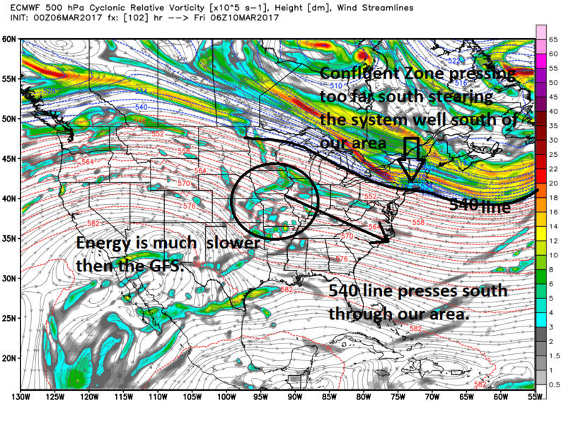
Frank_Wx wrote:UKMET for Wave 1 has .75" for NYC. That is 3-6" of snow.
You can see the branches are trying to interact. This is key. I don't have the next frame

_________________
"In weather and in life, there's no winning and losing; there's only winning and learning."
WINTER 2012/2013 TOTALS 43.65"WINTER 2017/2018 TOTALS 62.85" WINTER 2022/2023 TOTALS 4.9"
WINTER 2013/2014 TOTALS 64.85"WINTER 2018/2019 TOTALS 14.25" WINTER 2023/2024 TOTALS 13.1"
WINTER 2014/2015 TOTALS 71.20"WINTER 2019/2020 TOTALS 6.35"
WINTER 2015/2016 TOTALS 35.00"WINTER 2020/2021 TOTALS 37.75"
WINTER 2016/2017 TOTALS 42.25"WINTER 2021/2022 TOTALS 31.65"
sroc4- Admin
- Posts : 8331
Reputation : 301
Join date : 2013-01-07
Location : Wading River, LI
Re: Friday, March 10th "Wave 1" Minor Snow Event
![]() by Math23x7 Tue Mar 07, 2017 3:56 pm
by Math23x7 Tue Mar 07, 2017 3:56 pm
Math23x7- Wx Statistician Guru
- Posts : 2379
Reputation : 68
Join date : 2013-01-08

Snow88- Senior Enthusiast
- Posts : 2193
Reputation : 4
Join date : 2013-01-09
Age : 35
Location : Brooklyn, NY
Re: Friday, March 10th "Wave 1" Minor Snow Event
![]() by weatherwatchermom Tue Mar 07, 2017 4:47 pm
by weatherwatchermom Tue Mar 07, 2017 4:47 pm
mikeypizano wrote:So is this a maddone yet? Do I need to go pull the Toro outta the shed?
NOOOOOOOOOOOOOO NOT UNTIL THE LAST MINUTE....THIS IS PJ INSIDE OUT time... A NO CHANGES MOMENT!!
Last edited by weatherwatchermom on Tue Mar 07, 2017 4:57 pm; edited 1 time in total

weatherwatchermom- Senior Enthusiast
- Posts : 3734
Reputation : 77
Join date : 2014-11-25
Age : 60
Location : Hazlet Township, NJ
Re: Friday, March 10th "Wave 1" Minor Snow Event
![]() by Frank_Wx Tue Mar 07, 2017 4:55 pm
by Frank_Wx Tue Mar 07, 2017 4:55 pm
_________________
_______________________________________________________________________________________________________
CLICK HERE to view NJ Strong Snowstorm Classifications
Frank_Wx- Godzilla Seeker
- Posts : 21305
Reputation : 328
Join date : 2013-01-05
Age : 31
Location : Jersey City, NJ -
Re: Friday, March 10th "Wave 1" Minor Snow Event
![]() by dkodgis Tue Mar 07, 2017 5:00 pm
by dkodgis Tue Mar 07, 2017 5:00 pm
dkodgis- Senior Enthusiast
- Posts : 2493
Reputation : 98
Join date : 2013-12-29
Re: Friday, March 10th "Wave 1" Minor Snow Event
![]() by sroc4 Tue Mar 07, 2017 5:11 pm
by sroc4 Tue Mar 07, 2017 5:11 pm
Frank_Wx wrote:Latest 18z gfs looks weaker and quite warm at the surface with Wave 1. I have a feeling we're far from the final solution, but I would put us in the C-2" range at this juncture
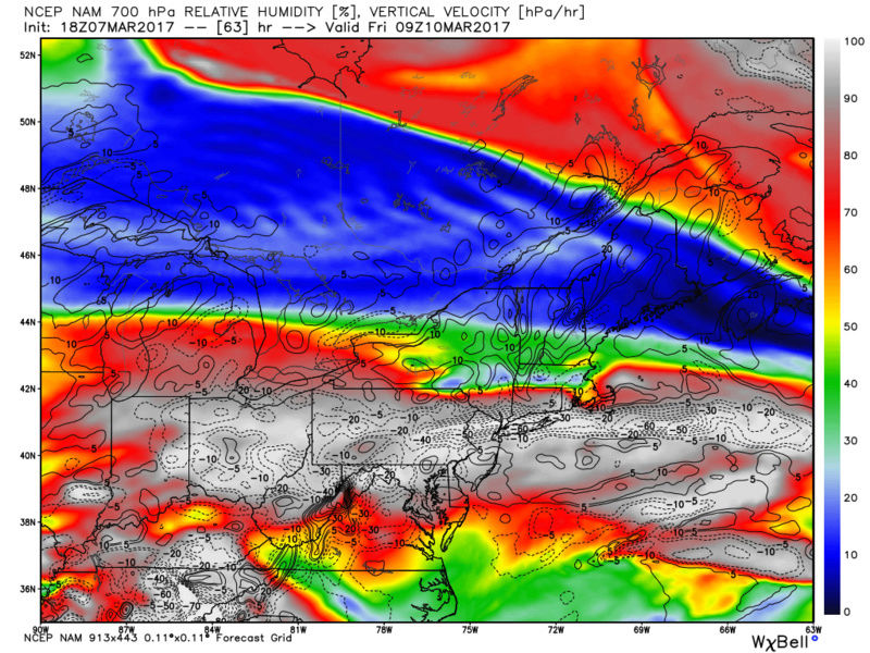
Honestly the 18z GFS isn't exactly the go to model for surface temps and dew points. And if you look 925mbstarts at -2 to -3 and 850 at -3 to -4 at the start of precip with a surface temp of 40 but temps are crashing fast. Almost time for the hi res to take over. VV on the NAM look impressive for a period of time; granted its a narrow band. We are def far from a soln.
_________________
"In weather and in life, there's no winning and losing; there's only winning and learning."
WINTER 2012/2013 TOTALS 43.65"WINTER 2017/2018 TOTALS 62.85" WINTER 2022/2023 TOTALS 4.9"
WINTER 2013/2014 TOTALS 64.85"WINTER 2018/2019 TOTALS 14.25" WINTER 2023/2024 TOTALS 13.1"
WINTER 2014/2015 TOTALS 71.20"WINTER 2019/2020 TOTALS 6.35"
WINTER 2015/2016 TOTALS 35.00"WINTER 2020/2021 TOTALS 37.75"
WINTER 2016/2017 TOTALS 42.25"WINTER 2021/2022 TOTALS 31.65"
sroc4- Admin
- Posts : 8331
Reputation : 301
Join date : 2013-01-07
Location : Wading River, LI
Re: Friday, March 10th "Wave 1" Minor Snow Event
![]() by Guest Tue Mar 07, 2017 5:22 pm
by Guest Tue Mar 07, 2017 5:22 pm
Snow88 wrote:Nam is good for NYC south
Para Nam is good for NYC north
Can anyone say Long Island Bullseye!!
Guest- Guest
Re: Friday, March 10th "Wave 1" Minor Snow Event
![]() by mikeypizano Tue Mar 07, 2017 5:26 pm
by mikeypizano Tue Mar 07, 2017 5:26 pm
weatherwatchermom wrote:mikeypizano wrote:So is this a maddone yet? Do I need to go pull the Toro outta the shed?
NOOOOOOOOOOOOOO NOT UNTIL THE LAST MINUTE....THIS IS PJ INSIDE OUT time... A NO CHANGES MOMENT!!
Nope, have to have it ready and fueled up in advance when you have 20 driveways or so to do (depending on who calls) and start at FIVE AM
mikeypizano- Pro Enthusiast
- Posts : 1118
Reputation : 66
Join date : 2017-01-05
Age : 35
Location : Wilkes-Barre/Scranton, PA
Re: Friday, March 10th "Wave 1" Minor Snow Event
![]() by weatherwatchermom Tue Mar 07, 2017 5:45 pm
by weatherwatchermom Tue Mar 07, 2017 5:45 pm
mikeypizano wrote:weatherwatchermom wrote:mikeypizano wrote:So is this a maddone yet? Do I need to go pull the Toro outta the shed?
NOOOOOOOOOOOOOO NOT UNTIL THE LAST MINUTE....THIS IS PJ INSIDE OUT time... A NO CHANGES MOMENT!!
Nope, have to have it ready and fueled up in advance when you have 20 driveways or so to do (depending on who calls) and start at FIVE AM
I can completely understand that...was only playing with you!!
weatherwatchermom- Senior Enthusiast
- Posts : 3734
Reputation : 77
Join date : 2014-11-25
Age : 60
Location : Hazlet Township, NJ
Re: Friday, March 10th "Wave 1" Minor Snow Event
![]() by SoulSingMG Tue Mar 07, 2017 5:51 pm
by SoulSingMG Tue Mar 07, 2017 5:51 pm

SoulSingMG- Senior Enthusiast
- Posts : 2853
Reputation : 74
Join date : 2013-12-11
Location : Long Island City, NY
Re: Friday, March 10th "Wave 1" Minor Snow Event
![]() by mikeypizano Tue Mar 07, 2017 6:03 pm
by mikeypizano Tue Mar 07, 2017 6:03 pm

mikeypizano- Pro Enthusiast
- Posts : 1118
Reputation : 66
Join date : 2017-01-05
Age : 35
Location : Wilkes-Barre/Scranton, PA
Re: Friday, March 10th "Wave 1" Minor Snow Event
![]() by Armando Salvadore Tue Mar 07, 2017 6:26 pm
by Armando Salvadore Tue Mar 07, 2017 6:26 pm

Armando Salvadore- Advanced Forecaster

- Posts : 171
Reputation : 0
Join date : 2016-12-23
Location : Springfield, NJ
Re: Friday, March 10th "Wave 1" Minor Snow Event
![]() by Math23x7 Tue Mar 07, 2017 6:27 pm
by Math23x7 Tue Mar 07, 2017 6:27 pm
PS: Tom (NjWeatherGuy), where are you? I would love to hear your insight regarding the next week.
Math23x7- Wx Statistician Guru
- Posts : 2379
Reputation : 68
Join date : 2013-01-08
Re: Friday, March 10th "Wave 1" Minor Snow Event
![]() by amugs Tue Mar 07, 2017 6:53 pm
by amugs Tue Mar 07, 2017 6:53 pm
Math23x7 wrote:18Z GFS looked nice but still concerned about the March sun.
PS: Tom (NjWeatherGuy), where are you? I would love to hear your insight regarding the next week.
Mike it comes at night 1-2 am till 11am ish - no worries unless something changes with the sun that is
@ SROC - got ya - thought she was coming straight out of the arctic thru Alberta and diving down
GEFS say 18Z hogwash!!

_________________
Mugs
AKA:King: Snow Weenie
Self Proclaimed
WINTER 2014-15 : 55.12" +.02 for 6 coatings (avg. 35")
WINTER 2015-16 Total - 29.8" (Avg 35")
WINTER 2016-17 : 39.5" so far

amugs- Advanced Forecaster - Mod
- Posts : 15093
Reputation : 213
Join date : 2013-01-07
Age : 54
Location : Hillsdale,NJ
Re: Friday, March 10th "Wave 1" Minor Snow Event
![]() by mmanisca Tue Mar 07, 2017 7:35 pm
by mmanisca Tue Mar 07, 2017 7:35 pm

mmanisca- Pro Enthusiast
- Posts : 298
Reputation : 3
Join date : 2013-01-23
Age : 65
Location : Deer Park, Long Island
Re: Friday, March 10th "Wave 1" Minor Snow Event
![]() by sroc4 Tue Mar 07, 2017 10:18 pm
by sroc4 Tue Mar 07, 2017 10:18 pm
_________________
"In weather and in life, there's no winning and losing; there's only winning and learning."
WINTER 2012/2013 TOTALS 43.65"WINTER 2017/2018 TOTALS 62.85" WINTER 2022/2023 TOTALS 4.9"
WINTER 2013/2014 TOTALS 64.85"WINTER 2018/2019 TOTALS 14.25" WINTER 2023/2024 TOTALS 13.1"
WINTER 2014/2015 TOTALS 71.20"WINTER 2019/2020 TOTALS 6.35"
WINTER 2015/2016 TOTALS 35.00"WINTER 2020/2021 TOTALS 37.75"
WINTER 2016/2017 TOTALS 42.25"WINTER 2021/2022 TOTALS 31.65"
sroc4- Admin
- Posts : 8331
Reputation : 301
Join date : 2013-01-07
Location : Wading River, LI
Page 4 of 8 • 1, 2, 3, 4, 5, 6, 7, 8 ![]()
|
|
|