
 Search
March 14, 2017 Roidzilla 1st Call Snow Map / Synopsis
Page 20 of 33 •  1 ... 11 ... 19, 20, 21 ... 26 ... 33
 ![]()
Re: March 14, 2017 Roidzilla 1st Call Snow Map / Synopsis
![]() by jmanley32 Mon Mar 13, 2017 11:11 am
by jmanley32 Mon Mar 13, 2017 11:11 am
jmanley32- Senior Enthusiast

- Posts : 20513
Join date : 2013-12-12
Re: March 14, 2017 Roidzilla 1st Call Snow Map / Synopsis
![]() by jake732 Mon Mar 13, 2017 11:12 am
by jake732 Mon Mar 13, 2017 11:12 am
jake732- Pro Enthusiast

- Posts : 449
Join date : 2016-01-03 -

Re: March 14, 2017 Roidzilla 1st Call Snow Map / Synopsis
![]() by Snow88 Mon Mar 13, 2017 11:12 am
by Snow88 Mon Mar 13, 2017 11:12 am
Looks like it changes to rain at the end after a good dumping of snow

Snow88- Senior Enthusiast
- Posts : 2193
Reputation : 4
Join date : 2013-01-09
Age : 35
Location : Brooklyn, NY
Re: March 14, 2017 Roidzilla 1st Call Snow Map / Synopsis
![]() by Frank_Wx Mon Mar 13, 2017 11:13 am
by Frank_Wx Mon Mar 13, 2017 11:13 am

_________________
_______________________________________________________________________________________________________
CLICK HERE to view NJ Strong Snowstorm Classifications

Frank_Wx- Godzilla Seeker

- Posts : 21305
Reputation : 328
Join date : 2013-01-05
Age : 31
Location : Jersey City, NJ -
Re: March 14, 2017 Roidzilla 1st Call Snow Map / Synopsis
![]() by Frank_Wx Mon Mar 13, 2017 11:14 am
by Frank_Wx Mon Mar 13, 2017 11:14 am
_________________
_______________________________________________________________________________________________________
CLICK HERE to view NJ Strong Snowstorm Classifications
Frank_Wx- Godzilla Seeker
- Posts : 21305
Reputation : 328
Join date : 2013-01-05
Age : 31
Location : Jersey City, NJ -
Re: March 14, 2017 Roidzilla 1st Call Snow Map / Synopsis
![]() by jmanley32 Mon Mar 13, 2017 11:19 am
by jmanley32 Mon Mar 13, 2017 11:19 am

jmanley32- Senior Enthusiast
- Posts : 20513
Reputation : 108
Join date : 2013-12-12
Age : 42
Location : Yonkers, NY
Re: March 14, 2017 Roidzilla 1st Call Snow Map / Synopsis
![]() by Snow88 Mon Mar 13, 2017 11:19 am
by Snow88 Mon Mar 13, 2017 11:19 am
Snow88- Senior Enthusiast
- Posts : 2193
Reputation : 4
Join date : 2013-01-09
Age : 35
Location : Brooklyn, NY
Re: March 14, 2017 Roidzilla 1st Call Snow Map / Synopsis
![]() by Frank_Wx Mon Mar 13, 2017 11:21 am
by Frank_Wx Mon Mar 13, 2017 11:21 am

_________________
_______________________________________________________________________________________________________
CLICK HERE to view NJ Strong Snowstorm Classifications
Frank_Wx- Godzilla Seeker
- Posts : 21305
Reputation : 328
Join date : 2013-01-05
Age : 31
Location : Jersey City, NJ -
Re: March 14, 2017 Roidzilla 1st Call Snow Map / Synopsis
![]() by SoulSingMG Mon Mar 13, 2017 11:22 am
by SoulSingMG Mon Mar 13, 2017 11:22 am
Frank_Wx wrote:
This has my full snowfall endorsement. ;-)

SoulSingMG- Senior Enthusiast
- Posts : 2853
Reputation : 74
Join date : 2013-12-11
Location : Long Island City, NY
Re: March 14, 2017 Roidzilla 1st Call Snow Map / Synopsis
![]() by SoulSingMG Mon Mar 13, 2017 11:24 am
by SoulSingMG Mon Mar 13, 2017 11:24 am
SoulSingMG- Senior Enthusiast
- Posts : 2853
Reputation : 74
Join date : 2013-12-11
Location : Long Island City, NY
Re: March 14, 2017 Roidzilla 1st Call Snow Map / Synopsis
![]() by billg315 Mon Mar 13, 2017 11:24 am
by billg315 Mon Mar 13, 2017 11:24 am
Snow should begin falling in central and northern New Jersey between midnight and 3 a.m. and will quickly pick up in intensity by 5 or 6 a.m. The snow will become heavy at times by daybreak and will be accompanied by strong gusty east/northeast winds. At times in the middle of tomorrow morning we may have snowfall rates of 2-3” per hour (or a bit more) with 20-30 mph winds and gusts over 40 mph. Further east winds may top 30 mph sustained with gusts to near 60 mph. These winds combined with prodigious snowfall rates will create virtual “whiteout” conditions at times tomorrow morning. The snow will continue into the afternoon.
There are two key variables in terms of snowfall amounts and storm duration. One is the speed of the storm. Originally this storm was modeled to last until after midnight Tuesday into Wednesday morning. Some models still hint at this longer duration. BUT . . . my experience is these storms accelerate and move quickly up the coast. I believe the models currently showing the snow ending by mid-to-late afternoon tomorrow are accurate. This doesn’t mean some snow showers or squalls couldn’t affect the area in the evening and overnight tomorrow night, but the MAIN area of snow should start to wind down during the afternoon hours. With the winds behind this system there will be considerable blowing and drifting of snow during the storm and after the storm into Wednesday morning. Another factor is that this storm will likely hug tight to the coast. Just how tight will determine whether rain mixes in at the Jersey Shore and whether sleet mixes in here. A couple hours of sleet mixing in will suppress totals. I think some mixing is possible even in interior NJ, even though this will be mainly a snow event. At the Jersey Shore I think there will be a lot of sleet and maybe some rain which will keep totals somewhat in check there.
Considering these variables here are the amounts I expect:
Central New Jersey (including Somerville) roughly from I-195 north to I-80: generally 10”-15” with isolated amounts of 16-20” in areas of heavier banding.
Northwest New Jersey (Warren and Sussex) and north of I-80 into the Hudson Valley: generally 15”-20” with isolated 20-24” spots.
Jersey Shore (Monmouth and Ocean): generally 6”-10” with sleet and rain likely to mix in. Similar situation on Long Island I think.
Just my thoughts.
Last edited by billg315 on Mon Mar 13, 2017 11:27 am; edited 1 time in total

billg315- Advanced Forecaster - Mod

- Posts : 4462
Reputation : 185
Join date : 2015-01-24
Age : 50
Location : Flemington, NJ
Re: March 14, 2017 Roidzilla 1st Call Snow Map / Synopsis
![]() by Guest Mon Mar 13, 2017 11:25 am
by Guest Mon Mar 13, 2017 11:25 am
Snow88 wrote:RPM shows over 15 inches for NYC west and 12 inches east of there
No sarcasm here. As much as this sucks to say congratulations to all you N and w folks.
 You deserve it. As far as LI goes a full week of hype and tracking looks to bring me my 3rd largest storm of this winter.
  Sucks. Huge letdown when I was looking at a hecs/becs 2 days ago. Enjoy!!
NAM was right all along.
Guest- Guest
Re: March 14, 2017 Roidzilla 1st Call Snow Map / Synopsis
![]() by RJB8525 Mon Mar 13, 2017 11:25 am
by RJB8525 Mon Mar 13, 2017 11:25 am

RJB8525- Senior Enthusiast
- Posts : 1994
Reputation : 28
Join date : 2013-02-06
Age : 38
Location : Hackettstown, NJ
Re: March 14, 2017 Roidzilla 1st Call Snow Map / Synopsis
![]() by SNOW MAN Mon Mar 13, 2017 11:27 am
by SNOW MAN Mon Mar 13, 2017 11:27 am

SNOW MAN- Senior Enthusiast
- Posts : 1361
Reputation : 25
Join date : 2013-01-13
Age : 64
Location : Marshalls Creek Pa.
Re: March 14, 2017 Roidzilla 1st Call Snow Map / Synopsis
![]() by CPcantmeasuresnow Mon Mar 13, 2017 11:27 am
by CPcantmeasuresnow Mon Mar 13, 2017 11:27 am
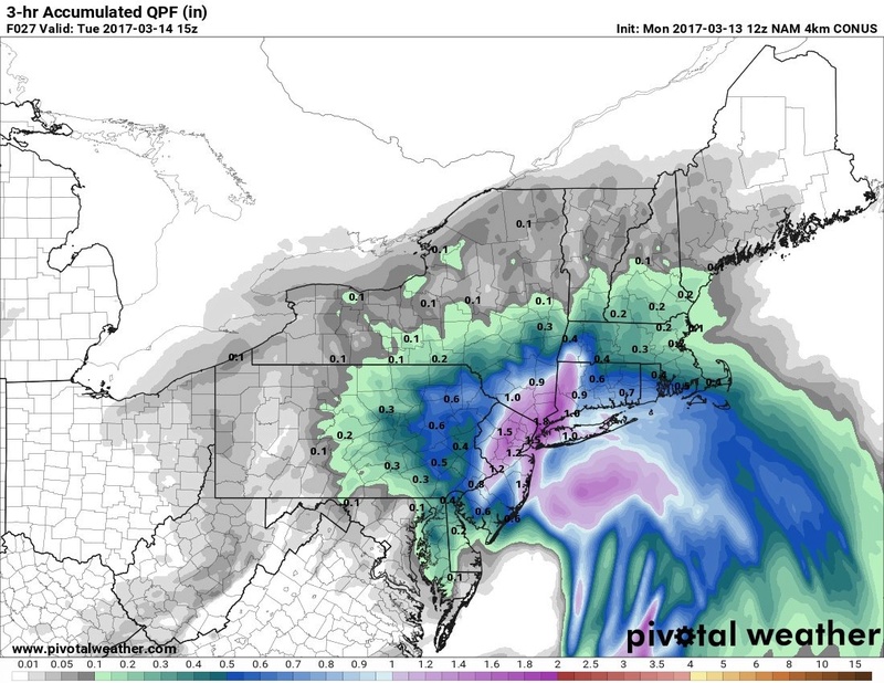
SoulSingMG wrote:God Almighty... this QPF is in a 3 HOUR stretch!
And this is why someone in our area will most likely get a foot or more of snow in a 3 hour period.
Look at the time and I've done nothing today or for the past 5 days really. Sad but no cure, I try.

CPcantmeasuresnow- Wx Statistician Guru

- Posts : 7274
Reputation : 230
Join date : 2013-01-07
Age : 103
Location : Eastern Orange County, NY
Re: March 14, 2017 Roidzilla 1st Call Snow Map / Synopsis
![]() by jmanley32 Mon Mar 13, 2017 11:34 am
by jmanley32 Mon Mar 13, 2017 11:34 am
No fin way 16 inches imby in 3 to 5 hrs omg im.get a full on blizzard suit today that's go.b insane!!!SoulSingMG wrote:God Almighty... this QPF is in a 3 HOUR stretch!
Last edited by jmanley32 on Mon Mar 13, 2017 11:37 am; edited 1 time in total
jmanley32- Senior Enthusiast
- Posts : 20513
Reputation : 108
Join date : 2013-12-12
Age : 42
Location : Yonkers, NY
Re: March 14, 2017 Roidzilla 1st Call Snow Map / Synopsis
![]() by SoulSingMG Mon Mar 13, 2017 11:35 am
by SoulSingMG Mon Mar 13, 2017 11:35 am
CPcantmeasuresnow wrote:SoulSingMG wrote:God Almighty... this QPF is in a 3 HOUR stretch!
And this is why someone in our area will most likely get a foot or more of snow in a 3 hour period.
Look at the time and I've done nothing today or for the past 5 days really. Sad but no cure, I try.
I was JUST thinking the same CP hahaha. What are we gonna do after the storm? I'll be going thru postpartum but maybe I'll actually get something done...?
SoulSingMG- Senior Enthusiast
- Posts : 2853
Reputation : 74
Join date : 2013-12-11
Location : Long Island City, NY
Re: March 14, 2017 Roidzilla 1st Call Snow Map / Synopsis
![]() by Snow88 Mon Mar 13, 2017 11:37 am
by Snow88 Mon Mar 13, 2017 11:37 am
GFS shifted slightly east and has a huge hit for the area
Snowmaps coming soon
Snow88- Senior Enthusiast
- Posts : 2193
Reputation : 4
Join date : 2013-01-09
Age : 35
Location : Brooklyn, NY
Re: March 14, 2017 Roidzilla 1st Call Snow Map / Synopsis
![]() by jmanley32 Mon Mar 13, 2017 11:39 am
by jmanley32 Mon Mar 13, 2017 11:39 am
jmanley32- Senior Enthusiast
- Posts : 20513
Reputation : 108
Join date : 2013-12-12
Age : 42
Location : Yonkers, NY
Re: March 14, 2017 Roidzilla 1st Call Snow Map / Synopsis
![]() by Aiosamoney21 Mon Mar 13, 2017 11:39 am
by Aiosamoney21 Mon Mar 13, 2017 11:39 am
Aiosamoney21- Posts : 86
Reputation : 1
Join date : 2014-02-09
Age : 32
Location : Norwood NJ
Re: March 14, 2017 Roidzilla 1st Call Snow Map / Synopsis
![]() by Snow88 Mon Mar 13, 2017 11:40 am
by Snow88 Mon Mar 13, 2017 11:40 am
Snow88- Senior Enthusiast
- Posts : 2193
Reputation : 4
Join date : 2013-01-09
Age : 35
Location : Brooklyn, NY

Sanchize06- Senior Enthusiast
- Posts : 1041
Reputation : 21
Join date : 2013-02-05
Location : Union Beach, NJ
Re: March 14, 2017 Roidzilla 1st Call Snow Map / Synopsis
![]() by deadrabbit79 Mon Mar 13, 2017 11:42 am
by deadrabbit79 Mon Mar 13, 2017 11:42 am
deadrabbit79- Posts : 176
Reputation : 6
Join date : 2013-01-25
Location : Hartsdale, New York
Re: March 14, 2017 Roidzilla 1st Call Snow Map / Synopsis
![]() by jmanley32 Mon Mar 13, 2017 11:42 am
by jmanley32 Mon Mar 13, 2017 11:42 am
jmanley32- Senior Enthusiast
- Posts : 20513
Reputation : 108
Join date : 2013-12-12
Age : 42
Location : Yonkers, NY
Re: March 14, 2017 Roidzilla 1st Call Snow Map / Synopsis
![]() by RJB8525 Mon Mar 13, 2017 11:44 am
by RJB8525 Mon Mar 13, 2017 11:44 am
RJB8525- Senior Enthusiast
- Posts : 1994
Reputation : 28
Join date : 2013-02-06
Age : 38
Location : Hackettstown, NJ
Re: March 14, 2017 Roidzilla 1st Call Snow Map / Synopsis
![]() by Aiosamoney21 Mon Mar 13, 2017 11:46 am
by Aiosamoney21 Mon Mar 13, 2017 11:46 am
Aiosamoney21- Posts : 86
Reputation : 1
Join date : 2014-02-09
Age : 32
Location : Norwood NJ
Re: March 14, 2017 Roidzilla 1st Call Snow Map / Synopsis
![]() by Aiosamoney21 Mon Mar 13, 2017 11:48 am
by Aiosamoney21 Mon Mar 13, 2017 11:48 am
Aiosamoney21- Posts : 86
Reputation : 1
Join date : 2014-02-09
Age : 32
Location : Norwood NJ
Page 20 of 33 • 1 ... 11 ... 19, 20, 21 ... 26 ... 33 ![]()
|
|
|