Possible Christmas Day Storm
+23
Dtone
Vinnydula
Dunnzoo
hyde345
bobjohnsonforthehall
jimv45
docstox12
weatherwatchermom
RJB8525
frank 638
Sanchize06
aiannone
Math23x7
CPcantmeasuresnow
amugs
Snow88
rb924119
jmanley32
track17
mmanisca
sroc4
mikeypizano
Frank_Wx
27 posters
Page 3 of 9 •  1, 2, 3, 4, 5, 6, 7, 8, 9
 Re: Possible Christmas Day Storm
Does anyone know how much snow we will have by Xmas morning
frank 638- Senior Enthusiast

- Posts : 2843
Join date : 2016-01-01
 Re: Possible Christmas Day Storm
My how things have changed earlier in the week just 3 days ago the forecast was for 53 and rain. 

Sunday NightRain and snow likely after 7pm, becoming all snow after 11pm. Mostly cloudy, with a low around 32. Chance of precipitation is 70%. New snow accumulation of 1 to 3 inches possible.
Christmas DayA 30 percent chance of snow. High 35
Sunday NightRain and snow likely after 7pm, becoming all snow after 11pm. Mostly cloudy, with a low around 32. Chance of precipitation is 70%. New snow accumulation of 1 to 3 inches possible.
Christmas DayA 30 percent chance of snow. High 35
Guest- Guest
 Re: Possible Christmas Day Storm
That's great syo can you push that magic to the jersey coast we are still looking at all rain
track17- Posts : 454
Reputation : 4
Join date : 2016-01-09
 Re: Possible Christmas Day Storm
between a tenth and quarter of an inch possible.
Sunday
Partly sunny, with a high near 41. North wind 3 to 7 mph.
Sunday Night
Snow likely, mainly after 1am. Mostly cloudy, with a low around 26. Chance of precipitation is 60%.
Christmas Day
Mostly sunny, with a high near 34.
Sunday
Partly sunny, with a high near 41. North wind 3 to 7 mph.
Sunday Night
Snow likely, mainly after 1am. Mostly cloudy, with a low around 26. Chance of precipitation is 60%.
Christmas Day
Mostly sunny, with a high near 34.

RJB8525- Senior Enthusiast

- Posts : 1994
Reputation : 28
Join date : 2013-02-06
Age : 38
Location : Hackettstown, NJ
 Re: Possible Christmas Day Storm
Anyway this can trend colder and bring the jersey coast some snow or will it be just rain like it is showing?
track17- Posts : 454
Reputation : 4
Join date : 2016-01-09
 Re: Possible Christmas Day Storm
track17 wrote:Anyway this can trend colder and bring the jersey coast some snow or will it be just rain like it is showing?
This will turn to snow for you to Track. I’m pretty confident. How old are you by the way?
Guest- Guest
 Re: Possible Christmas Day Storm
Jimmy I actually agree with you. I am willing to bet we see surprises. From NYC and points east on LI if you live N of the LIE you have a chance for surprise snowfall accumulations. It will me light, but it might occur. There is also the possibility of IVT type enhanced mesoscale convective bands set up somewhere in the area. This may occur to our N somewhere over Ct, but these features are tough to predict.
The key will be when does the wind shift at the surface relative to the precip. Look at the GFS for when the precip moves in compared to the temp profiles.


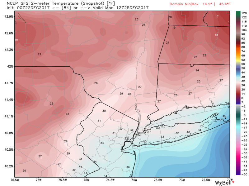
At the onset surface temps are way to warm along the coast, but Look at where the temps are just to the N of the LI Sound. They are very cold. Now notice how fast temps drop in a 6 hr period. As the low passes S of LI the wind direction will be E off the warmer ocean, but as it passes E and centers itself just E of Cape Cod the wind direction should swing around to NE and N. As it does it will immediately usher in that very cold air mass just to the N. They key will be how fast does it happen, and where is the precip when it does.
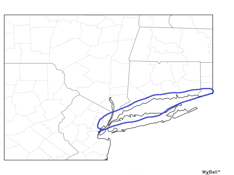
Global models do not have the resolution to see this potential with the temp drops. The strength of the max is still trending and only slight shifts, 25-50 miles N or S as it swings through and how strong it is important because these features will dictate surface wind direction and timing of such. This is why additional trends are still likely coming as there are still differences. The area I have circled have the best chance for surprise accumulations IMO. The twin forks and S half of LI I think will still struggle.
The key will be when does the wind shift at the surface relative to the precip. Look at the GFS for when the precip moves in compared to the temp profiles.


At the onset surface temps are way to warm along the coast, but Look at where the temps are just to the N of the LI Sound. They are very cold. Now notice how fast temps drop in a 6 hr period. As the low passes S of LI the wind direction will be E off the warmer ocean, but as it passes E and centers itself just E of Cape Cod the wind direction should swing around to NE and N. As it does it will immediately usher in that very cold air mass just to the N. They key will be how fast does it happen, and where is the precip when it does.
Global models do not have the resolution to see this potential with the temp drops. The strength of the max is still trending and only slight shifts, 25-50 miles N or S as it swings through and how strong it is important because these features will dictate surface wind direction and timing of such. This is why additional trends are still likely coming as there are still differences. The area I have circled have the best chance for surprise accumulations IMO. The twin forks and S half of LI I think will still struggle.

_________________
"In weather and in life, there's no winning and losing; there's only winning and learning."
WINTER 2012/2013 TOTALS 43.65"WINTER 2017/2018 TOTALS 62.85" WINTER 2022/2023 TOTALS 4.9"
WINTER 2013/2014 TOTALS 64.85"WINTER 2018/2019 TOTALS 14.25" WINTER 2023/2024 TOTALS 13.1"
WINTER 2014/2015 TOTALS 71.20"WINTER 2019/2020 TOTALS 6.35"
WINTER 2015/2016 TOTALS 35.00"WINTER 2020/2021 TOTALS 37.75"
WINTER 2016/2017 TOTALS 42.25"WINTER 2021/2022 TOTALS 31.65"

sroc4- Admin

- Posts : 8354
Reputation : 302
Join date : 2013-01-07
Location : Wading River, LI
 Re: Possible Christmas Day Storm
So Sroc you think there is no chance for the jersey coast then. Is there a chance of it being nothing then because I would rather nothing then rain
track17- Posts : 454
Reputation : 4
Join date : 2016-01-09
 Re: Possible Christmas Day Storm
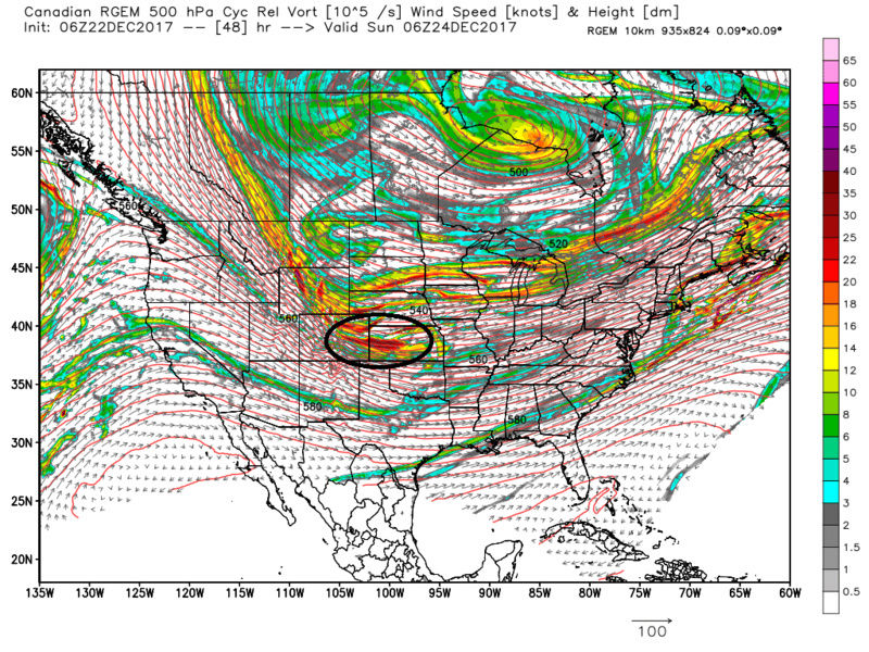
The RGEM cont to come in with a stronger vort max when compared to the global models. This has been the trend all season thus far: stronger vort max trend inside 48hrs. The stronger the 500mb vorticity the stronger the lifting mechanisms as it swings over head.


_________________
"In weather and in life, there's no winning and losing; there's only winning and learning."
WINTER 2012/2013 TOTALS 43.65"WINTER 2017/2018 TOTALS 62.85" WINTER 2022/2023 TOTALS 4.9"
WINTER 2013/2014 TOTALS 64.85"WINTER 2018/2019 TOTALS 14.25" WINTER 2023/2024 TOTALS 13.1"
WINTER 2014/2015 TOTALS 71.20"WINTER 2019/2020 TOTALS 6.35"
WINTER 2015/2016 TOTALS 35.00"WINTER 2020/2021 TOTALS 37.75"
WINTER 2016/2017 TOTALS 42.25"WINTER 2021/2022 TOTALS 31.65"

sroc4- Admin

- Posts : 8354
Reputation : 302
Join date : 2013-01-07
Location : Wading River, LI
 Re: Possible Christmas Day Storm
track17 wrote:So Sroc you think there is no chance for the jersey coast then. Is there a chance of it being nothing then because I would rather nothing then rain
I think the immediate Jersey coast will struggle mightily for an accumulation, but there may be a period of "white Rain". Surface temps wont allow accumulations but the rest of the atmosphere will be cold enough to support snow as the low departs.
_________________
"In weather and in life, there's no winning and losing; there's only winning and learning."
WINTER 2012/2013 TOTALS 43.65"WINTER 2017/2018 TOTALS 62.85" WINTER 2022/2023 TOTALS 4.9"
WINTER 2013/2014 TOTALS 64.85"WINTER 2018/2019 TOTALS 14.25" WINTER 2023/2024 TOTALS 13.1"
WINTER 2014/2015 TOTALS 71.20"WINTER 2019/2020 TOTALS 6.35"
WINTER 2015/2016 TOTALS 35.00"WINTER 2020/2021 TOTALS 37.75"
WINTER 2016/2017 TOTALS 42.25"WINTER 2021/2022 TOTALS 31.65"

sroc4- Admin

- Posts : 8354
Reputation : 302
Join date : 2013-01-07
Location : Wading River, LI
 Re: Possible Christmas Day Storm
Thank you Sroc for being honest and not getting my hopes up with this.
track17- Posts : 454
Reputation : 4
Join date : 2016-01-09
 Re: Possible Christmas Day Storm
sroc4 wrote:track17 wrote:So Sroc you think there is no chance for the jersey coast then. Is there a chance of it being nothing then because I would rather nothing then rain
I think the immediate Jersey coast will struggle mightily for an accumulation, but there may be a period of "white Rain". Surface temps wont allow accumulations but the rest of the atmosphere will be cold enough to support snow as the low departs.
You have been amazing right from the beginning with this one Scott. Al, RB and Frank and mugs also saw this one coming four days before the pros. Even if it doesn't snow just the fact that it will be in the 30s on Christmas day and not the 50s or even 60s like some warmists (torch mongerers) were predicting a week ago is a huge victory.
1 to 3 inches of snow would be a nice touch for Christmas morning, that's all I'm hoping for and if I get it great, but like I said whether we do or don't just the fact that you guys were on top of this when everyone else wasn't is another feather in your caps.

CPcantmeasuresnow- Wx Statistician Guru

- Posts : 7274
Reputation : 230
Join date : 2013-01-07
Age : 103
Location : Eastern Orange County, NY
 Re: Possible Christmas Day Storm
track17 wrote:34 why syo
Just curious buddy. Enjoy the holidays
Guest- Guest
 Re: Possible Christmas Day Storm
Thanks syo same to you. You do a great job I hope your correct and I see some snow Sroc did not sound confident but your analysis is always great too
track17- Posts : 454
Reputation : 4
Join date : 2016-01-09
 Re: Possible Christmas Day Storm
CPcantmeasuresnow wrote:sroc4 wrote:track17 wrote:So Sroc you think there is no chance for the jersey coast then. Is there a chance of it being nothing then because I would rather nothing then rain
I think the immediate Jersey coast will struggle mightily for an accumulation, but there may be a period of "white Rain". Surface temps wont allow accumulations but the rest of the atmosphere will be cold enough to support snow as the low departs.
You have been amazing right from the beginning with this one Scott. Al, RB and Frank and mugs also saw this one coming four days before the pros. Even if it doesn't snow just the fact that it will be in the 30s on Christmas day and not the 50s or even 60s like some warmists (torch mongerers) were predicting a week ago is a huge victory.
1 to 3 inches of snow would be a nice touch for Christmas morning, that's all I'm hoping for and if I get it great, but like I said whether we do or don't just the fact that you guys were on top of this when everyone else wasn't is another feather in your caps.
Thank You CP. I really appreciate that.
_________________
"In weather and in life, there's no winning and losing; there's only winning and learning."
WINTER 2012/2013 TOTALS 43.65"WINTER 2017/2018 TOTALS 62.85" WINTER 2022/2023 TOTALS 4.9"
WINTER 2013/2014 TOTALS 64.85"WINTER 2018/2019 TOTALS 14.25" WINTER 2023/2024 TOTALS 13.1"
WINTER 2014/2015 TOTALS 71.20"WINTER 2019/2020 TOTALS 6.35"
WINTER 2015/2016 TOTALS 35.00"WINTER 2020/2021 TOTALS 37.75"
WINTER 2016/2017 TOTALS 42.25"WINTER 2021/2022 TOTALS 31.65"

sroc4- Admin

- Posts : 8354
Reputation : 302
Join date : 2013-01-07
Location : Wading River, LI
 Re: Possible Christmas Day Storm
I will be just happy to see snow flakes on Christmas...my son just turned 13 and I don't recall us every having any flakes fall on the 25th..so even if a flurry or two he will be excited..we talked about the possibility of it happening last night...We did have that storm in 2010 but that was the 26th... Math you can correct me if I am wrong...I just do not recall..  MERRY CHRISTMAS and AS ALWAYS YOU ALL DO SUCH A GREAT JOB!!

weatherwatchermom- Senior Enthusiast

- Posts : 3793
Reputation : 78
Join date : 2014-11-25
Location : Hazlet Township, NJ
 Re: Possible Christmas Day Storm
Nam is further west with rain to snow for the coast and snow inland

Snow88- Senior Enthusiast

- Posts : 2193
Reputation : 4
Join date : 2013-01-09
Age : 35
Location : Brooklyn, NY
 Re: Possible Christmas Day Storm
Looks like I pick up 2 inches in the NAM

mikeypizano- Pro Enthusiast

- Posts : 1118
Reputation : 66
Join date : 2017-01-05
Age : 35
Location : Wilkes-Barre/Scranton, PA
 Re: Possible Christmas Day Storm
Damm this just gets worse with each run. How far west? Not good at all
track17- Posts : 454
Reputation : 4
Join date : 2016-01-09
 Re: Possible Christmas Day Storm
Both places I'm gonna be for the holidays are in your circle sroc win win!

jmanley32- Senior Enthusiast

- Posts : 20535
Reputation : 108
Join date : 2013-12-12
Age : 43
Location : Yonkers, NY
 Re: Possible Christmas Day Storm
The long range crew brought it home! Cold with 1 to 3 inches for a White Christmas!!!! Frank, Doc, rb Mugs......amazing job!!!

docstox12- Wx Statistician Guru

- Posts : 8530
Reputation : 222
Join date : 2013-01-07
Age : 73
Location : Monroe NY
 Re: Possible Christmas Day Storm
track17 wrote:Damm this just gets worse with each run. How far west? Not good at all
Track you gotta relax. Nothing has changed for the worse. Wetter means more qpf. West is not necessarily bad depending on the strength
Guest- Guest
 Re: Possible Christmas Day Storm
Sroc said earlier it did bud for us at least. It is ok though just wish nothing would come rather then rain. Rain does not feel like christmas
track17- Posts : 454
Reputation : 4
Join date : 2016-01-09
 Re: Possible Christmas Day Storm
Rain to snow theme continues on the GFS


_________________
_______________________________________________________________________________________________________
CLICK HERE to view NJ Strong Snowstorm Classifications
 Re: Possible Christmas Day Storm
NAM is colder than GFS. C-2" with 3-4" amounts N&W of NYC is my call for this system


_________________
_______________________________________________________________________________________________________
CLICK HERE to view NJ Strong Snowstorm Classifications
 Re: Possible Christmas Day Storm
track17 wrote:Sroc said earlier it did bud for us at least. It is ok though just wish nothing would come rather then rain. Rain does not feel like christmas
Rain comes overnight Sunday then switches to snow early Monday morning. Most of the day Monday will be cold/dry.
No rain on Christmas. It will feel and potentially look nice.
_________________
_______________________________________________________________________________________________________
CLICK HERE to view NJ Strong Snowstorm Classifications
Page 3 of 9 •  1, 2, 3, 4, 5, 6, 7, 8, 9
Permissions in this forum:
You cannot reply to topics in this forum
 Home
Home