
 Search
Possible Christmas Day Storm
Page 4 of 9 •  1, 2, 3, 4, 5, 6, 7, 8, 9
 ![]()
Re: Possible Christmas Day Storm
![]() by Frank_Wx Fri Dec 22, 2017 11:32 am
by Frank_Wx Fri Dec 22, 2017 11:32 am

Frank_Wx- Godzilla Seeker

- Posts : 21305
Join date : 2013-01-05 -

Re: Possible Christmas Day Storm
![]() by Frank_Wx Fri Dec 22, 2017 11:34 am
by Frank_Wx Fri Dec 22, 2017 11:34 am
track17 wrote:Sroc said earlier it did bud for us at least. It is ok though just wish nothing would come rather then rain. Rain does not feel like christmas
Rain comes overnight Sunday then switches to snow early Monday morning. Most of the day Monday will be cold/dry.
No rain on Christmas. It will feel and potentially look nice.
Frank_Wx- Godzilla Seeker
- Posts : 21305
Join date : 2013-01-05 -
Re: Possible Christmas Day Storm
![]() by track17 Fri Dec 22, 2017 11:35 am
by track17 Fri Dec 22, 2017 11:35 am
track17- Posts : 454
Reputation : 4
Join date : 2016-01-09
Re: Possible Christmas Day Storm
![]() by jimv45 Fri Dec 22, 2017 11:36 am
by jimv45 Fri Dec 22, 2017 11:36 am
jimv45- Senior Enthusiast

- Posts : 1168
Reputation : 36
Join date : 2013-09-20
Location : Hopewell jct.
Re: Possible Christmas Day Storm
![]() by Frank_Wx Fri Dec 22, 2017 11:37 am
by Frank_Wx Fri Dec 22, 2017 11:37 am
track17 wrote:Frank I hope your correct but the last 5 storms it was suppose to change over it never does
Even if it does not precipitation shuts off by 8am no matter what. It is going to be a nice cold day.
_________________
_______________________________________________________________________________________________________
CLICK HERE to view NJ Strong Snowstorm Classifications

Frank_Wx- Godzilla Seeker
- Posts : 21305
Reputation : 328
Join date : 2013-01-05
Age : 32
Location : Jersey City, NJ -
Re: Possible Christmas Day Storm
![]() by mikeypizano Fri Dec 22, 2017 11:37 am
by mikeypizano Fri Dec 22, 2017 11:37 am
Frank_Wx wrote:track17 wrote:Frank I hope your correct but the last 5 storms it was suppose to change over it never does
Even if it does not precipitation shuts off by 8am no matter what. It is going to be a nice cold day.
Windy too?

mikeypizano- Pro Enthusiast

- Posts : 1118
Reputation : 66
Join date : 2017-01-05
Age : 35
Location : Wilkes-Barre/Scranton, PA
Re: Possible Christmas Day Storm
![]() by rb924119 Fri Dec 22, 2017 11:39 am
by rb924119 Fri Dec 22, 2017 11:39 am
rb924119- Meteorologist

- Posts : 6928
Reputation : 194
Join date : 2013-02-06
Age : 32
Location : Greentown, Pa
Re: Possible Christmas Day Storm
![]() by Math23x7 Fri Dec 22, 2017 11:53 am
by Math23x7 Fri Dec 22, 2017 11:53 am
Math23x7- Wx Statistician Guru

- Posts : 2379
Reputation : 68
Join date : 2013-01-08
Re: Possible Christmas Day Storm
![]() by CPcantmeasuresnow Fri Dec 22, 2017 12:14 pm
by CPcantmeasuresnow Fri Dec 22, 2017 12:14 pm
Math23x7 wrote:So the 12Z CMC has all rain for much of LI but a blast of snow for Beantown.
Talk to me when that really happens.
Last year Red Sox Suck was forecast for several huge storms and all ended up 2 inches or less in most cases. One when they were predicted for 40 LOL,

CPcantmeasuresnow- Wx Statistician Guru
- Posts : 7274
Reputation : 230
Join date : 2013-01-07
Age : 103
Location : Eastern Orange County, NY
Re: Possible Christmas Day Storm
![]() by rb924119 Fri Dec 22, 2017 12:16 pm
by rb924119 Fri Dec 22, 2017 12:16 pm
rb924119- Meteorologist
- Posts : 6928
Reputation : 194
Join date : 2013-02-06
Age : 32
Location : Greentown, Pa
Re: Possible Christmas Day Storm
![]() by CPcantmeasuresnow Fri Dec 22, 2017 1:01 pm
by CPcantmeasuresnow Fri Dec 22, 2017 1:01 pm
rb924119 wrote:Vast improvements with the 12z UKMET
Sop teasing, how vast?
CPcantmeasuresnow- Wx Statistician Guru
- Posts : 7274
Reputation : 230
Join date : 2013-01-07
Age : 103
Location : Eastern Orange County, NY
Re: Possible Christmas Day Storm
![]() by mikeypizano Fri Dec 22, 2017 1:05 pm
by mikeypizano Fri Dec 22, 2017 1:05 pm
rb924119 wrote:Vast improvements with the 12z UKMET
Put up or shut up!!!
mikeypizano- Pro Enthusiast
- Posts : 1118
Reputation : 66
Join date : 2017-01-05
Age : 35
Location : Wilkes-Barre/Scranton, PA
Math23x7- Wx Statistician Guru
- Posts : 2379
Reputation : 68
Join date : 2013-01-08
Re: Possible Christmas Day Storm
![]() by sroc4 Fri Dec 22, 2017 1:35 pm
by sroc4 Fri Dec 22, 2017 1:35 pm
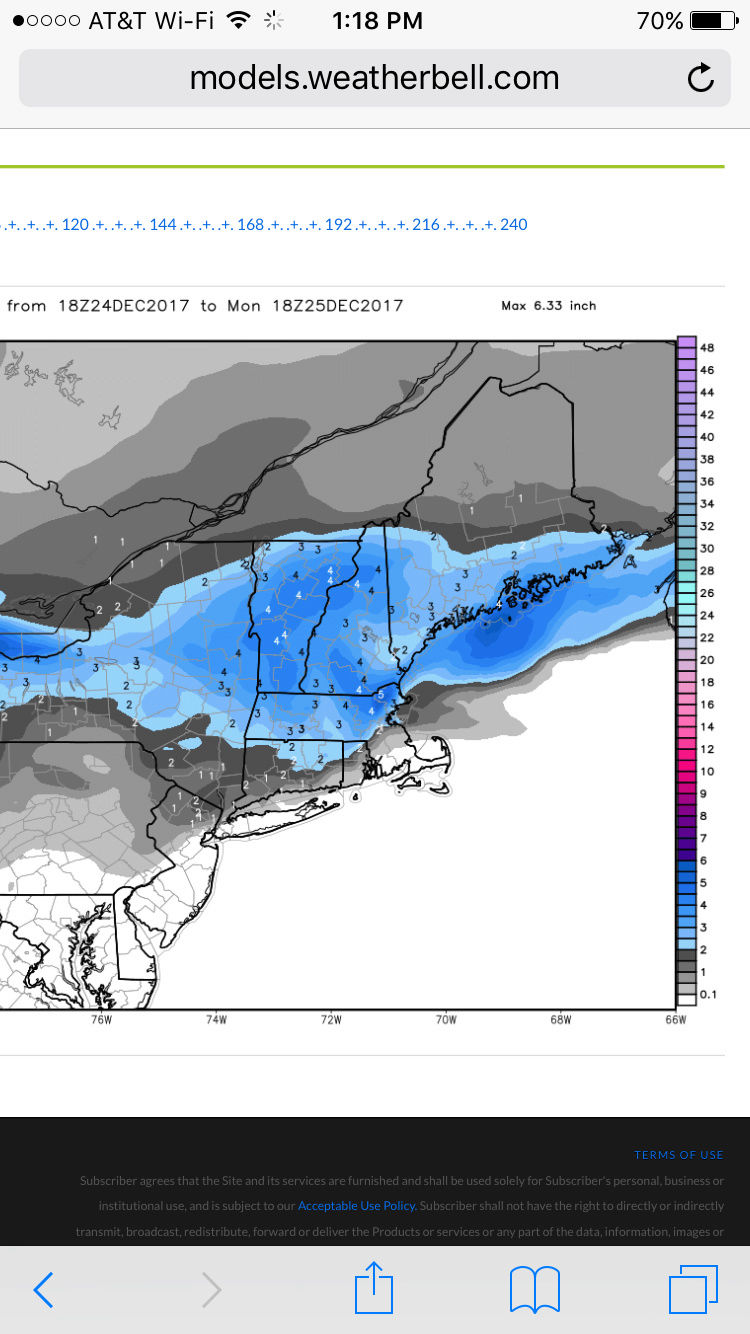
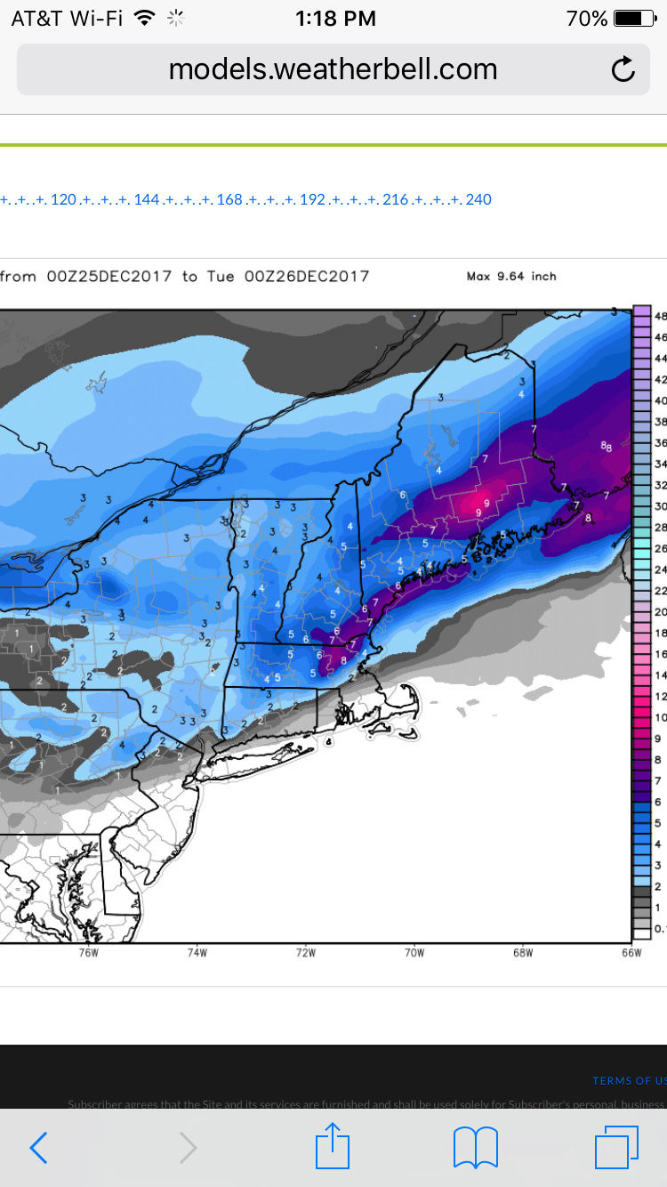
rb924119 wrote:00z:
12z:
_________________
"In weather and in life, there's no winning and losing; there's only winning and learning."
WINTER 2012/2013 TOTALS 43.65"WINTER 2017/2018 TOTALS 62.85" WINTER 2022/2023 TOTALS 4.9"
WINTER 2013/2014 TOTALS 64.85"WINTER 2018/2019 TOTALS 14.25" WINTER 2023/2024 TOTALS 13.1"
WINTER 2014/2015 TOTALS 71.20"WINTER 2019/2020 TOTALS 6.35"
WINTER 2015/2016 TOTALS 35.00"WINTER 2020/2021 TOTALS 37.75"
WINTER 2016/2017 TOTALS 42.25"WINTER 2021/2022 TOTALS 31.65"

sroc4- Admin
- Posts : 8354
Reputation : 302
Join date : 2013-01-07
Location : Wading River, LI
Re: Possible Christmas Day Storm
![]() by bobjohnsonforthehall Fri Dec 22, 2017 1:55 pm
by bobjohnsonforthehall Fri Dec 22, 2017 1:55 pm
sroc4 wrote:rb924119 wrote:00z:
12z:
That one really seems to be struggling. Bangor went from 2 inches to 9 from one run to the next? Not buying it.
Edit: nevermind. Two different time periods. My bad.

bobjohnsonforthehall- Posts : 311
Reputation : 19
Join date : 2016-10-02
Location : Flemington NJ
Re: Possible Christmas Day Storm
![]() by rb924119 Fri Dec 22, 2017 2:26 pm
by rb924119 Fri Dec 22, 2017 2:26 pm
Also of note the EURO now has the dual jet structure. Meaning? If it continues depicting that, I expect a wetter trend with the QPF.
rb924119- Meteorologist
- Posts : 6928
Reputation : 194
Join date : 2013-02-06
Age : 32
Location : Greentown, Pa
Re: Possible Christmas Day Storm
![]() by amugs Fri Dec 22, 2017 4:19 pm
by amugs Fri Dec 22, 2017 4:19 pm
From Dougie

_________________
Mugs
AKA:King: Snow Weenie
Self Proclaimed
WINTER 2014-15 : 55.12" +.02 for 6 coatings (avg. 35")
WINTER 2015-16 Total - 29.8" (Avg 35")
WINTER 2016-17 : 39.5" so far

amugs- Advanced Forecaster - Mod

- Posts : 15095
Reputation : 213
Join date : 2013-01-07
Age : 54
Location : Hillsdale,NJ
Re: Possible Christmas Day Storm
![]() by amugs Fri Dec 22, 2017 4:22 pm
by amugs Fri Dec 22, 2017 4:22 pm
Swiped this from another bd. This depicts me to a T

_________________
Mugs
AKA:King: Snow Weenie
Self Proclaimed
WINTER 2014-15 : 55.12" +.02 for 6 coatings (avg. 35")
WINTER 2015-16 Total - 29.8" (Avg 35")
WINTER 2016-17 : 39.5" so far
amugs- Advanced Forecaster - Mod
- Posts : 15095
Reputation : 213
Join date : 2013-01-07
Age : 54
Location : Hillsdale,NJ
Re: Possible Christmas Day Storm
![]() by frank 638 Fri Dec 22, 2017 6:25 pm
by frank 638 Fri Dec 22, 2017 6:25 pm
frank 638- Senior Enthusiast
- Posts : 2843
Reputation : 37
Join date : 2016-01-01
Age : 40
Location : bronx ny
Re: Possible Christmas Day Storm
![]() by docstox12 Fri Dec 22, 2017 6:46 pm
by docstox12 Fri Dec 22, 2017 6:46 pm

docstox12- Wx Statistician Guru
- Posts : 8530
Reputation : 222
Join date : 2013-01-07
Age : 73
Location : Monroe NY
Re: Possible Christmas Day Storm
![]() by weatherwatchermom Fri Dec 22, 2017 8:23 pm
by weatherwatchermom Fri Dec 22, 2017 8:23 pm

weatherwatchermom- Senior Enthusiast
- Posts : 3793
Reputation : 78
Join date : 2014-11-25
Location : Hazlet Township, NJ
Re: Possible Christmas Day Storm
![]() by frank 638 Fri Dec 22, 2017 8:27 pm
by frank 638 Fri Dec 22, 2017 8:27 pm
frank 638- Senior Enthusiast
- Posts : 2843
Reputation : 37
Join date : 2016-01-01
Age : 40
Location : bronx ny
Re: Possible Christmas Day Storm
![]() by CPcantmeasuresnow Fri Dec 22, 2017 9:02 pm
by CPcantmeasuresnow Fri Dec 22, 2017 9:02 pm
weatherwatchermom wrote:can someone tell me when the last time Nj had snow actually on Christmas Day..my husband and I are having a debate..I can not find records in my google search..thank you!!
The last measurable snow in NYC on Christmas Day was in 2009, 2.0 inches, there was more in NNJ.
Christmas 2002 the city had 5-7 inches and the northern suburbs a foot and a half, 16.8 IMBY. My favorite Christmas of all time.
CPcantmeasuresnow- Wx Statistician Guru
- Posts : 7274
Reputation : 230
Join date : 2013-01-07
Age : 103
Location : Eastern Orange County, NY
Re: Possible Christmas Day Storm
![]() by docstox12 Fri Dec 22, 2017 9:08 pm
by docstox12 Fri Dec 22, 2017 9:08 pm
CPcantmeasuresnow wrote:weatherwatchermom wrote:can someone tell me when the last time Nj had snow actually on Christmas Day..my husband and I are having a debate..I can not find records in my google search..thank you!!
The last measurable snow in NYC on Christmas Day was in 2009, 2.0 inches, there was more in NNJ.
Christmas 2002 the city had 5-7 inches and the northern suburbs a foot and a half, 16.8 IMBY. My favorite Christmas of all time.
CP , you brought back a great memory! My GF at the time, now my Wife,had just moved up to Monroe a week before and there was 17 inches as you say.Mahwah had maybe a foot.As I was driving up and noticed much more snow in Monroe I said to myself..."I'm gonna LOVE it up here in winter"!.
docstox12- Wx Statistician Guru
- Posts : 8530
Reputation : 222
Join date : 2013-01-07
Age : 73
Location : Monroe NY
Re: Possible Christmas Day Storm
![]() by rb924119 Fri Dec 22, 2017 10:05 pm
by rb924119 Fri Dec 22, 2017 10:05 pm
rb924119- Meteorologist
- Posts : 6928
Reputation : 194
Join date : 2013-02-06
Age : 32
Location : Greentown, Pa
Re: Possible Christmas Day Storm
![]() by aiannone Fri Dec 22, 2017 10:27 pm
by aiannone Fri Dec 22, 2017 10:27 pm
_________________
-Alex Iannone-

aiannone- Senior Enthusiast - Mod
- Posts : 4815
Reputation : 92
Join date : 2013-01-07
Location : Saint James, LI (Northwest Suffolk Co.)
Re: Possible Christmas Day Storm
![]() by sroc4 Sat Dec 23, 2017 8:54 am
by sroc4 Sat Dec 23, 2017 8:54 am
Here is a close up of the 500mb vorticity maps. I will be using the 00z Euro for all maps. I have been saying in the past few days that in order for this to trend better I wanted to see the trough dig a little further south into the Tenn Valley, but it looks like is will come up a tad short. By 06z Dec25th there is a consensus among modeling both short range and Globals that there will be a vort max that is rounding the base of the trough creating a primary low at the surface that tracks through NWestern NY state. At the same time a secondary low is beginning to form just east of the Delmarva/S jersey shore; south of LI in response to the main vort max of the trough. As the trough continues east the transfer of energy from the low to the NW to the new primary off the coast takes place and the new low deepens.

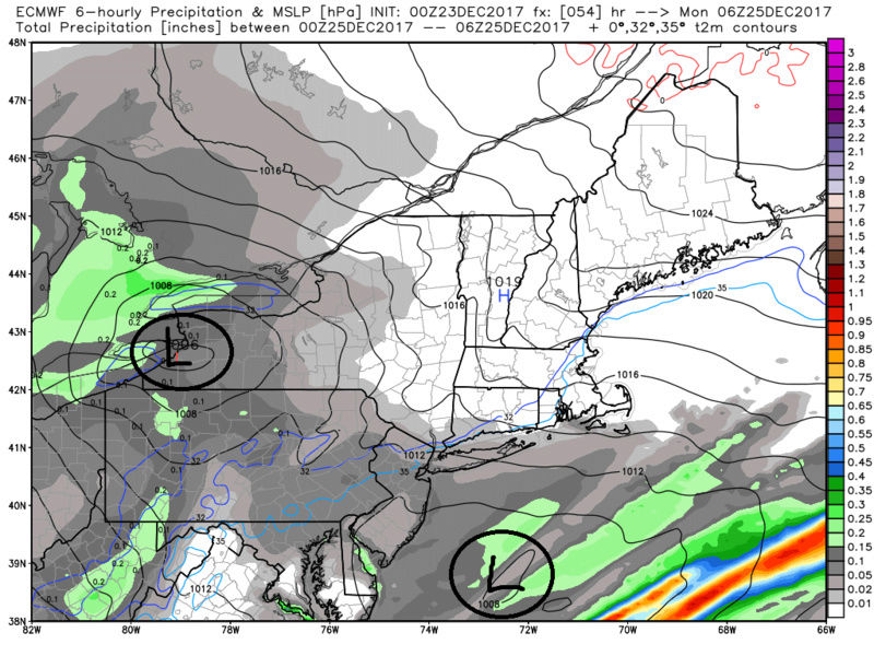

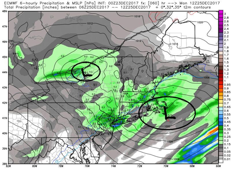

The problem with this set up is because the main trough does not dig far enough south it allows that initial primary to get too far N&W of the area. The result of this is this: Here are the surface wind maps followed by the surface temps, 925mb, and 850mb temps. As you can clearly see the result is unfavorable wind directions coming off the ocean until its much too late for the coastal plain. The coastal plain remains above freezing throughout the event and eastern sections see a warm nose in the mid levels come in.
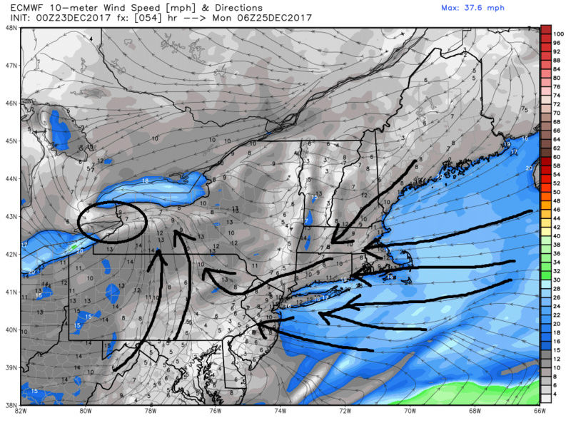
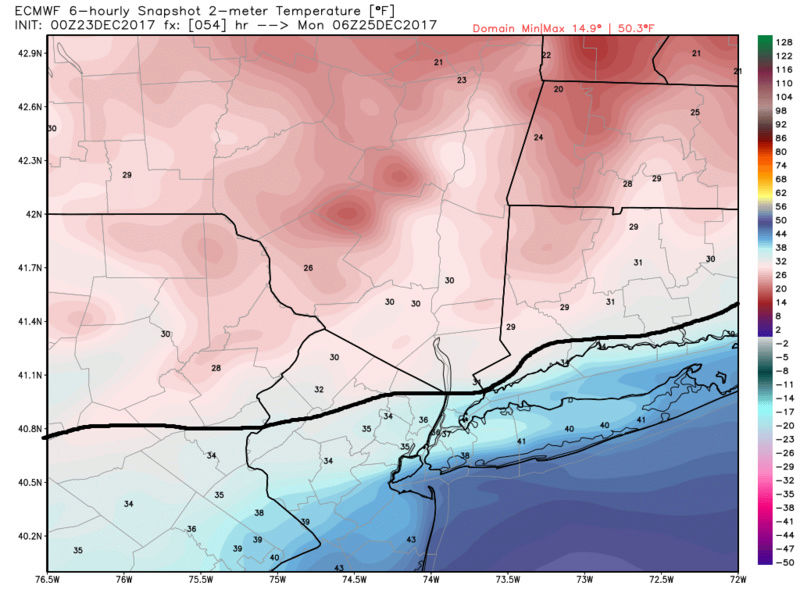
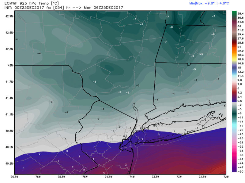

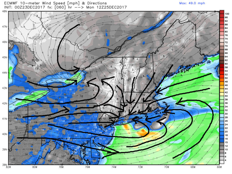

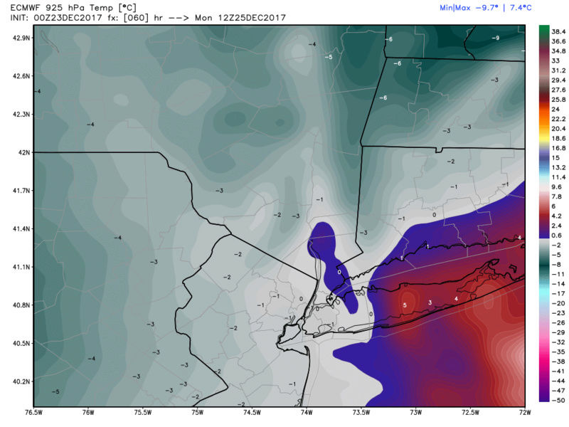
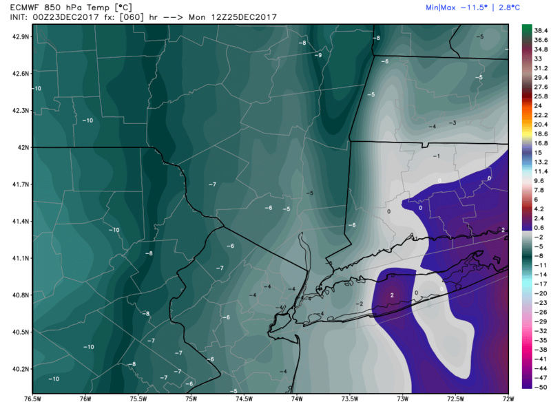

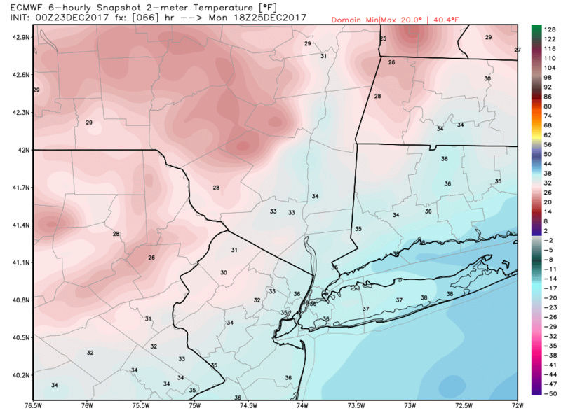
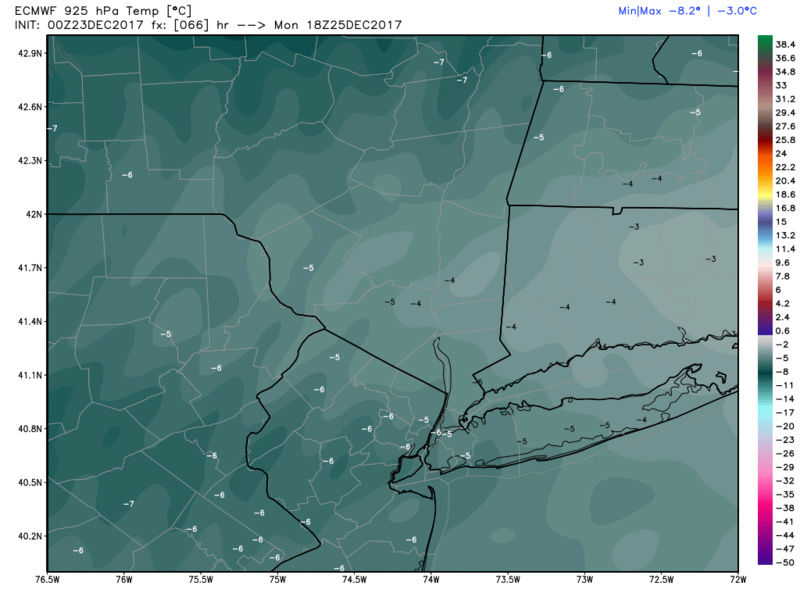
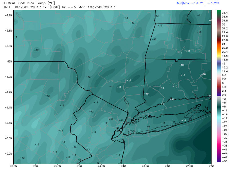
If the trough dug deeper it would not have allowed the initail primary to gain as much lattitude before transferring to the coast and the colder soln would likely ensue. I still think some areas N&W will end up with 1-3 isolated 3-5". There is still 2days until this event unfolds and the freezing lines from surface to 850mb are hovering right around the coastal plain. There is still time for subtle shifting, 25-50 miles, to the upper level energy; the results of which could lead to differences in outcome. Those within the blue circle would be the ones most likely affected by the shift. There are still subtle differences in some of the details I posted above among the diff models. This may boil down to observations, and not models along the coastal plain. Watch the surface maps for timing and changes in wind direction compared to where the precip is etc. No matter the outcome it is not 60*


_________________
"In weather and in life, there's no winning and losing; there's only winning and learning."
WINTER 2012/2013 TOTALS 43.65"WINTER 2017/2018 TOTALS 62.85" WINTER 2022/2023 TOTALS 4.9"
WINTER 2013/2014 TOTALS 64.85"WINTER 2018/2019 TOTALS 14.25" WINTER 2023/2024 TOTALS 13.1"
WINTER 2014/2015 TOTALS 71.20"WINTER 2019/2020 TOTALS 6.35"
WINTER 2015/2016 TOTALS 35.00"WINTER 2020/2021 TOTALS 37.75"
WINTER 2016/2017 TOTALS 42.25"WINTER 2021/2022 TOTALS 31.65"
sroc4- Admin
- Posts : 8354
Reputation : 302
Join date : 2013-01-07
Location : Wading River, LI
Page 4 of 9 • 1, 2, 3, 4, 5, 6, 7, 8, 9 ![]()