December 2020 Observations and Discussion
+23
algae888
weatherwatchermom
SENJsnowman
HectorO
1190ftalt
bobjohnsonforthehall
essexcountypete
Taffy
CPcantmeasuresnow
hyde345
aiannone
phil155
jmanley32
brownie
Frank_Wx
sroc4
heehaw453
mwilli
frank 638
Grselig
amugs
billg315
Dunnzoo
27 posters
Page 6 of 11
Page 6 of 11 •  1, 2, 3 ... 5, 6, 7 ... 9, 10, 11
 Re: December 2020 Observations and Discussion
Totally overperformed here with snow falling for the past 2 hours.
Areas in NW NJ reporting 1.25 of white gold!!
Areas in NW NJ reporting 1.25 of white gold!!
amugs- Advanced Forecaster - Mod

- Posts : 15095
Join date : 2013-01-07
 Re: December 2020 Observations and Discussion
They just plowed the road in my Lake Community in Stillwater NJ at 1190 feet altitude! Winter is Finally here !
1190ftalt- Pro Enthusiast

- Posts : 401
Join date : 2013-12-13
amugs and HectorO like this post
 Re: December 2020 Observations and Discussion
It snowed for most of the day here. Picked up a nice coating on the deck, grass and shrubs, though it has melted off the driveway and walk. Still looks beautiful and will look even more beautiful when I turn on the outside Christmas lights.
Just what I needed today!!
Just what I needed today!!
brownie- Posts : 393
Reputation : 17
Join date : 2013-11-10
Location : Parsippany, NJ
 Re: December 2020 Observations and Discussion
I STILL have some snowflakes flying here, but radar indicates this is the last round. Solid coating to an inch on non-paved surfaces. Trees looked beautiful coated with snow.

billg315- Advanced Forecaster - Mod

- Posts : 4483
Reputation : 185
Join date : 2015-01-24
Age : 50
Location : Flemington, NJ
 Re: December 2020 Observations and Discussion
It is not often I’d say a storm giving me a coating to an inch only on colder surfaces “overperformed,” but this one sure did at least aesthetically. Several hours of beautiful light to moderate snowfall to watch and a coating of white on trees and rooftops with light snow still falling at sunset. Much more than I expected.

billg315- Advanced Forecaster - Mod

- Posts : 4483
Reputation : 185
Join date : 2015-01-24
Age : 50
Location : Flemington, NJ
SENJsnowman likes this post
 Re: December 2020 Observations and Discussion
We had an hour of beautiful falling snow today!!!! just sat and gazed out the window!!! low temp today was 29* Hi temp today was 35*

weatherwatchermom- Senior Enthusiast

- Posts : 3793
Reputation : 78
Join date : 2014-11-25
Location : Hazlet Township, NJ
 Re: December 2020 Observations and Discussion
Unfort I didnt get the same over achieving that many to my west experienced as it seems the QPF fell apart once over LI, but I did definitely have steady flurries for about a half hour. It was so nice to see, and once again that smell of snow. I love it!
_________________
"In weather and in life, there's no winning and losing; there's only winning and learning."
WINTER 2012/2013 TOTALS 43.65"WINTER 2017/2018 TOTALS 62.85" WINTER 2022/2023 TOTALS 4.9"
WINTER 2013/2014 TOTALS 64.85"WINTER 2018/2019 TOTALS 14.25" WINTER 2023/2024 TOTALS 13.1"
WINTER 2014/2015 TOTALS 71.20"WINTER 2019/2020 TOTALS 6.35"
WINTER 2015/2016 TOTALS 35.00"WINTER 2020/2021 TOTALS 37.75"
WINTER 2016/2017 TOTALS 42.25"WINTER 2021/2022 TOTALS 31.65"

sroc4- Admin

- Posts : 8354
Reputation : 302
Join date : 2013-01-07
Location : Wading River, LI
 Re: December 2020 Observations and Discussion
Snowed for 4 hours here steady in light to moderate fashion - IF it happened 5-6 hours earlier we woudl have had 1" of white gold coating the ground BUT it was not here just west of me there was stickage.
Eye turn to next week midweek 1st one not the show though may seem like it


This could be the show - my bday present to ya'll??

Strung out a bit here on GEFS - but signal is there

Eye turn to next week midweek 1st one not the show though may seem like it


This could be the show - my bday present to ya'll??

Strung out a bit here on GEFS - but signal is there

_________________
Mugs
AKA:King: Snow Weenie
Self Proclaimed
WINTER 2014-15 : 55.12" +.02 for 6 coatings (avg. 35")
WINTER 2015-16 Total - 29.8" (Avg 35")
WINTER 2016-17 : 39.5" so far

amugs- Advanced Forecaster - Mod

- Posts : 15095
Reputation : 213
Join date : 2013-01-07
Age : 54
Location : Hillsdale,NJ
 Re: December 2020 Observations and Discussion
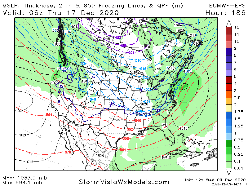
EPS has a good signal at this range and the torch some were expecting isnt so torchy but rather slightly AN


_________________
Mugs
AKA:King: Snow Weenie
Self Proclaimed
WINTER 2014-15 : 55.12" +.02 for 6 coatings (avg. 35")
WINTER 2015-16 Total - 29.8" (Avg 35")
WINTER 2016-17 : 39.5" so far

amugs- Advanced Forecaster - Mod

- Posts : 15095
Reputation : 213
Join date : 2013-01-07
Age : 54
Location : Hillsdale,NJ
 Re: December 2020 Observations and Discussion
Euro and icon are a major snow storm Wednesday into Thursday of next week. Nice cold high pressure to on North and with the block over Greenland the ow stalls just stalls south and east of Long Island the CMC and the GFS are warmer with mainly rain. Still 7 days to go and all major models showing a system for next week with the Greenland block my hunch is we'll see some wintry precipitation here with this system.as for the Monday night into Tuesday Storm still have to monitor that as most of the models brought the wave back this evening with just a glancing blow but some of the ensembles take it further north to impact our area with rain and snow very exciting times ahead

algae888- Advanced Forecaster

- Posts : 5311
Reputation : 46
Join date : 2013-02-05
Age : 62
Location : mt. vernon, new york
Radz likes this post
 Re: December 2020 Observations and Discussion
Nice look on the models for next week- I’m guessing the cold solution wins out with the -nao, fingers crossed
Radz- Pro Enthusiast

- Posts : 1028
Reputation : 17
Join date : 2013-01-12
Location : Cortlandt Manor NY
 Re: December 2020 Observations and Discussion
The 6z GFS has one to two feet of snow for most of Northern New Jersey in the lower Hudson Valley in the next two weeks. Lesser amounts near the coast. What a pattern coming up this could be epic I never seen such deep red over Greenland

algae888- Advanced Forecaster

- Posts : 5311
Reputation : 46
Join date : 2013-02-05
Age : 62
Location : mt. vernon, new york
 Re: December 2020 Observations and Discussion
There could be a lot of winter forecast bust this year. History tells us when you get a legit negative AO and negative Nao in December it usually lasts for a while these don't break down too quickly. The very good news is this is happening as we are heading into Peak climo when we really do not need very cold air to make things work very exciting times ahead not a lot of sleep for the next few weeks or months

algae888- Advanced Forecaster

- Posts : 5311
Reputation : 46
Join date : 2013-02-05
Age : 62
Location : mt. vernon, new york
 Re: December 2020 Observations and Discussion
algae888 wrote:There could be a lot of winter forecast bust this year. History tells us when you get a legit negative AO and negative Nao in December it usually lasts for a while these don't break down too quickly. The very good news is this is happening as we are heading into Peak climo when we really do not need very cold air to make things work very exciting times ahead not a lot of sleep for the next few weeks or months
I would take my chances with a good Atlantic and support from the arctic even with a subpar Pacific. The Atlantic support makes cutters much less likely. Being better than last year should be easy enough though.
heehaw453- Advanced Forecaster

- Posts : 3906
Reputation : 86
Join date : 2014-01-20
Location : Bedminster Township, PA Elevation 600' ASL
 Re: December 2020 Observations and Discussion
Mugs, that would be a nice present to us all. Also, how nice you are here to give it.

dkodgis- Senior Enthusiast

- Posts : 2560
Reputation : 98
Join date : 2013-12-29
 Re: December 2020 Observations and Discussion
IT"S COMING!!!! ALL 3 GLOBALS Are HARPING/BARKING FOR A NICE BDAY PRESENT TO MY FAMILY HERE!!!!
My theory on why we are such blocking is 2 part:
1> All of the Convective Heat Release from the Numerous Hcanes - remember this heat has to go somewhere and where you have these numerous storms - though some should not have been named IMO but that's different story for another time, we have this tremendous release of heat into the arctic region. these highly charged Water Vapor molecules, remember salt water is charged, needs to go up into teh atmosphere and it usually travels to......the geomagnetic pole. Now with such a late season influx of storms - many were after Sept. we had massive amounts heading into poleward. Now it doesn't all make it up there but if you notice a good number of storms went up above the 50N Latitude. Now again just a theory on this I have to due some more research to pick up some analogs to see the validity of this idea.
Part 2 - Low Solar Lag effect. It takes a year or so for this to affect the earth in larger, broader ways and this started back in 2017
2020 total: 206 days (60%)
2019 total: 281 days (77%)
2018 total: 221 days (61%)
2017 total: 104 days (28%)
The majority of the quiet sun days were in teh 2nd half of that year (2017).
We have seen thorugh teh course of historical records relating to weather and geomagnetic events such as Earthquakes adn Volcanoes that Low Solar will produce PV splits, elongations, Strong Arctic High Pressure and Greenland Block after the low solar period - the last time we had such a blocky artic...2009 -10, and again 10-11.
2010 total: 51 days (14%)
2009 total: 260 days (71%)
2008 total: 268 days (73%)
2007 total: 152 days (42%)
Now again will this come to fruition??? IS anyone's guess but we know that we have had such and when we look at the low solar cycle chart - the time between the ending of one cycle and the beginning of another we have blocky arctic and Antarctic winters.
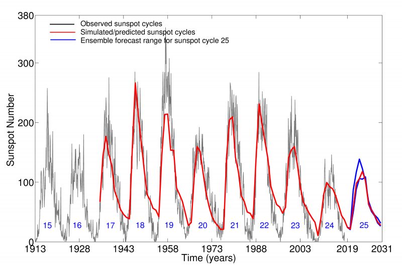

Long term cycle
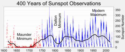
Chart to show Worldwide temperatures over a period of time taken from tree rings and ice core samples.

My theory on why we are such blocking is 2 part:
1> All of the Convective Heat Release from the Numerous Hcanes - remember this heat has to go somewhere and where you have these numerous storms - though some should not have been named IMO but that's different story for another time, we have this tremendous release of heat into the arctic region. these highly charged Water Vapor molecules, remember salt water is charged, needs to go up into teh atmosphere and it usually travels to......the geomagnetic pole. Now with such a late season influx of storms - many were after Sept. we had massive amounts heading into poleward. Now it doesn't all make it up there but if you notice a good number of storms went up above the 50N Latitude. Now again just a theory on this I have to due some more research to pick up some analogs to see the validity of this idea.
Part 2 - Low Solar Lag effect. It takes a year or so for this to affect the earth in larger, broader ways and this started back in 2017
2020 total: 206 days (60%)
2019 total: 281 days (77%)
2018 total: 221 days (61%)
2017 total: 104 days (28%)
The majority of the quiet sun days were in teh 2nd half of that year (2017).
We have seen thorugh teh course of historical records relating to weather and geomagnetic events such as Earthquakes adn Volcanoes that Low Solar will produce PV splits, elongations, Strong Arctic High Pressure and Greenland Block after the low solar period - the last time we had such a blocky artic...2009 -10, and again 10-11.
2010 total: 51 days (14%)
2009 total: 260 days (71%)
2008 total: 268 days (73%)
2007 total: 152 days (42%)
Now again will this come to fruition??? IS anyone's guess but we know that we have had such and when we look at the low solar cycle chart - the time between the ending of one cycle and the beginning of another we have blocky arctic and Antarctic winters.

Long term cycle

Chart to show Worldwide temperatures over a period of time taken from tree rings and ice core samples.

_________________
Mugs
AKA:King: Snow Weenie
Self Proclaimed
WINTER 2014-15 : 55.12" +.02 for 6 coatings (avg. 35")
WINTER 2015-16 Total - 29.8" (Avg 35")
WINTER 2016-17 : 39.5" so far

amugs- Advanced Forecaster - Mod

- Posts : 15095
Reputation : 213
Join date : 2013-01-07
Age : 54
Location : Hillsdale,NJ
 Re: December 2020 Observations and Discussion
You can really see how blocking (-NAO) helps with our snow chances on the 12Z GFS today for 12/17. Strong high just gets pinned and cold press oozes down from it. With progressive flows this is much more difficult to keep the cold around. High would scoot quickly and we'd loose the cold quickly as the storm would tend to want to cut west.
I'm not paying attention to op runs ATTM, but this op run clearly shows the magic of blocking IMO.
I'm not paying attention to op runs ATTM, but this op run clearly shows the magic of blocking IMO.
heehaw453- Advanced Forecaster

- Posts : 3906
Reputation : 86
Join date : 2014-01-20
Location : Bedminster Township, PA Elevation 600' ASL
 Re: December 2020 Observations and Discussion
heehaw453 wrote:You can really see how blocking (-NAO) helps with our snow chances on the 12Z GFS today for 12/17. Strong high just gets pinned and cold press oozes down from it. With progressive flows this is much more difficult to keep the cold around. High would scoot quickly and we'd loose the cold quickly as the storm would tend to want to cut west.
I'm not paying attention to op runs ATTM, but this op run clearly shows the magic of blocking IMO.
Concur!
Amazing how the blocking has major affects on the total downstream pattern and arctic region over the top
The AO, NAO couplet and add the PNA for a three some like the old Three Dog Night band!
Look at that Block - teh red orangy colors over Greenland
AS SROC said hoping not a head fake!!

_________________
Mugs
AKA:King: Snow Weenie
Self Proclaimed
WINTER 2014-15 : 55.12" +.02 for 6 coatings (avg. 35")
WINTER 2015-16 Total - 29.8" (Avg 35")
WINTER 2016-17 : 39.5" so far

amugs- Advanced Forecaster - Mod

- Posts : 15095
Reputation : 213
Join date : 2013-01-07
Age : 54
Location : Hillsdale,NJ
 Re: December 2020 Observations and Discussion
Gefs show maybe some white gold Monday/Tuesday as well and multiple opportunities after that time frame
_________________
Mugs
AKA:King: Snow Weenie
Self Proclaimed
WINTER 2014-15 : 55.12" +.02 for 6 coatings (avg. 35")
WINTER 2015-16 Total - 29.8" (Avg 35")
WINTER 2016-17 : 39.5" so far

amugs- Advanced Forecaster - Mod

- Posts : 15095
Reputation : 213
Join date : 2013-01-07
Age : 54
Location : Hillsdale,NJ
 Re: December 2020 Observations and Discussion
Everyone is in the game IMO for the 12/16-12/17 threat. Jersey coastal plain very much so. I love high pressure pumping fresh cold air into a deep moisture fetch. The high is just pinned and is the factory that is required for most significant widespread snows to occur. The track will adjust more SE IMO as the models catch onto the blocking. This could be a very significant event.
heehaw453- Advanced Forecaster

- Posts : 3906
Reputation : 86
Join date : 2014-01-20
Location : Bedminster Township, PA Elevation 600' ASL
SENJsnowman likes this post
 Re: December 2020 Observations and Discussion
heehaw453 wrote:Everyone is in the game IMO for the 12/16-12/17 threat. Jersey coastal plain very much so. I love high pressure pumping fresh cold air into a deep moisture fetch. The high is just pinned and is the factory that is required for most significant widespread snows to occur. The track will adjust more SE IMO as the models catch onto the blocking. This could be a very significant event.
I hope so..fingers crossed

weatherwatchermom- Senior Enthusiast

- Posts : 3793
Reputation : 78
Join date : 2014-11-25
Location : Hazlet Township, NJ
 Re: December 2020 Observations and Discussion
GEFS coming N with this 1st wave - appetizer peeps colder and nice coating to couple of inches.
to those boohooers the pattern is TOTALLY different with this, the Atlantic is cooperating bigly.
We have all 3 major models showing this - is it CCP interference? Putin Collusion? If so then close the board down LOL!

to those boohooers the pattern is TOTALLY different with this, the Atlantic is cooperating bigly.
We have all 3 major models showing this - is it CCP interference? Putin Collusion? If so then close the board down LOL!

_________________
Mugs
AKA:King: Snow Weenie
Self Proclaimed
WINTER 2014-15 : 55.12" +.02 for 6 coatings (avg. 35")
WINTER 2015-16 Total - 29.8" (Avg 35")
WINTER 2016-17 : 39.5" so far

amugs- Advanced Forecaster - Mod

- Posts : 15095
Reputation : 213
Join date : 2013-01-07
Age : 54
Location : Hillsdale,NJ
 Re: December 2020 Observations and Discussion
amugs wrote:GEFS coming N with this 1st wave - appetizer peeps colder and nice coating to couple of inches.
to those boohooers the pattern is TOTALLY different with this, the Atlantic is cooperating bigly.
We have all 3 major models showing this - is it CCP interference? Putin Collusion? If so then close the board down LOL!
Yeah, I could see C-1" for some on that. BL temps are marginal.
heehaw453- Advanced Forecaster

- Posts : 3906
Reputation : 86
Join date : 2014-01-20
Location : Bedminster Township, PA Elevation 600' ASL
 Re: December 2020 Observations and Discussion
No changes on guidance overnight. Need this to hold another 36 to 48 hours to get really excited about mid-week system. Still have to watch for a minor event on Monday but temperatures are not in our favor for any accumulations

algae888- Advanced Forecaster

- Posts : 5311
Reputation : 46
Join date : 2013-02-05
Age : 62
Location : mt. vernon, new york
 Re: December 2020 Observations and Discussion
The weather channel already has me for next wed into wed night for 6 to 8 inches for snow I know it’s way to early for snow amounts and things will change
frank 638- Senior Enthusiast

- Posts : 2843
Reputation : 37
Join date : 2016-01-01
Age : 40
Location : bronx ny
 Re: December 2020 Observations and Discussion
frank 638 wrote:The weather channel already has me for next wed into wed night for 6 to 8 inches for snow I know it’s way to early for snow amounts and things will change
That's just ridiculous, way too early to put out accumulations!
_________________
Janet
Snowfall winter of 2023-2024 17.5"
Snowfall winter of 2022-2023 6.0"
Snowfall winter of 2021-2022 17.6" 1" sleet 2/25/22
Snowfall winter of 2020-2021 51.1"
Snowfall winter of 2019-2020 8.5"
Snowfall winter of 2018-2019 25.1"
Snowfall winter of 2017-2018 51.9"
Snowfall winter of 2016-2017 45.6"
Snowfall winter of 2015-2016 29.5"
Snowfall winter of 2014-2015 50.55"
Snowfall winter of 2013-2014 66.5"
Dunnzoo- Senior Enthusiast - Mod

- Posts : 4904
Reputation : 68
Join date : 2013-01-11
Age : 62
Location : Westwood, NJ
 Re: December 2020 Observations and Discussion
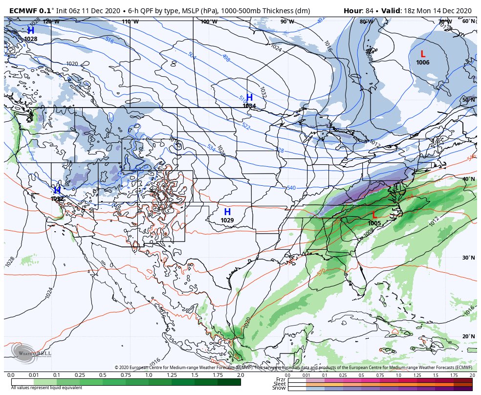
Pump the breaks for Monday system 1st peeps - told ya'll it was coming North

_________________
Mugs
AKA:King: Snow Weenie
Self Proclaimed
WINTER 2014-15 : 55.12" +.02 for 6 coatings (avg. 35")
WINTER 2015-16 Total - 29.8" (Avg 35")
WINTER 2016-17 : 39.5" so far

amugs- Advanced Forecaster - Mod

- Posts : 15095
Reputation : 213
Join date : 2013-01-07
Age : 54
Location : Hillsdale,NJ
Page 6 of 11 •  1, 2, 3 ... 5, 6, 7 ... 9, 10, 11
Page 6 of 11
Permissions in this forum:
You cannot reply to topics in this forum|
|
|

 Home
Home