
 Search
Monitoring February 4th
Page 8 of 13 •  1, 2, 3 ... 7, 8, 9 ... 11, 12, 13
 ![]()
Re: Monitoring February 4th
![]() by SoulSingMG Thu Feb 03, 2022 6:02 am
by SoulSingMG Thu Feb 03, 2022 6:02 am
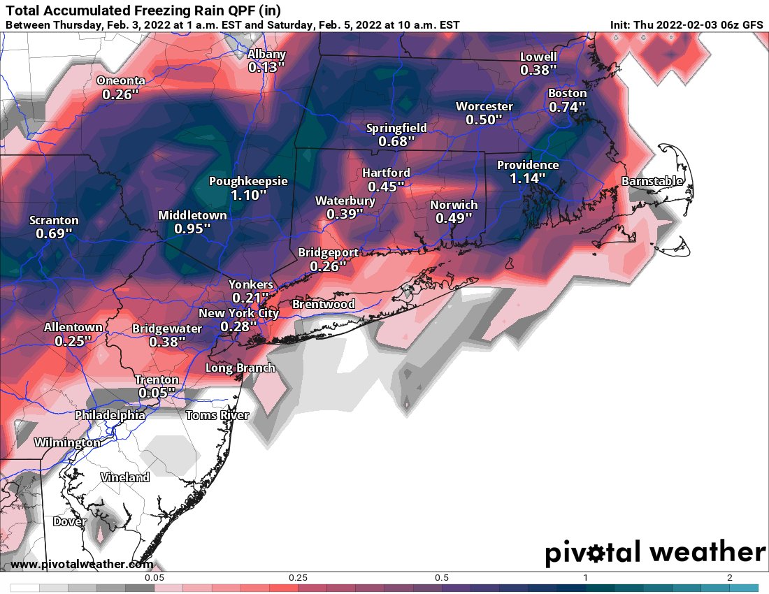
RAIN THIS EVENING TRANSITIONS TO A WINTRY MIX CONSISTING MOSTLY
OF SLEET AND FREEZING RAIN FROM NORTHWEST TO SOUTHEAST LATE
TONIGHT INTO FRIDAY. HIGHER CONFIDENCE AND MORE ICE
ACCUMULATIONS EXPECTED ACROSS THE INTERIOR WHERE A WINTER
WEATHER ADVISORY IS IN EFFECT FROM LATE TONIGHT THROUGH FRIDAY,
ENDING EARLY FRIDAY NIGHT. LESS CONFIDENCE ON ICE ACCUMULATIONS,
WHICH ARE A FEW HUNDREDTHS OF AN INCH TOWARDS THE COAST WHERE
THERE IS NO ADVISORY. SREF PROBABILITIES OF FREEZING RAIN HAVE
DECREASED HERE COMPARED TO THE PREVIOUS FORECAST. HRRR ALSO
KEEPS MILDER TEMPERATURES ALONG THE COAST. THERE WILL STILL BE
POTENTIAL FOR BRIEF FREEZING RAIN BUT THE DURATION OF IT AND
SMALL AMOUNTS FORECAST FOR FRIDAY AFTERNOON ARE MAKING FOR LESS
CONFIDENCE.
FOR FRIDAY NIGHT, PRECIPITATION MOVES EAST OF THE REGION AS THE
COLD FRONT MOVES WELL OFFSHORE. LOW TEMPERATURES FORECAST IN THE
LOWER TEENS TO LOWER 20S BUT NW GUSTY WINDS WILL BE IN PLACE.
SoulSingMG- Senior Enthusiast

- Posts : 2853
Join date : 2013-12-11
Re: Monitoring February 4th
![]() by amugs Thu Feb 03, 2022 6:47 am
by amugs Thu Feb 03, 2022 6:47 am
URGENT - WINTER WEATHER MESSAGE
National Weather Service New York NY
356 AM EST Thu Feb 3 2022
NJZ004-103>106-NYZ069>071-032130-
/O.NEW.KOKX.WW.Y.0008.220204T1100Z-220204T2300Z/
Eastern Passaic-Western Bergen-Eastern Bergen-Western Essex-
Eastern Essex-Rockland-Northern Westchester-Southern Westchester-
356 AM EST Thu Feb 3 2022
...WINTER WEATHER ADVISORY IN EFFECT FROM 6 AM TO 6 PM EST
FRIDAY...
* WHAT...Mixed precipitation expected. Total snow accumulations
of up to one inch and ice accumulations of up to two tenths of
an inch.
* WHERE...Portions of northeast New Jersey and southeast New
York.
* WHEN...From 6 AM to 6 PM EST Friday.
* IMPACTS...Plan on slippery road conditions. The hazardous
conditions could impact the Friday morning commute.
PRECAUTIONARY/PREPAREDNESS ACTIONS...
Slow down and use caution while traveling.
Check local Department of Transportation information services for
the latest road conditions.
&&
amugs- Advanced Forecaster - Mod

- Posts : 15093
Join date : 2013-01-07
Re: Monitoring February 4th
![]() by heehaw453 Thu Feb 03, 2022 6:52 am
by heehaw453 Thu Feb 03, 2022 6:52 am
Euro 2 Days Ago

GFS 2 Days Ago

This morning GFS

heehaw453- Advanced Forecaster

- Posts : 3906
Reputation : 86
Join date : 2014-01-20
Location : Bedminster Township, PA Elevation 600' ASL
JT33 likes this post
Re: Monitoring February 4th
![]() by docstox12 Thu Feb 03, 2022 7:28 am
by docstox12 Thu Feb 03, 2022 7:28 am

docstox12- Wx Statistician Guru

- Posts : 8502
Reputation : 222
Join date : 2013-01-07
Age : 73
Location : Monroe NY
essexcountypete likes this post
Re: Monitoring February 4th
![]() by amugs Thu Feb 03, 2022 8:13 am
by amugs Thu Feb 03, 2022 8:13 am
_________________
Mugs
AKA:King: Snow Weenie
Self Proclaimed
WINTER 2014-15 : 55.12" +.02 for 6 coatings (avg. 35")
WINTER 2015-16 Total - 29.8" (Avg 35")
WINTER 2016-17 : 39.5" so far

amugs- Advanced Forecaster - Mod
- Posts : 15093
Reputation : 213
Join date : 2013-01-07
Age : 54
Location : Hillsdale,NJ
Re: Monitoring February 4th
![]() by heehaw453 Thu Feb 03, 2022 8:28 am
by heehaw453 Thu Feb 03, 2022 8:28 am
heehaw453- Advanced Forecaster
- Posts : 3906
Reputation : 86
Join date : 2014-01-20
Location : Bedminster Township, PA Elevation 600' ASL
MattyICE likes this post
Re: Monitoring February 4th
![]() by essexcountypete Thu Feb 03, 2022 9:04 am
by essexcountypete Thu Feb 03, 2022 9:04 am
docstox12 wrote:I am surprised there are no flood warnings from heavy rains and snow melt today and tonight before the freeze.NWS says 1 to 2 inches of rain tonight up here after 1/2 inch today.
True that. And frozen ground means water can't be absorbed in normally permeable places. Lots of ponding. Glad that all the snow and ice in my gutters melted, I was worried about damning. I imagine there will be lots of wet basements too.

essexcountypete- Pro Enthusiast

- Posts : 783
Reputation : 12
Join date : 2013-12-09
Location : Bloomfield, NJ
Re: Monitoring February 4th
![]() by TheAresian Thu Feb 03, 2022 9:12 am
by TheAresian Thu Feb 03, 2022 9:12 am
TheAresian- Senior Enthusiast
- Posts : 145
Reputation : 10
Join date : 2019-11-13
Location : Painted Post, NY
essexcountypete, jmanley32 and weatherwatchermom like this post
Re: Monitoring February 4th
![]() by heehaw453 Thu Feb 03, 2022 10:38 am
by heehaw453 Thu Feb 03, 2022 10:38 am

heehaw453- Advanced Forecaster
- Posts : 3906
Reputation : 86
Join date : 2014-01-20
Location : Bedminster Township, PA Elevation 600' ASL
Re: Monitoring February 4th
![]() by amugs Thu Feb 03, 2022 11:01 am
by amugs Thu Feb 03, 2022 11:01 am
The 12z HREF continues to be quicker with the low level cold air vs most guidance. 7am tomorrow shown. Always a tough call to bet against the HREF.
— eweather (@Eweather13) February 3, 2022
I can’t argue with this look. pic.twitter.com/TGvf2kTupt
_________________
Mugs
AKA:King: Snow Weenie
Self Proclaimed
WINTER 2014-15 : 55.12" +.02 for 6 coatings (avg. 35")
WINTER 2015-16 Total - 29.8" (Avg 35")
WINTER 2016-17 : 39.5" so far
amugs- Advanced Forecaster - Mod
- Posts : 15093
Reputation : 213
Join date : 2013-01-07
Age : 54
Location : Hillsdale,NJ
weatherwatchermom likes this post
Re: Monitoring February 4th
![]() by heehaw453 Thu Feb 03, 2022 11:25 am
by heehaw453 Thu Feb 03, 2022 11:25 am

heehaw453- Advanced Forecaster
- Posts : 3906
Reputation : 86
Join date : 2014-01-20
Location : Bedminster Township, PA Elevation 600' ASL
MattyICE likes this post
Re: Monitoring February 4th
![]() by amugs Thu Feb 03, 2022 11:54 am
by amugs Thu Feb 03, 2022 11:54 am

_________________
Mugs
AKA:King: Snow Weenie
Self Proclaimed
WINTER 2014-15 : 55.12" +.02 for 6 coatings (avg. 35")
WINTER 2015-16 Total - 29.8" (Avg 35")
WINTER 2016-17 : 39.5" so far
amugs- Advanced Forecaster - Mod
- Posts : 15093
Reputation : 213
Join date : 2013-01-07
Age : 54
Location : Hillsdale,NJ
Re: Monitoring February 4th
![]() by docstox12 Thu Feb 03, 2022 11:55 am
by docstox12 Thu Feb 03, 2022 11:55 am
heehaw453 wrote:Aresian let us know how it goes up there. Close call for your area, but you should get at least 6". I got a few friends in Central Ohio too that are not quite sure what to expect.
Wow, again ridiculous cut offs.Our man Aresian out on the western frontier will be the only one on our site to cash in on snow! Good for him, he always has to watch as the coast cashes in.
docstox12- Wx Statistician Guru
- Posts : 8502
Reputation : 222
Join date : 2013-01-07
Age : 73
Location : Monroe NY
essexcountypete, jmanley32, heehaw453 and JT33 like this post
Re: Monitoring February 4th
![]() by amugs Thu Feb 03, 2022 1:00 pm
by amugs Thu Feb 03, 2022 1:00 pm
GFS and 3K NAM show this best - RGEM, NAM, HRRR too warm hmmmm.... could be interesting if HREFs nail this. An hour or two tomorrow morning is really tight for commuters.

_________________
Mugs
AKA:King: Snow Weenie
Self Proclaimed
WINTER 2014-15 : 55.12" +.02 for 6 coatings (avg. 35")
WINTER 2015-16 Total - 29.8" (Avg 35")
WINTER 2016-17 : 39.5" so far
amugs- Advanced Forecaster - Mod
- Posts : 15093
Reputation : 213
Join date : 2013-01-07
Age : 54
Location : Hillsdale,NJ
Re: Monitoring February 4th
![]() by heehaw453 Thu Feb 03, 2022 2:59 pm
by heehaw453 Thu Feb 03, 2022 2:59 pm

heehaw453- Advanced Forecaster
- Posts : 3906
Reputation : 86
Join date : 2014-01-20
Location : Bedminster Township, PA Elevation 600' ASL
Re: Monitoring February 4th
![]() by lglickman1 Thu Feb 03, 2022 3:33 pm
by lglickman1 Thu Feb 03, 2022 3:33 pm
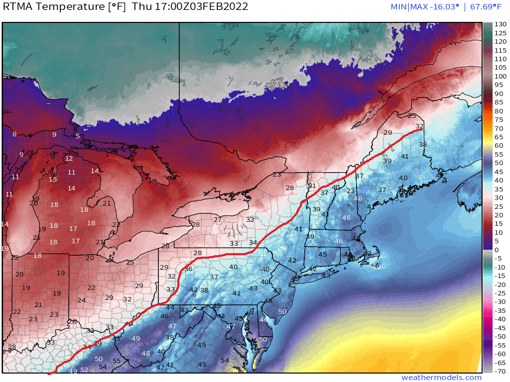
heehaw453 wrote:This is why the storm is warm. Look at how far 1020 line has pushed northward. Had that been below Mason Dixon Line another animal.
What is the significance of the 1020 line?
lglickman1- Pro Enthusiast
- Posts : 319
Reputation : 0
Join date : 2013-02-05
Location : New Rochelle, NY
Re: Monitoring February 4th
![]() by heehaw453 Thu Feb 03, 2022 3:51 pm
by heehaw453 Thu Feb 03, 2022 3:51 pm
lglickman1 wrote:heehaw453 wrote:This is why the storm is warm. Look at how far 1020 line has pushed northward. Had that been below Mason Dixon Line another animal.
What is the significance of the 1020 line?
Push of warm air.
heehaw453- Advanced Forecaster
- Posts : 3906
Reputation : 86
Join date : 2014-01-20
Location : Bedminster Township, PA Elevation 600' ASL
Re: Monitoring February 4th
![]() by TheAresian Thu Feb 03, 2022 3:59 pm
by TheAresian Thu Feb 03, 2022 3:59 pm
TheAresian- Senior Enthusiast
- Posts : 145
Reputation : 10
Join date : 2019-11-13
Location : Painted Post, NY
Re: Monitoring February 4th
![]() by SoulSingMG Thu Feb 03, 2022 4:09 pm
by SoulSingMG Thu Feb 03, 2022 4:09 pm


SoulSingMG- Senior Enthusiast
- Posts : 2853
Reputation : 74
Join date : 2013-12-11
Location : Long Island City, NY
Re: Monitoring February 4th
![]() by heehaw453 Thu Feb 03, 2022 4:15 pm
by heehaw453 Thu Feb 03, 2022 4:15 pm
925's

Surface wet bulb

heehaw453- Advanced Forecaster
- Posts : 3906
Reputation : 86
Join date : 2014-01-20
Location : Bedminster Township, PA Elevation 600' ASL
Re: Monitoring February 4th
![]() by heehaw453 Thu Feb 03, 2022 4:16 pm
by heehaw453 Thu Feb 03, 2022 4:16 pm
TheAresian wrote:I'm not going to cash in as much as I'd like. The NAM has been bullish on sleet for me and they're right. Snow has turned to sleet.
Are you thinking at least 6"?
heehaw453- Advanced Forecaster
- Posts : 3906
Reputation : 86
Join date : 2014-01-20
Location : Bedminster Township, PA Elevation 600' ASL
Re: Monitoring February 4th
![]() by TheAresian Thu Feb 03, 2022 4:49 pm
by TheAresian Thu Feb 03, 2022 4:49 pm
TheAresian- Senior Enthusiast
- Posts : 145
Reputation : 10
Join date : 2019-11-13
Location : Painted Post, NY
Frank_Wx, brownie, essexcountypete, heehaw453, weatherwatchermom and SENJsnowman like this post
Re: Monitoring February 4th
![]() by heehaw453 Thu Feb 03, 2022 4:59 pm
by heehaw453 Thu Feb 03, 2022 4:59 pm
TheAresian wrote:It's back to snow now so barring another change back to sleet 6" should be easily reachable.
I think the warmest approach of the storm to your area has occurred and the energy will continue to get more strung out. I would expect mid-level temps to continue to fall and any change-back in the near term will be brief. Enjoy!
heehaw453- Advanced Forecaster
- Posts : 3906
Reputation : 86
Join date : 2014-01-20
Location : Bedminster Township, PA Elevation 600' ASL
Re: Monitoring February 4th
![]() by amugs Thu Feb 03, 2022 5:08 pm
by amugs Thu Feb 03, 2022 5:08 pm
_________________
Mugs
AKA:King: Snow Weenie
Self Proclaimed
WINTER 2014-15 : 55.12" +.02 for 6 coatings (avg. 35")
WINTER 2015-16 Total - 29.8" (Avg 35")
WINTER 2016-17 : 39.5" so far
amugs- Advanced Forecaster - Mod
- Posts : 15093
Reputation : 213
Join date : 2013-01-07
Age : 54
Location : Hillsdale,NJ
Re: Monitoring February 4th
![]() by heehaw453 Thu Feb 03, 2022 6:01 pm
by heehaw453 Thu Feb 03, 2022 6:01 pm
amugs wrote:Bring on the ice and whatever else momma has to throw at us. Artic air seems to be on the move now. See how it matches up with models at this point.
Temperatures will rise a bit over the next 4-6 hours as the storm consolidates to our south, and then the baroclinic zone tightens. It's only after that consolidation that the advance of the cold air can continue as the storm pulls east. That's the part that screwed the NW folks as it's just too close to the area that this occurs and of course takes a really long time.
heehaw453- Advanced Forecaster
- Posts : 3906
Reputation : 86
Join date : 2014-01-20
Location : Bedminster Township, PA Elevation 600' ASL
Re: Monitoring February 4th
![]() by TheAresian Thu Feb 03, 2022 6:51 pm
by TheAresian Thu Feb 03, 2022 6:51 pm
TheAresian- Senior Enthusiast
- Posts : 145
Reputation : 10
Join date : 2019-11-13
Location : Painted Post, NY
Re: Monitoring February 4th
![]() by rb924119 Thu Feb 03, 2022 7:08 pm
by rb924119 Thu Feb 03, 2022 7:08 pm
rb924119- Meteorologist

- Posts : 6889
Reputation : 194
Join date : 2013-02-06
Age : 32
Location : Greentown, Pa
Page 8 of 13 • 1, 2, 3 ... 7, 8, 9 ... 11, 12, 13 ![]()
|
|
|