December Obs & Discussions
Page 3 of 6 •  1, 2, 3, 4, 5, 6
 Re: December Obs & Discussions
dkodgis- Senior Enthusiast

- Posts : 2560
Join date : 2013-12-29
 Re: December Obs & Discussions
amugs- Advanced Forecaster - Mod

- Posts : 15095
Join date : 2013-01-07
 Re: December Obs & Discussions

weatherwatchermom- Senior Enthusiast

- Posts : 3793
Reputation : 78
Join date : 2014-11-25
Location : Hazlet Township, NJ
 Re: December Obs & Discussions

jmanley32- Senior Enthusiast

- Posts : 20535
Reputation : 108
Join date : 2013-12-12
Age : 43
Location : Yonkers, NY
 Re: December Obs & Discussions
heehaw453- Advanced Forecaster

- Posts : 3906
Reputation : 86
Join date : 2014-01-20
Location : Bedminster Township, PA Elevation 600' ASL
 Re: December Obs & Discussions

jmanley32- Senior Enthusiast

- Posts : 20535
Reputation : 108
Join date : 2013-12-12
Age : 43
Location : Yonkers, NY
 Re: December Obs & Discussions
phil155- Pro Enthusiast

- Posts : 483
Reputation : 4
Join date : 2019-12-16
 Re: December Obs & Discussions
yeah but with the Temps and several inches rain it likely won't stick.phil155 wrote:Hoping that there is actually some backend snow with the artic front

jmanley32- Senior Enthusiast

- Posts : 20535
Reputation : 108
Join date : 2013-12-12
Age : 43
Location : Yonkers, NY
 Re: December Obs & Discussions
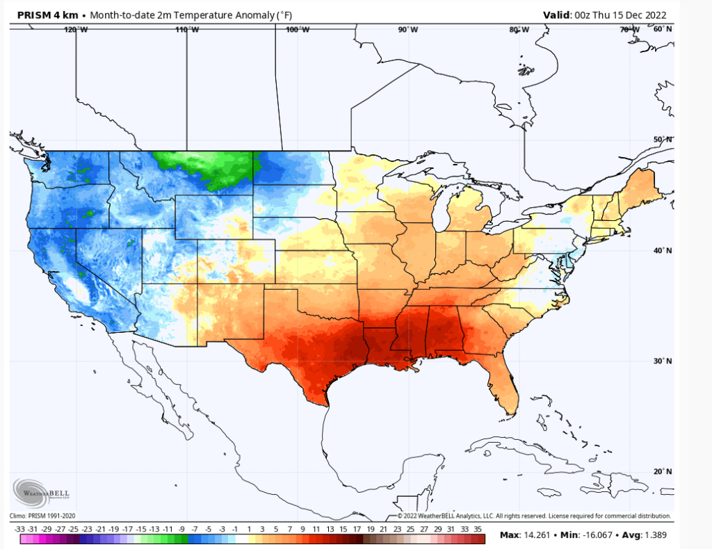
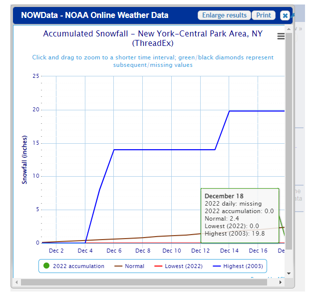
The lowest December snowfall when the AO averaged -2.000 or below was 5.1" in 1976. Total seasonal snowfall was 24.5". There is a chance that the December 1976 record futility could be surpassed this month.
heehaw453- Advanced Forecaster

- Posts : 3906
Reputation : 86
Join date : 2014-01-20
Location : Bedminster Township, PA Elevation 600' ASL
 Re: December Obs & Discussions
jmanley32 wrote:yeah but with the Temps and several inches rain it likely won't stick.phil155 wrote:Hoping that there is actually some backend snow with the artic front
Agreed but still hoping
phil155- Pro Enthusiast

- Posts : 483
Reputation : 4
Join date : 2019-12-16
 Re: December Obs & Discussions
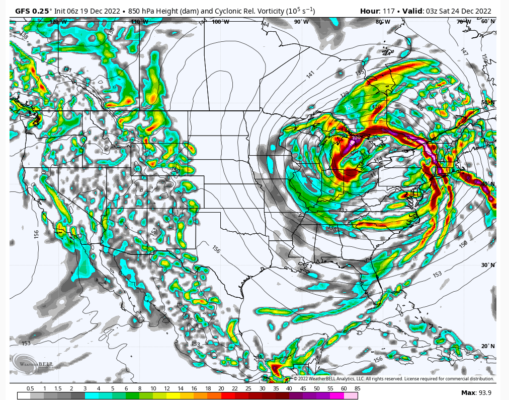
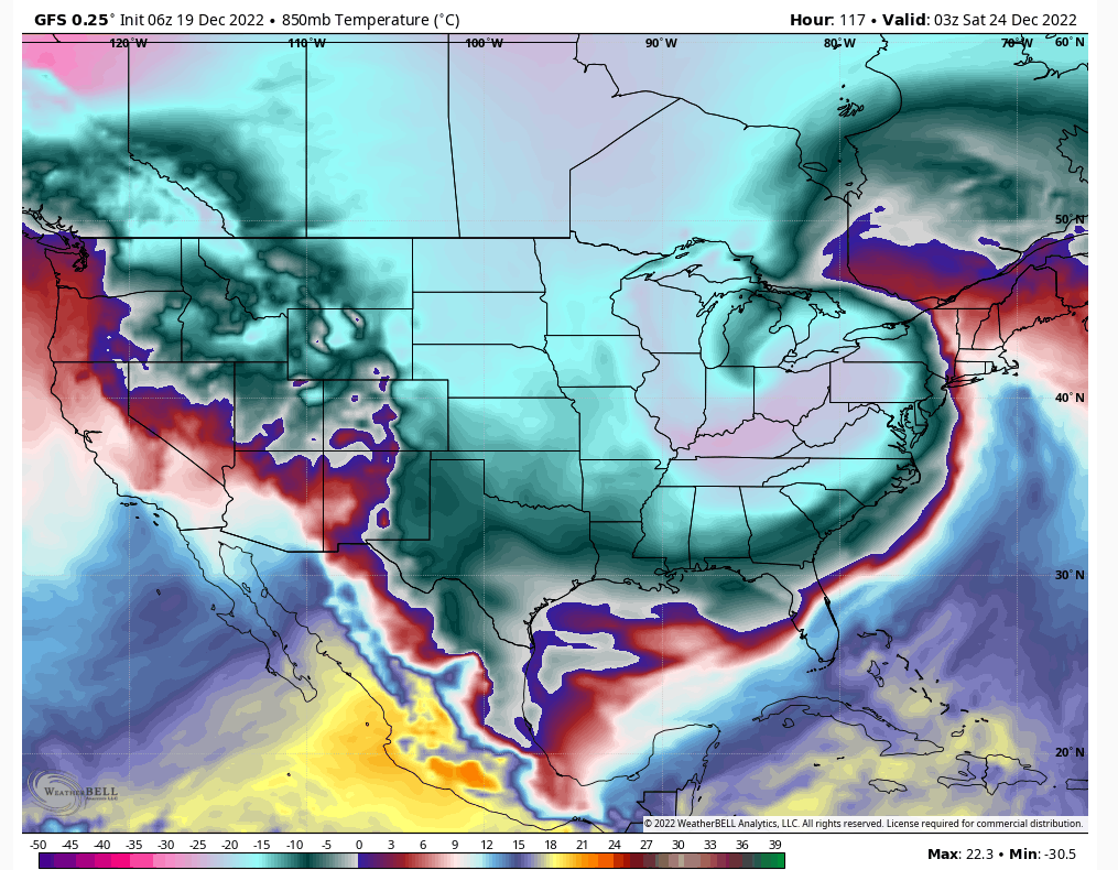
In this frame we got this mid-level energy that's offshore and the 500mb trough hasn't cleared the coast. If we can get a stronger wave then maybe some enhanced snow can fall from that. I am not a believer in any front end snow with this threat whatsoever due to the ridge being pulled down from the NAO block. The issue with these as usual is the speed at which they move at.phil155 wrote:Hoping that there is actually some backend snow with the artic front
heehaw453- Advanced Forecaster

- Posts : 3906
Reputation : 86
Join date : 2014-01-20
Location : Bedminster Township, PA Elevation 600' ASL
 Re: December Obs & Discussions
One thing is for sure, the weather next weekend -snow or no - will be much colder than is typical at Christmas, so it will feel plenty wintry.

billg315- Advanced Forecaster - Mod

- Posts : 4483
Reputation : 185
Join date : 2015-01-24
Age : 50
Location : Flemington, NJ
kalleg and dkodgis like this post
 Re: December Obs & Discussions
Cold without snow I would rather have warm temps. Bring the cold with the snow.billg315 wrote:While it looks increasingly like a sure-thing that this Thursday storm will be rain, I think there is a slight chance with that very potent cold air pouring into the region Friday into Saturday that we could see some snow flurries/showers. It wouldn’t be much, but maybe some Christmas Eve mood flakes?
One thing is for sure, the weather next weekend -snow or no - will be much colder than is typical at Christmas, so it will feel plenty wintry.

jmanley32- Senior Enthusiast

- Posts : 20535
Reputation : 108
Join date : 2013-12-12
Age : 43
Location : Yonkers, NY
 Re: December Obs & Discussions
I want to make sure this gets noticed: by all who have interest in GFS model snow fall in the United States. The model update on 11/30/22 I think is resulting in improved snowfall prediction. It certainly was a cyclically very good performer here in the I84 corridor coverage for 12/15-16. It's picking up on warm ground and elevations better.
I'd like to attach some snapshots of a recent NCEP meeting but can't seem to find the method. In short: 10x1 snow ratios don't work very well in 1000-500MB thickness above 540 DM, and not very well in snow-sleet (both greatly inflated). Instead it is recommended for the GGS to now consider Positive Snow Depth Change as a potential better ballpark solution.
Note: Using 10 to 1 is not going to be a consistently good approach, especially warm thickness (1000-500MB 540DM or higher) snows and/or temps 32-34F. This presentation also references Tropical Tidbits Positive Snow Depth Change (SNOD in NCEP language).
WDrag- Posts : 6
Reputation : 0
Join date : 2022-12-16
Location : Wantage NJ
Frank_Wx, CPcantmeasuresnow, Dunnzoo, kalleg, brownie, dkodgis and billg315 like this post
 Re: December Obs & Discussions
heehaw453- Advanced Forecaster

- Posts : 3906
Reputation : 86
Join date : 2014-01-20
Location : Bedminster Township, PA Elevation 600' ASL
kalleg and WDrag like this post
 Re: December Obs & Discussions
WDrag wrote:Hi... Introducing myself as Walt Drag-retired NWS and private sector AQWX, WSC,WXCORP. I'd like to add info about the recent GFS change on 11/30.
I want to make sure this gets noticed: by all who have interest in GFS model snow fall in the United States. The model update on 11/30/22 I think is resulting in improved snowfall prediction. It certainly was a cyclically very good performer here in the I84 corridor coverage for 12/15-16. It's picking up on warm ground and elevations better.
I'd like to attach some snapshots of a recent NCEP meeting but can't seem to find the method. In short: 10x1 snow ratios don't work very well in 1000-500MB thickness above 540 DM, and not very well in snow-sleet (both greatly inflated). Instead it is recommended for the GGS to now consider Positive Snow Depth Change as a potential better ballpark solution.
Note: Using 10 to 1 is not going to be a consistently good approach, especially warm thickness (1000-500MB 540DM or higher) snows and/or temps 32-34F. This presentation also references Tropical Tidbits Positive Snow Depth Change (SNOD in NCEP language).
Welcome and thank you very much for sharing this important piece of information with us. I personally was not aware of the change but it looks like it could have a big impact.
heehaw453 wrote:Hi Walt! Great to see you post here as many have seen you from American Weather Forums. The positive snow depth on the GFS was spot on for last storm. The 10:1 showed 1' of snow in some of the LHV areas, but the positive snow depth was a few inches and verified for the most part. This is the post that showed the maps.
Although it’s good to see the model verify, I never believed in those ridiculous amounts…H5 ULL was to our N&W.
_________________
_______________________________________________________________________________________________________
CLICK HERE to view NJ Strong Snowstorm Classifications
 Re: December Obs & Discussions
In a final insult by this terrible pattern, NWS has removed the 40% chance of snow showers for Friday night thereby eliminating any chance of a White Christmas.
"You're a mean one, Mr.Grinch......."!

docstox12- Wx Statistician Guru

- Posts : 8530
Reputation : 222
Join date : 2013-01-07
Age : 73
Location : Monroe NY
weatherwatchermom likes this post
 Re: December Obs & Discussions
lol I was looking forward last week for snow on Christmasdocstox12 wrote:28 degrees, clear, calm winds.
In a final insult by this terrible pattern, NWS has removed the 40% chance of snow showers for Friday night thereby eliminating any chance of a White Christmas.
"You're a mean one, Mr.Grinch......."!
 with our luck it would probably snow on Easter
frank 638- Senior Enthusiast

- Posts : 2843
Reputation : 37
Join date : 2016-01-01
Age : 40
Location : bronx ny
SENJsnowman and Meepers55 like this post
 Re: December Obs & Discussions
Love to hear your coments and outlooks down the road my man!!
This is just unreal:
Snow lovers in the East hearing this in their heads as we watched the trend west past few days pic.twitter.com/gLs5gblSHB
— Ralphs Weather OBS (@WeatherNut27) December 20, 2022
And that Cape May will be in the mid 20's whilst up in NNJ it'll be in the mid to upper 40's. This is really wild and an arctic front that swings SW to NE is something I HAVE NEVER SEEN in my 40 plus years of following weather.

Arctic front keeps speeding up which the models are starting to pick up on and may bring some back end snow showers with temps crashing 30 degrees in ~ 3 hours. May stick to colder surfaces...any snow is good snow peeps.
_________________
Mugs
AKA:King: Snow Weenie
Self Proclaimed
WINTER 2014-15 : 55.12" +.02 for 6 coatings (avg. 35")
WINTER 2015-16 Total - 29.8" (Avg 35")
WINTER 2016-17 : 39.5" so far

amugs- Advanced Forecaster - Mod

- Posts : 15095
Reputation : 213
Join date : 2013-01-07
Age : 54
Location : Hillsdale,NJ
Meepers55 likes this post
heehaw453- Advanced Forecaster

- Posts : 3906
Reputation : 86
Join date : 2014-01-20
Location : Bedminster Township, PA Elevation 600' ASL
amugs likes this post
 Re: December Obs & Discussions
Big time temperature drop associated with this late week cold front - temperatures falling as much as 30° F in 3 hours as the front sweeps eastward. Impressive stuff. pic.twitter.com/RimnO6tl94
— John Homenuk (@jhomenuk) December 20, 2022
Cool visual
_________________
Mugs
AKA:King: Snow Weenie
Self Proclaimed
WINTER 2014-15 : 55.12" +.02 for 6 coatings (avg. 35")
WINTER 2015-16 Total - 29.8" (Avg 35")
WINTER 2016-17 : 39.5" so far

amugs- Advanced Forecaster - Mod

- Posts : 15095
Reputation : 213
Join date : 2013-01-07
Age : 54
Location : Hillsdale,NJ
 Re: December Obs & Discussions
The secondary that pops coould surprise some in the far Western areas and maybe N areas as teh storm deepens and wraps up. This secondfary LP needs to slow up by a few more hours and allow that arctic front to press in quicker!! It keeeps making ticks east, we'll see by mood flakes are always welcomed!!!
_________________
Mugs
AKA:King: Snow Weenie
Self Proclaimed
WINTER 2014-15 : 55.12" +.02 for 6 coatings (avg. 35")
WINTER 2015-16 Total - 29.8" (Avg 35")
WINTER 2016-17 : 39.5" so far

amugs- Advanced Forecaster - Mod

- Posts : 15095
Reputation : 213
Join date : 2013-01-07
Age : 54
Location : Hillsdale,NJ
 Re: December Obs & Discussions
With the new moon and increasing SE winds, we will have to monitor high tides along around NY Harbor and other south/east facing shores on Friday morning. Moderate to locally major coastal flooding is possible. #nywx #njwx #ctwx pic.twitter.com/1pmqtSc3wX
— Miguel Pierre (@mpierre19) December 20, 2022
_________________
Mugs
AKA:King: Snow Weenie
Self Proclaimed
WINTER 2014-15 : 55.12" +.02 for 6 coatings (avg. 35")
WINTER 2015-16 Total - 29.8" (Avg 35")
WINTER 2016-17 : 39.5" so far

amugs- Advanced Forecaster - Mod

- Posts : 15095
Reputation : 213
Join date : 2013-01-07
Age : 54
Location : Hillsdale,NJ
 Re: December Obs & Discussions

weatherwatchermom- Senior Enthusiast

- Posts : 3793
Reputation : 78
Join date : 2014-11-25
Location : Hazlet Township, NJ
 Re: December Obs & Discussions
The temps will go down fast on Fri thus wind. What are we looking at?30-40 mph gusts?

dkodgis- Senior Enthusiast

- Posts : 2560
Reputation : 98
Join date : 2013-12-29
 Re: December Obs & Discussions

billg315- Advanced Forecaster - Mod

- Posts : 4483
Reputation : 185
Join date : 2015-01-24
Age : 50
Location : Flemington, NJ
phil155 likes this post
 Re: December Obs & Discussions
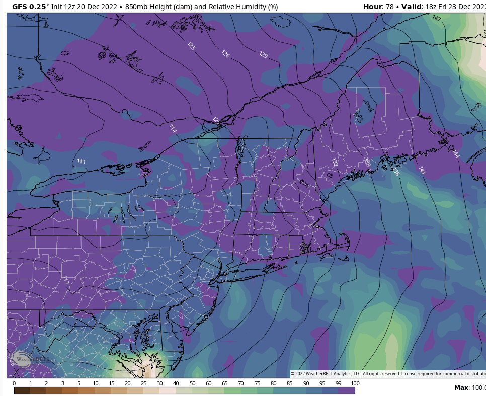
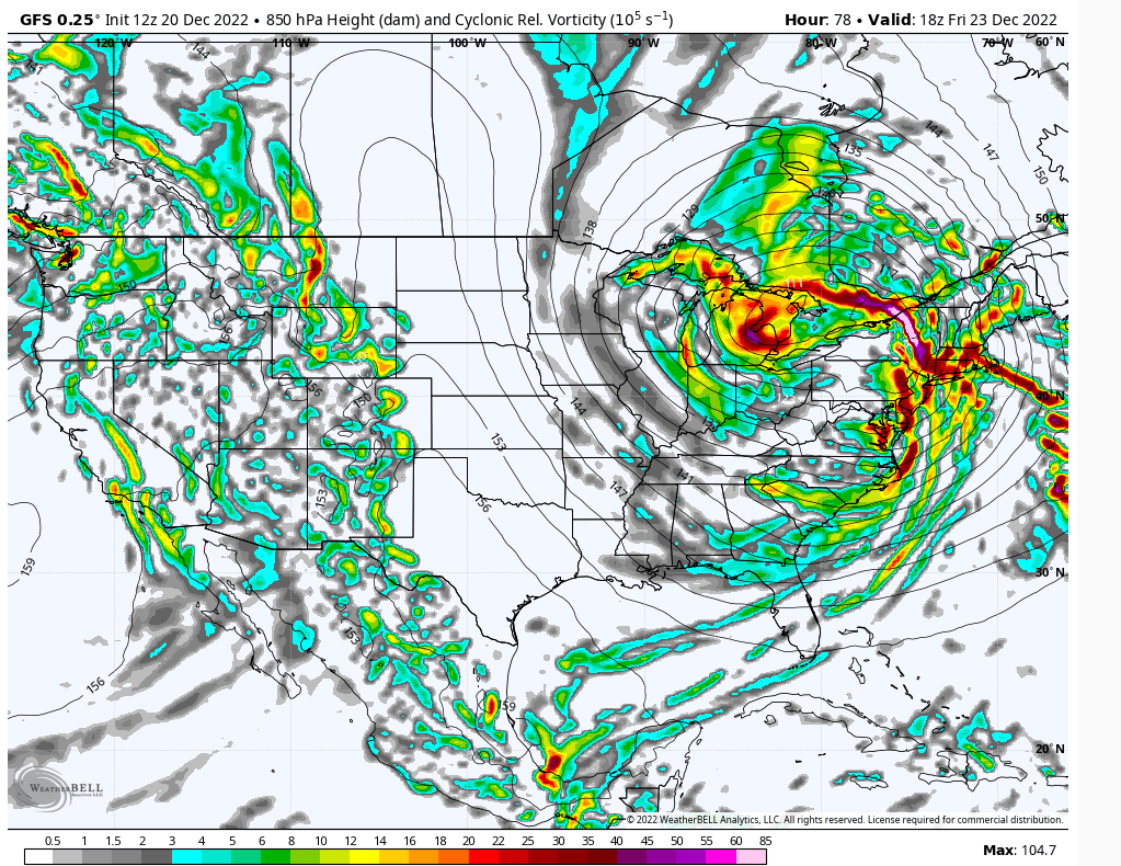
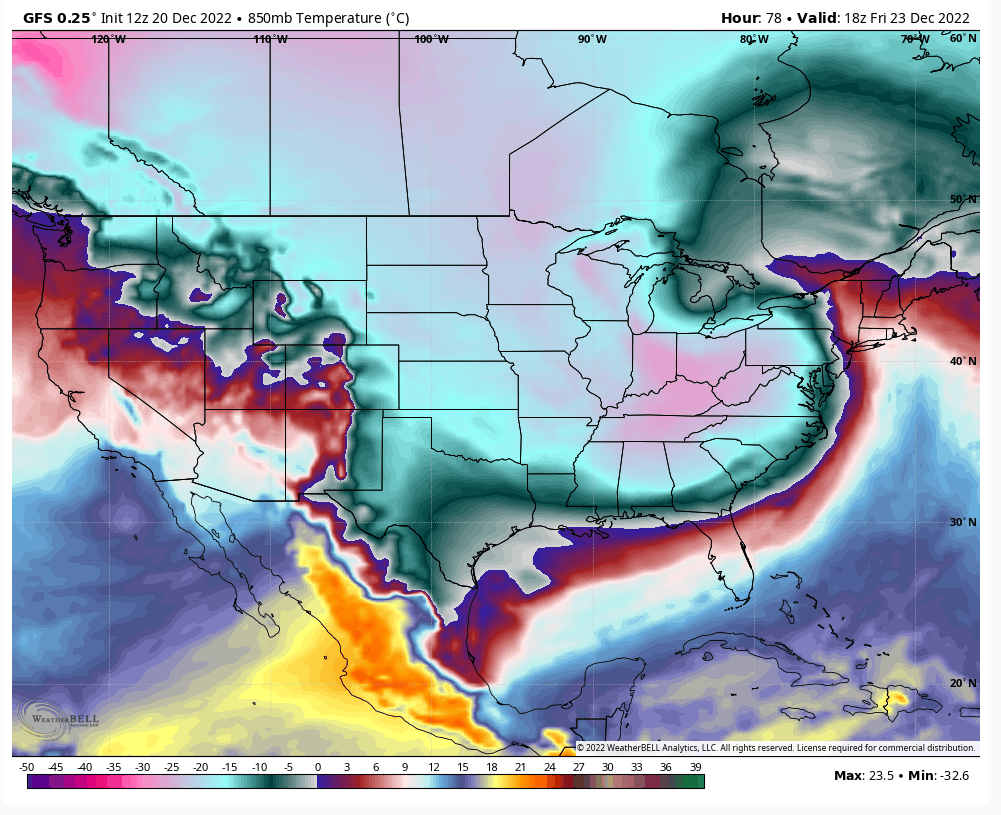
The temps won't be an issue at the mid and lower levels. The surface would be the last to crash and of course that's the one that affects accumulations. This is a lot of mid-level moisture that would have to swing through. No question there would be minor accumulations NW of 95 with this setup.
heehaw453- Advanced Forecaster

- Posts : 3906
Reputation : 86
Join date : 2014-01-20
Location : Bedminster Township, PA Elevation 600' ASL
amugs and phil155 like this post
Page 3 of 6 •  1, 2, 3, 4, 5, 6
|
|
|

 Home
Home
