
 Search
1st Call Snow Map, March 3rd-4th Storm Discussion 2.0
Page 8 of 13 •  1, 2, 3 ... 7, 8, 9 ... 11, 12, 13
 ![]()
Re: 1st Call Snow Map, March 3rd-4th Storm Discussion 2.0
![]() by NjWeatherGuy Sat Mar 01, 2014 10:44 am
by NjWeatherGuy Sat Mar 01, 2014 10:44 am
NjWeatherGuy- Advanced Forecaster

- Posts : 4100
Join date : 2013-01-06

aiannone- Senior Enthusiast - Mod

- Posts : 4813
Join date : 2013-01-07
Re: 1st Call Snow Map, March 3rd-4th Storm Discussion 2.0
![]() by Frank_Wx Sat Mar 01, 2014 10:45 am
by Frank_Wx Sat Mar 01, 2014 10:45 am
jmanley32 wrote:So thats it, no more chances for north or stronger run or is it still possible?
There are 00z runs tonight, but this is beginning to look like a south storm. The PV is too strong and the ridge in western Canada is pushing it too far south. Suppressive look. You do not usually see this in March
_________________
_______________________________________________________________________________________________________
CLICK HERE to view NJ Strong Snowstorm Classifications

Frank_Wx- Godzilla Seeker

- Posts : 21305
Reputation : 328
Join date : 2013-01-05
Age : 31
Location : Jersey City, NJ -

Re: 1st Call Snow Map, March 3rd-4th Storm Discussion 2.0
![]() by aiannone Sat Mar 01, 2014 10:46 am
by aiannone Sat Mar 01, 2014 10:46 am
_________________
-Alex Iannone-

aiannone- Senior Enthusiast - Mod
- Posts : 4813
Reputation : 92
Join date : 2013-01-07
Location : Saint James, LI (Northwest Suffolk Co.)
Re: 1st Call Snow Map, March 3rd-4th Storm Discussion 2.0
![]() by jimv45 Sat Mar 01, 2014 10:46 am
by jimv45 Sat Mar 01, 2014 10:46 am
jimv45- Senior Enthusiast

- Posts : 1168
Reputation : 36
Join date : 2013-09-20
Location : Hopewell jct.
Re: 1st Call Snow Map, March 3rd-4th Storm Discussion 2.0
![]() by Frank_Wx Sat Mar 01, 2014 10:47 am
by Frank_Wx Sat Mar 01, 2014 10:47 am

Looks like my 1st call
_________________
_______________________________________________________________________________________________________
CLICK HERE to view NJ Strong Snowstorm Classifications
Frank_Wx- Godzilla Seeker
- Posts : 21305
Reputation : 328
Join date : 2013-01-05
Age : 31
Location : Jersey City, NJ -
Re: 1st Call Snow Map, March 3rd-4th Storm Discussion 2.0
![]() by Frank_Wx Sat Mar 01, 2014 10:47 am
by Frank_Wx Sat Mar 01, 2014 10:47 am
Mets2695 wrote:Was the storm fully sampled for the 12z run?
Yes
_________________
_______________________________________________________________________________________________________
CLICK HERE to view NJ Strong Snowstorm Classifications
Frank_Wx- Godzilla Seeker
- Posts : 21305
Reputation : 328
Join date : 2013-01-05
Age : 31
Location : Jersey City, NJ -
Re: 1st Call Snow Map, March 3rd-4th Storm Discussion 2.0
![]() by Frank_Wx Sat Mar 01, 2014 10:48 am
by Frank_Wx Sat Mar 01, 2014 10:48 am
_________________
_______________________________________________________________________________________________________
CLICK HERE to view NJ Strong Snowstorm Classifications
Frank_Wx- Godzilla Seeker
- Posts : 21305
Reputation : 328
Join date : 2013-01-05
Age : 31
Location : Jersey City, NJ -
Re: 1st Call Snow Map, March 3rd-4th Storm Discussion 2.0
![]() by jimv45 Sat Mar 01, 2014 10:50 am
by jimv45 Sat Mar 01, 2014 10:50 am
jimv45- Senior Enthusiast
- Posts : 1168
Reputation : 36
Join date : 2013-09-20
Location : Hopewell jct.
Re: 1st Call Snow Map, March 3rd-4th Storm Discussion 2.0
![]() by amugs Sat Mar 01, 2014 10:50 am
by amugs Sat Mar 01, 2014 10:50 am
_________________
Mugs
AKA:King: Snow Weenie
Self Proclaimed
WINTER 2014-15 : 55.12" +.02 for 6 coatings (avg. 35")
WINTER 2015-16 Total - 29.8" (Avg 35")
WINTER 2016-17 : 39.5" so far

amugs- Advanced Forecaster - Mod
- Posts : 15093
Reputation : 213
Join date : 2013-01-07
Age : 54
Location : Hillsdale,NJ
Re: 1st Call Snow Map, March 3rd-4th Storm Discussion 2.0
![]() by aiannone Sat Mar 01, 2014 10:51 am
by aiannone Sat Mar 01, 2014 10:51 am
Frank_Wx wrote:NYC actually gets a solid 6 inches on the GFS. No one should be upset by this run. It is great for March standards.
My concern is NYC and LI is barely in the 6". So they have a better chance of getting 3-5" which isn't anything to really get excited about lol.
_________________
-Alex Iannone-
aiannone- Senior Enthusiast - Mod
- Posts : 4813
Reputation : 92
Join date : 2013-01-07
Location : Saint James, LI (Northwest Suffolk Co.)
Re: 1st Call Snow Map, March 3rd-4th Storm Discussion 2.0
![]() by NjWeatherGuy Sat Mar 01, 2014 10:51 am
by NjWeatherGuy Sat Mar 01, 2014 10:51 am

NjWeatherGuy- Advanced Forecaster
- Posts : 4100
Reputation : 28
Join date : 2013-01-06
Location : Belle Mead, NJ
Re: 1st Call Snow Map, March 3rd-4th Storm Discussion 2.0
![]() by Frank_Wx Sat Mar 01, 2014 10:53 am
by Frank_Wx Sat Mar 01, 2014 10:53 am
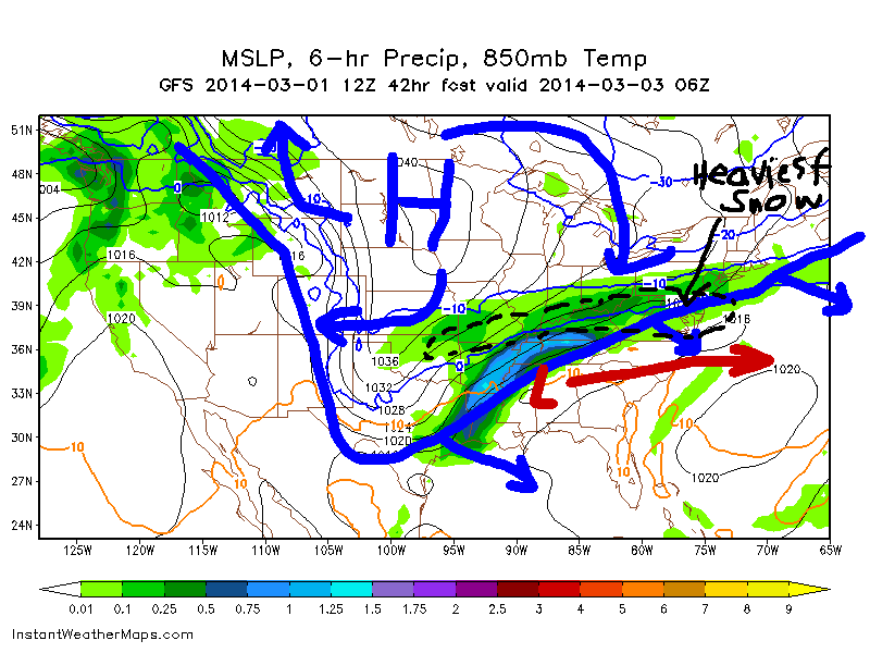
Look at the size of that thing in SE CA

_________________
_______________________________________________________________________________________________________
CLICK HERE to view NJ Strong Snowstorm Classifications
Frank_Wx- Godzilla Seeker
- Posts : 21305
Reputation : 328
Join date : 2013-01-05
Age : 31
Location : Jersey City, NJ -
Re: 1st Call Snow Map, March 3rd-4th Storm Discussion 2.0
![]() by NjWeatherGuy Sat Mar 01, 2014 10:54 am
by NjWeatherGuy Sat Mar 01, 2014 10:54 am
Frank_Wx wrote:NYC actually gets a solid 6 inches on the GFS. No one should be upset by this run. It is great for March standards.
Of course, I've been saying that the overrunning now has a decent chance to deliver most of the snowfall, we're just missing the main storm which is annoying given it's friggin suppression by the PV in March which is Meteorological spring, however, considering around I-95 nearly all March storms of the past 20 years have been less than a foot. This may be record breaking for those jerks down south lol.
NjWeatherGuy- Advanced Forecaster
- Posts : 4100
Reputation : 28
Join date : 2013-01-06
Location : Belle Mead, NJ
Re: 1st Call Snow Map, March 3rd-4th Storm Discussion 2.0
![]() by amugs Sat Mar 01, 2014 10:55 am
by amugs Sat Mar 01, 2014 10:55 am
_________________
Mugs
AKA:King: Snow Weenie
Self Proclaimed
WINTER 2014-15 : 55.12" +.02 for 6 coatings (avg. 35")
WINTER 2015-16 Total - 29.8" (Avg 35")
WINTER 2016-17 : 39.5" so far
amugs- Advanced Forecaster - Mod
- Posts : 15093
Reputation : 213
Join date : 2013-01-07
Age : 54
Location : Hillsdale,NJ
Re: 1st Call Snow Map, March 3rd-4th Storm Discussion 2.0
![]() by aiannone Sat Mar 01, 2014 10:55 am
by aiannone Sat Mar 01, 2014 10:55 am
_________________
-Alex Iannone-
aiannone- Senior Enthusiast - Mod
- Posts : 4813
Reputation : 92
Join date : 2013-01-07
Location : Saint James, LI (Northwest Suffolk Co.)
Re: 1st Call Snow Map, March 3rd-4th Storm Discussion 2.0
![]() by skinsfan1177 Sat Mar 01, 2014 10:56 am
by skinsfan1177 Sat Mar 01, 2014 10:56 am

skinsfan1177- Senior Enthusiast
- Posts : 4485
Reputation : 35
Join date : 2013-01-07
Age : 46
Location : Point Pleasant Boro
Re: 1st Call Snow Map, March 3rd-4th Storm Discussion 2.0
![]() by Frank_Wx Sat Mar 01, 2014 10:56 am
by Frank_Wx Sat Mar 01, 2014 10:56 am
NjWeatherGuy wrote:Frank_Wx wrote:NYC actually gets a solid 6 inches on the GFS. No one should be upset by this run. It is great for March standards.
Of course, I've been saying that the overrunning now has a decent chance to deliver most of the snowfall, we're just missing the main storm which is annoying given it's friggin suppression by the PV in March which is Meteorological spring, however, considering around I-95 nearly all March storms of the past 20 years have been less than a foot. This may be record breaking for those jerks down south lol.
This has been the winter that defies the odds. I do not think I am surprised about anything that happens anymore. Although, I admit this is most surprising. Possibly near 12 inches of snow from DC to Philly. In March. Wow
_________________
_______________________________________________________________________________________________________
CLICK HERE to view NJ Strong Snowstorm Classifications
Frank_Wx- Godzilla Seeker
- Posts : 21305
Reputation : 328
Join date : 2013-01-05
Age : 31
Location : Jersey City, NJ -
Re: 1st Call Snow Map, March 3rd-4th Storm Discussion 2.0
![]() by pdubz Sat Mar 01, 2014 10:57 am
by pdubz Sat Mar 01, 2014 10:57 am

pdubz- Pro Enthusiast

- Posts : 539
Reputation : 0
Join date : 2013-09-24
Age : 32
Location : Port Washington,NY (L.I)
Re: 1st Call Snow Map, March 3rd-4th Storm Discussion 2.0
![]() by Frank_Wx Sat Mar 01, 2014 10:57 am
by Frank_Wx Sat Mar 01, 2014 10:57 am
Mets2695 wrote:So would it be wise to tell people who are hounding me for snow accumulations that it looks like more of a 3-6" event for us now or should i stick with my 6-10" that i downgraded to early this morning?
I would say 5-9 inches.
_________________
_______________________________________________________________________________________________________
CLICK HERE to view NJ Strong Snowstorm Classifications
Frank_Wx- Godzilla Seeker
- Posts : 21305
Reputation : 328
Join date : 2013-01-05
Age : 31
Location : Jersey City, NJ -
Re: 1st Call Snow Map, March 3rd-4th Storm Discussion 2.0
![]() by NjWeatherGuy Sat Mar 01, 2014 10:57 am
by NjWeatherGuy Sat Mar 01, 2014 10:57 am
Frank_Wx wrote:It's the PV Tom, not that High.
Look at the size of that thing in SE CA
The storm that's dying and transferring energy right now or the weak ridge? True it is the PV but that high looks awfully overpowering and squashing by the looks of it. Not going to allow NE movement.
NjWeatherGuy- Advanced Forecaster
- Posts : 4100
Reputation : 28
Join date : 2013-01-06
Location : Belle Mead, NJ
Re: 1st Call Snow Map, March 3rd-4th Storm Discussion 2.0
![]() by Frank_Wx Sat Mar 01, 2014 10:58 am
by Frank_Wx Sat Mar 01, 2014 10:58 am
pdubz wrote:What models are left for 12z
GGEM, UKMET, EURO
_________________
_______________________________________________________________________________________________________
CLICK HERE to view NJ Strong Snowstorm Classifications
Frank_Wx- Godzilla Seeker
- Posts : 21305
Reputation : 328
Join date : 2013-01-05
Age : 31
Location : Jersey City, NJ -
Re: 1st Call Snow Map, March 3rd-4th Storm Discussion 2.0
![]() by Frank_Wx Sat Mar 01, 2014 11:01 am
by Frank_Wx Sat Mar 01, 2014 11:01 am
It is worth mentioning that if there is a bump northward of 20+ miles, which Iv'e seen before this close before an event, we are back into the heavier snow amounts of 7+ inches. Do not forget, the main show starts Sunday night. So we have 00z runs tonight AND 12z runs tomorrow. Even so, GFS was still 6-9 inches for NYC.
_________________
_______________________________________________________________________________________________________
CLICK HERE to view NJ Strong Snowstorm Classifications
Frank_Wx- Godzilla Seeker
- Posts : 21305
Reputation : 328
Join date : 2013-01-05
Age : 31
Location : Jersey City, NJ -
Re: 1st Call Snow Map, March 3rd-4th Storm Discussion 2.0
![]() by skinsfan1177 Sat Mar 01, 2014 11:01 am
by skinsfan1177 Sat Mar 01, 2014 11:01 am
skinsfan1177- Senior Enthusiast
- Posts : 4485
Reputation : 35
Join date : 2013-01-07
Age : 46
Location : Point Pleasant Boro
Re: 1st Call Snow Map, March 3rd-4th Storm Discussion 2.0
![]() by Artechmetals Sat Mar 01, 2014 11:01 am
by Artechmetals Sat Mar 01, 2014 11:01 am

Artechmetals- Pro Enthusiast
- Posts : 571
Reputation : 3
Join date : 2014-01-01
Age : 57
Location : Wayne , NJ
Re: 1st Call Snow Map, March 3rd-4th Storm Discussion 2.0
![]() by Frank_Wx Sat Mar 01, 2014 11:01 am
by Frank_Wx Sat Mar 01, 2014 11:01 am
skinsfan1177 wrote:Whats the start time and ending look like
I'll have those up around 2pm today
_________________
_______________________________________________________________________________________________________
CLICK HERE to view NJ Strong Snowstorm Classifications
Frank_Wx- Godzilla Seeker
- Posts : 21305
Reputation : 328
Join date : 2013-01-05
Age : 31
Location : Jersey City, NJ -
Re: 1st Call Snow Map, March 3rd-4th Storm Discussion 2.0
![]() by Frank_Wx Sat Mar 01, 2014 11:02 am
by Frank_Wx Sat Mar 01, 2014 11:02 am
_________________
_______________________________________________________________________________________________________
CLICK HERE to view NJ Strong Snowstorm Classifications
Frank_Wx- Godzilla Seeker
- Posts : 21305
Reputation : 328
Join date : 2013-01-05
Age : 31
Location : Jersey City, NJ -
Page 8 of 13 • 1, 2, 3 ... 7, 8, 9 ... 11, 12, 13 ![]()
|
|
|