
 Search
Tracking 01-30 Arctic Front
Page 1 of 9 • 1, 2, 3, 4, 5, 6, 7, 8, 9 ![]()

Tracking 01-30 Arctic Front
![]() by Frank_Wx Fri Jan 25, 2019 9:40 am
by Frank_Wx Fri Jan 25, 2019 9:40 am

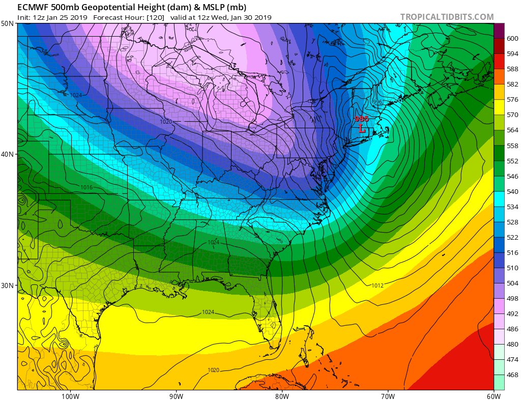
The PV sticks out like a sore thumb. What's interesting is the Arctic Front is actually NOT the main show here. It is the possible coastal storm that develops from a phase between southern energy and PV energy.
Lets compare the GFS and CMC for a second.
GFS:

CMC:

The trough on the CMC is much sharper and negatively tilted. This allows a coastal storm to develop and drop significant snow over the area. The PV is situated far enough N&W to not interfere with the dynamics between the southern and northern stream energy. A phase happens and a storm forms.
The GFS, however, has the PV much closer to the coast and it basically prevents phasing from occurring. It only has the Arctic Front passing through late Tuesday night dropping an inch or 2 of snow. The CMC separates the energy associated with the Arctic Front and focuses on the southern stream energy instead.
Let's look at the CMC 7am Tuesday morning

Look how the southern energy hangs back in Texas. It is also very potent.
Now the GFS same time frame...

The southern energy is essentially connected to the energy associated with the arctic front. Notice how it drapes across Texas then up to the Great Lakes. MAIN POINT: CMC KEEPS THESE ENTITIES SEPARATED
I do not have access to the EURO this year but I found this image of the EURO Ensembles.

It is definitely in the CMC camp and not the GFS camp with developing a coastal storm. As long as the PV stays back far enough to not interfere with the phasing, then we could be in good shape. Refer back to the first image I posted. We have a +PNA (too far west for my liking but better than nothing), a -EPO and a developing -NAO. The NAO is key here too. If there are signs of weakness it could prevent the phasing from happening along the coast. We need a nice -NAO, -EPO, and southern stream energy to stay disconnect from the arctic front. If these things happen we will see a Mothrazilla or Godzilla type of storm. New England is in a much better position than we are to seeing something 'pop.'
And if we do not get the coastal it likely means we're getting the arctic front. I never want to use the phrase win-win scenario, not in this winter, but with all that cold and energy around it I truly think something comes from it.
Let's see what happens.
_________________
_______________________________________________________________________________________________________
CLICK HERE to view NJ Strong Snowstorm Classifications

Frank_Wx- Godzilla Seeker

- Posts : 21305
Reputation : 328
Join date : 2013-01-05
Age : 32
Location : Jersey City, NJ -

Re: Tracking 01-30 Arctic Front
![]() by billg315 Fri Jan 25, 2019 9:54 am
by billg315 Fri Jan 25, 2019 9:54 am

billg315- Advanced Forecaster - Mod

- Posts : 4483
Reputation : 185
Join date : 2015-01-24
Age : 50
Location : Flemington, NJ
Re: Tracking 01-30 Arctic Front
![]() by billg315 Fri Jan 25, 2019 10:02 am
by billg315 Fri Jan 25, 2019 10:02 am
billg315- Advanced Forecaster - Mod
- Posts : 4483
Reputation : 185
Join date : 2015-01-24
Age : 50
Location : Flemington, NJ
Re: Tracking 01-30 Arctic Front
![]() by amugs Fri Jan 25, 2019 11:11 am
by amugs Fri Jan 25, 2019 11:11 am
_________________
Mugs
AKA:King: Snow Weenie
Self Proclaimed
WINTER 2014-15 : 55.12" +.02 for 6 coatings (avg. 35")
WINTER 2015-16 Total - 29.8" (Avg 35")
WINTER 2016-17 : 39.5" so far

amugs- Advanced Forecaster - Mod
- Posts : 15095
Reputation : 213
Join date : 2013-01-07
Age : 54
Location : Hillsdale,NJ
Re: Tracking 01-30 Arctic Front
![]() by heehaw453 Fri Jan 25, 2019 1:32 pm
by heehaw453 Fri Jan 25, 2019 1:32 pm
heehaw453- Advanced Forecaster

- Posts : 3906
Reputation : 86
Join date : 2014-01-20
Location : Bedminster Township, PA Elevation 600' ASL
Re: Tracking 01-30 Arctic Front
![]() by sroc4 Fri Jan 25, 2019 1:41 pm
by sroc4 Fri Jan 25, 2019 1:41 pm
heehaw453 wrote:Lol. 12Z Euro. Shows miller b redevelopment off Delmarva and bombs out to 985 over eastern CT. Tad too far west but believe it’d produce verbatim.
Changes aloft cont in a subtle manor across the modeling, but the changes have been encouraging. Still work to do
We Track!!

_________________
"In weather and in life, there's no winning and losing; there's only winning and learning."
WINTER 2012/2013 TOTALS 43.65"WINTER 2017/2018 TOTALS 62.85" WINTER 2022/2023 TOTALS 4.9"
WINTER 2013/2014 TOTALS 64.85"WINTER 2018/2019 TOTALS 14.25" WINTER 2023/2024 TOTALS 13.1"
WINTER 2014/2015 TOTALS 71.20"WINTER 2019/2020 TOTALS 6.35"
WINTER 2015/2016 TOTALS 35.00"WINTER 2020/2021 TOTALS 37.75"
WINTER 2016/2017 TOTALS 42.25"WINTER 2021/2022 TOTALS 31.65"

sroc4- Admin
- Posts : 8354
Reputation : 302
Join date : 2013-01-07
Location : Wading River, LI
Re: Tracking 01-30 Arctic Front
![]() by heehaw453 Fri Jan 25, 2019 1:52 pm
by heehaw453 Fri Jan 25, 2019 1:52 pm
heehaw453- Advanced Forecaster
- Posts : 3906
Reputation : 86
Join date : 2014-01-20
Location : Bedminster Township, PA Elevation 600' ASL
Re: Tracking 01-30 Arctic Front
![]() by weatherwatchermom Fri Jan 25, 2019 1:57 pm
by weatherwatchermom Fri Jan 25, 2019 1:57 pm
sroc4 wrote:heehaw453 wrote:Lol. 12Z Euro. Shows miller b redevelopment off Delmarva and bombs out to 985 over eastern CT. Tad too far west but believe it’d produce verbatim.
Changes aloft cont in a subtle manor across the modeling, but the changes have been encouraging. Still work to do
We Track!!
question are there maps being posted? I am not seeing any..just curious

weatherwatchermom- Senior Enthusiast

- Posts : 3793
Reputation : 78
Join date : 2014-11-25
Location : Hazlet Township, NJ
Re: Tracking 01-30 Arctic Front
![]() by sroc4 Fri Jan 25, 2019 2:30 pm
by sroc4 Fri Jan 25, 2019 2:30 pm
weatherwatchermom wrote:sroc4 wrote:heehaw453 wrote:Lol. 12Z Euro. Shows miller b redevelopment off Delmarva and bombs out to 985 over eastern CT. Tad too far west but believe it’d produce verbatim.
Changes aloft cont in a subtle manor across the modeling, but the changes have been encouraging. Still work to do
We Track!!
question are there maps being posted? I am not seeing any..just curious
I have not posted any maps
_________________
"In weather and in life, there's no winning and losing; there's only winning and learning."
WINTER 2012/2013 TOTALS 43.65"WINTER 2017/2018 TOTALS 62.85" WINTER 2022/2023 TOTALS 4.9"
WINTER 2013/2014 TOTALS 64.85"WINTER 2018/2019 TOTALS 14.25" WINTER 2023/2024 TOTALS 13.1"
WINTER 2014/2015 TOTALS 71.20"WINTER 2019/2020 TOTALS 6.35"
WINTER 2015/2016 TOTALS 35.00"WINTER 2020/2021 TOTALS 37.75"
WINTER 2016/2017 TOTALS 42.25"WINTER 2021/2022 TOTALS 31.65"
sroc4- Admin
- Posts : 8354
Reputation : 302
Join date : 2013-01-07
Location : Wading River, LI
Re: Tracking 01-30 Arctic Front
![]() by SENJsnowman Fri Jan 25, 2019 2:35 pm
by SENJsnowman Fri Jan 25, 2019 2:35 pm
"There is potential with this system for some decent snow, especially in the northwest CWA and especially if a solution like the ECMWF or CMC verifies."
But they also say this:
"Farther south and east, temperatures are more marginal, so snow amounts would be lower
(which would also be true if the storm`s track trends westward)."
Just curious, if this low actually does track east off the coast to the point that the whole coastal plain is on the NW quadrant of the precip shield, could it STILL be warm enough for the coast to rain/mix at that point?
Ha ha... that sure would be a fitting outcome for this winter...but could that actually happen given the actual pieces in play for this go 'round?
SENJsnowman- Senior Enthusiast
- Posts : 1189
Reputation : 61
Join date : 2017-01-06
Age : 51
Location : Bayville, NJ
Re: Tracking 01-30 Arctic Front
![]() by sroc4 Fri Jan 25, 2019 2:37 pm
by sroc4 Fri Jan 25, 2019 2:37 pm
GFS:


EURO:


_________________
"In weather and in life, there's no winning and losing; there's only winning and learning."
WINTER 2012/2013 TOTALS 43.65"WINTER 2017/2018 TOTALS 62.85" WINTER 2022/2023 TOTALS 4.9"
WINTER 2013/2014 TOTALS 64.85"WINTER 2018/2019 TOTALS 14.25" WINTER 2023/2024 TOTALS 13.1"
WINTER 2014/2015 TOTALS 71.20"WINTER 2019/2020 TOTALS 6.35"
WINTER 2015/2016 TOTALS 35.00"WINTER 2020/2021 TOTALS 37.75"
WINTER 2016/2017 TOTALS 42.25"WINTER 2021/2022 TOTALS 31.65"
sroc4- Admin
- Posts : 8354
Reputation : 302
Join date : 2013-01-07
Location : Wading River, LI
Re: Tracking 01-30 Arctic Front
![]() by sroc4 Fri Jan 25, 2019 2:42 pm
by sroc4 Fri Jan 25, 2019 2:42 pm
SENJsnowman wrote:Mt Holly has been checking in here apparently:
"There is potential with this system for some decent snow, especially in the northwest CWA and especially if a solution like the ECMWF or CMC verifies."
But they also say this:
"Farther south and east, temperatures are more marginal, so snow amounts would be lower
(which would also be true if the storm`s track trends westward)."
Just curious, if this low actually does track east off the coast to the point that the whole coastal plain is on the NW quadrant of the precip shield, could it STILL be warm enough for the coast to rain/mix at that point?
Ha ha... that sure would be a fitting outcome for this winter...but could that actually happen given the actual pieces in play for this go 'round?
I would say if the arctic frontal boundary gets off the coast and the LP wave forms along it to our S&E and additional energy from a spoke of the PV dives into the back side then we all snow. But if the arctic boundary stalls and the southern energy comes in ahead it then maybe there could be some boundary layer issues related to exact track
_________________
"In weather and in life, there's no winning and losing; there's only winning and learning."
WINTER 2012/2013 TOTALS 43.65"WINTER 2017/2018 TOTALS 62.85" WINTER 2022/2023 TOTALS 4.9"
WINTER 2013/2014 TOTALS 64.85"WINTER 2018/2019 TOTALS 14.25" WINTER 2023/2024 TOTALS 13.1"
WINTER 2014/2015 TOTALS 71.20"WINTER 2019/2020 TOTALS 6.35"
WINTER 2015/2016 TOTALS 35.00"WINTER 2020/2021 TOTALS 37.75"
WINTER 2016/2017 TOTALS 42.25"WINTER 2021/2022 TOTALS 31.65"
sroc4- Admin
- Posts : 8354
Reputation : 302
Join date : 2013-01-07
Location : Wading River, LI
Re: Tracking 01-30 Arctic Front
![]() by amugs Fri Jan 25, 2019 2:47 pm
by amugs Fri Jan 25, 2019 2:47 pm
ILL take it an drun.......................

_________________
Mugs
AKA:King: Snow Weenie
Self Proclaimed
WINTER 2014-15 : 55.12" +.02 for 6 coatings (avg. 35")
WINTER 2015-16 Total - 29.8" (Avg 35")
WINTER 2016-17 : 39.5" so far
amugs- Advanced Forecaster - Mod
- Posts : 15095
Reputation : 213
Join date : 2013-01-07
Age : 54
Location : Hillsdale,NJ
Re: Tracking 01-30 Arctic Front
![]() by SENJsnowman Fri Jan 25, 2019 2:58 pm
by SENJsnowman Fri Jan 25, 2019 2:58 pm
sroc4 wrote:SENJsnowman wrote:Mt Holly has been checking in here apparently:
"There is potential with this system for some decent snow, especially in the northwest CWA and especially if a solution like the ECMWF or CMC verifies."
But they also say this:
"Farther south and east, temperatures are more marginal, so snow amounts would be lower
(which would also be true if the storm`s track trends westward)."
Just curious, if this low actually does track east off the coast to the point that the whole coastal plain is on the NW quadrant of the precip shield, could it STILL be warm enough for the coast to rain/mix at that point?
Ha ha... that sure would be a fitting outcome for this winter...but could that actually happen given the actual pieces in play for this go 'round?
I would say if the arctic frontal boundary gets off the coast and the LP wave forms along it to our S&E and additional energy from a spoke of the PV dives into the back side then we all snow. But if the arctic boundary stalls and the southern energy comes in ahead it then maybe there could be some boundary layer issues related to exact track
Excellent. Thank you SROC. So, for us on the coast, it's not just whether a coastal low develops off the coast, which has to happen, but also where the frontal boundary sets up- on or off the coast. A tougher bulls-eye to hit generally speaking, but this also leads to a higher reward due to increased qpfs and better chance for banding generally speaking, right?
SENJsnowman- Senior Enthusiast
- Posts : 1189
Reputation : 61
Join date : 2017-01-06
Age : 51
Location : Bayville, NJ
Re: Tracking 01-30 Arctic Front
![]() by jmanley32 Fri Jan 25, 2019 3:47 pm
by jmanley32 Fri Jan 25, 2019 3:47 pm
its warm that's inland how would it snow except into northern my pa and new England?amugs wrote:EURO BOOYAHH!!
ILL take it an drun.......................

jmanley32- Senior Enthusiast
- Posts : 20535
Reputation : 108
Join date : 2013-12-12
Age : 43
Location : Yonkers, NY
Re: Tracking 01-30 Arctic Front
![]() by amugs Fri Jan 25, 2019 4:18 pm
by amugs Fri Jan 25, 2019 4:18 pm
Huh where do u see warmth there? Its an arctic front .jmanley32 wrote:its warm that's inland how would it snow except into northern ?? my pa and new England?amugs wrote:EURO BOOYAHH!!
ILL take it an drun.......................
_________________
Mugs
AKA:King: Snow Weenie
Self Proclaimed
WINTER 2014-15 : 55.12" +.02 for 6 coatings (avg. 35")
WINTER 2015-16 Total - 29.8" (Avg 35")
WINTER 2016-17 : 39.5" so far
amugs- Advanced Forecaster - Mod
- Posts : 15095
Reputation : 213
Join date : 2013-01-07
Age : 54
Location : Hillsdale,NJ
Re: Tracking 01-30 Arctic Front
![]() by sroc4 Fri Jan 25, 2019 4:45 pm
by sroc4 Fri Jan 25, 2019 4:45 pm
amugs wrote:Huh where do u see warmth there? Its an arctic front .jmanley32 wrote:its warm that's inland how would it snow except into northern ?? my pa and new England?amugs wrote:EURO BOOYAHH!!
ILL take it an drun.......................
Its a tricky set up. Thermal profiles will be diff to pin point. There is much to be ironed out here. As modeled the image Mugsy posted above looks like this at the surface and 925mb. (Note: 850 is below freezing over the entrire area). Just look at the diff at the surface. the diff between 34* and 24* is only a few miles. At 925 the diff between -12* and +1* is only a few miles. Like every storm thermal profiles need to be taken with a grain of salt at this lead time. How the the upper level features interact is still up in the air so Im focused on that first.


_________________
"In weather and in life, there's no winning and losing; there's only winning and learning."
WINTER 2012/2013 TOTALS 43.65"WINTER 2017/2018 TOTALS 62.85" WINTER 2022/2023 TOTALS 4.9"
WINTER 2013/2014 TOTALS 64.85"WINTER 2018/2019 TOTALS 14.25" WINTER 2023/2024 TOTALS 13.1"
WINTER 2014/2015 TOTALS 71.20"WINTER 2019/2020 TOTALS 6.35"
WINTER 2015/2016 TOTALS 35.00"WINTER 2020/2021 TOTALS 37.75"
WINTER 2016/2017 TOTALS 42.25"WINTER 2021/2022 TOTALS 31.65"
sroc4- Admin
- Posts : 8354
Reputation : 302
Join date : 2013-01-07
Location : Wading River, LI
Re: Tracking 01-30 Arctic Front
![]() by SENJsnowman Fri Jan 25, 2019 5:03 pm
by SENJsnowman Fri Jan 25, 2019 5:03 pm
I only go back to '12-13 up here, and I'm wrong a lot...but is that as rare as it seems to me for a winter storm setup?
SENJsnowman- Senior Enthusiast
- Posts : 1189
Reputation : 61
Join date : 2017-01-06
Age : 51
Location : Bayville, NJ
Re: Tracking 01-30 Arctic Front
![]() by billg315 Fri Jan 25, 2019 5:47 pm
by billg315 Fri Jan 25, 2019 5:47 pm

billg315- Advanced Forecaster - Mod
- Posts : 4483
Reputation : 185
Join date : 2015-01-24
Age : 50
Location : Flemington, NJ
Re: Tracking 01-30 Arctic Front
![]() by heehaw453 Fri Jan 25, 2019 5:58 pm
by heehaw453 Fri Jan 25, 2019 5:58 pm
The lack of blocking IMO has really hurt this winter. Storms cut or move way too close for any chance at anything meaningful. The blocking always seems to be just 10 short days away and then the slider bar moves again.
heehaw453- Advanced Forecaster
- Posts : 3906
Reputation : 86
Join date : 2014-01-20
Location : Bedminster Township, PA Elevation 600' ASL
Re: Tracking 01-30 Arctic Front
![]() by amugs Fri Jan 25, 2019 7:01 pm
by amugs Fri Jan 25, 2019 7:01 pm
You can get a quick developing LP on an arctic front and blocking isn't it all for this set up.heehaw453 wrote:This has potential to produce something more, but I feel it will be like what GFS is depicting. A quick moving arctic front that is rain to snow yielding a C-1. It's been pretty darned consistent with that.
The lack of blocking IMO has really hurt this winter. Storms cut or move way too close for any chance at anything meaningful. The blocking always seems to be just 10 short days away and then the slider bar moves again.
_________________
Mugs
AKA:King: Snow Weenie
Self Proclaimed
WINTER 2014-15 : 55.12" +.02 for 6 coatings (avg. 35")
WINTER 2015-16 Total - 29.8" (Avg 35")
WINTER 2016-17 : 39.5" so far
amugs- Advanced Forecaster - Mod
- Posts : 15095
Reputation : 213
Join date : 2013-01-07
Age : 54
Location : Hillsdale,NJ
Re: Tracking 01-30 Arctic Front
![]() by amugs Fri Jan 25, 2019 7:04 pm
by amugs Fri Jan 25, 2019 7:04 pm

_________________
Mugs
AKA:King: Snow Weenie
Self Proclaimed
WINTER 2014-15 : 55.12" +.02 for 6 coatings (avg. 35")
WINTER 2015-16 Total - 29.8" (Avg 35")
WINTER 2016-17 : 39.5" so far
amugs- Advanced Forecaster - Mod
- Posts : 15095
Reputation : 213
Join date : 2013-01-07
Age : 54
Location : Hillsdale,NJ
Re: Tracking 01-30 Arctic Front
![]() by amugs Fri Jan 25, 2019 8:46 pm
by amugs Fri Jan 25, 2019 8:46 pm


_________________
Mugs
AKA:King: Snow Weenie
Self Proclaimed
WINTER 2014-15 : 55.12" +.02 for 6 coatings (avg. 35")
WINTER 2015-16 Total - 29.8" (Avg 35")
WINTER 2016-17 : 39.5" so far
amugs- Advanced Forecaster - Mod
- Posts : 15095
Reputation : 213
Join date : 2013-01-07
Age : 54
Location : Hillsdale,NJ
Re: Tracking 01-30 Arctic Front
![]() by jmanley32 Fri Jan 25, 2019 9:06 pm
by jmanley32 Fri Jan 25, 2019 9:06 pm
jmanley32- Senior Enthusiast
- Posts : 20535
Reputation : 108
Join date : 2013-12-12
Age : 43
Location : Yonkers, NY
Re: Tracking 01-30 Arctic Front
![]() by jmanley32 Fri Jan 25, 2019 9:07 pm
by jmanley32 Fri Jan 25, 2019 9:07 pm
now that looks great even for coast.amugs wrote:EPS baby riding it like seasbiscit peeps all the way!!
jmanley32- Senior Enthusiast
- Posts : 20535
Reputation : 108
Join date : 2013-12-12
Age : 43
Location : Yonkers, NY
Page 1 of 9 • 1, 2, 3, 4, 5, 6, 7, 8, 9 ![]()
|
|
|