
 Search
Tracking 01-30 Arctic Front
Page 7 of 9 •  1, 2, 3, 4, 5, 6, 7, 8, 9
 ![]()
Re: Tracking 01-30 Arctic Front
![]() by 1190ftalt Tue Jan 29, 2019 3:47 pm
by 1190ftalt Tue Jan 29, 2019 3:47 pm
1190ftalt- Pro Enthusiast

- Posts : 401
Join date : 2013-12-13
Re: Tracking 01-30 Arctic Front
![]() by heehaw453 Tue Jan 29, 2019 3:48 pm
by heehaw453 Tue Jan 29, 2019 3:48 pm
heehaw453- Advanced Forecaster

- Posts : 3906
Join date : 2014-01-20
Re: Tracking 01-30 Arctic Front
![]() by jimv45 Tue Jan 29, 2019 3:50 pm
by jimv45 Tue Jan 29, 2019 3:50 pm
jimv45- Senior Enthusiast

- Posts : 1168
Reputation : 36
Join date : 2013-09-20
Location : Hopewell jct.
Re: Tracking 01-30 Arctic Front
![]() by hyde345 Tue Jan 29, 2019 3:59 pm
by hyde345 Tue Jan 29, 2019 3:59 pm
Last edited by hyde345 on Tue Jan 29, 2019 4:00 pm; edited 1 time in total

hyde345- Pro Enthusiast
- Posts : 1082
Reputation : 48
Join date : 2013-01-08
Location : Hyde Park, NY
jimv45- Senior Enthusiast
- Posts : 1168
Reputation : 36
Join date : 2013-09-20
Location : Hopewell jct.
Re: Tracking 01-30 Arctic Front
![]() by hyde345 Tue Jan 29, 2019 4:02 pm
by hyde345 Tue Jan 29, 2019 4:02 pm
jimv45 wrote:mix heading to hyde
Hope not. still all snow. I'll let you know if it does though.
hyde345- Pro Enthusiast
- Posts : 1082
Reputation : 48
Join date : 2013-01-08
Location : Hyde Park, NY
Re: Tracking 01-30 Arctic Front
![]() by jimv45 Tue Jan 29, 2019 4:05 pm
by jimv45 Tue Jan 29, 2019 4:05 pm
jimv45- Senior Enthusiast
- Posts : 1168
Reputation : 36
Join date : 2013-09-20
Location : Hopewell jct.
jimv45- Senior Enthusiast
- Posts : 1168
Reputation : 36
Join date : 2013-09-20
Location : Hopewell jct.
Re: Tracking 01-30 Arctic Front
![]() by hyde345 Tue Jan 29, 2019 4:10 pm
by hyde345 Tue Jan 29, 2019 4:10 pm
jimv45 wrote:Raining and 31 here.
Where are you located? Wappingers? Fishkill?
hyde345- Pro Enthusiast
- Posts : 1082
Reputation : 48
Join date : 2013-01-08
Location : Hyde Park, NY
Re: Tracking 01-30 Arctic Front
![]() by heehaw453 Tue Jan 29, 2019 4:11 pm
by heehaw453 Tue Jan 29, 2019 4:11 pm
heehaw453- Advanced Forecaster
- Posts : 3906
Reputation : 86
Join date : 2014-01-20
Location : Bedminster Township, PA Elevation 600' ASL
jimv45- Senior Enthusiast
- Posts : 1168
Reputation : 36
Join date : 2013-09-20
Location : Hopewell jct.
Re: Tracking 01-30 Arctic Front
![]() by hyde345 Tue Jan 29, 2019 4:15 pm
by hyde345 Tue Jan 29, 2019 4:15 pm
hyde345- Pro Enthusiast
- Posts : 1082
Reputation : 48
Join date : 2013-01-08
Location : Hyde Park, NY
Re: Tracking 01-30 Arctic Front
![]() by jimv45 Tue Jan 29, 2019 4:18 pm
by jimv45 Tue Jan 29, 2019 4:18 pm
jimv45- Senior Enthusiast
- Posts : 1168
Reputation : 36
Join date : 2013-09-20
Location : Hopewell jct.
Re: Tracking 01-30 Arctic Front
![]() by hyde345 Tue Jan 29, 2019 4:19 pm
by hyde345 Tue Jan 29, 2019 4:19 pm
jimv45 wrote:Yes hope for you! It will go back later to snow here but not expecting more then an inch.
I have 2 inches OTG. What do you have right now?
hyde345- Pro Enthusiast
- Posts : 1082
Reputation : 48
Join date : 2013-01-08
Location : Hyde Park, NY
Re: Tracking 01-30 Arctic Front
![]() by jmanley32 Tue Jan 29, 2019 4:26 pm
by jmanley32 Tue Jan 29, 2019 4:26 pm

jmanley32- Senior Enthusiast
- Posts : 20535
Reputation : 108
Join date : 2013-12-12
Age : 43
Location : Yonkers, NY
Re: Tracking 01-30 Arctic Front
![]() by jimv45 Tue Jan 29, 2019 4:28 pm
by jimv45 Tue Jan 29, 2019 4:28 pm
jimv45- Senior Enthusiast
- Posts : 1168
Reputation : 36
Join date : 2013-09-20
Location : Hopewell jct.
Re: Tracking 01-30 Arctic Front
![]() by billg315 Tue Jan 29, 2019 4:31 pm
by billg315 Tue Jan 29, 2019 4:31 pm

billg315- Advanced Forecaster - Mod

- Posts : 4483
Reputation : 185
Join date : 2015-01-24
Age : 50
Location : Flemington, NJ
Re: Tracking 01-30 Arctic Front
![]() by hyde345 Tue Jan 29, 2019 4:32 pm
by hyde345 Tue Jan 29, 2019 4:32 pm
jimv45 wrote:Hyde I have wet grounds with just a trace of snow left on grass.
That sucks. That 25 miles north and west(right near river) of you is making a big difference with this one.
hyde345- Pro Enthusiast
- Posts : 1082
Reputation : 48
Join date : 2013-01-08
Location : Hyde Park, NY
Re: Tracking 01-30 Arctic Front
![]() by jimv45 Tue Jan 29, 2019 4:34 pm
by jimv45 Tue Jan 29, 2019 4:34 pm
jimv45- Senior Enthusiast
- Posts : 1168
Reputation : 36
Join date : 2013-09-20
Location : Hopewell jct.
Re: Tracking 01-30 Arctic Front
![]() by billg315 Tue Jan 29, 2019 4:43 pm
by billg315 Tue Jan 29, 2019 4:43 pm
billg315- Advanced Forecaster - Mod
- Posts : 4483
Reputation : 185
Join date : 2015-01-24
Age : 50
Location : Flemington, NJ
Re: Tracking 01-30 Arctic Front
![]() by heehaw453 Tue Jan 29, 2019 4:49 pm
by heehaw453 Tue Jan 29, 2019 4:49 pm
heehaw453- Advanced Forecaster
- Posts : 3906
Reputation : 86
Join date : 2014-01-20
Location : Bedminster Township, PA Elevation 600' ASL
Re: Tracking 01-30 Arctic Front
![]() by Dtone Tue Jan 29, 2019 5:09 pm
by Dtone Tue Jan 29, 2019 5:09 pm
Dtone- Wx Statistician Guru

- Posts : 1738
Reputation : 9
Join date : 2013-08-26
Location : Bronx, NY

Vinnydula- Pro Enthusiast
- Posts : 778
Reputation : 8
Join date : 2013-12-12
Location : Dobbs ferry
Re: Tracking 01-30 Arctic Front
![]() by amugs Tue Jan 29, 2019 5:19 pm
by amugs Tue Jan 29, 2019 5:19 pm
.NEAR TERM /UNTIL 6 AM WEDNESDAY MORNING/...
A low along the cold front will move across this evening at the
surface. The timeframe for remaining precipitation will be
through 06-07Z Wed.
The height falls continue at 500mb. The main shortwave moving
along the southeast periphery of a longwave trough moves near
and south of the region this evening. The will increase positive
vorticity advection making for a bulk of precip between 00-06Z
Wed.
There will be potential for widespread snow on the back end
with the cold air advection on the W-NW flow late this evening
into the overnight. This will be quite brief for locations east
of NYC. The front itself with low pressure developing along it
moves across. The increase in low level omega will provide
vertical forcing and drier air infiltrating the region will
allow for wet bulb cooling with the lingering rain transitioning
along coastal areas to lingering snow.
For interior areas and now including Northern New Haven, will
have most snow accumulation in the evening, mostly 3-5 inches.
So, winter weather advisory includes same areas as before but
now includes Northern New Haven CT.
Will have to watch for coastal areas turning back over to snow
on back side of low with that colder air advecting in on the
westerly flow. High end potential for around 2 inches of snow at
the coast with this but likely 1 inch or less while interior
areas could get 1-2 inches higher than forecast. Temperatures
overnight into early Wed drop below freezing making for areas of
black ice.
Brief high pressure enters the region late tonight with a
decrease in clouds. Cold air advection continues on the westerly
flow which will become more gusty. Lows were taken from a
consensus of raw data, mid teens to mid 20s for most of the
area.
_________________
Mugs
AKA:King: Snow Weenie
Self Proclaimed
WINTER 2014-15 : 55.12" +.02 for 6 coatings (avg. 35")
WINTER 2015-16 Total - 29.8" (Avg 35")
WINTER 2016-17 : 39.5" so far

amugs- Advanced Forecaster - Mod
- Posts : 15095
Reputation : 213
Join date : 2013-01-07
Age : 54
Location : Hillsdale,NJ
Re: Tracking 01-30 Arctic Front
![]() by amugs Tue Jan 29, 2019 5:27 pm
by amugs Tue Jan 29, 2019 5:27 pm
From noon to 5pm ish for the area.
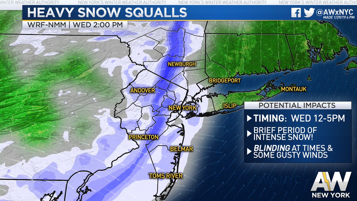
Close Up

Behind this arctic front temps drop like a rock bigly!!
Wind Chills Thursday morning range from -15 to -25 Below zero for the area

_________________
Mugs
AKA:King: Snow Weenie
Self Proclaimed
WINTER 2014-15 : 55.12" +.02 for 6 coatings (avg. 35")
WINTER 2015-16 Total - 29.8" (Avg 35")
WINTER 2016-17 : 39.5" so far
amugs- Advanced Forecaster - Mod
- Posts : 15095
Reputation : 213
Join date : 2013-01-07
Age : 54
Location : Hillsdale,NJ
Re: Tracking 01-30 Arctic Front
![]() by heehaw453 Tue Jan 29, 2019 5:32 pm
by heehaw453 Tue Jan 29, 2019 5:32 pm
heehaw453- Advanced Forecaster
- Posts : 3906
Reputation : 86
Join date : 2014-01-20
Location : Bedminster Township, PA Elevation 600' ASL
Re: Tracking 01-30 Arctic Front
![]() by heehaw453 Tue Jan 29, 2019 5:33 pm
by heehaw453 Tue Jan 29, 2019 5:33 pm
amugs wrote:Snow squalls tomorrow are gonna be crazy peeps - Coating to 2" is possible with white out condition s- these are being modeled stronger with each run and the soundings are supportive if not stronger that what is being shown.
From noon to 5pm ish for the area.
Close Up
Behind this arctic front temps drop like a rock bigly!!
Wind Chills Thursday morning range from -15 to -25 Below zero for the area
This to me is going to be unbelievable for those lucky enough to get under the squalls! It will be quite a show!
heehaw453- Advanced Forecaster
- Posts : 3906
Reputation : 86
Join date : 2014-01-20
Location : Bedminster Township, PA Elevation 600' ASL
Page 7 of 9 • 1, 2, 3, 4, 5, 6, 7, 8, 9 ![]()
|
|
|