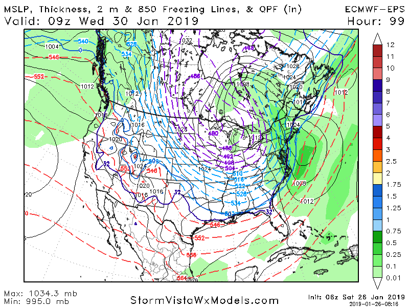
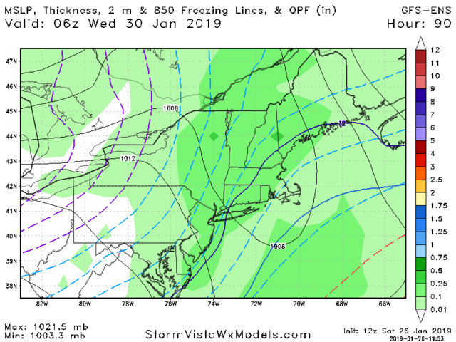
Tracking 01-30 Arctic Front
+29
photec
brownie
Dtone
sabamfa
1190ftalt
CPcantmeasuresnow
Grselig
Scullybutcher
Vinnydula
RJB8525
mako460
bobjohnsonforthehall
jimv45
Fededle22
Dunnzoo
dkodgis
docstox12
hyde345
mwilli5783
frank 638
Irish
jmanley32
SENJsnowman
weatherwatchermom
sroc4
heehaw453
amugs
billg315
Frank_Wx
33 posters
Page 2 of 9 •  1, 2, 3, 4, 5, 6, 7, 8, 9
 Re: Tracking 01-30 Arctic Front
Ok no need bite my head off I saw low west of city and snow map doesn't show much from west of city on east. But yes we can't take temp profiles verbatim not this far put anyways. Ill root for anything that will get me a snow day. I get 2 a year and is like to get them Damn it lol
jmanley32- Senior Enthusiast

- Posts : 20535
Join date : 2013-12-12
 Re: Tracking 01-30 Arctic Front

_________________
Mugs
AKA:King: Snow Weenie
Self Proclaimed
WINTER 2014-15 : 55.12" +.02 for 6 coatings (avg. 35")
WINTER 2015-16 Total - 29.8" (Avg 35")
WINTER 2016-17 : 39.5" so far

amugs- Advanced Forecaster - Mod

- Posts : 15095
Reputation : 213
Join date : 2013-01-07
Age : 54
Location : Hillsdale,NJ
 Re: Tracking 01-30 Arctic Front
The real deal right there^^^^^
_________________
Mugs
AKA:King: Snow Weenie
Self Proclaimed
WINTER 2014-15 : 55.12" +.02 for 6 coatings (avg. 35")
WINTER 2015-16 Total - 29.8" (Avg 35")
WINTER 2016-17 : 39.5" so far

amugs- Advanced Forecaster - Mod

- Posts : 15095
Reputation : 213
Join date : 2013-01-07
Age : 54
Location : Hillsdale,NJ
 Re: Tracking 01-30 Arctic Front
Amugs, is the a map/ chart in your 9:39 post that i'm just not seeing?

Irish- Pro Enthusiast

- Posts : 788
Reputation : 19
Join date : 2019-01-16
Age : 45
Location : Old Bridge, NJ
 Re: Tracking 01-30 Arctic Front
I guess nothing to track..no one on

weatherwatchermom- Senior Enthusiast

- Posts : 3793
Reputation : 78
Join date : 2014-11-25
Location : Hazlet Township, NJ
 Re: Tracking 01-30 Arctic Front
Its Friday night mom everyone is out.

jmanley32- Senior Enthusiast

- Posts : 20535
Reputation : 108
Join date : 2013-12-12
Age : 43
Location : Yonkers, NY
 Re: Tracking 01-30 Arctic Front
For YBY?? So did 12 Z. It was close. The cold press is real and popping so many SE members is a good sign.
There is a storm signal and let's keep this IMBY out of her please, I can see it coming. Your like ravenous dogs who smell food us snow starced snowneeenies. We can see 2 storms in a 4 -5 day period, next look's to be supper bowl weekend, hoping for Sunday!!
There is a storm signal and let's keep this IMBY out of her please, I can see it coming. Your like ravenous dogs who smell food us snow starced snowneeenies. We can see 2 storms in a 4 -5 day period, next look's to be supper bowl weekend, hoping for Sunday!!
_________________
Mugs
AKA:King: Snow Weenie
Self Proclaimed
WINTER 2014-15 : 55.12" +.02 for 6 coatings (avg. 35")
WINTER 2015-16 Total - 29.8" (Avg 35")
WINTER 2016-17 : 39.5" so far

amugs- Advanced Forecaster - Mod

- Posts : 15095
Reputation : 213
Join date : 2013-01-07
Age : 54
Location : Hillsdale,NJ
 Re: Tracking 01-30 Arctic Front
Who's asking IMBY, I was talking in general the entire area, but after reading about the thermal profiles between 925mb and 850mb its def a difficult think to predict so not concerned at this point. And whatever you posted that you were honking at above the picture did not show up even after refreshing several times and trying another browser, there def is a issue with the pics Frank, maybe you can look into your host site that hosts the pics? Dunno where exactly the issue would be but there have been numerous complaints about the same thing.amugs wrote:For YBY?? So did 12 Z. It was close. The cold press is real and popping so many SE members is a good sign.
There is a storm signal and let's keep this IMBY out of her please, I can see it coming. Your like ravenous dogs who smell food us snow starced snowneeenies. We can see 2 storms in a 4 -5 day period, next look's to be supper bowl weekend, hoping for Sunday!!

jmanley32- Senior Enthusiast

- Posts : 20535
Reputation : 108
Join date : 2013-12-12
Age : 43
Location : Yonkers, NY
 Re: Tracking 01-30 Arctic Front
EPS folks still honking and with with about 84 to go it's looking good. The Coastal has jumped further east as the Ridge in the North Atlantic presses on it and this is good it will keep the flow NE for us on its backside and slow up this front and lock it some cold air. Let's see where we go today and hioedully we can get a plowist storm for all!! Can't posts map for some reason being mobile. Sorry
_________________
Mugs
AKA:King: Snow Weenie
Self Proclaimed
WINTER 2014-15 : 55.12" +.02 for 6 coatings (avg. 35")
WINTER 2015-16 Total - 29.8" (Avg 35")
WINTER 2016-17 : 39.5" so far

amugs- Advanced Forecaster - Mod

- Posts : 15095
Reputation : 213
Join date : 2013-01-07
Age : 54
Location : Hillsdale,NJ
 Re: Tracking 01-30 Arctic Front
_________________
Mugs
AKA:King: Snow Weenie
Self Proclaimed
WINTER 2014-15 : 55.12" +.02 for 6 coatings (avg. 35")
WINTER 2015-16 Total - 29.8" (Avg 35")
WINTER 2016-17 : 39.5" so far

amugs- Advanced Forecaster - Mod

- Posts : 15095
Reputation : 213
Join date : 2013-01-07
Age : 54
Location : Hillsdale,NJ
 Re: Tracking 01-30 Arctic Front
sounds good let's hope this is how trend because I am sick and tired of getting cold then rain storms then back to coldamugs wrote:EPS folks still honking and with with about 84 to go it's looking good. The Coastal has jumped further east as the Ridge in the North Atlantic presses on it and this is good it will keep the flow NE for us on its backside and slow up this front and lock it some cold air. Let's see where we go today and hioedully we can get a plowist storm for all!! Can't posts map for some reason being mobile. Sorry
frank 638- Senior Enthusiast

- Posts : 2843
Reputation : 37
Join date : 2016-01-01
Age : 40
Location : bronx ny
 Re: Tracking 01-30 Arctic Front
frank 638 wrote:sounds good let's hope this is how trend because I am sick and tired of getting cold then rain storms then back to coldamugs wrote:EPS folks still honking and with with about 84 to go it's looking good. The Coastal has jumped further east as the Ridge in the North Atlantic presses on it and this is good it will keep the flow NE for us on its backside and slow up this front and lock it some cold air. Let's see where we go today and hioedully we can get a plowist storm for all!! Can't posts map for some reason being mobile. Sorry
Amen Frank...you've been speaking my mind all winter man.
OK...now we are out of the long range, into the mid range, and we are still tracking something worth tracking. And it's not even trending crappier at the moment.
So, as this threat figures out how to belly-up itself from here, we do appear to be making progress!
SENJsnowman- Senior Enthusiast

- Posts : 1189
Reputation : 61
Join date : 2017-01-06
Age : 51
Location : Bayville, NJ
 Re: Tracking 01-30 Arctic Front
great write up senj mugs and frank,like all in here waiting 4 plow able snow and the"m" word
mwilli5783- Posts : 146
Reputation : 9
Join date : 2013-01-23
Age : 69
Location : hempstead n.y
 Re: Tracking 01-30 Arctic Front
_________________
Mugs
AKA:King: Snow Weenie
Self Proclaimed
WINTER 2014-15 : 55.12" +.02 for 6 coatings (avg. 35")
WINTER 2015-16 Total - 29.8" (Avg 35")
WINTER 2016-17 : 39.5" so far

amugs- Advanced Forecaster - Mod

- Posts : 15095
Reputation : 213
Join date : 2013-01-07
Age : 54
Location : Hillsdale,NJ
 Re: Tracking 01-30 Arctic Front
I'm NOT trying to say I think it's going to snow.
I just want to see if I'm getting some of this stuff right.
Following Frank's lead (Frank W_x, that is), I'm comparing the 00z GFS with the 12z for 18z on Wed. I think I see 3 improvements at the upper level.
1. Most significantly, the trough looks negative to me in the 12z. It also looks like the that 492 circle is a tad further south.
2. It looks like the n and s parts are trying to phase on 12z. They don't, but that's seems at least better...
3. While still strung out and weak, the southern stream is better- longer fuller.


That's what I see...is that the right read/takeaway?
I just want to see if I'm getting some of this stuff right.
Following Frank's lead (Frank W_x, that is), I'm comparing the 00z GFS with the 12z for 18z on Wed. I think I see 3 improvements at the upper level.
1. Most significantly, the trough looks negative to me in the 12z. It also looks like the that 492 circle is a tad further south.
2. It looks like the n and s parts are trying to phase on 12z. They don't, but that's seems at least better...
3. While still strung out and weak, the southern stream is better- longer fuller.


That's what I see...is that the right read/takeaway?
SENJsnowman- Senior Enthusiast

- Posts : 1189
Reputation : 61
Join date : 2017-01-06
Age : 51
Location : Bayville, NJ
 Re: Tracking 01-30 Arctic Front
SENJsnowman wrote: ...is that the right read/takeaway?
Any chance I can get even a Y/N, no explanation needed...
SENJsnowman- Senior Enthusiast

- Posts : 1189
Reputation : 61
Join date : 2017-01-06
Age : 51
Location : Bayville, NJ
 Re: Tracking 01-30 Arctic Front
I'm not sure but I can say that from the model runs surface the coast and even well inland is mostly rain again...and a flooding one at that. I'm sure that's what will happen I have no faith left in this winter or lack there of.

jmanley32- Senior Enthusiast

- Posts : 20535
Reputation : 108
Join date : 2013-12-12
Age : 43
Location : Yonkers, NY
 Re: Tracking 01-30 Arctic Front
18z NAM seems to be developing a secondary Tuesday along the front in the Carolinas and bringing it up the coast Tuesday night. Also a little colder with mostly snow with the frontal passage. 18z GFS still starts with rain and mainly just a frontal passage but more aggressive on the backside snow.

billg315- Advanced Forecaster - Mod

- Posts : 4483
Reputation : 185
Join date : 2015-01-24
Age : 50
Location : Flemington, NJ
 Re: Tracking 01-30 Arctic Front
If the NAM played out I think we might have something to work with Tuesday night into Wednesday.

billg315- Advanced Forecaster - Mod

- Posts : 4483
Reputation : 185
Join date : 2015-01-24
Age : 50
Location : Flemington, NJ
 Re: Tracking 01-30 Arctic Front
SENJ I think 18z Wednesday is probably too late in the day to look at for clues. This will mostly play out Tuesday into Wednesday morning. I’d keep an eye on the upper levels on the Monday night through Tuesday night maps to see how it’s coming together.

billg315- Advanced Forecaster - Mod

- Posts : 4483
Reputation : 185
Join date : 2015-01-24
Age : 50
Location : Flemington, NJ
 Re: Tracking 01-30 Arctic Front
billg315 wrote:SENJ I think 18z Wednesday is probably too late in the day to look at for clues. This will mostly play out Tuesday into Wednesday morning. I’d keep an eye on the upper levels on the Monday night through Tuesday night maps to see how it’s coming together.
Roger that. So, is what I'm looking at actually bad news, b/c it already missed the phase? does the 12z map I posted shows some of what we needed, but too little and too late in the game?
SENJsnowman- Senior Enthusiast

- Posts : 1189
Reputation : 61
Join date : 2017-01-06
Age : 51
Location : Bayville, NJ
 Re: Tracking 01-30 Arctic Front
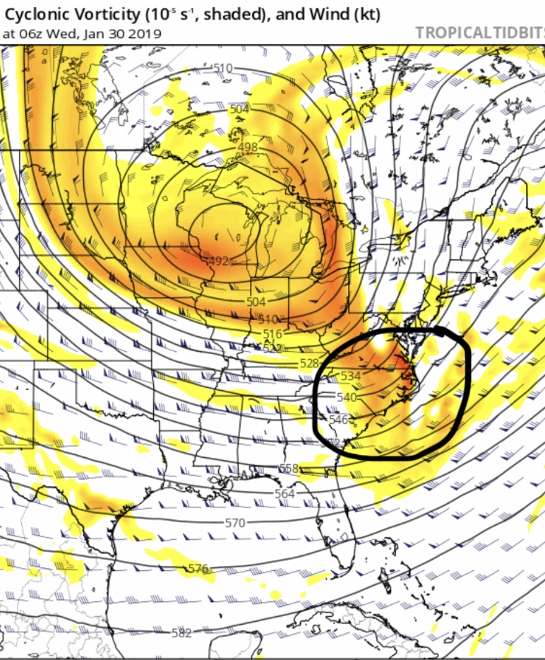
If you remember Frank saying above it would be good for the southern energy to hang back a bit and stay apart from the arctic front I think the NAM indicates some of that. The southern energy seems to keep its own identity and the arctic front up north is less dominant. Then the southern energy consolidates over the Carolinas and swings north. Not sure how good this all is but it’s a better look than GFS:
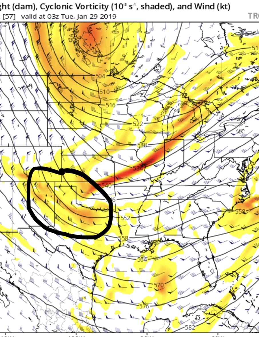
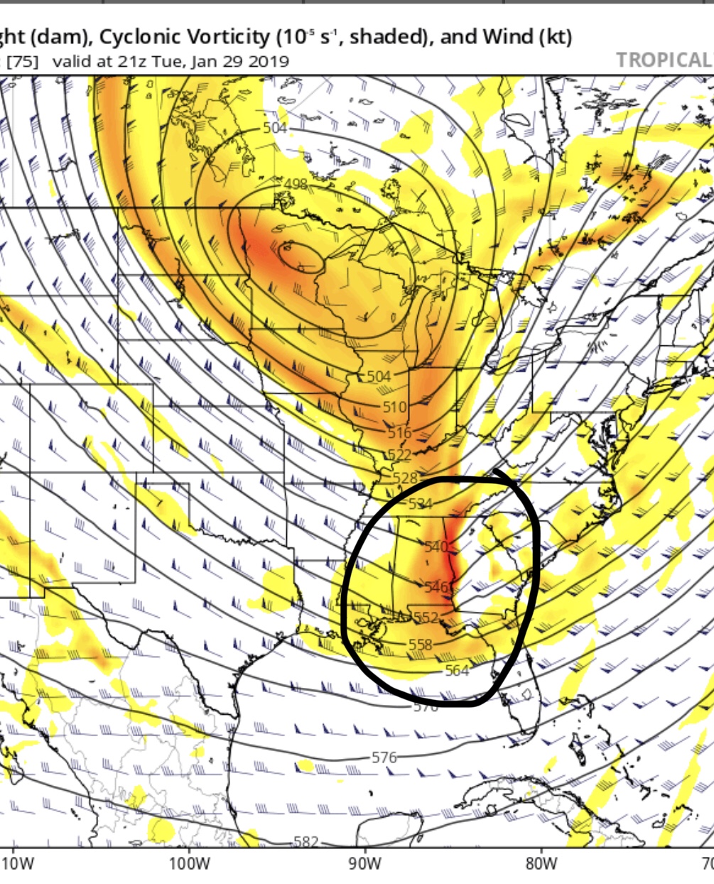


billg315- Advanced Forecaster - Mod

- Posts : 4483
Reputation : 185
Join date : 2015-01-24
Age : 50
Location : Flemington, NJ
 Re: Tracking 01-30 Arctic Front
Inside the 95 I wouldn’t expect more than c-1 attm. I think 81 corridor does best with this. Very frustrating winter. Hopefully this renders pleasant surprise.
heehaw453- Advanced Forecaster

- Posts : 3906
Reputation : 86
Join date : 2014-01-20
Location : Bedminster Township, PA Elevation 600' ASL
 Re: Tracking 01-30 Arctic Front
jmanley32 wrote:I'm not sure but I can say that from the model runs surface the coast and even well inland is mostly rain again...and a flooding one at that. I'm sure that's what will happen I have no faith left in this winter or lack there of.
Saw that too, JMAN.
I wish vegas would open a line for these threats. For this one, I dont like the cutter, but I'd jump on suppressed ots at -125. You could prob get 5-1 or better if you have the cajones to bet on the snow.
SENJsnowman- Senior Enthusiast

- Posts : 1189
Reputation : 61
Join date : 2017-01-06
Age : 51
Location : Bayville, NJ
 Re: Tracking 01-30 Arctic Front
If the GFS is right this is an inch or two at best. A cold front alone in January won’t cut it. But if the NAM is right and a Low will be sitting over Delmarva Tuesday night with the 850 line well off the coast, I think things could be interesting.

billg315- Advanced Forecaster - Mod

- Posts : 4483
Reputation : 185
Join date : 2015-01-24
Age : 50
Location : Flemington, NJ
 Re: Tracking 01-30 Arctic Front
I totally follow that Bill, well both posts, but that first one was awesome...thank you. very helpful
HeeHaw, are you thinking the 81 corridor gets snow from the northern boundary front, but that the 95 misses out b/c the southern stream coastal never comes together?
Or cutter? (I'm thinking it's this one ^^)
HeeHaw, are you thinking the 81 corridor gets snow from the northern boundary front, but that the 95 misses out b/c the southern stream coastal never comes together?
Or cutter? (I'm thinking it's this one ^^)
Last edited by SENJsnowman on Sat Jan 26, 2019 7:11 pm; edited 1 time in total
SENJsnowman- Senior Enthusiast

- Posts : 1189
Reputation : 61
Join date : 2017-01-06
Age : 51
Location : Bayville, NJ
Page 2 of 9 •  1, 2, 3, 4, 5, 6, 7, 8, 9
Permissions in this forum:
You cannot reply to topics in this forum|
|
|

 Home
Home


